Specifics
Duration: 5.25 hours; 8:00 a.m.- 1:15 pm
Summits: Whiteface: 3.5 hours, 11:30 a.m.
Route: Main Entrance – Slopes to Slide Out Region – Ski Slide 4 – North Ridge - Summit.
Total Mileage/Vertical Ascent: 8.0/4400
Trail Conditions: Dry trail conditions with small pockets of snow at about 3700’
Temperature: 80’s, mild humidity
Wildlife: Major Blackflies (yes, in August), chickadees, garter snake on slopes
Background
Although it is the “sacrificial lamb” of the Adirondack High Peaks, Whiteface is my favorite mountain in the Adirondacks. It’s angular rock is different from nearly all the other high peaks, and the relief from base to peak is nearly double the area’s average. Furthermore, instead of merely being a peak on a range of mountains, Whiteface is a massif covering approximately 17 square miles. Our route would have us ascending nearly 3,700’ over approximately 2¼ miles (average 31% slope or 19° grade). All of these characteristics give the mountain a very Alpine feel.
The Ski Slides on Whiteface Mountain are the result of erosion gone amuk in a glacial cirque. Basically, when the force of gravity overcomes the friction between the thin Adirondack soils and the rock below, a slide is formed. Think of an avalanche… but instead of snow, it is trees, soil, and rock that explode down the mountainside. There are a total of five bare slides within the cirque. A possible sixth slide appears to be overgrown.
MudRat's Account:
The purpose of this hike was to scout a route up Whiteface that exited close to Lookout Mountain and, let’s face it, for the fun of another slide hike. The goal was a small spur off Ski Slide #5 which angles upward to Lookout Mountain. Some label it Ski Slide #6. Let me say ahead of time that I screwed up and led us onto Ski Slide #4 which was a bit more precipitous and led closer to Whiteface than we planned. Missing the original goal also served as a future excuse to go back and climb #5. Neither of us were too upset about the misroute. This marked my fifth ascent up Whiteface and WWBF’s seventh. Another wouldn’t hurt!
The Approach
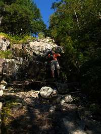
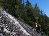
![Whiteface Ski Slide 4 Initial Slab]() WWBF entering the slide
WWBF entering the slide
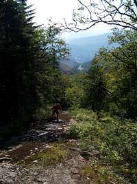
The plan was to climb Ski Slide #5 in anticipation of next year’s 46 Traverse. The day started with a grueling hour-long 2,000-foot ascent up the ski slopes to the base of the slides. Old friends, the blackflies, greeted me at the base. How wonderful of them to make an appearance nearly two months after their typical season.
We now had to descend in an easterly direction to reach the base of Ski Slide #5. Soon after we began our descent, MudRat stated that spotted the base of the slide. I thought it was much too early, but he was confident, and I honestly couldn’t have cared less on this nearly perfect August morning.
MudRat's Account:
As we got out of the car, the breeze kicked in and blew my hair. I said a silent prayer of thanks since I’ve become a creature of the cold rather than of heat. It’s been a warm wet summer and a cooler hiking day was most appreciated especially after the bushwhack from Nye to Wanika Falls the day before. The cooler refreshing air was present through the trails adjacent to the brook, but as the trail ended and we entered the wildflower meadows on the ski slopes, all comfort ended and I began to sweat. Somewhere around 1/3 of the way to the base of the slide, the blackflies emerged and swarmed. Yes, blackflies were out in August. Apparently they didn’t know to die in late June. They fed well when they didn’t drown on my brow or temple. The beauty of the area wasn’t lost however as colors exploded all around. The dark blue sky brought purples, yellows and other brilliantly shaded flowers to life.
In contrast, the new ski slope project on the nearby Lookout Mountain bore testament to the destructive power of man. That project was well under way and the new scars were graded and looked fairly clean of debris. As long as Whiteface is the only High Peak that is sacrificed to this type of development, I don’t really have a problem especially since it’s tightly monitored by the DEC. No matter what logic states in my mind, it still makes me a bit sad, however. The new slopes could even provide us a better route for the final climb of the 46 Traverse in 2010.
The grinding incline of the slopes was relentless and I overheated near the bottom of the last slope before the Slide Out region which is a route between the slopes and the slides. We hadn’t stopped or slowed for the seemingly endless march to the start of our goal. I was drinking water at an alarming rate and the strain from the prior day’s climb manifested itself on Whiteface. I always felt like this on the slopes, though. They were, after all meant to go down, not up.
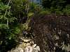
The slides looked the same as when I last saw them in October of 2005 under the dark blue blanket of the sky. This time, however, we descended to a rubble pile and after a minute’s discussion began our climb up the narrow, wet and mossy base of the wrong slide. Our true goal was a few hundred land feet down the main slide’s drainage. C’est la vie, but we didn’t know that at the time. The grade was typical and ledgy, but difficult in that the base rock was moss covered. Care was needed to ensure the sphagnum and other mosses didn’t break the grip of foot to rock. Blow-down was abundant but not overbearing. We each played with our own routes on different sides of the drainage. I awaited the time when it began to open, hoping for a breeze and break from the pesky bugs.
The Climb
![Whiteface Ski Slide 4 Low with WWBF]() Lower Portion
Lower Portion![Whiteface Ski Slide 4 Midsection Start]() Lower Ledges
Lower Ledges![Whiteface Ski Slide 4 Initial Slab]() MudRat climbing the first section of slab
MudRat climbing the first section of slab
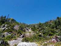
The slide began as a semi-overgrown boulder field, but soon developed into a series of moss-covered benches that were both fun and challenging. Intermittent bands of thick brush greeted us in the places were vegetation could grab hold.
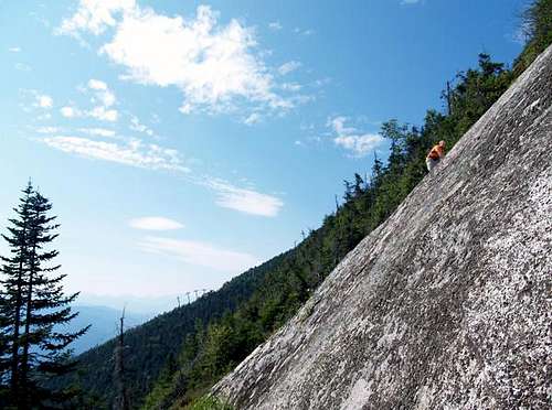
After nearly 200 feet of climbing, the slide developed into the open slab that we were expecting. After this initial 200 feet, I also confirmed that we were on Ski Slide #4, not #5. I knew from a previous ascent up Ski Slide #3, during which I angled over to Ski Slide #4, that things were gonna get STEEP! The average grade of this slide approaches 45 degrees, and it gets steeper as you ascend.
The next few hundred feet of climbing were great. The rock was good and dry, and allowed different routes of varying difficulty. MudRat and I took many pictures of each other, joking yelling “Hang On” to the other as we focused the camera. As the rock got steeper, the choice of routes dwindled, and the climbing got more difficult. MudRat angled towards the trees, but I felt confident and stayed on the open slab… often pausing to “connect the dots” of handholds and footholds above me.
Nearly three-quarters of the way up, we ran into a thick band of gnarly trees. Pushing and winding our way through the trunks and branches, we emerged at the 60-degree headwall. MudRat couldn’t get enough traction to ascend the slab, so he angled to the right where he could utilize the trees. But I was determined to get up this slab. I failed on my first three attempts, but on my fourth attempt, I was able to pedestal on a shallow depression in the rock while balancing my right foot on a nub. From this position, I was able to reach better handholds above me, and soon ascended to a concave horizontal intrusion where I could catch my breath. I noticed a thin crack angling up and to my right, and chose it as the way up the next pitch. I told MudRat to take some photos as I ascended the crack. Unfortunately, it ran out a little sooner than I expected, and had to rely on shallow depressions for handhold and footholds to ascend the final five feet to the top of a thin grassy bench.
The climbing didn’t get much easier as we kept ascending. MudRat required a hand or a foot brace in a couple of areas, but we continued on. At the top of the open slab, MudRat had to traverse a five-foot section of loose soil and rock. As he traversed, he knocked an angular softball-sized rock loose, and it went tumbling down the steep wall until it ended with a deadened thump when it made a direct hit on a tree trunk 100 feet below.
We now entered a section that required bushwhacking through cripplebrush and over rock ledges. Just shy of the summit ridge, MudRat and I found ourselves on a nice flat ledge… the first flat land since we began our climb. MudRat angled to the right up the next ledge while I tackled a vertical 10-foot wall to the left. This wall had great handholds and footholds, and I had no apprehension about climbing it. As I neared the top, my hands ran out of rock and had to grab onto a tree to pull me up the final foot. Although I double-checked the stability of this tree, it decided to break halfway through my move. Instinctually, I looked down the wall and in slow-motion-time, saw a good foothold that would arrest my pending fall. As luck would have it, the flake crumbled when I placed my weight on it, and I was now in freefall. The next thing I knew, I was hanging from one hand on the now horizontal broken tree… like a basketball player after a slam dunk. I released my grip, fell the remaining two feet to the ground, and decided that MudRat’s route was better.
Once on the ridge, the trail lay only 15 feet in front of us. We decided to head for the summit instead of descending down Ski Slide #5… which we’ll save for another day!
MudRat's Account:
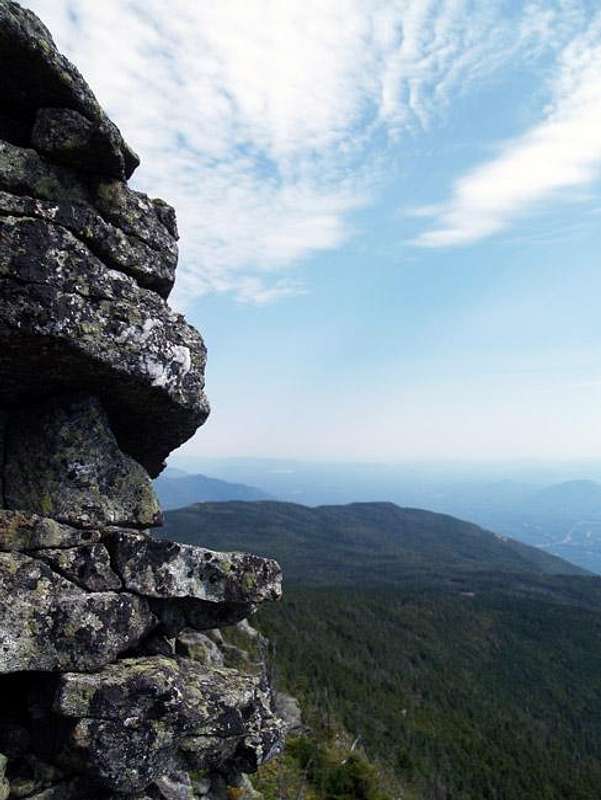
About midway up, I got my wish and my spirits lifted adding a little spring to my step and adrenalin to my system. Most of the still-ledgy incline spotted with parched moss and lichen. The moss held our grip. The lichen did not. The slide was still narrow enough that it didn’t give an overwhelming sense of exposure, though the view back toward the Sentinel Range was spectacular. The distant ski slopes rolled ever downward adding depth to a surprisingly hazy vista. Intrusions crossed various areas of the slide as they usually do and added small foot and handholds at various intervals. I’d estimate the angle to be about 35 to 40 degrees with the occasional steeper section. The steepest inclines were yet to come. I was warned and I could see the slide loom overhead as it became increasingly concave until the ridge.
The day was spectacular for photography and I used the opportunity to capture the spirit of the mountain, Rico climbing and gave the camera to him to capture my ascent. The Super Hero Spiderman transformed himself into the Stupid Hero Spiderfool once again as we found ourselves beginning the open slabs of the upper sections. Had I been alone, I’d have stayed near the sides a bit more, but with Spiderfool nearby to lend a leg I played on the edge of my comfort zone. I didn’t get to play it out fully, however, the final ascent (where WWBF) appears to be clinging to a near vertical face, found my legs wobbly. I explored the route and found there to be a small crack which could provide footholds/handholds, but my legs just didn’t have enough to play it safe. There was enough of a shelf of trees below, so I wouldn’t have fallen to my death, but skin takes time to replace and I wasn’t in the mood. I simply withdrew to the lovely cripple-brush and emerged above. I heard, “Take a photo,” before I was committed to the brush, however, and got a great shot of WWBF on the ascent. It may appear that I tilted the camera to make it look steep, but the trees and skyline attest to the actual rise as will anyone who’s done this.
The top of the final slab was both a relief and incredible overlook. It was only about thirty vertical feet below the rocky ridgeline of the mountain where I’ve walked before, but had the perspective of looking directly down the slide. After pictures, it was time to leave the slide which was “easily” done by using the cripplebrush to climb nearly vertically into the thicker brush and finally to the ten foot climb up the lip of the ridge. I rested while WWBF played in the brush and saved himself from a near fall. Several bikers on the last bend of the toll road watched as we emerged.
I asked WWBF if we were going to the summit, only another ¼ mile, or less, and he replied, “…Might as well.” I’d anticipated the answer. If a mountain is that close, we usually climb it even if we’ve achieved our goal. The ridge was an easy trot upward. My first ascent up the ridge found me avoiding the edge (over which I’d just climbed). I remember being dizzy from the height and not even CONSIDERING that fools might actually climb it. Now I am one of the proud fools, or one of them!
The summit was hording the breeze that I’d coveted most of the morning after it swept me at the base. It provided a cool respite for lunch as we sat overlooking Lake Placid and letting our feet dry in the sun. WWBF wanted to hike down the service road to Little Whiteface as an exit. I’d never done it so it sounded good…as long as we stayed off the slopes which are overgrown up high and riddled with rocks. The mountain bike trails and other service roads aided our descent as well and we arrived at the, now, stifling hot car at 1:15 p.m.
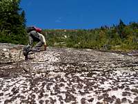
![Whiteface Ski Slide 4 Upper Slab (WWBF)]() WWBF on the headwall
WWBF on the headwall![Whiteface Ski Slide 4]() WWBF at the top of the headwall
WWBF at the top of the headwall![Whiteface Ski Slide 4]() Final pitch
Final pitchAdditional Images
Comments
No comments posted yet.