
|
|
Mountain/Rock |
|---|---|
|
|
45.68148°N / 116.43276°W |
|
|
Idaho |
|
|
Spring, Summer, Fall, Winter |
|
|
5458 ft / 1664 m |
|
|
Overview
I DON'T KNOW WHAT THE HELL HAPPENED TO THE FORMATTING ON THIS PAGE, BUT I'M TRYING TO FIGURE IT OUT. IF YOU HAVE ANY IDEAS LET ME KNOW! Wild Horse Ridge rising from Hells Canyon
 The summit
 North side
 Big Canyon Ck
 Summit from divide
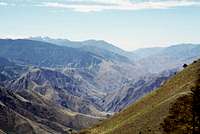 Hells Canyon
 West ridge
 North forest
 Cliff bands
 Prickly pear
 Basalt outcrop
 SW ridge cliffs
 Local residents
 West ridge point
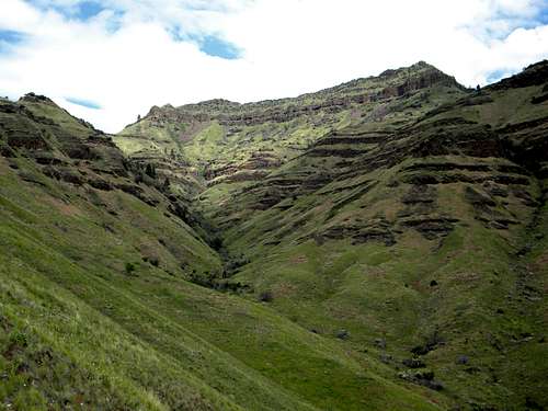 Looking up the southwest draw
Wild Horse Butte is a locally significant high point rising precipitously on the Idaho side of Hells Canyon. Though it is only 5,458 feet in elevation with 478 feet of prominence, it abruptly rises over 4,300 feet from the bottom of the canyon and strikes an imposing profile with its well formed pyramid toping the rugged basalt reefs of Wild Horse Ridge. Wild Horse Ridge forms a west running spur into Hells Canyon from the main Salmon/Snake divide, which positions it for some of the most stunning views of the giant canyon. The south slope rises gradually, then abruptly into a series of basalt layers that are passable only by a few openings. Climbing the rocks associated with these layers is dangerous because they are prone to give way under pressure. On the south the ridge is bordered by Kurry Creek, which forms a broad valley with a flat bottom and the only real road into Hells Canyon. The north side falls sharply into Big Canyon Creek, which is extremely rugged with much of the canyon fairly inaccessible. The north slope was densely forested with fir trees, but the severe Poe Cabin forest fire in 2007 burned these along with nearly 60,000 acres on the east side of the Snake River.
Geologically the area was uplifted by the colliding of the Pacific Terrane into the North American Terrane. Approximately 18 million years ago an ongoing series of lava flood eruptions coated much of the inland northwest with layers of basalt, which can clearly be discerned on the high walls of the canyon. In the more deeply cut canyons lower layers of grey, powdery soils of depositional origin can be found. The Snake River eventually cut Hells Canyon giving the spectacular landscape of the area today. Erosion of the slopes has left a badlands-like landscape of deeply cut draws divided by steep ridges and rocky formations. Soils over the basalt are generally thin and with the dry, hot climate most the area supports grasslands with trees only found on the more mild protected slopes.
Ecologically the area is significant for supporting the northern distributional limits of several plant species more typically found well to the south in desert areas of the United States. Given the substantial spring rains of the northwest, this harsh world has a period where the layered ledges become saturated and for a time support incredibly beautiful and lush hanging gardens, with a fair number of rare endemic species. There are two plant species listed under the Endangered Species Act and several others that are being considered or have some other formal designation of concern. Unfortunately such habitats are highly susceptible to weed invasion and much of the unique flora has been completely and permanently displaced. The area also supports mule deer, elk, black bear, cougars, and big horn sheep, which undergo population fluctuations. It is also one of the last places the native mountain quail can be found after the introduction of the more competitive California quail and other game birds and its habitat being reduced by weeds.
The area is included in the Hells Canyon National Recreation Area. The road down Kurry Creek to Pittsburg Landing on the Snake River is heavily used three seasons of the year, but given the rugged landscape and lack of easy access anywhere else, it is easy to obtain isolation in the area. Wild Horse Butte is not an easy summit and won’t be reached by casual area visitors. While it is easy to reach the base of the mountain, a climb up the steep slopes of loose soil and rocks or common scree areas can only be done by the determined. Take plenty of water because there is none to be found on the mountain and temperatures on the south slope are often above 100 degrees Fahrenheit in the summer. An unprepared hiker will cook on the hot dark rocks. Fairly common rattlesnakes are another thing to be aware of. In the fall the area is hunted very heavily with weekend hunters running all over the slopes. The area is probably best avoided during open season, but if you must go be sure to wear orange.
Getting There
 East summit ridge
 Starting out
 Climbing to SW ridge
 Lower SE approach
 SW ridge
 SE approach from SW ridge
 Down SW ridge
 Start SW ridge
 SW approach
 Up SW approach
 N end Sw ridge
 Through the cliffs
 Approaching cliffs
 Base of cliffs
 Above the cliffs
 Terminus SW ridge
 Southwest draw and ridge
There are primarily two ways to access this mountain. From the east it is accessible from the Pittsburg Saddle or Motthorn Saddle areas and to the south access if more general from the 493 road down Kurry Creek. Access from the west and north are less practical and will require passing by the given areas to reach them.
To reach the area from Highway 95, turn off on the old Highway 95 road, about a mile south of White Bird. The sign will indicate access to Pittsburg Landing and Hammer Creek. After a short distance, turn left across the bridge over the Salmon River. On the west side of the bridge immediately turn left on the 493 road (also called the Deer Creek Road). Continue on the 493 road according to the desired route given below. It is a little over 10 miles to Pittsburg Saddle and a few more to the flats of Kurry Creek south of the mountain.
From the Salmon/Snake divide
Coming in from the main divide will minimize the elevation to ascend, but will increase the amount of walking unless the Motthorn Saddle road can be driven. Take the main road (493) to Pittsburg Saddle, park and hike the main divide north to where the east end of Wild Horse Ridge connects to the main divide. This includes some significant and unnecessary ascent and drops. If possible it would be better to take the road that turns right off the 493 road a short distance past the 10 mile marker. It’s the only road to the right between Pittsburg Saddle and the house at the National Forest boundary. This inconspicuous road is very easy to miss. If you find yourself at Pittsburg Saddle, looking down into Hells Canyon, you have driven past it. Turn around and look for it a few hundred yards back to the east. There is a good dispersed site about 80 feet east of the junction to park or camp.
This unnumbered road is very narrow and not in good condition. Generally a high clearance vehicle would have no problem, but even then in the spring the road will be wet and require 4wd and there will be some risk of damage to the surface. Also after the Poe Cabin fire of 2007, there are likely many fallen trees across its path. Perhaps locals who run four-wheelers on it have been keeping it open. Motthorn Saddle is almost 2.5 miles up this road from the 493 road. You’ll have to decide if you want to attempt the difficult drive or add nearly 5 miles of hiking to your round trip.
From Motthorn Saddle climb the steep ridgeline to the north. The map shows a trail, National Recreation Trail 105, but it does not appear to be maintained. Pieces of what look like a hiking trail can be found, but in general you will be hiking either an ATV trail or cow trails along a fence. At approximately the 5,200 foot contour of the first steep pitch, cross the fence and get on the cow trail on the west slope and follow it through the saddle between the main ridge and Wild Horse Ridge. From this saddle hike west on the ridge to the high point. It is fairly straightforward, but the top can be narrow in places with jumbled rocks making it a slow go and in some places a fair scramble, even though the way is fairly level.
From the south
Going to the mountain from the south is more direct, but it is steeper and will require more careful route finding. Follow the directions to Pittsburg Saddle and then descend the steep grade as if going to Pittsburg Landing. Once on the bottom there will be some extensive flat country to the north between the mountain and the road. This can be crossed anywhere to reach the base of the mountain for the ascent. However be sure to plan ahead to find a way through the precipitous and loose layers of basalt that often form cliffs and impassable outcrops or scree slopes.
Perhaps the best route may be from near mile marker 14 on the road. Cross the flats near the west end or take the gentle ridge above the flats and head for the main ridge that comes off the west summit ridge point. There are few rocks along this route that need negotiated and steep grasslands will be the main obstacle until the upper mountain is reached. Once near the large prominent outcrop where the ridge connects to the upper mountain, cut across the scree to the east and look ahead to the tall basalt layer for openings. There should be two or three that allow one to scramble up and through the cliff band. Once through, contour on the slope between basalt bands to the southwest aspect of the summit pyramid. There an open run to the top can be found. Routes directly to the high point from below have more potential to run into difficult rocks lower on the summit pyramid. Depending on just where the route is started an ascent from the south will require a hike of a little over two miles and a rise of about 3,000 feet.
 Hells Canyon from Wild Horse Ridge
Red Tape
The area is included in the Hells Canyon National Recreation Area. Generally there is no red tape for recreationists to deal with, except respect access management signes such as keeping motorized vehicles on designated routes etc. Contact the NRA office given below if any specific information is desired.Camping
 Pittsburg Landing
 Looking into Oregon from the southwest approach to Wild Horse Butte
The only designated campgrounds in the area are at Hammer Creek at the base of the Dumeoque Grade on the Salmon River and at Pittsburg Landing on the Snake River, about 8 miles west of Pittsburg Saddle. The latter is very close to the mountain. There are some dispersed camping opportunities along the roads in the area. Perhaps the best is the parking area mentioned near the start of the unnamed road to Motthorn Saddle. There are two roads to the south on the east side of the divide that have scattered opportunities for dispersed camping. Some are quite nice, but the drawback it distance from the mountain and the potential for livestock sharing the campsite.
When To Climb
The best time to do this hike is during the spring. It’s warm, but usually not too hot and the wildflower display can be incredible. During summer temperatures can get very high, often near or above 100 degrees and there is virtually no shade. The mountain can also be hiked in winter, but the access can be difficult and while the lower elevations may be clear of snow, the upper slopes may have heavy snow. Storms can blow up quickly in the huge canyon topography so be prepared for more than one season in any given day. Fall would be a good time, but as previously mentioned, hunters can be thick here. Hanging gardens
Mountain Conditions and Additional Information
 Wild Horse Ridge at day's end
Contact the Salmon River Ranger Districtof the Nez Perce National Forest for local information and current conditions.
Nez Perce National Forest
104 Airport Road
Grangeville, ID 83530
208-983-1950
Salmon River Ranger District
Slate Creek Ranger Station
HC 01, Box 70
Whitebird, ID 83554
(208)839-2211
FAX:(208)839-2730
Hells Canyon NRA
Riggins Field office
189 Highway 95
Riggins, Idaho 83549
(208) 628-3916
NOAA Forcast
[img:584185:aligncenter:medium:Wild Horse Ridge at day's end]