
|
|
Mountain/Rock |
|---|---|
|
|
34.52232°N / 112.55544°W |
|
|
Yavapai |
|
|
Hiking |
|
|
Spring, Summer, Fall, Winter |
|
|
7058 ft / 2151 m |
|
|
Overview
The Williams Peaks are two summits in the Prescott National Forest. They are about 5 miles west of downtown Prescott. They are easily accessible from town and make ideal hiking options for metro Phoenix residents during the spring and fall.
Williams Peak is 7,058’ and South Williams Peak is 7,035’. South Williams Peak only has a prominence of a little over 210’ and is about a mile to the south of Williams Peak. It is just labeled “7035” on topographic maps.
The Williams Peaks are situated along a long ridge of the central Sierra Prieta section of mountains which goes from Granite Mountain to the north to the town of Wilhoit to the south. The ridge hosting the Williams Peaks says “Sierra Prieta” on the topographic map.
Sierra Prieta means “brown mountains”. However, that isn’t a good description of the area, which is heavily forested. In wetter years it is quite green.
Trails along the ridge lead to Williams Peak. South Williams Peak is situated just off a trail a quarter mile from the Sierra Prieta Overlook – labeled “Sunset Overlook”on Google Maps™.
The Williams Peaks are best hiked between March and May, and September and November. Summer heat and fire danger are deterrents in summer months. Winter hiking can easily be done, however, that is dependent on snow conditions. You’ll have a lot less company in colder weather months, but also colder temperatures than the Phoenix metro area.
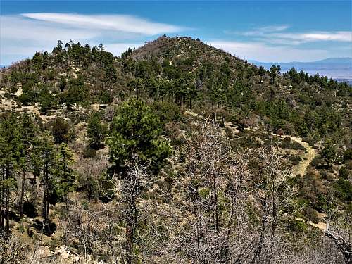 Williams Peak from the south
Getting There
There are two primary starting points. The first is Skyline Drive and the second is Thumb Butte Road.
If coming from I-17 from the Phoenix metro area, both access points are reached by taking Highway 69. For Skyline Drive, once you get off I-17 take Highway 69 for around 20 miles. Turn right on Fain Road, and continue 18 miles to Williamson Valley Road. Turn left and continue south for 2 ½ miles to Iron Springs Road. Take it west for almost four miles to the turn off to Skyline Drive. Once on Skyline Drive, take it until the pavement ends after almost three miles. There are still houses, so you need to take the dirt road for about a quarter mile to find parking. Even though it is only a quarter mile, the road is pretty rough and 4WD is recommended. Although, if need be, you can park on the road to the right just before the pavement ends, and probably fit a couple cars without causing any trouble.
For Thumb Butte Road, it might be better to drive straight to Prescott instead of taking Fain Road. Note that this may be congested, especially during big events in springtime weekends. Once off of I-17, take Highway 69 for 33 miles into downtown Prescott. Get on Gurley Street and continue until you leave the main part of town and it turns into Thumb Butte Road. Once you pass the Thumb Butte parking area, it is about 2 miles further to the turnoff onto the dirt road. For 2WD, there is ample parking just 150 yards up the dirt road at about 6,085’.
Route
From Skyline Drive, once parked past the houses, you have a couple options. First, you can do a loop by turning right about two-thirds of a mile up the road and hike up to West Spruce Mountain 7,167’. After almost a half mile on that road, there is a trail on the right. Take that trail and it connects back to a pack trail after a half a mile. On the way, you can jump off the trail and bag the summit of West Spruce Mountain, which is just 200 yards or so off the trail.
If just hiking up the road to the West Spruce Pack Trail, instead of turning after the junction 2/3rds miles up the road, continue for another half mile on the main road, and there is huge cairn marking the junction with the pack trail.
At this junction turn right and descend down some switchbacks along the trail which continues along the ridge towards Williams Peak. A good marker is the turn-off back to Skyline Drive, with the large cairn. From here, it is about two miles east on the ridge to a turn off to Williams Peak. There is a road on the left that descends a bit, and goes to a low point below Williams Peak. Alternatively, you can stay on the main ridge trail, and there is a trail that leads to the same place. It is only 100 yards more hiking distance,but is an option if you miss the first turn.
If just hiking Williams Peak, the one way hiking distance is about 4 miles, gaining 1,000’. South Williams Peak is another 1 ½ miles further east, accessed via the Sierra Prieta Lookout. That makes it 10 miles round trip, gaining nearly 2,000’ with all the ups and downs. Add West Spruce Peak, and it is over 2,500’ of gain and about 12 miles total hiking.
From the turnoff of Thumb Butte Road, you can of course drive much further with a high clearance 2WD or 4WD. Frankly, a 2WD might have no trouble making it all the way up the road. However, I am providing route information below for this parking area. It is about three miles up the road to the main ridge, between South Williams Peak and Williams Peak. At this point, there is a trail to the right heading west towards Williams Peak.
If hiking South Williams Peak, take a left and continue a half mile up to the Sierra Prieta Overlook. Then take the trail up the ridge for two-tenths of a mile. Then take a right and head to the summit, 80 yards off-trail.
Both summits can be hiked via this route in about 9 ½ miles from the turnoff. The total gain would be about 1,350’.
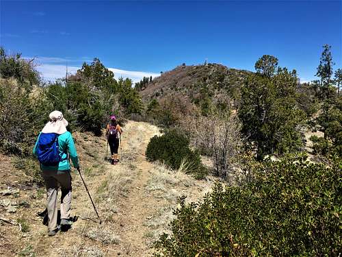 Final path towards Williams Peak
Red Tape
There is no red tape in particular. Just park past the last house if approaching from Skyline Drive. If taking Thumb Butte Road, you should be fine. Check fire conditions and any road closures before taking these routes, especially between May and October.