Sweetwater Gap - Wind River Peak
I planned this trip a couple years ago and finally found the right time to plug it in.
For some reason, I always seem to seek out the less visited pieces of wilderness. Maybe it's because they seem more like wilderness to me.
The destination for this trip was no exception to my rule as we were aiming for the southern end of the Wind River Range and the small, remote Sweetwater Trailhead. Three of us planned to travel over the Sweetwater Gap and into the upper reaches of the Tayo Creek drainage. From our base camp, we planned on doing a lot of fishing and to attempt a climb of Wind River Peak. Good friend and Wind River veteran, Marc Mayotte, would accompany my son Chris and myself. For Chris and I, this would be our third trip into the Winds.
Saturday, August 2nd, 2008
We left Fort Collins at 6:30 am. Rolled into Lander around 11:30 for our last fuel before the trailhead. Luckily for me, since I was driving, Marc had volunteered to pay for the gas. It was $4.03 a gallon, ouch! Backtracked to the Hwy 28 turnoff and began the climb to South Pass.
![Sweetwater Gap]() Mount Nystrom and the Sweetwater Gap - A few scattered ranches and the road are the only signs of civilization
Mount Nystrom and the Sweetwater Gap - A few scattered ranches and the road are the only signs of civilization
Once we were on the other side of the pass, we turned north onto the Lander Cutoff. From there, it was another 23 miles to the TH. The road wasn’t bad but it wasn’t built for speed. The last two miles were a little rough and I was glad that we’d taken the running boards off the 4Runner.
![Sweetwater Trailhead]() Sweetwater Trailhead with Mount Nystrom - No problem finding a place to park here
Sweetwater Trailhead with Mount Nystrom - No problem finding a place to park here
We finally reached the TH at 1:50. Evidence of the fires of 88’ was clearly visible. Before we hit the trail, I put the final touches on my plan to have cold beer waiting for us when we would come out a week later. Dry ice on the bottom of the cooler then block ice with a towel on top for insulation and finally,... six Coronas. I parked in the shade of the only standing tree and off we went, putting one foot in front of the other, at 2:45 pm.
![Larsen Creek Bridge]() Larsen Creek Bridge - Marc crossing the only bridge we'd see on this trip
Larsen Creek Bridge - Marc crossing the only bridge we'd see on this trip
The trail dropped quickly to a bridge over Larsen Creek then began climbing up through a thicket of immature lodgepoles that grew up from the ashes and deadfall left by the fires.
![Sweetwater Gap Trail]() Sweetwater Gap Trail - We took our 1st break here, at the northern edge of the burn
Sweetwater Gap Trail - We took our 1st break here, at the northern edge of the burn
The trail weaved in and out of the burned forest for the next couple miles. Getting through the deadfall was an issue at times. We struggled into the late afternoon under the burden of our full packs and settled into a campsite about a mile shy of the Gap just after 6 pm. Set up camp, had a little dinner then kicked back with a bit of grog and a cigar.
![The Sweetwater River]() Headwaters of the Sweetwater - There was a bit of frost on the grass by the river on this morning
Headwaters of the Sweetwater - There was a bit of frost on the grass by the river on this morning
I was out of the tent first, around 6:30. It was a cool 42F with clear skies. Took a bunch of photos including this one of the Upper Sweetwater River, looking north toward the Gap. Hit the trail at 9:45 after some coffee and a quick breakfast.
![The Sweetwater Gap]() Looking north from the Gap - No people in sight, saw none the first 2 days
Looking north from the Gap - No people in sight, saw none the first 2 days
Made the Gap at 11:15 and took a 40 minute break to eat and reconnoiter. Found the "shortcut, use trail" behind the trail sign, right where Finis said it would be. It wasn't heavily used but easy enough to follow on it's up and down, northwesterly course to Poison Lake.
![Popo Agie/Bridger Wilderness sign]() On the cusp of two wildernesses - Popo Agie left/Bridger right - This sign had been there for awhile, evidenced by the name- Popo Agie Primitive Area and the fact that it's half eaten
On the cusp of two wildernesses - Popo Agie left/Bridger right - This sign had been there for awhile, evidenced by the name- Popo Agie Primitive Area and the fact that it's half eaten![From the Poison Lake Cut-off]() Pond along the Poison Lake Cut-off Trail - Looking east, about a mile from the Gap ~ Photo by Chris Reed
Pond along the Poison Lake Cut-off Trail - Looking east, about a mile from the Gap ~ Photo by Chris Reed![Chris and Mark.......]() Chris and Marc ponder Wind River Peak - Our first good look at it
Chris and Marc ponder Wind River Peak - Our first good look at it![Descending to Poison Lake]() The Poison Lake Cut-off - Looking NW, descending to Poison Lake
The Poison Lake Cut-off - Looking NW, descending to Poison Lake
Followed the trail down the slope to just above the lake where we lost it in the willows.
![Tayo Creek]() Tayo Creek above Poison Lake - A short distance below the Mountain Sheep outlet
Tayo Creek above Poison Lake - A short distance below the Mountain Sheep outlet
From there we bushwhacked westward above the southern shore of the lake, aiming for the outlet of Mountain Sheep Lake. After six hours on the trail, we shed our packs and set up camp at Mtn Sheep Lk. Did a little fishing and were disappointed to find only brookies in the lake. The mosquitoes weren’t insane but they got your attention if you sat in one spot for very long. If you were trying to eat, they were merciless. Enjoyed a cigar, a nip and life was good.
![A moment in time]() Mountain Sheep Lake Camp - Chillin' in the Popo
Mountain Sheep Lake Camp - Chillin' in the Popo
Slept in a little later as part of our planned “do nothing/recovery” day. Temp was a balmy 53F when I got up and I figured the mosquitoes would be waiting for me. Thanks to a stiff breeze coming out of the south, there was none to be found. Spent the morning doing chores, fine tuning the camp set-up, sunning and fishing.
![A friendly wave]() Chris catching some rays - Waving to his dear old dad
Chris catching some rays - Waving to his dear old dad
Early in the afternoon, Chris announced that he was tired of hanging around camp and that he was going to climb the peak that towered over the west side of the lake. I asked him to stay in touch via the two-way and off he went.
![Mountain Sheep Lake]() Looking south over Mountain Sheep Lake - At the beginning of Chris' climb ~ Photo by Chris Reed
Looking south over Mountain Sheep Lake - At the beginning of Chris' climb ~ Photo by Chris Reed
Just when I was starting to think we’d not see another soul in this remote corner of the Winds, a family of five popped out of the forest on the other side of the lake, with fishing rods in hand. Marc and I went below to try fishing the creek after waving to them.
![Wind River Peak from the south]() Temple Peak>East Temple>Wind River Peak - High above our camp looking north ~ Photo by Chris Reed
Temple Peak>East Temple>Wind River Peak - High above our camp looking north ~ Photo by Chris Reed
Marc and I had a blast fishing the creek! The brookies were right where they were supposed to be and exceedingly glad to see our flies. Meanwhile, Chris reported that he’d reached his goal, point 12,122, just north of Mount Nystrom. I was thankful for the two-ways, without them I would have been worried the whole time Chris was gone.
![Sunrise]() Sunrise, Mountain Sheep Lake - One of many photos I took this morning
Sunrise, Mountain Sheep Lake - One of many photos I took this morning
I was up early again, taking pictures at first light. After breakfast we set off for a day of fishing at a distant lake.
![Chris strikes Gold!]() Chris strikes gold! - On his first cast no less, with Turk's Tarantula!
Chris strikes gold! - On his first cast no less, with Turk's Tarantula!![In the Popo Agie Wilderness]() Popo Agie Wilderness - One hell of a special place!
Popo Agie Wilderness - One hell of a special place!
Spectacular scenery and good fishing was our reward for the day!
Had a delicious dinner of trout with rice and got our gear ready for the next day’s planned climb of Wind River Peak. We turned in early and set our alarms for 5 am.
Wednesday
In the predawn darkness, the disgusting sound of the alarm violently jolted us awake. We stumbled around trying to get ready and were thankful that we’d done most of the preparation the night before. In spite of off and on showers in the wee hours of the morning the ground was still bone dry. First light revealed that the skies were totally overcast but the summit of the peak was visible. We hit the trail at 6:25. We lost it pretty quickly and ended up bushwhacking up a small drainage before we managed to rejoin it, just below Tayo Lake.
![Tayo Lake, 10,783]() Tayo Lake - A large, beautiful lake at the base of the Continental Divide.
Tayo Lake - A large, beautiful lake at the base of the Continental Divide.
Reached the lake at 7:30 and took a short break to feed the mosquitoes. Followed Finis Mitchell’s route description up the south slope. The biggest difficulty other than the physical demands of the climb was to pick a route through the knobs and ridges that blocked our view of what lay ahead.
![Wind River Peak]() Our route to the summit - We roughly followed Finis Mitchell's route to the summit.
Our route to the summit - We roughly followed Finis Mitchell's route to the summit.![Looking south from Wind River Peak]() Southern view from Wind River Peak - From nearest to farthest - Upper Tayo>Tayo>Mtn. Sheep Lk, @ far right>Little Sandy Lake>the high plains of South Pass
Southern view from Wind River Peak - From nearest to farthest - Upper Tayo>Tayo>Mtn. Sheep Lk, @ far right>Little Sandy Lake>the high plains of South Pass
The views got more spectacular with every step we took. We traveled up the snowfield for awhile and found the going too slow. Spotted another group of climbers making their way up the ridge, north of us.
![Approaching the summit]() Marc approaches the homestretch - Chris was all ready on top at this point. Our route led us between the two snowfields.
Marc approaches the homestretch - Chris was all ready on top at this point. Our route led us between the two snowfields.
Left the snow and picked our way through the seemingly endless rockfield until the homestretch finally came into view. Chris radioed to say he was on the summit. Marc disappeared over the last ridge while I labored up, stopping to catch my breath every twenty or so steps. As I crested the last ridge, I found myself on a broad, relatively flat pile of rocks. Seeing no one, I made my way toward what seemed to be a slightly higher point. When I topped that last hump I could see Chris, Marc and the other climbers at the summit.
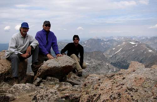
![On the Summit!]() On the summit! - Took this one with the aid of my Gorillapod. Looking NW. The Cirque of the Towers is just to the right of Chris' shoulder.
On the summit! - Took this one with the aid of my Gorillapod. Looking NW. The Cirque of the Towers is just to the right of Chris' shoulder.
Ironically, the other climbers were the same group we’d encountered two day’s prior. They were the Gans Family of Lander and the father, John, was the big cheese at NOLS in Lander. Spent some time talking to them and also added a new summit register as jimmyjay had suggested. I wish I had brought something to put it in as the nalgene bottle that was there was a bit small for the task. I think a welder’s Rod Guard tube would have worked great. Next time.
![The Cirque of the Towers..]() Cirque of the Towers from the Summit - Haystack Mtn in foreground with Black Joe Lake below. Jackass Pass in center with the Cirque of the Towers above.
Cirque of the Towers from the Summit - Haystack Mtn in foreground with Black Joe Lake below. Jackass Pass in center with the Cirque of the Towers above.![Little El Capitan, 12,825]() Little El Capitan - The Range stretches NW with Lizard Head Peak left of center on the horizon. Note the cracks in the face of Little El Capitan.
Little El Capitan - The Range stretches NW with Lizard Head Peak left of center on the horizon. Note the cracks in the face of Little El Capitan.![Deep Creek Lakes]() Looking NNE from wind River Peak - Wind River Glacier with the Deep Creek Lakes and the North Fork of the Popo Agie beyond. All the climbers we encountered came up "The Ramp" in the far right of this shot.
Looking NNE from wind River Peak - Wind River Glacier with the Deep Creek Lakes and the North Fork of the Popo Agie beyond. All the climbers we encountered came up "The Ramp" in the far right of this shot.
The views from the summit were spectacular! Wind River Peak towers above all in the Southern Winds! After an hour, we headed down, taking a short break just below the top, where we found cell service.
![Old man resting]() Me catching a little rest - This rock looked pretty inviting. ~ Photo by Chris Reed
Me catching a little rest - This rock looked pretty inviting. ~ Photo by Chris Reed![The human antennae]() The Human Antennae - We found no cell service on the summit but had a good signal just below the two snowfields. Chris searching for service.
The Human Antennae - We found no cell service on the summit but had a good signal just below the two snowfields. Chris searching for service.![Shelter from the storm]() Shelter from the storm-Wind River Peak - Someone made a little wall underneath this low, rock overhang. I'm glad we didn't feel the need to climb in there.
Shelter from the storm-Wind River Peak - Someone made a little wall underneath this low, rock overhang. I'm glad we didn't feel the need to climb in there.
We took a more easterly route down to avoid the tedium of the rocks. Along the way Marc and I spotted this shelter. Thankfully, we didn’t need to use it. Replenished our water from the snowfield and made our way back down in a light rain.
This time we didn’t lose the trail and upon reaching the junction, we figured out why we had lost it. On the way up it was impossible to see that the trail made a hard right, through some willows and crossed the creek. On the way down it was plain as day.
![Our route on Wind River Peak]() Red=ascent, Blue= descent variations
Red=ascent, Blue= descent variations
Got back to camp at 4:30 and crashed. Ten hours on the trail, ten miles of hiking plus 3,000 elevation gain and loss did me in. I must be gettin’ old. Lucky for me, Chris and Marc did the chores and Marc made dinner.
Thursday
Another do nothing day after the rigors of Wind River Peak. Washed clothes, ourselves and had a hot lunch. I got ambitious and decided to hike to the south end of the lake to check it out and do a little fishing.
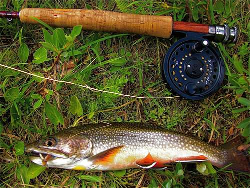
![Brook Trout]() Brook Trout - "Cooked" this one a bit to give it the feel of a painting ~ The outfit is an LL Bean 9', 6 piece, 5wt rod, paired with a Scientific Anglers, System 2 reel.
Brook Trout - "Cooked" this one a bit to give it the feel of a painting ~ The outfit is an LL Bean 9', 6 piece, 5wt rod, paired with a Scientific Anglers, System 2 reel.![Columbine]() Columbine in the rockfall - Worked at this one using the Gorillapod, didn't realize there was an insect in it. Most of the Columbines we saw were white like this one.
Columbine in the rockfall - Worked at this one using the Gorillapod, didn't realize there was an insect in it. Most of the Columbines we saw were white like this one.![Wind River Peak]() Wind River Peak over Mountain Sheep Lake - From the south end of the lake on our last day.
Wind River Peak over Mountain Sheep Lake - From the south end of the lake on our last day.
Caught quite a few and it was fun for awhile, but all were brooks, no sign of any goldens.
The inlet stream flowed under the giant rockfall coming from an unnamed lake above. I could hear it, but it flowed unseen, beneath the rocks. Reminded me of the creek that flows underneath the Boulderfield on Longs Peak.
Got back to camp just as Chris was putting the finishing touches on an afternoon snack of mashed potatoes. Timing is everything! Kicked back for the rest of the evening, putting off packing till morning since we weren’t planning on leaving early. Noticed that the barometer was dropping and wondered what weather might be in store for us. A little rain fell before dawn but it was another “dry rain”.
Friday
![Tayo Creek crossing]() Crossing Tayo Creek - The most "treacherous" crossing of the trip. My much repaired chair was no longer foldable and one more nights use was all I needed out of it. ~ Photo by Chris Reed
Crossing Tayo Creek - The most "treacherous" crossing of the trip. My much repaired chair was no longer foldable and one more nights use was all I needed out of it. ~ Photo by Chris Reed
We got on the trail at 10 and crossed Tayo Creek without incident. My “recliner backpack” performed flawlessly. The four mile hike to Tayo Park was a piece of cake compared to what had gone before.
![Bill crossing the.....]() Bill crossing the Popo Agie at Tayo Park - In three trips to the Winds we've been lucky and had nothing but easy, low water crossings. ~ Photo by Chris Reed
Bill crossing the Popo Agie at Tayo Park - In three trips to the Winds we've been lucky and had nothing but easy, low water crossings. ~ Photo by Chris Reed
The crossing of the Popo Agie at Tayo Park caused us no trouble as the flow was quite low. Took a break on the other side then kicked it into gear at 12:45 on our way up the trail to Sweetwater Gap. About the time we reached the Gap, a light rain began to fall.
![Break at the Gap]() Seeking shelter at the Sweetwater Gap - Marc seeks refuge from the mosquitoes while Chris ponders the Earthwalk Map.
Seeking shelter at the Sweetwater Gap - Marc seeks refuge from the mosquitoes while Chris ponders the Earthwalk Map.
Took a break out of the rain and decided to camp just below the Gap as soon as we could find a suitable spot. Once we found one we quickly set up camp and had a late lunch. We’d all brought packets of tuna and I had a bunch of those fastfood mayonaise squeeze-tubes. We’re talking a lot of tuna! Once we picked the blue mold spots off the remaining pita bread it was an unbelievably delicious feast. Easily the most filling meal of the entire trip. We spent our last night in the wilderness trying to keep a fire going in an outrageous downpour, sipping the last of Chris’s whiskey and havin’ one hell of a good time. When the flasks were emptied, we crawled into our tents as the day’s last light faded.
Saturday
Got up at 7:30, packed up and got on the trail by 10, beginning our six mile hike to the TH. Saw our only glimpse of wildlife, a spike mule deer, in the first couple miles. Ran into two horsemen who were on their way to the Gap and the lake that they thought was there. Also ran into a couple that told us they were through-hiking to Trail Lake, at the northern end of the Winds. We wished them well.
At 1:20 pm, we climbed the hill from Larsen Creek and reached the TH, seven days, almost to the minute from when we’d first arrived. The 4Runner was the only vehicle in sight.
![At the Trailhead]() Ice cold trailhead beer-as good as it gets! - The great experiment was a success!! After seven days, the cooler still held ice, thanks to magic of dry ice. It was a beautiful moment.
Ice cold trailhead beer-as good as it gets! - The great experiment was a success!! After seven days, the cooler still held ice, thanks to magic of dry ice. It was a beautiful moment.
It would be a gross understatement to say that we weren’t delighted to find that the cooler still held ice and......cold beer.
After 23 miles of dirt we hit Hwy 28, listening to Neutral Milk Hotel’s “Two Headed Boy” and cruised down the hill to Lander. Rolled into town around 3:30 and after securing a fresh supply of scotch and beer, checked into the Pronghorn Motel. Had a nice dinner on the patio at the Gannett Grill and spent the remainder of the evening next door at the Lander Bar. Interesting place, that Lander Bar. Drank a lot of beer and played a lot of pool before crossing that Popo Agie one more time.
I surely do love them Wind Rivers!


Comments
Post a Comment