
|
|
Route |
|---|---|
|
|
46.38330°N / 13.85000°E |
|
|
Hiking and scramble |
|
|
One to two days |
|
|
Walk-up and easy climbing |
|
|
Approach
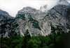
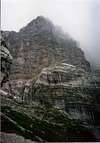
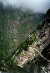
Zadnjica is quite short (3.5km) subsidiary to famous Trenta valley. It begins at Trenta village and opens towards east. It gradually rises till its end at Planja (1000m). Bottom is mostly forested and there are few meadows. Around the valley is some of the most dramatic scenery in Julian Alps. The cliffs of Pihavec (2414m), Triglav (2864m), Kanjavec (2568m), Vrsac (2194m) and Ozebnik (2083m), which fall into dark depths of Zadnjica have no match in Julian Alps. They create amazing wall around the valley, which culminates with highest face of Julian Alps, that of Kanjavec, which is 1500m high! In the valley is dark and subdued atmosphere because walls around are letting very little sunshine in. End of valley is reached by road, which is closed to traffic 2km above the Trenta village.
From the valley there are two possibilities to climb Triglav. One will take you via Dolic pass and hut while the other ascends towards Luknja pass where it joins Bambergov Pot trail from Vrata valley
a.)Zadnjica - Koca na Dolicu hut - Triglav
You start walking from parking place on the marked route for the Kanjavec and Triglav. First you walk on a nice macadam road and soon you come to the crossing (when the macadam route ends) where you turn left and lead the signposts for Koca na Dolicu (hut). On the right another route lead you to the Zasavska koca na Prehodavcih (hut).
Now you have two possiblities for reaching Koca na Dolicu (hut): You can take a short one and ascend over steep passages over Komar or you go around and reach Koca na Dolicu (hut) over a nice old military way. Both possiblities will show you beautiful view on Triglav and other mountains.
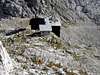
From the hut path descends little bit to the place where old hut stood and than turn’s right. It ascends in many sharp bends towards huge gradual slopes bellow Triglav. Long, gradual ascent over them takes us to the bottom of Triglav’s cliffs. On the left you can see the huge Morbegna ruins (2500m), Italian barracks from WW I. For decades it still resists destructive work of time quite well and can offer precious shelter in case of a sudden storm.
Here we are joined by Bambergova pot trail from Aljazev Dom hut in Vrata valley. Path turns right and climbs over scree slopes bellow cliffs of Triglav. When we reach them path, secured with fixed ropes and pegs, climbs steeply to the right over the bottom of red couloir till it reaches Triglavska skrbina (2659m). Path than turns left and climbs southern Triglav’s ridge all the way to the top.
 |  |  |  |  |
b.) Zadnjica - Luknja - Bambergova route - Triglav
You start walking from parking place on the marked route for the Kanjavec and Triglav. First you walk on a nice macadam road and soon you come to the crossing (when the macadam route ends) where you turn left and lead the signposts for Luknja pass, 1758m. You keep walking over a nice old military way and all the time follow and lead the signposts for Luknja pass and Bambergova pot. Finnaly you come on Luknja pass where from NE side comes route from Vrata valley.
Here starts Bambergova route.
Our path turns right towards steep cliff. We are helped by secure pegs and fixed ropes, without them this section would be pure alpinism. After the cliff ascent flattens little bit but continues to be steep. Path is heading up mostly right of ridge, but on few places it touches the edge of Triglav’s north place, huge abyss opens. Sides are very exposed and steep, secured only where it is necessary so this is only for experienced mountaineers.
After 2.30h slope flattens little bit going over larger horizontal section only to climb again steeply behind it. On the top of this section hardest part is behind you. View opens on amazing towers and couloirs of Triglav’s north face, especially on nearby “Sfinga”.
From here it descends towards sharp pass and than climbs gradually on the edge of Plemenice. Plemenice are large plateau on the edge of Triglavs summit pyramid. Path leads us along large plateau’s, above Sfinga. After that turns right and ascends on a higher plateau, where we are close to Morbegna barracks (2500m). Here we join the path from Dolic hut. It continues to climbs over scree slopes bellow cliffs of Triglav. When we reach them path, secured with fixed ropes and pegs, climbs steeply to the right over the bottom of red couloir till it reaches Triglavska skrbina (2659m). Path than turns left and climbs southern Triglav’s ridge all the way to the top.
 |  |
Essential Gear
Good hiking shoes, rope, helmet.
Miscellaneous Info
If you have information about this route that doesn't pertain to any of the other sections, please add it here.