Page Type Page Type: Mountain/Rock
Location Lat/Lon: 46.71000°N / 12.44000°E
Additional Information Elevation: 7851 ft / 2393 m
Sign the Climber's Log

Overview


Geographical Classification : Eastern Alps > Carnic Alps > Carnic Alps Main Ridge (West) > Zenzerspitze
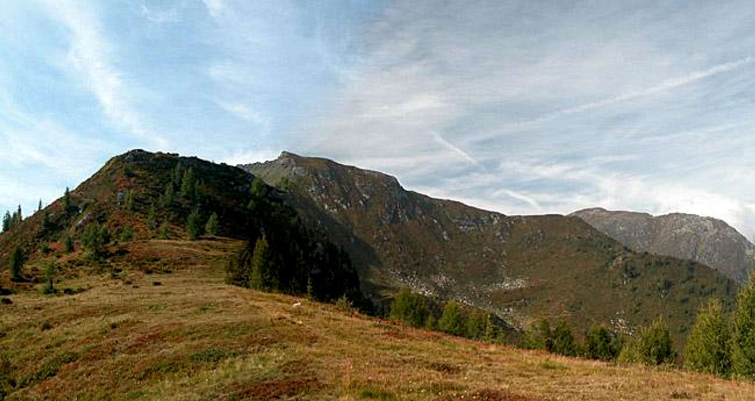
Zenzerspitze photo_id=120109

Though geographically Zenzerspitze belongs to the Carnic Alps Main Ridge it is located on one of the northern side ridges. Actually the Zenzerspitze ridge is the first one counted coming from west and it commands views down into the Lesachtal and Pustertal Valleys that are comparable to those from the westernmost Carnic Alps summit, Helm (Monte Elmo). It is a very popular hiking and ski tour destination, often climbed in conjunction with Hollbrucker Spitze, Hornischegg and Füllhorn to its south-west.

The mountain must have been of strategic importance during World War I, though which importance that might have been, I'm at a loss to explain. Surely enough the location at the junction of two valleys was important but how can you explain the tiny WW I position, which has "windows" just wide enough to put a rifle barrel through? The enemy must have been real close to be killed from there. I assume the position was meant to secure a supply trail to Hochgränten Pass (located to the south between Hollbrucker Spitze and Demut / La Mutta), a heavily fought for passage in the main ridge. There are two trails near the top - the main one cutting through the eastern slope of Zenzerspitze while the eastern one makes for the summit itself. This latter trail is rather overgrown so the best way would be to take the main trail and climb Zenzerspitze from the south across a beautiful grass ridge. Also two ascent routes lead to the summit, both starting at the village of Hollbruck in the Tyrol Gailtal Valley. One takes the northern ridge approach across the Eggwiesen Meadows, the other heading south through Hollbrucker Tal to climb the mountain along its southern ridge. Both approaches can be easily combined with an ascent of Hollbrucker Spitze. A third route starts at Leckfeldalm, which can be reached by car and heads along the main ridge starting at Füllhorn.

Getting There


Western Main RidgeWest Central Main RidgeCrode dei LongerinPeralba - Chiadenis - AvanzaEast Central Main RidgeBiegengebirgeKellerwand - Hohe WarteMooskofel GroupRinaldo Group
Interactive map of the western part of the Carnic Alps Main Ridge. The numbers refer to the respective subgroups as given on the Carnic Alps Main Ridge (West) Page. Click on them to go to the subgroup description. Zenzerspitze is located at the tip of the "1" of subgroup 1.

The best starting point for an ascent of Zenzerspitze is the village of Hollbruck south of the Tyrol Gailtal Valley. The village is a small, but touristy hamlet, which can be reached by a side road from Kartitsch.

From the West (Brenner Motorway A22)
Leave the Brenner Motorway near Brixen / Bressanone and follow SS49 to the east through Pustertal / Val Pusteria. To the east of Innichen / San Candido you cross the Austrian-Italian border and follow the road (now B100) to Tassenbach. Turn right (south-east) here onto B111, which you follow in direction Kartitsch. Shortly before you reach Kartitsch a side road turns off to the right, which will lead you to Hollbruck. Park your car in the village, where two of the ascent routes start. To reach Leckfeldalm you already have to turn off at Panzendorf between Sillian and the intersection to B111. A paved road leads to the alp.

From the North
There are two possible roads:
  • From Kitzbühel over B108 through the Felbertauern Tunnel to Lienz, then southwest to Tassenbach (B100), where you turn on to B111 east into the Tyrol Gailtal. For Leckfeldalm, take B100 just a little longer to Panzendorf, where you turn off south.
  • From Salzburg along motorway A10 to Spittal. Turn west on B100 to Oberdrauburg, there south to Kötschach-Mauthen were you turn east on B111. You need to go through the whole Lesachtal Valley to reach Kartitsch. Shortly afterwards turn to the left to Hollbruck. For Leckfelder Alm, go through Kartitsch until you reach the intersection with B100. Turn left (west) until you reach Panzendorf.

From the South (Udine)
Take Motorway A23 to the exit Camia Tolmezzo. Follow SS52 north to Tolmezzo where you turn onto SS52 bis. This leads to Plöckenpass, where it crosses the Austrian-Italian border. In Austria the road turns into B100 and at Kötschach-Mauthen you have to turn east on B111 into Lesachtal Valley. Again, go on through the whole valley to Kartitsch or on to Tassenbach and Panzendorf.

Zenzerspitze photo_id=120121


Zenzerspitze photo_id=112675Zenzerspitze photo_id=117881Zenzerspitze photo_id=117881

Red Tape


There's no red tape here. When hiking along the main ridge be sure to bring your ID since it is the border between Austria and Italy. Adhere to the obvious: The slopes of all the mountains of the area are used for cattle and sheep grazing. Please close all gates - or leave them as you find them.

Also you are asked to keep dogs on leash or at least keep a close eye on them. There are lots of marmots out there and sheep, of course. On the Austrian side of the ridge I have seen signs to use the leashes wherever sheep are around.

Camping near the border certainly is not the best of ideas. There are several huts in the area (also a bivouac) so you should stay there. In case you definitely want to camp outside go to the huts and inform the proprietors. They'll turn a blind eye, maybe charge a couple of bucks for the use of the restrooms. See below for the link to the Hut overview as given on the Carnic Alps Main Page. Moreover hay cabins, which you find in the upper parts near the summit and across the Eggwiesen Alp, can serve as shelters, though they won't keep the wind outside.

The picture to the right shows the blue monkshood, a poisonous plant which has been used for ages in pharmaceuticals. It is a close relative to the common larkspur.
 Zenzerspitze photo_id=120128

When To Climb


Zenzerspitze can be climbed all year round. The hiking season is May through October but winter ascents are possible too. The trails from Hollbruck are both very steep so in snowy condition bring skis or snowshoes. The mountain is a popular ski tour destination, especially when seen in conjunction with the main ridge summits. Often a round tour Sillian - Helm - Hollbrucker Spitze - Zenzerspitze - Hollbruck - Sillian is done, but also the eastern loop Hollbruck - Zenzerspitze - Hollbrucker Spitze - Cima Frugnoni - Kartitsch - Hollbruck.

Accommodation


Camping on the Austian - Italian border might not be the best idea. Near the refuges you shouldn't have problems, but ask the proprietors. The nearest ones are Helmhaus and Sillianer Hütte. See the Mountain Huts & Refuges Section on the Carnic Alps Main Page for telephone numbers.

In most of the villages of Hochpustertal, Tyrol Gailtal and Lesachtal you can find small campgrounds, which are often associated with inns or hotels. If you are looking for hotel rooms or apartments follow one of the links below

Weather Conditions


Being the southernmost parts of Austria the states of Carinthia and East Tyrol show much better weather than the rest of the country. Still, the Carnic Alp Main Ridge is a main weather divide, so that rapid changes can occur.

You can keep yourself informed about the weather by one of the links below

Maps 'n' Books


Maps
I have been using maps by Kompass Verlag, which are very good for the hiking trails though they don't show ALL the relevant summits of the area.
  • Lienzer Dolomiten / Lesachtal
    1:50000
    Kompass Map WK47
    Kompass Verlag
    ISBN: 3-85491-053-3
  • Sesto
    1:25000
    Tabacco Map 10
    Editione Tabacco

As for books, please look at the corresponding section of the Carnic Alps page.

External Links

  • Austrian Map online
    Online digital maps of Austria (OEK 50, OEK 200 and OEK 500) by the BEV (Bundesamt für Eich- und Vermessungswesen) - in German


Children

Children

Children refers to the set of objects that logically fall under a given object. For example, the Aconcagua mountain page is a child of the 'Aconcagua Group' and the 'Seven Summits.' The Aconcagua mountain itself has many routes, photos, and trip reports as children.