
-
 4935 Hits
-
 73.06% Score
-
 3 Votes
|
|
Route |
|---|---|
|
|
46.38548°N / 13.38598°E |
|
|
Hiking |
|
|
Spring, Summer, Fall, Winter |
|
|
Most of a day |
|
|
Medium hard walk-up |
|
|
Rating The Tour (With Hiking Standards)
0. General. From 1120 m (or, if using cable-car from 1850 m) to 2324 m, slopes orientation east and south. Well marked paths, the summit ridge narrow on a few places. Gear: Only good shoes and poles.
1. Effort: 1300 meters of altitude, 4 hours 30 minutes.
2. Power: 1 - no difficulties (only walk-up).
3. Psyche: 2 - easy, a few steep and a bit exposed sections below the top.
4. Orientation: 1 - no difficulties (taka care of marks on the high plateau).
Overview
When you are on the northen high karst plateau of Kanin, it is not necessary only to go on the highest summits of the main ridge. Žrd / Monte Sart is a good alternative, a fantastic panoramic point and a not hard, although a quite long hike. It can be done in almost any season, in good conditions also in winter and with skis.
Route Description

Above Sella Nevea
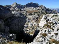
You start the tour on Sella Nevea, on the big parking place by the lower station of Kanin cable-car. Over the ski slopes (better than by the marked path) you ascend below the imposing wall of Bela peč on the high plateau, where Rif. Gilberti stands. This part (1 h 45 min) can be done also with cable-car. From the hut you turn right, towards the West, and take the path No. 632. It goes first by the nearby valley, then it ascends 150 meters on the saddle below Bela peč. Here, by ruins of an old stone building, the view on Žrd / Monte Sart opens.
Zrd from Sella Bela pec
From the saddle below Bela peč (you have only 15 minutes on its top) you continue westwards by a well marked path, which in its first part doesn't lose any altitude. But it uses ledges and passages, which enter a few ravines, so you're asking yourself if it wouldn't be better to descent already from the saddle those 50 meters into a shallow valley, which goes directly towards Peravo saddle. So, after the crossroads (the left path goes up towards Kanin) our path descends down into a shallow meadow and finally ascends again those 50 meters to Peravo saddle, where bivouac Marussich stands, 2040 m.

On the summit ridge
From the bivouac the marked path on Žrd / Monte Sart first ascends in a few turns up below the summit of Vrh Grubja / Picco di Grubia, then crosses its northern slopes on a grassy saddle below the eastern summit of Žrd / Monte Sart. There the better marked 'Via Alta Resiana' continues over the southern slopes, so we must deter right and by a tiny path ascend the eastern summit by its narrow ridge. The path is more and more panoramic and we are soon on the first summit. There you need to decide whether to go another 20 minutes on the only 3 meters higher western summit. If yes, you scramble all the time by top of the ridge, overcome the middle summit and finaly reach the so desired goal. 1 h 30 min from the bivouac.