
|
|
Mountain/Rock |
|---|---|
|
|
47.74247°N / 13.35212°E |
|
|
Hiking, Skiing |
|
|
Spring, Summer, Fall, Winter |
|
|
4993 ft / 1522 m |
|
|
Overview
Zwoelferhorn is a 1.522m high mountain. It is part of the Osterhorngruppe in the Austrian district of Salzburg. From the top of Zwoelferhorn you have a perfect view to the area of Salzkammergut and its several lakes. There is as well a perfect view to the other mountains of the Osterhorn-Group, the Gosaukamm, Dachstein and the Tennengebirge.There are several ways from St. Gilgen (545m) to Zwoelferhorn. The main way is Nr. 855. You go up to Weiß·and and Sausteigalm, 1.110m. At Sausteigalm you can go right along the downhill skiing track or left on the Elfersteig. On the left way you pass Elferstein (1.376m) and cross the other way to the summit again. From St.Gilgen to Zwoelferhorn it takes about 2.30 hours to the summit.
From the parking at Tiefbrunnau (797m) you can take way Nr. 854 to Schafbachalm, on to Pillsteinalm and Zwoelferhorn. It takes about 2 hours to the summit.

Skiing area
You can also take the Zwoelferhorn (cable car) up to the summit. This is a very special ride because the cable car is very old. (no fear: it is perfectly serviced)
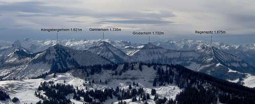
Views from the summit

Schafberg, 1.782m

Wolfgang Lake

Schmittenstein, 1.695m
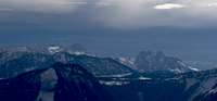
Dachstein and Gosaukamm
Getting There
By public transport: there are busses from Salzburg, Strobl, Mondsee, Bad Ischl and Abersee to St. Gilgen.By car: about 30 kilometres from Salzburg and 24 kilometres from Bad Ischl on the Wolfgangsee-street. From A1-highway exit Mondsee 18 kilometres.
When to go there
You can hike Zwoelferhorn from late spring to late autumn. In winter you can also make ski-tours to the summit. You can reach the top by cable-car and go downhill skiing in winter.Other Mountains in the area
Wieslerhorn 1.603mRegenspitz 1.675m
Schmittenstein 1.695m
Gennerhorn 1.735m
Osterhorn 1.746m
Hoher Zinken 1.764m
Schafberg 1.782m
Osterhorn Group
Maps
Mayr Hiking Guide, Nr. 76Wolfgangsee- St Gilgen, Strobl/Postalm, St. Wolfgang
Scale: 1:35.000
Freytag & Berndt
WK 392 Tennengebirge-Lammertal-Osterhorngruppe
ISBN: 385084739X
Scale: 1:50.000
External Links
Zwoelferhorn (German only)Wolfgangsee