Rainier seen from Prairie Peak between Corvallis and Florence, right about 200 miles.

Climbing, hiking, mountaineering forum
http://www.summitpost.org/phpBB3/
https://www.summitpost.org/phpBB3/longest-lines-of-sight-photographed-t44409-135.html
calebEOC wrote:Rainier seen from Prairie Peak between Corvallis and Florence, right about 200 miles.
Iron Hiker wrote:calebEOC wrote:Rainier seen from Prairie Peak between Corvallis and Florence, right about 200 miles.
Pretty neat pic. I do think, however, that this is St. Helens standing out more since it's closer by 50 miles (149 miles away from Prairie), and seems to have that "right shape." Paradoxically, this view has Rainier and St. Helens NEXT to each other, but I cannot make out anything like Rainier to St. Helens' left (cloud interference). Nevertheless, if Rainier is visible, this would be one of the longest photo shots anywhere in the lower 48 that I've seen!

Mr Leghorn wrote:Anyone know what the distance between St George, UT and the San Francisco Peaks is?
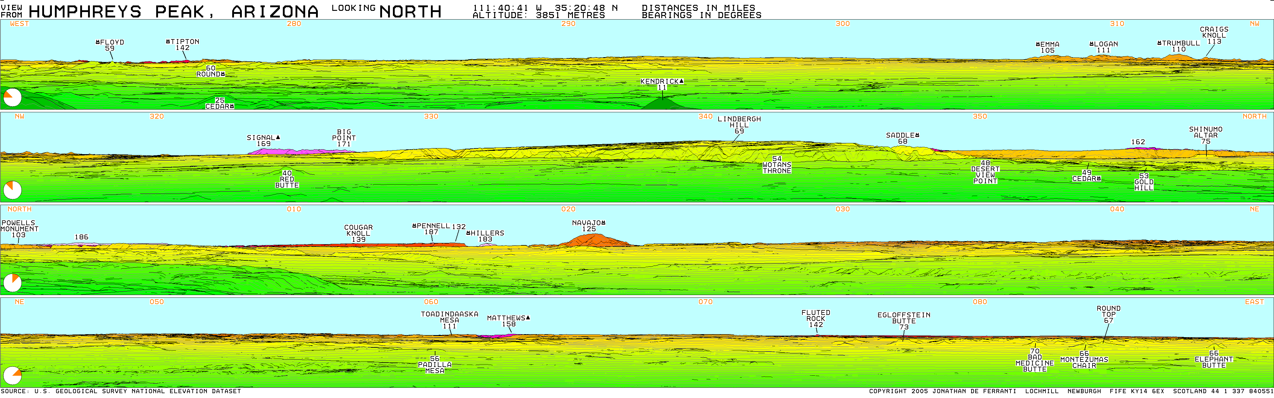
Mr Leghorn wrote:I took a photo today of Navajo Mt and if you look west from it on the horizon you can just make out a low white blotch that is Mount Hillers. It is 183 miles away, according to:
http://www.viewfinderpanoramas.org/pano ... REYS-N.gif
http://www.summitpost.org/mount-hillers ... rey/693491
Use the original above to see Hillers. You can't actually see it in the image below.
BTW, I noticed someone way back in the thread saying Phoenix, AZ to Humphrey is 250 miles. It is not, it is maybe 135 miles from The Peaks to Sky Harbor airport.
butitsadryheat wrote:Day Hiker wrote:Here is a simulated view, looking northeast from Bakersfield, CA on a clear day. The angle of view is 90 degress, spanning from north to east. The colors are by elevation only, not actual Earth colors.
Hey Day Hiker
Driving in this morning, I saw even further to the north than this shot. I was a bit further west, and maybe a little higher in elevation by about 20 or 30 feet, and was able to see a large snow covered peak on the edge of my line of sight. Any idea what it was? It was north of Hengst and Florence, and kind of rounded, but completely covered in snow, so it had to be higher levation. Incredibly clear today with the winds from this storm approaching


