The new PeakFinder website is online!
http://www.peakfinder.org shows from any location a 360° panoramic view with the names of all mountains and peaks.
It's designed for mountain lovers to already prepare at home for the next trip. Explore 360° panoramic views from any peak. They can be printed, taken with you to your hike or send (pdf) to friends.
I hope you like the new website. I am looking forward to your feedback.
Best regards
Fabio
PeakFinder: New website with 360° panoramic views online
14 posts
Page 1 of 1
- The following user would like to thank PeakFinder for this post
Bark Eater, Diego Sahagún, Fletch, Iron Hiker, SzaniUherkovich
-

calebEOC - Posts: 518
- Joined: Tue Jun 21, 2005 3:47 pm
- Thanked: 0 time in 0 post
Re: PeakFinder: New website with 360° panoramic views online
Wow this is pretty cool
-

Iron Hiker - Posts: 42
- Joined: Thu Mar 22, 2001 1:00 pm
- Thanked: 3 times in 2 posts
Re: PeakFinder: New website with 360° panoramic views online
I've had the iPod Touch app of this program for a couple years. It's pretty neat, and I've used it to good profit.
A couple suggestions for improvement:
1. There should be some way to show the ocean if the peak is close to it. The intro panorama from Mount Woodson does not show the Pacific at all (nor does it show Clemente and Catalina Islands).
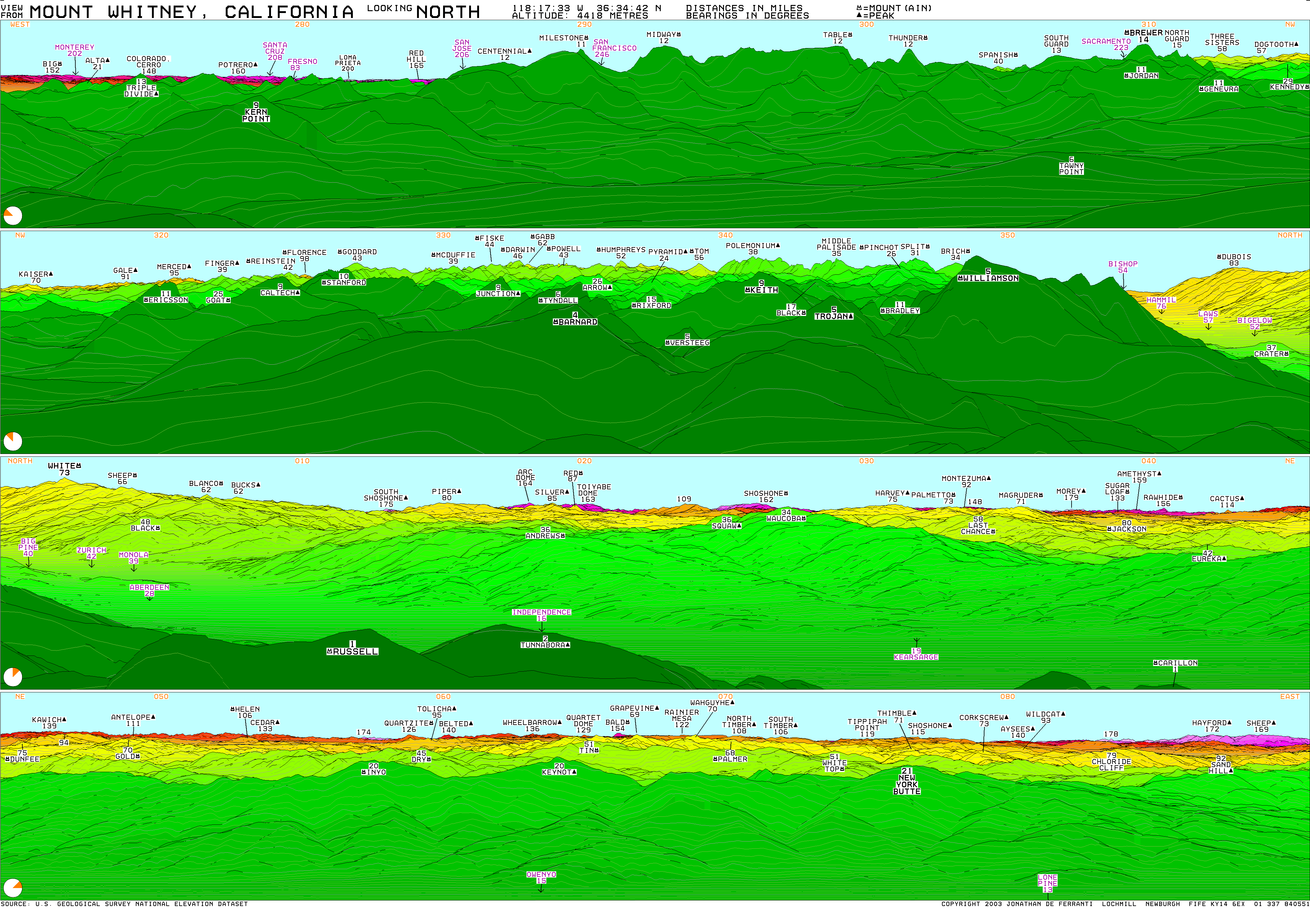
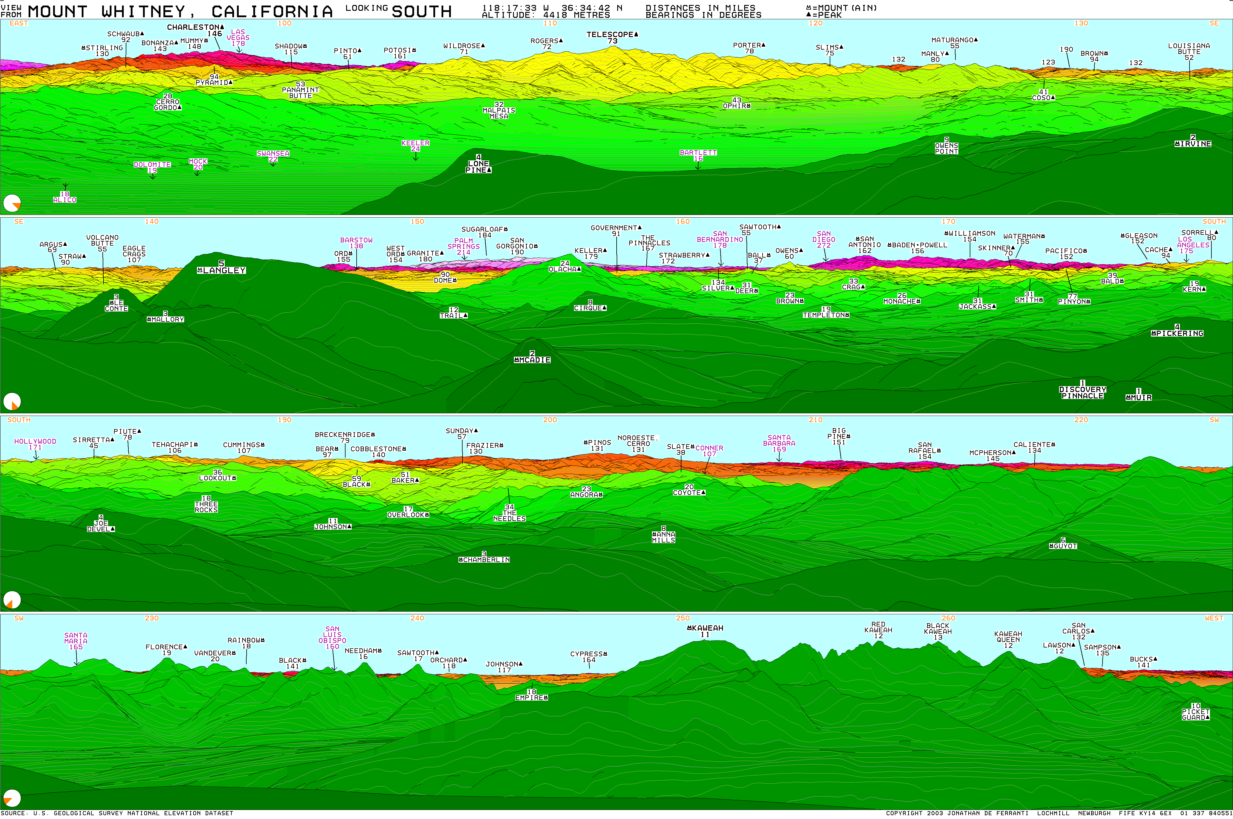
2. The views do not go to their maximum extent. For example, check out the summit panorama from Mount Whitney and then compare it with the one Jonathan de Ferranti has generated at Viewfinder Panoramas:
http://www.viewfinderpanoramas.org/panoramas/AME/WHITNEY-N.gif
http://www.viewfinderpanoramas.org/panoramas/AME/WHITNEY-S.gif
Everything over about 125 miles out does not show up on the PeakFinder program, most notably Charleston Peak, San Gorgonio Mountain, and Mount San Antonio (Mount Baldy). I saw Charleston and Baldy myself from Whitney 2 yrs ago (and MAYBE Gorgonio). Granted, this type of view doesn't show up most of the time, but for those of us devoted to long lines of sight, it can be a little frustrating not seeing these distant peaks on the software.
http://www.heywhatsthat.com provides a good way to see on a map what is visible from the top of a peak. It remains to convert that to a "landscape format" much like what this program and Jonathan has done......
It is my hope that perhaps these issues can be further addressed, but substantially I greatly approve of this software! Thanks for creating it.
A couple suggestions for improvement:
1. There should be some way to show the ocean if the peak is close to it. The intro panorama from Mount Woodson does not show the Pacific at all (nor does it show Clemente and Catalina Islands).
2. The views do not go to their maximum extent. For example, check out the summit panorama from Mount Whitney and then compare it with the one Jonathan de Ferranti has generated at Viewfinder Panoramas:
http://www.viewfinderpanoramas.org/panoramas/AME/WHITNEY-N.gif
http://www.viewfinderpanoramas.org/panoramas/AME/WHITNEY-S.gif
Everything over about 125 miles out does not show up on the PeakFinder program, most notably Charleston Peak, San Gorgonio Mountain, and Mount San Antonio (Mount Baldy). I saw Charleston and Baldy myself from Whitney 2 yrs ago (and MAYBE Gorgonio). Granted, this type of view doesn't show up most of the time, but for those of us devoted to long lines of sight, it can be a little frustrating not seeing these distant peaks on the software.
http://www.heywhatsthat.com provides a good way to see on a map what is visible from the top of a peak. It remains to convert that to a "landscape format" much like what this program and Jonathan has done......
It is my hope that perhaps these issues can be further addressed, but substantially I greatly approve of this software! Thanks for creating it.
-

Josh Lewis - Posts: 3414
- Joined: Thu Jan 06, 2011 11:12 pm
- Thanked: 1111 times in 679 posts
Re: PeakFinder: New website with 360° panoramic views online
Impressive. I'm not quite sure how this was figured out. My suggestion would be to allow display of the real satellite imagery off of something like Google Earth so that I could make out certain details and easily identify things in real life.
-

PeakFinder - Posts: 5
- Joined: Fri Sep 21, 2012 12:44 pm
- Thanked: 7 times in 3 posts
Re: PeakFinder: New website with 360° panoramic views online
@Iron Hiker: Thanks a lot for your reply. That helped a lot to improve PeakFinder.
I'll try to add more details like lakes and the ocean in future versions.
Thanks a lot for this detailed information. You're completely right. There was an error in my code that stopped the calculation to early. I fixed this error now. I also added another zoomlevel for more details and increased the maximum with to 200 miles.
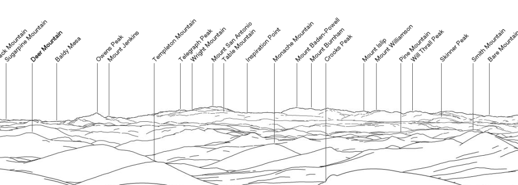
Here is an example of the view from Mount Whitney towards Mount San Antonio:
http://www.peakfinder.org/?lat=36.5796& ... =7&dir=167
Iron Hiker wrote:1. There should be some way to show the ocean if the peak is close to it. The intro panorama from Mount Woodson does not show the Pacific at all (nor does it show Clemente and Catalina Islands).
I'll try to add more details like lakes and the ocean in future versions.
Iron Hiker wrote:2. The views do not go to their maximum extent. For example, check out the summit panorama from Mount Whitney and then compare it with the one Jonathan de Ferranti has generated at Viewfinder Panoramas:
http://www.viewfinderpanoramas.org/panoramas/AME/WHITNEY-N.gif
http://www.viewfinderpanoramas.org/panoramas/AME/WHITNEY-S.gif
Everything over about 125 miles out does not show up on the PeakFinder program, most notably Charleston Peak, San Gorgonio Mountain, and Mount San Antonio (Mount Baldy). I saw Charleston and Baldy myself from Whitney 2 yrs ago (and MAYBE Gorgonio). Granted, this type of view doesn't show up most of the time, but for those of us devoted to long lines of sight, it can be a little frustrating not seeing these distant peaks on the software.
Thanks a lot for this detailed information. You're completely right. There was an error in my code that stopped the calculation to early. I fixed this error now. I also added another zoomlevel for more details and increased the maximum with to 200 miles.
Here is an example of the view from Mount Whitney towards Mount San Antonio:
http://www.peakfinder.org/?lat=36.5796& ... =7&dir=167
-

moonspots - Posts: 175
- Joined: Mon Jun 19, 2006 2:30 am
- Thanked: 6 times in 6 posts
Re: PeakFinder: New website with 360° panoramic views online
calebEOC wrote:Wow this is pretty cool
Yes, excellent!
Thank you for the effort, and especially the results.
I can't imagine how this is/can be done.
One question, Is there a way to "double click" on a distant (un-named) peak and go there?
This is great, especially since it can be used on iphone and android platforms.
-
PeakFinder - Posts: 5
- Joined: Fri Sep 21, 2012 12:44 pm
- Thanked: 7 times in 3 posts
Re: PeakFinder: New website with 360° panoramic views online
moonspots wrote:Yes, excellent!
Thank you for the effort, and especially the results.
Great that you like it.
moonspots wrote:One question, Is there a way to "double click" on a distant (un-named) peak and go there?
If the peak is unknown this doesn't work. But if the peak is in the database but not shown with a label (because there is not enough space) you can use the 'digital binoculars' and then press the little 'walking man' on the info popup:
-
Iron Hiker - Posts: 42
- Joined: Thu Mar 22, 2001 1:00 pm
- Thanked: 3 times in 2 posts
Re: PeakFinder: New website with 360° panoramic views online
PeakFinder wrote:@Iron Hiker: Thanks a lot for your reply. That helped a lot to improve PeakFinder.Iron Hiker wrote:1. There should be some way to show the ocean if the peak is close to it. The intro panorama from Mount Woodson does not show the Pacific at all (nor does it show Clemente and Catalina Islands).
I'll try to add more details like lakes and the ocean in future versions.Iron Hiker wrote:2. The views do not go to their maximum extent. For example, check out the summit panorama from Mount Whitney and then compare it with the one Jonathan de Ferranti has generated at Viewfinder Panoramas:
http://www.viewfinderpanoramas.org/panoramas/AME/WHITNEY-N.gif
http://www.viewfinderpanoramas.org/panoramas/AME/WHITNEY-S.gif
Everything over about 125 miles out does not show up on the PeakFinder program, most notably Charleston Peak, San Gorgonio Mountain, and Mount San Antonio (Mount Baldy). I saw Charleston and Baldy myself from Whitney 2 yrs ago (and MAYBE Gorgonio). Granted, this type of view doesn't show up most of the time, but for those of us devoted to long lines of sight, it can be a little frustrating not seeing these distant peaks on the software.
Thanks a lot for this detailed information. You're completely right. There was an error in my code that stopped the calculation to early. I fixed this error now. I also added another zoomlevel for more details and increased the maximum with to 200 miles.
Here is an example of the view from Mount Whitney towards Mount San Antonio:
http://www.peakfinder.org/?lat=36.5796& ... =7&dir=167
That's really great, thanks PeakFinder!
The 200-mile limit seems like a good boundary to stop at. Although, believe it or not, there ARE 200+ mile views from peaks like Mount Rainier, though not many more like that one (It's up to you)! Out East, I've found views no further than 150 miles so perhaps that can be the boundary for the Eastern USA.
Are you going to provide an update so my iPod Touch can have these latest changes? I've had PeakFinder installed on it for a while and would like to see this improvement on it (as of now the Whitney view is still the same old "limited" one on the iPod Touch app).
One more little thing with the web version: is there a way to change the line of sight distance to miles instead of kilometers? I can't currently seem to find an easy way of doing that......
If you'd like to see some discussion about long lines of sight as well as photos, here is a thread on that I began a few years ago:
longest-lines-of-sight-photographed-t44409.html
With these issues solved, this will be even more of a great go-to program for me for these summit views! Thanks again for providing this service.
-
PeakFinder - Posts: 5
- Joined: Fri Sep 21, 2012 12:44 pm
- Thanked: 7 times in 3 posts
Re: PeakFinder: New website with 360° panoramic views online
Iron Hiker wrote:The 200-mile limit seems like a good boundary to stop at. Although, believe it or not, there ARE 200+ mile views from peaks like Mount Rainier, though not many more like that one (It's up to you)! Out East, I've found views no further than 150 miles so perhaps that can be the boundary for the Eastern USA.
This is true. Here is a picture from Mount McKinley to Mount Sanford, a direct distance 370km (230 miles) http://www.viewfinderpanoramas.org/gallery/usa/sanford.html.
But for the moment I think the 200-mile limit is ok.
Iron Hiker wrote:Are you going to provide an update so my iPod Touch can have these latest changes? I've had PeakFinder installed on it for a while and would like to see this improvement on it (as of now the Whitney view is still the same old "limited" one on the iPod Touch app).
Sure. That update should be ready in November.
Iron Hiker wrote:One more little thing with the web version: is there a way to change the line of sight distance to miles instead of kilometers? I can't currently seem to find an easy way of doing that......
Thanks again for this hint. I just added the distance in miles to the webpage.
Best regards
Fabio
-
Iron Hiker - Posts: 42
- Joined: Thu Mar 22, 2001 1:00 pm
- Thanked: 3 times in 2 posts
Re: PeakFinder: New website with 360° panoramic views online
All very nice, Fabio.
I've already done a lot of looking around at the views on the website version. I just noticed that the coverage is larger on the site than on the mobile version, so that is especially welcome. Plenty of room for expansion and improvement, for sure!
What kind of data do you use for outside the USA? You are aware of Jonathan de Ferranti's long-term project for providing reliable terrain data for all the mountain areas of the world, I assume. I only ask this because it does seem a few areas have "less accurate" shapes of mountains, like Canada for example. I understand the data does best when you look on mountains from a distance rather than up close, but for Canada it still seems somewhat "approximate" as compared to USA views. That's just my impression......it's all very good, still.
Keep up the excellent work!
-
PeakFinder - Posts: 5
- Joined: Fri Sep 21, 2012 12:44 pm
- Thanked: 7 times in 3 posts
Re: PeakFinder: New website with 360° panoramic views online
Iron Hiker wrote:u going to provide an update so my iPod Touch can have these latest changes? I've had PeakFinder installed on it for a while and would like to see this improvement on it (as of now the Whitney view is still the same old "limited" one on the iPod Touch app).
PeakFinder 2.0 for iOS is almost ready for the App Store*.
I added many features:
- a new setting ‚Elevation above the ground’ (useful for paragliders or people who like to know if its really worth to climb the last 100 meters up to the peak)
- share and pdf export functionality
- list of visible peaks and a ‘Show me’ function
- extended calculation radius to 300km (you can see Mount San Antonio from Mount Whitney now)
- a new graphical design, many new peak names and several details like the new horizon display
Before I’ll send the release to Apple I’m looking for a few people who like to give the new release a try. If you’re interested please send an email to info@peakfinder.org and I’ll send you the details. That would be great.
all the best
Fabio
* the Android Version will follow soon.

14 posts
Page 1 of 1
-
- Related topics
- Replies
- Views
- Last post
-
- peakfinder
by hhsilleck » Mon Mar 21, 2011 4:16 am - 5 Replies
- 3345 Views
- Last post by fabiz

Thu Apr 21, 2011 2:01 pm
- peakfinder
-
- Four of the five highest mountains in one panoramic.
by thespiffy » Thu Dec 30, 2010 5:04 pm - 3 Replies
- 3464 Views
- Last post by radson
Thu Dec 30, 2010 6:39 pm
- Four of the five highest mountains in one panoramic.
-
- Mammut Project 360
by awilsondc » Sat Nov 21, 2015 6:42 am - 1 Replies
- 2372 Views
- Last post by awilsondc
Tue Nov 24, 2015 3:11 am
- Mammut Project 360
-
- Best Outhouse Views
1, 2, 3by rebelgrizz » Wed Sep 15, 2010 4:38 am - 39 Replies
- 16736 Views
- Last post by Athos791
Sun Nov 21, 2010 6:22 am
- Best Outhouse Views
-
- Views from Home
1, 2, 3, 4, 5by tigerlilly » Sun Jun 13, 2010 2:50 pm - 68 Replies
- 24733 Views
- Last post by Doublecabin
Wed Jul 07, 2010 1:31 pm
- Views from Home
Who is online
Users browsing this forum: No registered users and 0 guests