14 Days in the Canadian Rocky Mountains
July 11, 2008
From Calgary, my friend Alena and I drove on the Trans Canada Hwy. west to Canmore, where we stayed overnight. In the morning, I met up with Brian and Lubos, said good bye to Alena, and we started our mountaineering adventure, after having our last freshly roasted bagel in the Canmore coffee shop.
On the left: My friend and our guide Brian
Dunsum packing the necessities in the Mount Shark parking lot
This area is located in the Jasper/Banff National Parks and a daily park pass ($19.60 cdn. per group/vehicle) is required for travel in, and use of, their facilities; this permit may be purchased at the park entrance stations located on the highway. An annual pass may be purchased for the price of 7 daily passes; if you plan to be in the parks longer than a week, it is cheaper to purchase an annual pass.
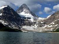
Mount Assiniboine 3,618 m (11,870 ft)
Assiniboine Provincial Park
July 12, 2008
Mount Assiniboine is the highest peak in the Banff National Park in the part of Assiniboine Provincial Park and is called the Matterhorn of the Rockies.
The mountain cannot be reached by car. We chose to approach this mountain by the Bryant Creek Route. We drove from Canmore to the Mount Shark parking lot, where we left our car.
We began our 29 km hike after checking and packing our gear, food, water and all necessary items for staying 3-4 days in the wilderness.
We followed Watridge Lake, crossing the Spray River bridge and turned at a junction to follow Bryant Creek, then turned west to climb the steep trail over Assiniboine Pass while being followed by thousands of mosquitoes. The pass than took us to Lake Magog, where we stayed at the campground.
The next morning we began our walk back since the weather was not stable.
The Mt. Assiniboine area is the only area open to seasonal bear hunting.
At left, Mount Assiniboine with it's reflection in Lake Magog.
At right, Brian and Lubos with a cup of Cafezia coffee. "Coffee in the wilderness, what a glorious taste."
Mount Temple 3543 m (11,624 ft)
Canadian Rocky Mountains - Banff National Park
July 14, 2008 we stand on the summit of
Mount Temple, the second highest peak in the Banff National Park.
We had come from road #1 and camped in the Lake Louise area. In the morning we drove 2 km south on the Lake Louise road and 13 km to the Moraine Lake parking lot.
Brian led us to the SW ridge. The trail head can be found 100 yards along the lake to the right. We followed the trail up to the Larch Valley. The trail winds its way gently to Sentinal pass for an approximately 6 km, then continues up winding its way through the scree to the summit.
Depending on the weather, there can be a couple of slippery sections, but nothing in the way of great difficulty.
We descended the same way. It was a warm sunny day which made our hiking and scrambling very easy.
On the left, the Southwest ridge of Mt. Temple
View of the unmarked but mostly visible trial, photo on the right.
Mount Victoria 3464 m (11,365 ft)
Canadian Rocky Mountains - Banff National Park
July 15, 2008
Mount Victoria
Since I was responsible to wake everyone, we did not make it to the summit of this beautiful mountain. I slept in. We got up at 5:30 am and after the short breakfast we began our hike. It was a very hot day and the avalanches were falling around us left and right. Just small once, though enough to show us the danger. We had to turn back about a few hundred feet above the location of this photo (the photo on the right). We could also hear the river running beneath our feet. Jumping over crevasses, especially on the way back, was quite tricky.
It was so nice to be there. We had a chance to whiteness one large piece of the glacier break off with an amazing sound as it cracked and fell 100 feed below. Even without reaching the summit, it was a gorgeous day.
Mount Athabasca 3,491 m (11,453 ft)
![View from the summit of Mt. Athabasca]() North View from summit of Mt. Athabasca - Mt. Bryce in the view
North View from summit of Mt. Athabasca - Mt. Bryce in the viewColumbia Icefields
July 19, 2008 Brian brought us to
Mount Athabasca The trailhead is just west of Highway 93, 189 kilometers north of Banff . A small road leading to the trailhead is across the highway from the Columbia Icefield Centre. The Snocoach Road leads to a small gravel parking lot on the left.
Brian took us through the North Glacier route. From our experience on Mount Victoria we understood that an early start was mandatory as the snow softens very quickly. We followed directions found in the book of "The 11,000ers of the Canadian Rockies". Here they are: Beyoned the left end of the seracs and just before a steeper slope leading to the Silverhorn Col, head straight up underneath the top of the Silverhorn route (be aware of crevasses), then traverse right on the rising snow ramp. From the top of the ramp, watch for crevasses as you head up more open slopes leading to an often windblown saddle. Follow the usually hard packed and sometimes snow free West Ridge easily to the top of the Silverhorn route and continue on the near level ridge to the summit.
The summit ridge is spectacular.
We descended the AA Col back from the West Ridge.
Mt. Athabasca - Silverhorn route
![Mt. Athabasca]() Brian and Lubos on Silverhorn
Brian and Lubos on SilverhornJuly 20, 2008 Brian
Dunsum and
Lubos approached the Athabasca again this time through the Silverhorn route.
Camping
Camping may be found at the Icefields Campground for about $16.00 per night.
This was my day off at Columbia Icefields.
I went back to my sleeping bag after driving Brian and Lubos to the parking lot. It felt so good. Another nice and warm day. A short walk along the river behind the campground was spectacular. After taking a bath in the river, I lay down on the sun and watched with binoculars my two climbing partners, making their way through the Silverhorn route like two little ants. Surprisingly, in spite to this great distance, I managed to make a short movie of their climb. Later on I went to pick them up again to the parking lot.
Mount Edith Cavell 3,363 m (11,033 ft)
Canadian Rocky Mountains - Jasper National Park
![Mt. Edit Cavell]() Lubos ascending Mt. Edit Cavell
Lubos ascending Mt. Edit Cavell we ascend on July 22, 2008
Directions: Driving approximately 7 km south from Jasper on rte. 93 make a right turn onto 93A at the Edith Cavell turnoff onto Edith Cavell road, drive for about 10 min to the parking lot at the end of the road.
We began to ascend the East ridge at 4:30 am. on a cloudy day. The East ridge is one of the classic alpine climbs in the Rockies, with blocky quartzite rock and superb positions on the upper ridge. The solid holds and reasonable grade make this an excellent moderate route.
Close to the top it started to rain, followed by snow and ice at the very top. Unfortunately we had no view from the summit at all.
Due to icy and slippery conditions, Brian decided to descend the West Ridge, which was a long slog, but in view of the weather, it was safer than trying to go down the East Ridge again.
It was a long day trip.
Photo of Edith Cavell from the trail returning from Southwest ridge.
Day off in Jasper
![Mt. Edith Cavell]() Angel Glacier Lake
Angel Glacier Lake
On this sunny relaxing day we drove back to the parking lot of Edith Cavell and took some day time photos.
Angel Glacier Lake beneath the mountain in the photo on the right.
Diadem Peak and Mount Woolley
July 24-25, 2008 South East Face,
Mount Woolley and
Diadem Peak are twin peaks encircled by receding glaciers just north of the Columbia Icefield and west of the Sunwapta River.
From the Columbia Icefield Visitor Centre, drive 12 km north on the Icefields Parkway and park in a pullout on the east side of the road.
Cross the rigid Suwapta River's braided channels (in July depth of the water was bellow the knee) and walk a short distance downstream to where a major gorge empties into the Woolley Creek. Just left of the gorge, a good trail rises steeply through trees before leveling off and dropping down to the creek. A rough trail follows the left side of the main creek, angling right higher up to wander through the right side of a jumbled boulder field. Beyond the trail climbs left of the small waterfall, then levels out in an open, rubbly basin. Follow a fainter trail left of the upper left branch of Woolley Creek to streamside gravel flats, with a couple of rock-walled tent sites, below a glacier descending from Mt. Woolley (3-4 hours from the car). This information and more can be found in the book of "The 11,000ers of the Canadian Rockies"
The backcountry bivy permits are required for backcountry camping; these may be purchased at the Icefields Center (among other places) for $9.60 cdn. per person.
For all route detail information
The 11,000ers of the Canadian Rockies by Bill Corbett


Comments
Post a Comment