|
|
Custom Object |
|---|---|
|
|
custom |
What's New 2009
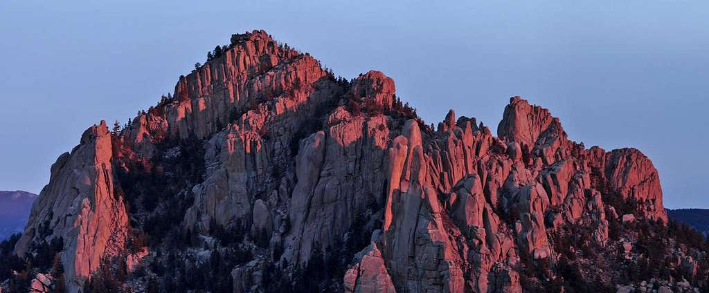
 The Forbidden One, the northwest face of Kiowa Peak-IPW.
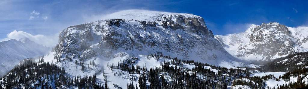
I enjoyed maintaining my 2007 and 2008 pages and look forward to another great year of climbing beautiful Colorado mountains with friends and meeting new climbers that share the same passion. As usual, this page will be evolving throughout the 2009 year. Use the Table of Contents to the right to view what's posted for the season.
My outdoor focus has begun to shift away from aggressively attaining the summits of great mountains, to moving in a direction toward bettering my mountain photography. I’m still interested in summits, and I occasionally will be interested in a peakbagging escapade. Visiting summits is still the best way to see everything.
It’s been an inevitable progression. For 15 years, climbing mountains was my perfect craving, an addiction that on occasion tried its best to come between me and my family (that’s a whole different story.) Up until a few years ago, I climbed hundreds of mountains more or less because I felt I needed to prove something to myself and to others (yes, I admit that). I was always up for a challenge. During my peak bagging tenure, there’s always been one constant, climbing a mountain would never be 100% complete without my camera.
Along that ride by accident I took some cool shots. A pat on the back from the great people at summitpost was always nice and often motivated me. I became fascinated with getting cool shots and studied how to get more cool shots. Last year I started to spend more time researching mountain composition than actual mountain routes. A decade of meticulous topographic map research was paying off; I already had ideas for interesting mountain perspectives. Instead of looking at map contour lines and researching places to go climb a mountain, I was now frequenting photo forums and gear reviews. My existing backcountry knowledge and my passion for capturing beautiful scenery mixed well with one another. And the final straw, the other day, my friend Jim called me a “camera gear junkie.” Things have officially changed for me.
In 2009 I climb mountains because I long to see them in their most intimate and cherished moments. I like remote mountains, forgotten mountains and mountains that reside within highly inspiring terrain. I want to see these mountains from different, unseen perspectives, locations that are known and not known. I’ll need to be in the right place at the right time because capturing that short moment, often only a few seconds, will require precision planning. I realize my desires require hard work but that’s what this is all about, working hard for the shot.
Hallett Peak-Jan 2010

A climbing friend once said “I climb mountains; you take pretty pictures of mountains…we’re different.”
I admit, I like taking pretty pictures.
After a much needed winter storm brought 8-10 inches of fresh powder to the RMNP Divide, I picked up on the short weather window for optimal conditions the day after and selected Hallett Peak as my evening destination. I just love Hallett Peak, it’s really one of the Parks most photogenic mountains, plus the summit has a very nice view, especially in winter. You get a birds eye view of the northern mountains plus all the goodies in the Glacier Gorge area.
A few weeks ago, I hiked up into the Loch area (Glacier Knobs) for an overnighter to scout out lighting conditions on Longs Peak. This is what pretty picture people do when they like to take pretty pictures of mountains. We actually go on scouting trips too. The sun was so far south that without getting up on the Divide, Longs wouldn’t be worth my time at this time of year from this low vantage. I knew I needed to get up on the Divide, thus Hallett Peak.
This was about my 5th time I’ve been in this area of the Park this winter and have come to realize I really enjoy not having to carry snowshoes. I didn't bring snowshoes because I was certain others had paved the way. I can deal with the hordes of winter hikers in the Park; I just love letting them do all the dirty work. In summer, I’m not here.
Where the trail splits going to Odessa Lake or to Flattop, I was scared to death what I saw; a single ski track heading up the Flattop Trail. Holy crap, don’t even think about it Kane, just keep moving forward with your ridiculously heavy pack. Soon afterward, I was praising the God-like skier, and knew I needed to buy him a beer someday. That skimpy ski track was just enough to hold my weight through the trees, all the way to tree line. Yes, I did my fair share of postholing, occasionally punching through to my waist, and once, did the beautiful class 5 Wollowfest action.
I finally reached tree line, pretty confident the winds were not going to kill my day. A person that likes taking pretty pictures doesn’t like the wind either. Low light is when you get the prettiest pictures and adding wind to the mix, makes me think about; why I brought my light weight tripod instead of my beastly “windbreaking” tripod. At any rate, that’s how nice of a day it was…I just knew it wouldn’t be windy in this notoriously windy place!
The weather was truly spectacular and the evening sunset was setting up to be everything I had hoped for. I loved not seeing any clouds off to the west, meaning, I was gonna get some LOW light. LOW light is what makes a …you guessed it, pretty pictures.
I made Flattop, and realized it was just going to be me up here for the rest of the day. The Flattop area is actually an amazing place when its covered in untracked snow, it looks so pristine. Plus you get the cool snow formations from all that wind. I was really beginning to look forward to 5:15.
My beloved ski track finally left Flattop and dropped down Tyndell Glacier. Everything around me was officially mine for the rest of the day. I continued on to Hallett Peak, dealing with some annoying cramping in my lower extremities.
Halletts summit has a nice wind shelter up there and after I dug it out I set up shop for the next 3 hours. I learned something new, waiting for an hour or two at 12,700-ft in winter, regardless of the “better” conditions, you still get cold! I moved my glove warmers to my feet to join my feet warmers, a total of two warmers per foot. Still got cold feet.
Now I wait for a 5:15 sunset. And wait...and wait....
I tried doing jumping jacks to warm my feet.
Things begin to get better….and better….
I tried continuously kicking snow off the toes of my feet...like that's gonna work. Must be bored waiting....
A friend once said to me while approaching Capitol Peak via Pierre Lakes at 5:00 am “Kane, it’s on!”
The show had begun. It felt incredible being the only one up here.
There’s nothing better then watching Gods handiwork light up so brilliantly. When you see it enough, you realize there are different stages to this sunset thing. I try not to get too caught up in the “before sunset” thing but rather get super hyped for the after sunset thing; alpen glow, there’s nothing quite like it! It's addictive too. Sometimes I just don't feel like hiking in the day, it's just not the same as dusk and dawn.
I'm even beginning to like this nightime hikeout as well, especially under a full moon. Gonna have to start paying close attention to the Full Moon symbols on the calender.


4-20-2009-The Loch, RMNP
After a massive upslope storm dropped almost 3 feet of snow in Rocky Mountain National Park, I had to get in there to see what that looked like. My original plan was to hike up Joe Mills Mountain and shoot the sunrise from the summit. Joe Mills has what I would call an "in your face face" view of Notchtop Mountain, and with the right kind of alpen glow, I'm was looking at a potentially great photo opportunity.
Met a man in Estes Park the night before the hike that informed me that Joe Mills may be too ambitious considering the 3 feet of new, wet snow. He spoke about 2 feet of unconsolodated spring snow, topped off with a nice thin crusty top layer. A perfect postholing affair would be in order. He also talked avy danger, noting that N slopes of Flattop can slide in this kind of deep dump. Considering only one day went by since the storm, I decided to pick something safer, like another trip up the Glacier Knobs, this time for sunrise of the Loch.
The following is a shorthand journal of my day.
Was hiking by the Glacier Basin Trail by 4:00 am, new fast it was going to be windy. Didn't like the idea of wind and the exposed Knob area. I could see my tripod blowing away.
There was a trench all the way to the turn off area, no need for the slowshoes. I was making great time. Only problem, couldn't find the turnoff area. Got lost in the trees basically. Too many little trenches everywhere. Couldn't leave the comfort of trench, could tell any movement without trench would be heinous. GPS was going bonkers in the trees. Became super frustrated after wasting about 20-25 minutes looking for the Loch Trail. I new I wasn't going to get there in time. Decided to hike to Mills Lake for sunrise. Underwhelming sunrise due to boring composition and flying snow.
The wind was blasting me, to the point I wanted to go home. Since I could finally see around and look for landmarks, I finally spotted the Loch drainage. Took the trench down to a flat spot in the trees and realized why I couldn't find the Loch Trail. Cuz, there wasn't one...yet. 7:00 am, new I had all day, donned slowshoes and began the suffering process. I liked the idea of being the first one to the Loch after the big storm. Yes, it was slow going but very much worth it. The snow got a lot better the higher I got. Things looked a lot different from a week ago, when you and I were up there. Went to the Loch first, then hiked up to the knob. The knob was covered in 2-3 feet of snow. Lot's of blowing snow up high on the peaks. It wasn't bad down on the knob because it wasn't a cold wind. I did lose my sunglasses to one massive gust where I held my tripod with my big lens and forfeited the glasses.
3-28-09-Dream Lake-RMNP
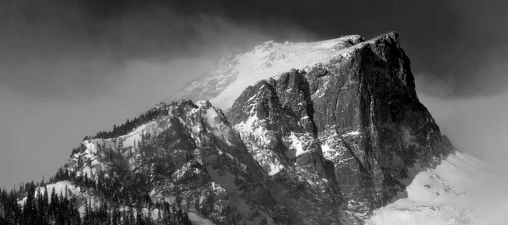
My first dive into the black and white world of Rocky Mountain National Park. Lots of potential here. High contrast, massive granite walls with blowing snow make for good B&W composition.
3-8-2009-The Catamount-LCW
Steve Knapp e-mailed me an invitation for a Lost Creek Wilderness hike on Sunday. I thought another day on the Catamount sounded good and Steve liked the idea of getting two ranked 11ers, Lake Park Peak and South Tarryall. Spruce Grove TH was the common ground so we decided to bring radios and together hike to Hankins Pass, then part ways and climb our objective(s).We arrived at the TH and to our surprise a group of well prepared hikers were gathering gear for what appeared to be a long day. These had to be 14erworld members! Turned out to be Dave, Tyson, Amy, Ricky and Kurt, all looking forward to climbing the Catamount. The Catamount welcomes maybe 3 visits a year, so what are the chances of meeting others with the same objective?
I’ve hiked with Steve before so I was well aware that I was in for a nice cardio work –out. Not only does Steve have a long stride, he also hikes fast. I was a little concerned with my conditioning; but it was nice knowing if Steve morphed into a mountain goat for the hike to Hankins Pass, soon after, I could crawl solo to the Catamount if I pleased.
The morning was clear and crisp, about 17 degrees with a slight breeze. The west side of the Tarryall Range was mostly void of snow so we elected not to bring snowshoes. I’ve been duped before; leaving snowshoes in the car, in dry looking conditions, to desperately needing them when arriving in the high flat meadow areas that encompass these peaks. Any second guessing was laid to rest with knowledge of my west face route up the Catamount has tremendous southern exposure. From Twin Eagles, the entire route is visible.
There’s a complicated ramp system that graces the west face of the Catamount. I discovered this line about 7 years ago after climbing the cold, steep north face. From the summit I spied a reasonable line descending the Catamount’s west face. A few years later I attempted that line and made the summit. I had a vague memory that something to do with losing my mind trying to locate that route within the maze of copycat boulder ridden walls of granite; a sneak preview of things to come.
I actually felt pretty darn good all the way to Hankins Pass. The familiar hike was uneventful except for an occasional short conversation with Steve. The remaining snow residing on north facing aspects of the trail was well traveled and made for quick travel. Steve took off for S Tarryall and I layered up to prepare for the cold wind which seemed to be getting stronger the higher we got. At this point I lost my watch. Thankfully I had my GPS.
I made Lake Park in good time. As expected, the upper park area was drifted over however I could see the actual meadow area below had enough bare tundra to look encouraging. I post holed for about 10 minutes, and then began connecting dry ground with more dry ground until I reached the heinous but beautiful south slopes of the Catamount. This boulder strew slope is riddled with rock spires and domes and for good measure infested with stunted aspen trees and downfall.
I enjoyed my disgusting bushwack until finally reaching a dry, sandy plateau with a good view of the rest of my route. I made way to what appeared to be the west face of the Catamount and quickly found a line that seemed familiar. I topped out about 15 feet from the summit. This line seemed too technical. I downclimbed and surveyed the complicated terrain. I tried another line just a few feet from my first attempt. I topped out about 10-ft from the summit area. I became frustrated and confused, again. I had climbed this damn peak before and I was completely baffled as to where I was. I downclimbed, traversed about 60 feet, attempted another line and got into some nasty, exposed crap that made me reconsider my day. Steve radioed and said he was already to Lake Park from S Tarryall and was headed for Lake Park Peak.
Later, I decided that I would completely circle this peak until I found my route. I found a tiny notch in a wall, climbed through and found myself within another hanging garden surrounded by more walls of granite. This secret place seemed to feel better. I hiked up another snowless slope to another steep wall and Bingo! There it was- my route. I felt like an idiot, all that earlier climbing was instead on one of the many snake-like ridges that sweep away from the actual Catamount. Live and learn, again.
I would consider this route exposed class 3+. It’s basically class 3 with interesting route finding until you reach a small platform just before the summit block. A tough 6-ft class 4 mantle move is required to make the summit.
On the summit, I signed the well preserved summit register. Only one person signed it last year and that would be Jeff Kunkle. I searched for the 14erworld group but couldn’t locate them. It was odd, it took me about an hour to finally summit and I was actually prepared to spook em by popping up the opposite side of the summit block. I had a look down the steep north facing gully. I could see plenty of snow and ice. It looked cold and spooky, but I knew if anybody could climb up through that stuff it would be Kurt. I also considered I was overestimating the difficulty and wouldn’t be surprised if they all made it up.
I radioed Steve while he was on the summit of Lake Park Peak and told him to stay still while I zoomed in and took a photo of him 2 miles away from the Catamount. Soon after I downclimbed into the hanging garden worked my way around the maze and headed on back to meet Steve at the pass in Lake Park. On my way out I never found the 14world group.
The hike out was fast, and the welcome comfort of warmer weather was perfect. Another great day in the Lost Creek Wilderness.
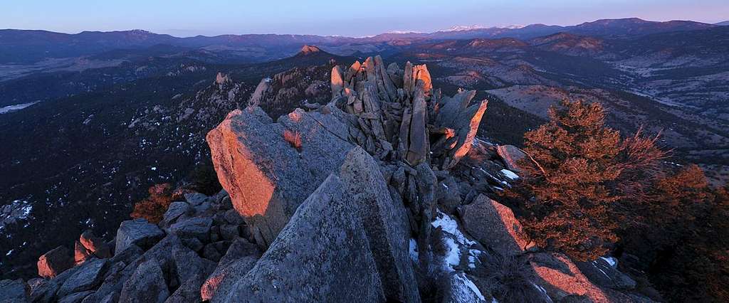
Buffalo Creek-Cathedral Spires
Yep. I'm not sure any of you have had this kind of perspective of Cathedral Spires. It seems relevant and worth sharing considering this perspective shows how beautiful this peak really is.Had the flu last week. Needed something short and sweet.
Woke up at 2:45 Sat morning, picked up my Dads bike, drove to the Top of the World Campgound Road, rode the bike 4 miles to Chair Rocks, ditched the bike and headlamped to a spot I've been researching for months...and waited for about 2 minutes of sunrise.
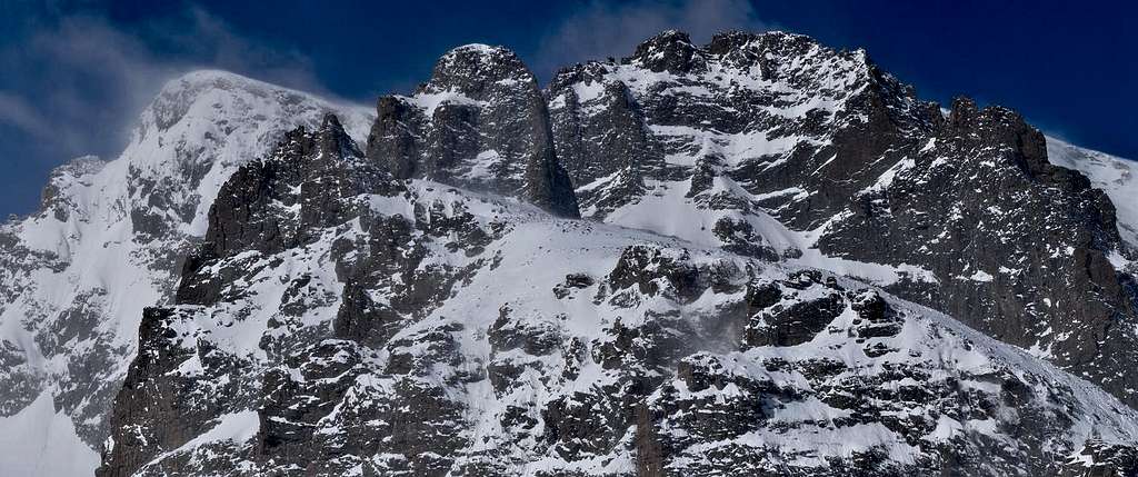
2-22-09-Cathedral Spires
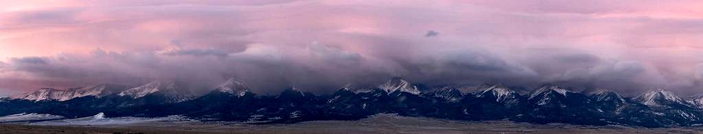
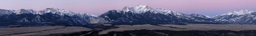
Collegiate Sunrise
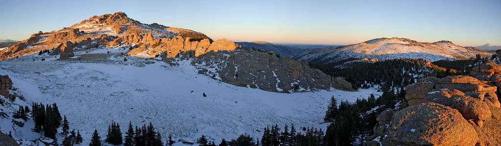
1-16-2009 Bison Peak
1-14-2009-Raleigh Peak
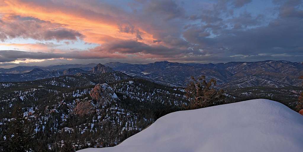
Raleigh Peak is located in the Buffalo Burn area about an hour from Denver. The main objective was to get out. I hadn't been out in weeks due to the holidays. My next objective was to get a sunset photo overlooking the Cathedral Spires area.
It was a tougher climb than I expected due to the massive snowcovered boulders and cactus-like bushes that frequent the space between the boulders. Sounds fun doesn't it? The summit area has two big trees blocking the view that I wanted to the northwest so I had to do a cold, snowy downclimb on the north face to a platform-like boulder; wet and frustrated I still managed a few good shots.
On the drive out, I saw my first Mountain Lion. Damn thing was the size of a Rottweiler!
Storm