La montagna chiama i suoi figli, ed essi rispondono fedelmente al suo appello…
Osvaldo Cardellina, Diario alpinistico, 1964-65
Page texts: @ OsvaldoCardellina"Osva", passed away on May 2, 2022. Page owners: Christian Cardellina e Osvaldo Cardellina. Any updates from September 12, 2022: Antonio Giani, page administrator, friend and climbing companion.
Testi della pagina: @ OsvaldoCardellina "Osva", scomparso il 2 maggio 2022. Proprietari pagina:Christian Cardellina e Osvaldo Cardellina. Eventuali aggiornamenti dal 12 settembre 2022: Antonio Giani, amministratore della pagina, amico e compagno di salite.
OVERVIEW
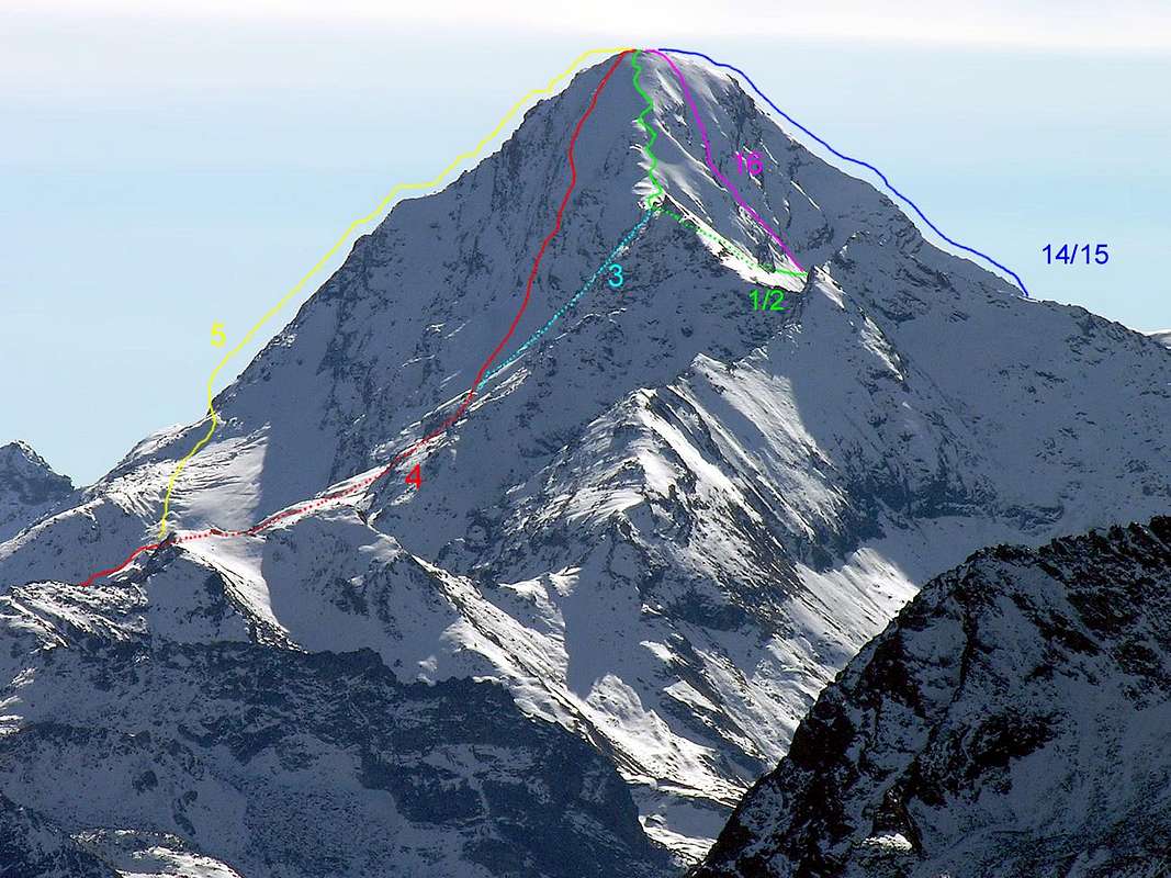
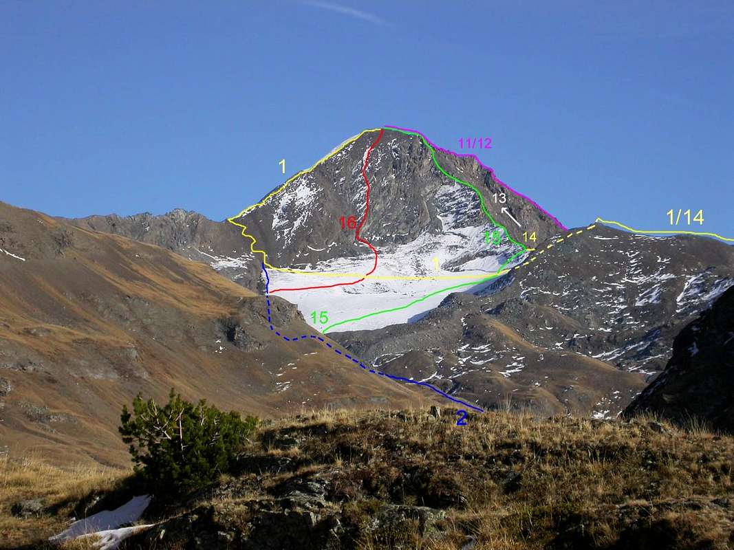
The Tersiva Peak is a regular pyramid with five crest lines and five rock faces, it is situated between the Villages of Cogne and Fénis; it is the second highest peak among the Groups of M. Emilius, M. Glacier/M. Delà, M. Avic/M. Rouvic and Rosa dei Banchi. Its crest lines in the NW and in the SW are set on the watershed of the above – mentioned villages, while other two crest lines form a "comma" up and down on the transversal axis in the E/W. The E Crest line depletes itself briefly on the "Alta Comba Tersiva"; the W Crest line slopes down in the SW for a short stretch forming the Serra Madù or Madou (it runs parallel to another crest line which is an end in itself and goes down in the direction of the Invergneux and Pianas Alps) then it moves west towards the Passo Invergneux or that of des Hevergnes and it rises in order to form the Testa di Vallonet, the two Penne Blanche Mountains (in Celtic Pen= Summit), the Pointe Coupé, the Testa of Money and finally it finishes together with the "Monte Creya" and the Montsalet above the Villages of Gimillan also Gemillan, Cogne and Lillaz. It has two glaciers called Tessonet or Doreire in the W and Glacier of the Punta Tersiva in the NE. The peak itself is quite bright thanks to the clear sky, from where the place name of Tersiva. Its brightness seems due to the quality of the rock (a particular coloration and a peculiar thermic reaction) when it comes into contact with the air; during limpid days from its peak you can see the Ligure Sea. However this summit doesn't offer so many climbing satisfactions, since it is almost everywhere in degradation. We are going to describe briefly the history of the routes clockwise starting from the NW crest line also called normal, which goes down the "Tersiva's" Pass.
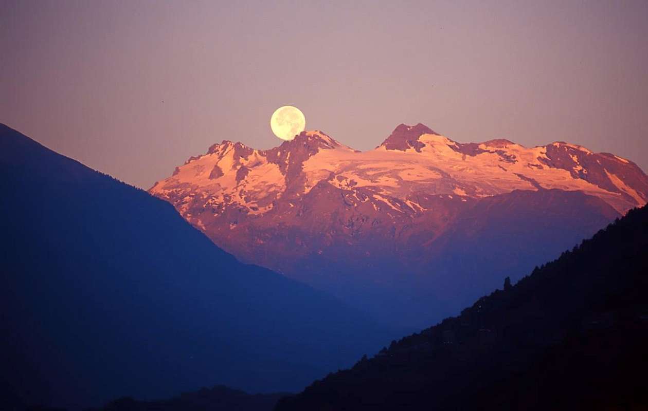
Testa of Rutor Sun 1998
Tersiva Sun
La Tersiva è una piramide regolare con 5 creste e 5 pareti, posizionata tra i Comuni di Cogne e Fénis; è la seconda vetta per altitudine tra i Gruppi del M. Emilius, M. Glacier/M. Delà, M. Avic/M. Rouvic e Rosa dei Banchi. Le sue creste Nordovest e SW sono poste sullo spartiacque dei due comuni succitati, mentre altre due, sull'asse trasversale E/W, formano una "virgola" in su e una in giù. La Cresta E si esaurisce brevemente sull'Alta Comba Tersiva; la Cresta W declina a Sudovest per breve tratto formando la Serra Madú o Madou (parallela ad un'altra cresta, fine a se stessa, che scende in direzione delle Alpi Invergneux e Pianas), per poi indirizzarsi nuovamente ad W verso il Passo di Invergneux o des Hevergnes rialzandosi a formare la Testa di Vallonet, i due Mont Penne Blanche (in Celtico Pen= Sommità), la Pointe Coupé, la Testa di Money per poi terminare con il Monte Creya ed il Montsalet sopra gli abitati di Gimillan o Gemillan, Cogne e Lillaz. Possiede due ghiacciai: del Tessonet o Doreire ad Ovest e Ghiacciaio della Punta Tersiva a NE.Nearly 77 Authors in Seven Valleys (By Camillo) TERSIVA & SERRA MADU' from Southwest 1974 Bella vetta, un tempo di gran moda, è conosciuta per il suo splendido panorama sull'arco alpino occidentale e sull'intero Gruppo del Gran Paradiso. Lo stesso, alquanto limpido per il cielo terso, donde il toponimo Tersiva, pare sia dovuto alla qualità della roccia (colorazione particolare e relativa reazione termica) che al contatto dell'aria lo determina. In giornate particolarmente limpide dalla vetta si può scorgere a occhio nudo insin al Mar Ligure. La stessa però non offre altrettante soddisfazioni nell'arrampicata, essendo quasi ovunque in disfacimento. Descriveremo in sintesi la storia delle vie in senso orario a partire dalla cresta Nordovest, o via normale, che discende sul Colletto della Tersiva.
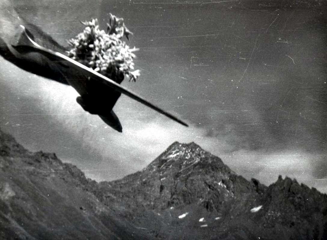
Two authentic and only documents, found again by the author the eight of September 1974 among the snowstorm that dispersed the sheets of the Book of Peak of the Point Tersiva, that pertains to the first true ascension of the Wall North-northeast in 1910 and to 1920 olds ascension through the Normal Route with departure from Cogne Village.
Due documenti autentici ed unici, rinvenuti dall'autore l'otto di Settembre 1974 tra la tormenta che disperdeva i fogli del Libro di Vetta della Punta Tersiva, concernenti la prima vera ascensione della Parete Nord-nordest nel 1910 ed una vecchia ascensione del 1920 lungo la Via Normale con partenza dal Borgo di Cogne.
BRIEFLY OF THE ROUTES CLOCKWISE STARTING FROM THE NW CREST LINE (NORMAL ROUTE) and Detailed Bibliography
FROM COGNE ROUTES
01) - N-NW Arête Normal Route from Lillaz: (from Lillaz (Cogne's Village) - Urtier Valley Invergneux's Pass 2.902/5 meters: by routes 10A, 10, High Route n° 2 and 10D TVC (= TOUR of the Cogne's Valley - Great Paradis) Goilles's Dessus Little Village 1.869m - little bridge 105m in Taverona/of Farcoz/Seutse Torrents - little bridge 160m in Gueula's Torrent Crest Alp (ruines) and "Alpine Toups Chapel" (fountain) - little bridge 2.190/5m to "Cote Piemont" (=rocky coastline. In ancient times transit/passage and land iron transport, "magnetite" (loadstone), renowned in the world, from Cogne, Mount Creya Area (Colonna's/Costa's del Pino and Larsinaz's Seams/Veins), to Piemont Region by of the Arietta, Miserino, Scaletta, Rancio's Bocchetta and Acque's Rosse or Eaux's Rousses also Reds Waters's Pass" in Urtier's Torrent - Tsavanis's Waterfall and Alp - little brige 2.360m in intersection of the, from North or left, Urtier's/Ponton's and Peradzà's Torrents - Pianas's/Invergneux's Alps - Invergneux's Alps and Pass (2.902/5m) - Serra Madù or Madou (Quota 3.220m) - sides South and East of the Tessonet or Doreire Glacier (in descent from Summit Madou Serra's to glacier) in crossing Southwest/Northeast to pass's base quota 3.200/10 meters and West Slope Tersiva's Pass 3.312m): Pietro Balbassarre Chamonin, Cogne's Curate, and one unknown student; Aug 23th, 1842; First in winter Mario Aldrovandi and wife with Giuseppe Vassoney, mountain's guide of Champorcher; Jan th?, 1930. First skiing Aldo Bonacossa & Company; ? th? 1921; difference in level 1.900m; 300 in terminal part; (35°/30°/42°); F+/PD/F+.
"L'Alpinista"1875/77 - Magazine of the C.A.I., page 106, Edit, by C.A.I."Guide de la Vallée d'Aoste", by Charles Bich and Aimé Gorret. Edit Casanova in Turin, 1876. " Bollettino del C.A.I. 1903 -Bulletin of the C.A.I., page 15. Edit. by C.A.I. in Turin 1903/69. "Guida della Valle di Cogne" and " Guida della Valle di Champorcher ", by Mario Aldrovandi. Edit. Lattes in Turin, 1930/32. "GUIDA della REGIONE AUTONOMA della VALLE D'AOSTA", by Mario Aldrovandi, page 150, 195 and 289. Edit. S.P.E. of Carlo Fanton in Turin, Dec 31th, 1964. "Gran Paradiso ITINERARI SCELTI ALPINISTICI ED ESCURSIONISTICI DEL VERSANTE VALDOSTANO", by Pierandrea Mantovani and Renato Misischi, pages 24/5 ( Tersiva ... 1 Per il versante Ovest e la cresta Nord-Nord-Ovest). B&W Map 2 cm: 1.000m in page 22. Edit. Rassegna Grafica RASSEGNA ALPINA in Milan, Jun, 1974. "80 itinerari di escursionismo alpinismo sci alpinismo in valle d'aosta", by Osvaldo Cardellina, pages 86/7. Edit. Musumeci in Aosta, Jun 1977.Reprint Jul 1981; third Edit. Jul 1984. In French February, 1978 and March, 1980. "IL PARCO NAZIONALE DEL GRAN PARADISO VOL. 2° Valli di Champorcher - Clavalité - Saint Marcel - Laures - Cogne - Valsavarenche - Conca di Pila", by Giulio Berutto, page 166. Edit Istituto Geografico Centrale Torino in Turin, Nov 21th, 1981; reprint Juny 2000. "Gran Paradiso itinerari alpinistici e sci-alpinistici", by Franco brevini, pages 52/3 ("1a Versante sud e cresta nord-ovest Via normale dall'Urtier"). Edit. Musumeci in Aosta, Jun, 1982. "VALLE D'AOSTA oltre il sentiero 60 itinerari di escursionismo impegnativo e di alpinismo facile dal Mont Avic al Monte Bianco", by Pietro - Matteo Giglio, pages 42/4. Edit. CDA Centro Documentazione Alpina Torino in Turin, Mar 1993. "a piedi in VALLE D'AOSTA VOL. II 116 passeggiate, escursioni e trekking alla scoperta della natura", by Stefano Ardito, pages 225/6 (route 728: "Nel Vallone del Grauson" and 227/8 (route 729: "Punta Tersiva (3.515m)", Edit. GUIDE ITER in Subiaco (Rome), Jul, 2004. "Gran Paradiso Gebietsfuhrer fur Wanderer, Bergsteiger und Kletterer", by Gerd Klotz, page 224 ( "615 Punta Tersiva, 3.515m ... 616 Nordnordwestgrat"). B&W photograph in page 225 (Punta Tersiva von Norden R 616 Nordnordwestgrat). Edit. BERGVERLAG ROTHER GMBH. MUNCHEN, Bad Orb, im Fruhjahr 2005. Guida dei Monti d'Italia "Emilius Rosa dei Banchi Parco del M. Avic", by Giulio Berutto and Lino Fornelli, pages 41 and 156/7. Edit. C.A.I./T.C.I. in Milan, Mar, 2005. University's of Turin Thesis "Variazioni Glaciali nel Gruppo del Monte Emilius" (e della Tersiva) by Alessandro Giusto Cardellina; (unpublished), 2009. "Diari Alpinisici Ascensioni 1964/2013", di Osvaldo Cardellina con Indice Generale accompagnato da Schedario Relazioni 1964/2013 (inedito) - "Mountain' Diarys Ascents 1964/2013", by Osvaldo Cardellina with General Index and Report's of Ascents 1964/2013 (unpublished).
01bis) - OLD VARIANT HISTORIOGRAPHIC deserted for dangerouness of the glacier; noumerous crevices extant. As a historiographic title integrated; (from Invergneux's Pass: or Hevergnes's also Invergnaou's (= of Winter Pastures's. In ancients times for the whole winter populated; altitude 2.524m!). Invergneux Pass (2.902/5m) - West Slope Serra Madou or Madù - ancient passage 3.178m at NW base Serra's to Tessonet'/Doreire's Glacier,S-SW sector - crossing SW/NE to base of the Tersiva's Pass 3.312m). First in route? In the mists of time by inhabitants of the valleys in transitfrom Champorcher's Valley - Dondena Alps (by Pontonnet's Pass and West three littles Lakes also called by Fenetre Pass - source 2.742m - little lake 2.756m - source 2.673m - Lake and Alp of the Ponton's Tower - Baita Orlando to Invergneux's Pass). Also called from Urtier's Valley by Crest(Ancient Alp and Old Chapel, at present to war memorial of the Alpine Troups Corps dedicated) , Tvavanis's/Pianas's/ Invergneux's Alps and Pass to of the Grauson/Doreire and Grauson's/Lussert's Valleys, round trip.
"GUIDA della REGIONE AUTONOMA della VALLE D'AOSTA", by Mario Aldrovandi, page 289. Edit. S.P.E. of Carlo Fanton in Turin, Dec 31th, 1964. Priv. inf. by Vincenzo Perruchon in Cogne, Hotel "Roccia Viva", August 1990. Thesis "Variazioni Glaciali nel Gruppo del Monte Emilius" (e della Tersiva), by Alessandro Giusto Cardellina. Studys's University of Turin, Faculty Mathematicals, Phisics and Naturals Sciences/Course Degree. Turin Apr 24th, 2009. Priv. inf. by Renzo Jeantet in Lillaz (Cogne), Jun 02th, 2009. Priv. inf. by Ezio Savin in Cogne Jun 02th, November 15th, 2009 and Mar 22th, 2010.
02) - N-NW Arête Normal Route from Dzimillan and Grauson/Doreire Valley: (from of the little bridge 1.840m upon Gimillan's Torrent (in NE of the Gimillan Village) or Gemillan (Dzeme(i)llan in "patois"(= language)of Aosta Valley's) by route 8 and TVCto Grauson's/Lussert's/Doreire's-Tessonet's Valleys - Reventis Alp (ruins) - Tarabouc Alp 1.831m ( Ancient Chapel) - Ecloseur's Little Chapel - Tzecheu Lower Alp - Ecloseurs's little bridge upon Lussert's/Corona's/Doreire's/Money's Stream and Alps - Pila's Waterfalls Alp - Grauson or Groson Vieux Alp(in tableland "Pré-Vaudan Source" near Ervillières and variaous Torrents) - Grauson/Doreire Valley: Bridge 2.298m on Money's/Tzte's/Grauson's/Ervillières's/Doreire's and Corona's Torrents - Pralognan Alp - Ervillères Alp - section of left in edge (North) Tessonet's/Doreire's Glacier'sto pass's base 3.200/10 meters and West Slope Tersiva's Pass 3.312m): D. W. Freshfield and F. Dévouassoud; Aug th?, 1877; First in winter (absolute of the mountain) Giuseppe Corona & Company Feb 02th, 1875; difference in level 1.800m from Gimillan Village; 300m (terminal part); (35°30°/42°); F/F+.
"DAL MONVISO AL SEMPIONE 105 gite con gli sci in Val d'Aosta, Susa, Lanzo, Ossola e altre undici valli delle Alpi Occidentali", by Roberto Aruga and Cesare Poma, pages 106/7. B&W phopo with track in page 107.B&W Map" 1,7 cm:2 Km in page 106. Edit. CDA Centro Documentazione Alpina Torino in Leynì, May, 1979. "3 IL PARCO NAZIONALE DEL GRAN PARADISO Vol. 2° Valli di Champorcher - Clavalité - Saint Marcel - Laures - Cogne - Valsavarenche - Conca di Pila", by Giulio Berutto, pages 158/160 and 287 (ski-mountaineering route). Edit. Istituto Geografico Centrale Torino in Turin, November 21th, 1981; reprint Jun 2000. "Gran Paradiso itinerari alpinistici e sci-alpinisti", by Franco Brevini, page54 ("1b Versante ovest e cresta nord-ovest Via normale dal Grauson") and in Second Part ski-mountaineering routes in pages 192/3 ("Punta Tersiva 3.515m"). Edit. Musumeci in Aosta, Jun, 1982."Gran Paradiso itinerari escursionistici 2, by Franco Brevini, pages 116/7 ("55 Traversata Gimillan (1.787 m) Vallone del Grauson Passo di Invergneux 2.905m Vallone dell'Urtier Lillaz 1.617m"). Edit. Musumeci in Aosta, July, 1982."a piedi in VALLE D'AOSTA VOL. II 116 passeggiate, escursioni e trekking alla scoperta della natura", by Stefano Ardito, pages 221/3 (route 724 "Nel basso Vallone dell'Urtier" and "Nel Vallone dell'Urtier") and pages 227/8 (route 730 "Punta Tersiva (3.515m)". B&W Map 1 Km: 1,6 cm in page 184; with tracks in green of the routes. Edit GUIDE ITER in Subiaco (Rome), Jun 2004. Thesis "Variazioni Glaciali nel Gruppo del Monte Emilius" (e della Tersiva), by Alessandro Giusto Cardellina. Studys's University of Turin, Apr 24th, 2009. (Besides see above 01 of the: 1875/77, 1876, 1930/32, 1964, 1990, 1993 and 2005 (2 edit.)) and 01bis.
FROM FENIS VALLEY ROUTES
03) - N-NW Arête Fénis's Tersiva Pass: (from Fénis little Town, Barche Village - Arbussayes - La Cerise - Le Plan-Mayen - Le Leffrey - La Servettaz - Lovignana (1.169m) (warning notice for motor vehicles; by route's signals n° 2A) - Les Fontaines - Marqueron - Robbio or Robioz Village/Alp (1.564m) (fountain near Clavalité's Torrent) and Clavalité's Tableland numerous littles villages and alps: Le Chapieux, Chez-Ramin, Bayette Dèsot (=Lower) Chez-Boz or Chez Boche, Milana (Notre Dame de Neige old Chapel), Rovarey, Les Maisonnasses (1.534m) - Maison-Blanche, Chardonney, Bioley Dèsot and Damon (= Upstairs or Higher), between the Bioley's and Bayette's Forests,(various fountains) . From Bioley's Damon/Crin's crossroads 1.551m by signals n° 5to Val Fénis, by two routes: A) - in left (E), by a dirt road (Revers's Wood, crossroads Crin's 1.587 meters, Revers, Coujeic, Beneyte, crossroads 1.753 meters, near Clavalité's Torrent. B) - in right (W), by path along Clavalité's Torrent to La Coutà/Celey Damon/crossroads 1.753 meters. From junction 1.753m to Bayet, Meney Dèsot, di Meitin and Damon (= Lower,Half/Middle and Higher), to Etsely's Lower Alp crossroads 2.027m. From crossroads by signal n° 6to Grand Alp 2.120m (= Great Pasture). From Grand Alp in NW, by route n° 7, 102 to Lavodilec Lake until quota 2.127m, then in SW without tracks in "High Little Comba" (=little valley) Tersiva's - right side (North) of the Tersiva Old Glacier (by that time pratically extinct and in permafrost effect-phase)to pass's base quota 3.050/100 meters and East Slope Tersiva's Pass): First? Giovanni Bobba and G. Pession; Sep 08th, 1901, in ascent; A. Lucat, A. Decaroli and J. J. Maquignaz; Aug. 02th, 1875, in descent. First skiing Toni Ortelli, Venturello, Zangelmi & company, in descent; Apr 25th, 1942; diff. in level 2.950m from Barche; 400/50m (term. part); PD+.
"GUIDA della REGIONE AUTONOMA della VALLE D'AOSTA", by Mario Aldrovandi, page 195. Edit. S.P.E. of Carlo Fanton in Turin, Dec 31th, 1964. "IL PARCO NAZIONALE DEL GRAN PARADISO Vol. 2° Valli di Champorcher - Clavalité - Saint Marcel - Laures - Cogne - Valsavarenche - Conca di Pila", by Giulio Berutto, pages 83/6 ("A 31 TRAVERSATA DAL RIFUGIO MISERIN A FENIS PER IL COL FENIS 2.831 m" ; "B 1 PIANO DI CLAVALITE' 1.514 m" ; page 94 ( "B 7 TRAVERSATA DAL PIANO DI CLAVALITE' AL RIFUGIO MISERIN PER IL COL FENIS 2.831m"). Page 94 ("C 2 TRAVERSATA DA LES DRUGES (S. MARCEL) AL PIANO DI CLAVALITE'"). Edit. Istituto Geografico Centrale Torino in Turin, Nov 1981; reprint Jun, 2000. "a piedi in VALLE D'AOSTA VOL. II 116 passeggiate, escursioni e trekking alla scoperta della natura", by Stefano Ardito, pages 185/7 (route 612 "Da Lovignana al Piano di Clavalité" and route 613 "L'anello dei valloni di Savoney e di Fénis". B&W Map 1 Km:1,6 cm with tracks, in green, in existence, page 184. Edit. GUIDE ITER in Subiaco (Rome), Jun, 2004. Thesis "Variazioni Glaciali nel Gruppo del Monte Emilius" (e della Tersiva), by Alessandro Giusto Cardellina. Studys's University of Turin 2009. Priv. inf., remarks, reports and connections , by Battista Pieiller Nov/Dec, 2009 and Jan 18th, 2010. Priv. inf., remarks and reports, by Maurice Gaillard Nov/Dec 2009.
04) – N-NE Wall Central and Superdirect Route: (from Fénis, Barche Village - Clavalité' Tableland - Robbio (fountain) - Val Fénis - "High Little Comba" Tersiva's - middle area of the Tersiva's Glacier (See route 03) to wall's base quota 2.860/5 meters): Gigi Panei and Lucien Salval; Sep 05th, 1937; d. in lev. 2.950m from Barche; 650m (term. part); (40°/45°/50°); AD-/AD+/AD. (See route 03).
Sole Document, in the Summit retrouved by Osvaldo Cardellina, in Sep 08th, 1974. Guida dei Monti d'Italia "Emilius Rosa dei Banchi Parco del M. Avic", by Giulio Berutto and Lino Fornelli, page 158. Erroneus Micky Salval (son) but Lucien Salval. Edit. C.A.I./T.C.I. in Milan, Mar, 2005. Thesis " Variazioni Glaciali nel Gruppo del Monte Emilius" (e della Tersiva), by Alessandro Giusto Cardellina. Studys's University, Naturals Sciences, of Turin 2009. (Besides see route 03).
04) bis – N-NE Wall Left Route, new route, and E-NE Arête: (from Fénis, Barche Village - Clavalité Tableland - Robbio (fountain) - Val Fénis - "High Little Comba" Tersiva's - middle sector of the Tersiva's Glaciersto face's base quota 2.860/5 meters): Maurizio Gaillard, Valpelline's mountain's guide of Fénis and Sergio Pession; Dec 26/27/th, 1980; d. in lev. 2.950m from Barche; 650m (term. part) (470m+180m in N-NE Ar.); (40°/43°/48°); AD/AD+/AD-.(See route 03).
"Montagnes Valdotaines" - Magazine Section's C.A.I. of the Aosta, Year VII n° 1 (17), page 7, May, 1981. Thesis "Variazioni Glaciali nel Gruppo del Monte Emilius" (e della Tersiva), by Alessandro Giusto Cardellina. Faculty of the Naturals Sciences Turin's, Apr 24th, 2009. Privates Informations, remarks, reports and connections by Maurice Gaillard Nov/Dec, 2009. Priv. inf., reports and remarks by Sergio Pession Dec 2009 and Jan, 2010. (Besides see route 03).
04)ter – N-NE Wall Right Route, new route:(from Barche Village - Clavalité Tableland - Robbio - Val Fénis - "High Little Comba" Tersiva's - middle zone of the Tersiva's Glacier to wall's base quota 2.860/5 meters): Battista Pieiller, of Fénis and Andrea Piccot of Fénis; Jul, th?, 1979; First in winter Maurizio Gaillard, Valpelline's mountain's guide and Sergio Pession, of Quart; Jan 04th, 1984; d. in lev. 2.950m from Barche>; 650m (term. part); (40°/45°/50°); AD-/AD+/AD.(See route 03).
Thesis "Variazioni Glaciali nel Gruppo del Monte Emilius" (e della Tersiva), by Alessandro Giusto Cardellina. Faculty of the Naturals Sciences Turin's Course-Degree; Turin Apr 24th, 2009. Priv. inf., remarks and reports by Maurice Gaillard Nov/Dec 2009 and Jan 2010. Priv. inf. by Sergio Pession December, 2009 and January, 2010. Priv. inf., reports, remarks and connections, by Battista Pieiller Nov/Dec 2009 and Jan 18th, 2010. (Besides see route 03).
04 quater - N-NE Wall Direct to Summit:(from Barche - Clavalité Tableland - Robbio - Val Fénis - "High Little Comba" Tersiva's - middle area of the Tersiva's Glacier to quota 2.860/5 meters at of the face base): Battista Pieiller, solo; Jul th?. 1981?; 1° replay Battista Pieiller, of Fénis, and Sergio Pession, of Quart; Jul th?, 1982 or '83?); d. in lev. 2.950m from Barche; 650m (term. part); (40°/47°/52°); AD-/AD/AD+. (See route 03).
Thesis "Variazioni Galaciali nel Gruppo del Monte Emilius" (e della Tersiva), by Alessandro Giusto Cardellina. Faculty of the Naturals Sciences Turin's, Apr 24th, 2009. Priv. inf., remarks,reports and connections by Battista Pieiller Nov./Dec. 2009 and January 18th, 2010. Priv. inf., remarks and reports by Sergio Pession Dec 2009 and Jan 2010. (Besides see route 03).
05) – E-NE Arête "Fénis's Crest": (from Barche - Clavalité - Val Fénis - "Tall Little Comba" Tersiva's - North-northeast side of the Point Tersiva's Glacierto ridge's base quota 2.220/2.500/2.700/3.000 meters about by various of theOpening VARIANTS): Carlo Giachino, O. May, Giuseppe Pollano, Enrico Bravo, Bartolomeo Garelli, A. Verani-Masin, Angelo Perotti,of Turin?, and Aimé Maquignaz, Valtournenche's Mountain Guide; Jul th?, 1892; replay by Battista Pieiller, in several times (40 or 50?!!!) Battista THE KING of East-northeast Ridge !!! d. in lev. 2.950m from Barche; 800/1.000/1.300m(opening' variants) and 500 meters in term. part; PD+/AD/PD with passages of IV°-/IV° on edge.(See route 03).
"RM C.A.I. 1901, pages 246 and 297; " RM C.A.I. 1902", page 400. "Bollettino C.A.I. 1908, page 150. Edits. C.A.I. in Turin, 1901, 1902 and 1908. Guida dei Monti d'Italia "Emilius Rosa dei Banchi Parco del M. Avic", by Giulio Berutto and Lino Fornelli, pages 158/9. Edit. C.A.I./T.C.I. in Milan, Mar 2005. Priv. inf., remarks, reports and connections by Maurice Gaillard Nov/Dec 2009. Priv. inf., remarks and reports by Sergio Pession December 2009. Priv. inf., remarks, reports and connections by Battista Pieiller Nov/Dec 2009 and Jan 18th, 2010. (Besides see route 03).
FROM FENIS - CHAMPORCHER ROUTES
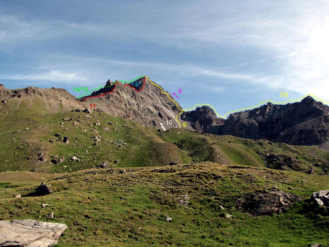
06) - SE Wall Fénis's: (from Barche - Clavalité - (of route signals 2 (or 2A between Lovignana/Marqueron) and 5) Val Fénis Meney (1.949m) and Grand'Alpe Pastures (2.120m) - "High Great Comba" Tersiva's, by route's signal n° 6 - Grand Raye or Reye = Great Balcony/Dress circle) to face's base quota 3.060/70 meters): unknown; diff. in lev. 2.950m from Barche; 2.400m from Lovignana Alp (1.169m); 1.400m from Grand'Alpe; 450/60m (t. part); PD-/PD/PD+?.(See route 03).
Priv. inf., by Battista Pieiller Nov./Dec., 2009 and Jan 18th, 2010. (Besides see route 03 and in "PARCO NAZIONALE DEL GRAN PARADISO", by Giulio Berutto in page 84 "A 32 GIRO DELL'ALTA VALLE DI CHAMPORCHER: LAGO MISERIN - FINESTRA DI CHAMPORCHER - COLLI FENIS E PONTONNET" and in page 94 "TRAVERSATA DAL PIANO DI CLAVALITE' AL RIFUGIO MISERIN PER IL COL FENIS 2.831m". iN PAGE 96 "B 9 TRAVERSATA DAL PIANO DI CLAVALITE' A LILLAZ PER I COLLI FENIS E PONTONNET 2.897m". Edit. Istituto Geografico Caentrale Torino in Turin, Nov 1981; reprint in Turin Jun 2000).
06)bis - E-SE Slope "Grand Raye's" Route; Fénis's Normal Route: (from Fénis-Barche - Robbio in the Clavalité's Tableland - Grand Alp in the Val Fénis - "High Great Comba" Tersiva's (roads signals n°2/5/6) - Grand Raye (Dress Circle) to quota 3.060/70 meters around at base of theGrand Raye's Great Couloir and Pass (3.457m) and terminal part S-SE Crest's): unknown. Old normal Route for Fénis's mountaineers. First ascent: unknown; diff. in level from Barche 2.950m; from Lovignana 2.400m; from Grand'Alpe 1.400m; Raye's Great Couloir (Gully) 400m and 55/60m around in SW Crest in terminal part PD-/PD/PD+.
VARIANT of opening and departure by of the route signals HIGH ROUTE 2 and 8A in term. part from crossroads 2.540/5m around (From Champorcher Village Chateau: "Chemin du Roi", erect in the end of nineteenth century - Gontier/Byron/Arbussey/Collin/Petit and Grand Mont Blanc (1.683m)/La Cort Villages - two littles bridges up Peuson's and Raty's Torrents Brenvei Alp - Great Champlong's Tableland Pastures (many old old wooden/rocky "rascards" in the verdant plain, scattereds between and amongst Cyclopian rocks hasty from vertical South Wall of the Bec Raty 2.382m)Leytuerie Alp (2.066m) to Dondena Alps (of arrival possibility by motor vehicles along a dirt road) and from Dondena - little bridge upon Ayasse's Great Torrent - Dondena's " Albergo (near ruines old barrack-like building of the Austrian Army Corps in Napoleonics Wars) and Refuge (2.193m) - little bridge in crossroads 2.340/50m uponAyasse's Torrent - East Pontonnet's Laketo Fénis's Pass and from - "High Comba" Tersiva - Grand Raye to quota 3.060/70 meters about at of the Great Raye Couloir base - Great Raye Pass 3.457m) and terminal part. S-SE Crest's: Abbot Don Noussan of Champorcher; ? th?, 1912: d. in lev. 2.950m/2.400m/1.400m/400m and 55/60m around in terminal crest. Great Raye's Couloir in snow, 35°/38°/42°; F+ or, snowy, PD/PD-.(See route 03).
Priv. inf., remarks, reports and connections by Battista Pieiller 2009/2010. (Besides see routes 01 and 03).
FROM CHAMPORCHER - COGNE ROUTES
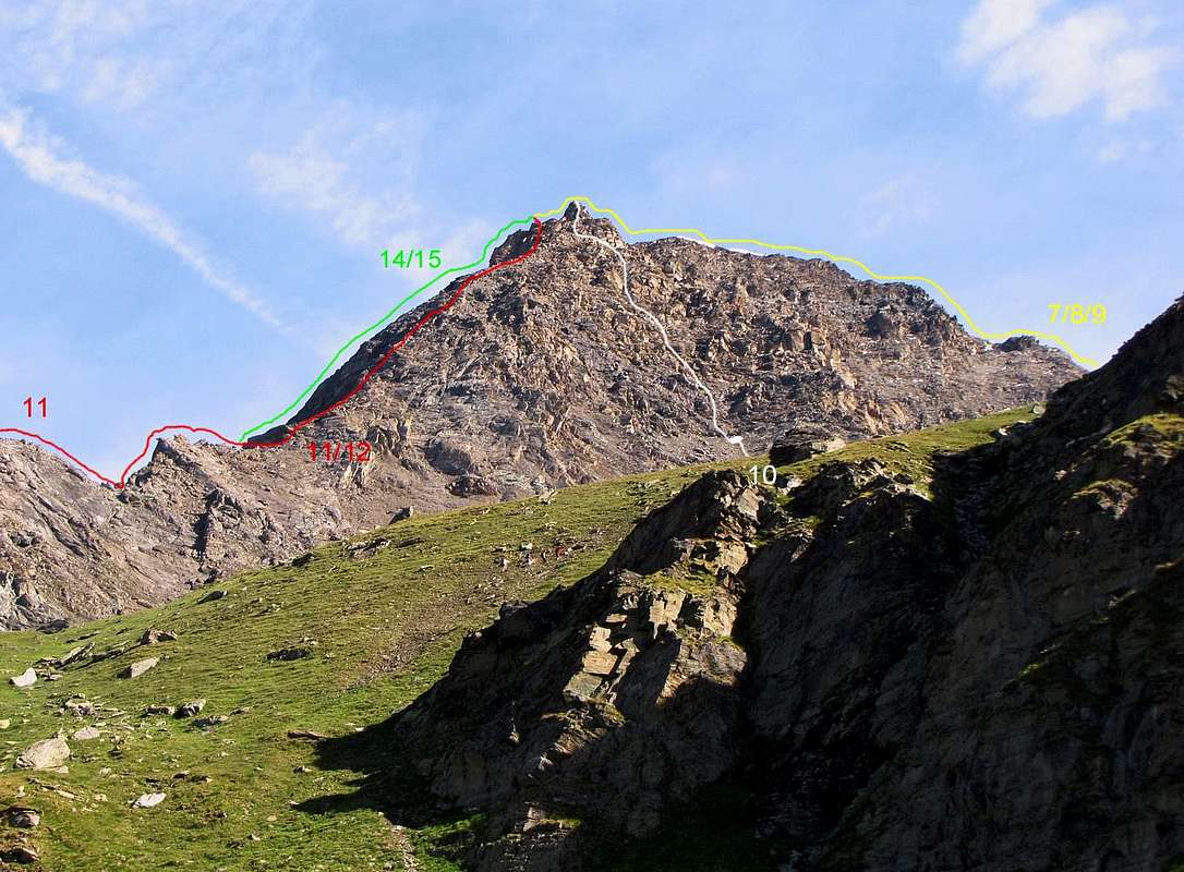
07) – S-SE Arête,"Pontonnet's Crest": (from Champorcher Village also called from Dondena Alps by "Chemin du Roi" (=King's Route). From Champorcher/Chateau: Byron/Arbussey/Petit-Grand Mont Blanc/La Cort Villages - Champlong Alps to Dondena Alps. From Dondena - Dondena's Refuge - crossroads 2.345m and little bridge up Ayasse's Torrent - crossroads 2.545m between to Moutsaillon and Fénis Pass - East Pontonnet's Laketo Pontonnet's Pass (2.992m). From Pass - Tour Pontonnet (South, 3.174m, and North, 3.185m, Summits) to 3.145m Pass (little saddle) and S-SE Crest): Don Noussan, Parish Priest of Champorcher; diff. in lev. 2.300/50m from Champorcher/"Castello"; 1.550/600m from Dondena's Alps (2.097m); 880/920m from Pontonnet's Pass; 370/80m in t. part from little saddle 3.150m); (II°+/III°/II°-) PD+/AD+/PD-.
"Statistica delle prime ascensioni nel Gruppo del Gran Paradiso", in Bollettino 1908 Vol. XXXIX°, n. 72 -Bulletin C.A.I. 1908, by Agostino Ferrari, pages 101/55. Edit. C.A.I. in Turin 1908. "La Valle di Champorcher", by Mario Aldrovandi. Edit. Lattes in Turin, 1930/32. "GUIDA della REGIONE AUTONOMA della VALLE D'AOSTA", by Mario Aldrovandi, page 195. Edit. S.P.E. of Carlo Fanton in Turin, Dec 31th, 1964. Guida dei Monti d'Italia "Emilius Rosa dei Banchi Parco del M. Avic", by Giulio Berutto and Lino Fornelli, page 159. Edit. C.A.I./T.C.I. in Milan, Mar, 2005.
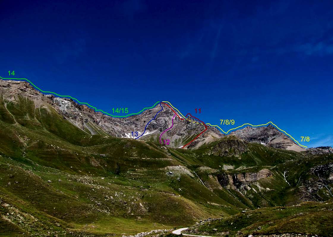
08) – S-SE Arête,"Pontonnet Crest": (from Lillaz (Cogne's Village) - Urtier Valley: Goilles Dessus Little Village - "Crest's Chapel" (fountain) and Old Alp (ruins) - Tsavanis' Waterfall and Alp - little bridge 2.360m in Urtier's Torrent - Pianas's/Invergneux's Alps - "Of Hunters Baita (= priv. Alpine Refuge hunters's) Orlando" 2.641m (near Ponton Alp) - West Pontonnet's three littles Lakesto Pontonnet's Pass. From Pass (2.992m) - Tour Pontonnet South and North Summits to 3.150m Pass and S-SE Ridge): unknown; d. in lev. 2.000m from Lillaz Village (1.612m; Parking); 1.580/600m from Crest Alp and Chapel; 960/70m from Hunters "Baita" Orlando; 880/920m from Pontonnet's Pass; 370/80m in t. part from little saddle 3.145m); (II°+/III°/I°-) PD+/AD+/PD-.
(See above 1908, 1930/2, 1964 and 2005).
FROM COGNE URTIER VALLEY ROUTES
09) – S-SE Arête "Pontonnet's Lakes's": (from Lillaz (Cogne's Village) - Urtier Valley - Crest Alp (ruins) and "Alpino's Chapel" (fountain) - Tsavanis's Waterfall and Alp - little bridge 2.360m Pianas's/Invergneux's Alps - "Hunters's Baita Orlando" (crossroads 2.641m near Ponton Alp and Lake) - Pontonnet's Valley - Pontonnet's West Lakes (three) - little Comba Pontonnet's to 3.145m Unominated Pass (little saddle) (Pontonnet's Towers Pass? New toponym possible) and to S-SE Crest.): J. A. Garth-Marshall, P. Giacosa and Eliseo Jeantet, mountain's guide of Cogne; Jul, 1872; diff. in lev. 1.850m from Lillaz; 370m in t. part from little saddle 3.150m); (II°/III°) PD+/AD-/PD-.
(See above routes 07 and 08),
10)– S Wall "Pontonnet's West three littles Lakes's Face": (from Lillaz (Cogne Village) - Urtier Valley: Crest "Alpino's Chapel" (fountain) - Tsavanis's Waterfall and Alp - little bridge 2.360m Pianas's/Invergneux's Alps - "Hunters's Baita Orlando" near Ponton Alp and Lake - Pontonnet's Valley and little combato wall's base quota 2.980 meters): Domenico Glarey, Eligio Gontier, Nestore Gontier and Ilario Jeantet mountaineers of Cogne or Champorcher?; Jul 25th, 1952; d. in lev. 1.850m from Lillaz; 530m in t. part; (II°+/III°?) PD+/AD-/PD-?.
"Tersiva's Summit Book 1921/74", property of Osvaldo Cardellina (See Books). 1921/1974. Guida dei Monti d'Italia "Emilius Rosa dei Banchi Parco del M. Avic", by Giulio Berutto and Lino Fornelli, page 159. Edit. C.A.I./T.C.I. in Milan, Mar 2005,
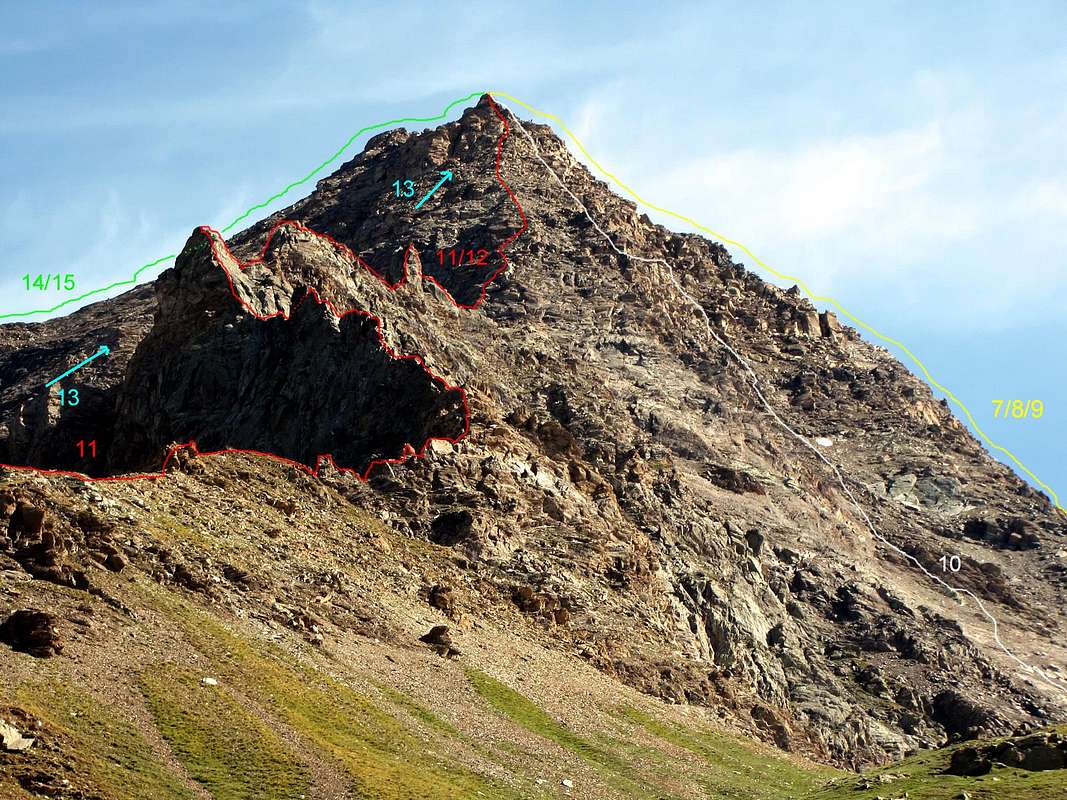
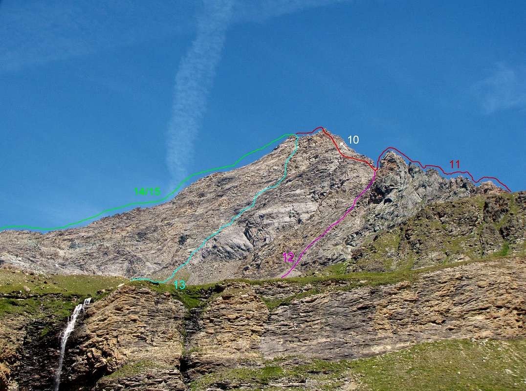
11)– S-SW Arête "Plan Cerise's Crest": (from Lillaz Cogne's Village) - Urtier Valley: Crest Alp (ruins) and "Alpino's Chapel" (fountain) - Tsavanis's Waterfall and Alp - little bridge Pianas's/Invergneux's Alps - Plan Cerise to ridge's base quota 2.800/900 meters): I°? G. Cavagnet and F. Santi; Aug th?, 1895; d. in lev. 1.850m; 800m in t. part); (II°/V°?) AD-/D+.
"RM C.A.I. 1901, page 400. Edit. C.A.I. in Turin, 1901. Guida dei Monti d'Italia "Emilius Rosa dei Banchi Parco del M. Avic", by Giulio Berutto and Lino Fornelli, page 160. Edit. C.A.I./T.C.I. in Milan, Mar, 2005.
12)– S-SW Arête,"Western VARIANT of Opening":from Lillaz (Cogne's Village) - Urtier Valley: Crest Old Alp (ruins) and "Alpine Troups's Chapel" (fountain) - Tsavanis's Waterfall and Alp - little bridge 2.360m Pianas's and Invergneux's or Hevergnes's also Invergnaou's Alps - little Comba Invergneux's) to ridge's base quota 3.050/80 meters): Don Noussan, Champorcher's Reverend; ? th?, 1912; d. in lev. 1.850m from Lillaz; 400m in t. part); (II°/II+/III°?) AD-?.
"GUIDA della REGIONE AUTONOMA della VALLE D'AOSTA", by Mario Aldrovandi, pages 150, 195. Edit. S.P.E. of Carlo Fanton in Turin Dec 31th, 1964.
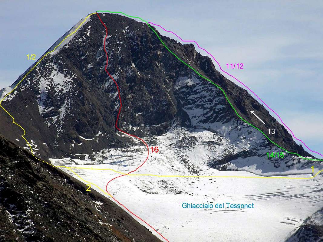
13)– SW Wall:from Lillaz (Cogne's Village) - Urtier Valley: Crest Ancient Alp (ruins) and "Alpino's Chapel" (fountain) - Tsavanis's Waterfall and Alp - little bridge Pianas's /Invergneux's Alp - "little Comba" Invergneux'sto face's base quota 3.050/70 meters): L. Marchelli, R. Marchelli and L. Jeantet; Sep 01th, 1898; d. in lev. 1.850m; 450m in t. part; (II°+/III°) AD.
"RM C.A.I. 1899, page 461. Edit. C.A.I. in Turin 1899. Guida dei Monti d'Italia "Emilius Rosa dei Banchi Parco del M. Avic" by Giulio Berutto and Lino Fornelli, page 160. Edit. C.A.I./T.C.I. in Milan, Mar, 2005.
14)– W-SW Arête "Invergneux Crest": (from Lillaz - Urtier Valley: "Crest's Chapel" and fountain - Tsavanis's Waterfall and Alp - little bridge 2.360m in of the Urtier Torrent Pianas's/Invergneux's Alps and Invergneux's Pass - Serra Madù or Madou 3.220mto little saddle 3.198m, of the ridge base quota 3.240/5 meters): Abbé Pietro Baldassare Chamonin and one unknown student; Aug 23th, 1842; d. in lev. 1.950m from Lillaz; 300m in t. part); (I°/II°+/III°-) PD-/PD+/PD-.
(See above routes 01, 01bis and 02).
14)bis- W-SW Crest VARIANT of Opening Plan Cerise's: (from Lillaz (Cogne's Village) - Urtier Valley: "Crest's Chapel" fountain - Tsavanis's Waterfall and Alp - little bridge in Urtier's Torrent Pianas's/Invergneux's Alps - Plan Cerise - S-SE Slope Madù or Madou Serra's to little saddle 3.198m and crest's base quota 3.240/5 meters): Surveyor Ercole Piana; ? th?, ?; d. in level 1.950m from Lillaz; 450m in t. part); (I°/II°/II°+?) PD/PD+?.
"GUIDA della REGIONE AUTONOMA della VALLE D'AOSTA", by Mario Aldrovandi, pages 150 and 195. Edit. S.P.E. of Carlo Fanton in Turin Dec 31th, 1964.
FROM COGNE GRAUSON/DOREIRE VALLEY ROUTES
15) – W Arête "Grauson's/Doreire's Crest": (from Gimillan Village (little bridge 1.840m in NE of the village) - Tzecheu Lower Alp - Ecloseur Bridge upon Lussert'/Doreire's Torrents and twelte Alps (source between little wood and near Lussert'/Doreire's Torrents) - Pila Alp and Waterfall - Grauson Vieux Alp (Pré Vau-dan's Source near little bridge on Ervilliéres "Ru" (=little torrent) to Pastures and privates refuges) - Grauson/Doreire Valley: Pralognan Alp - Ervillères Alp - sections of left (North) and high central (East) Tessonet/Doreire Glacier's) - "Colletto" (=little pass) 3.198mbetween Serra Madou and Tersiva Point, to ridge's base quota 3.240/5 meters): Unknown; d. in lev. 1.900m from Gimillan Village; 270m in t. part); (I°/II°+/III°-) PD-/PD+/PD-.
(See route 01, 01bis and 02).
16)– NW Wall: (from little bridge 1840m c. in NE Gimillan Village's - Reventis Alp (ruins) - Ecloseur little Chapel - Tzecheu Lower Alp - Ecloseur's Bridge (source in little wood near Lussert Stream) - Ecloseur Alps - Pila Alp and Waterfallss - Créuzet Alp ("Bergamaschi's" privates Hut) - Grauson Vieux Alp (=Old Great Valley) - Grauson/Doreire Valley: Bridge 2.298m on Money's and various torrents - Pralognan Alp - Ervillerès Alp - sections North (left) and East (high central) in the middle area of the Tessonet/Doreire Glacier's to face's base quota 3.170/80 meters): Osvaldo Cardellina, solo; Sep 10th, 1988; d. in lev. 1.950m from Gimillan; 330/40m in t. part); (35°/40°/45°); AD-/AD+/PD+.
"Diari Alpinistici di Osvaldo Cardellina Ascensioni 1964/2013" - "Mountain's Diarys by Osvaldo Cardellina Ascents 1964/2013" with General Index 1964/2010 and Report's File since Sep 03th, 1964 until Mar, 2010. Guida dei Monti d'Italia "Emilius Rosa dei Banchi Parco del M. Avic", by Giulio Berutto and Lino Fornelli, page 160. Edit. C.A.I./T.C.I. in Milan, Mar, 2005. Thesis "Variazioni Glaciali nel Gruppo del Monte Emilius" (e della Tersiva), by Alessandro Giusto Cardellina. Studys's University of Turin, Naturals Sciences Faculty, Course/Degree. Apr 24th, 2009.(Besides see routes 01 and 02).
TERSIVA IN WINTER (in detail books, privates informations, remarks and reports)
1875: first in winter ( from Grauson/Doreire Valley and N-NW Arête): Giuseppe Corona & company; 17.02.1875. ("l'Alpinista" 1875/7, page 106. "Bollettino" of C.A.I.1903/69, page 15. Guida dei Monti d'Italia C.A.I./T.C.I."Emilius Rosa dei Banchi Parco del M. Avic", by Giulio Berutto and Lino Fornelli, page 156. Edit. Mar 2005).
1921: ? Arête (from?): Aldo Bonacossa & company; ? th ? 1921; skiing. ( "Bonacossa Book"; Guida dei Monti d'Italia C.A.I./T.C.I."Emilius Rosa dei Banchi Parco del M. Avic",by Giulio Berutto and Lino Fornelli, page 156. Edit. Mar 2005).
1930:W Arête ( from Urtier Valley - Invergneux Pass and Serra Madù or Madou 3.220m): Mario Aldrovandi and wife and Giuseppe Vassoney, mountain guide of Champorcher; ? 01.1930; skiing. ("Guida della Valle di Champorcher" by Mario Aldrovandi. Edit. Lattes Turin's, 1930/32. "Guida della Valle di Cogne" by Mario Adrovandi. Edit. Lattes Turin's, 1930/32. "Guida della Regione Autonoma della Valle d'Aosta" by Mario Aldrovandi, pages 150, 195 and 289. Edit. S.P.E. Carlo Fanton's of Turin, Dec 31th, 1964).
1980:N Wall and NE Arête ( from Barche - Clavalité - Fénis Valley - Private Refuge Turati - "High Little Comba" Tersiva's): Maurizio Gaillard, mountain's guide of Valpelline, and Sergio Pession; Dec 26/27 th, 1980. ("Montagnes Valdôtaines" - Magazine Section's C.A.I. of Aosta, Year VII n° 1 (17) May 1981, page 7) (or 27/28 th, 1980, by priv. inform., remarks and reports 2009, by Maurice Gaillard of Fénis and Sergio Pession of Quart).
1984:N Wall Right Route ( from Barche - Clavalité - Fénis Valley - Tersiva's "High Little "Comba"): Maurizio Gaillard, mountain's guide Valpelline's, and Sergio Pession; 04.01.1984. (priv. inform., remarks and reports 2009, by Maurice Gaillard, of Fénis and Sergio Pession of Quart).
Noteworthy ascents at the beginning sprigtime(*):or in lateFall(**).
1921: Ascension of Bonacossa & company; from? skiing. (Bonacossa Book).
1942:N-NW Arête and E Slope Tersiva Pass's; in ascent from? in descent from Tersiva's Pass: Toni Ortelli, Venturello, Zangelmi & company; 25.04.1942; skiing. ( "Storia dello Ski Club Torino e le origini dello sci in Italia": Edit. Ski Club Torino, 1971).
1979:N-NW Arête (from Saint Marcel Valley - High Les Druges - Mulac Hunting House - Plan Rué Alp - Grande Chaux Turati's Hunting House - "Colletto" (Little Pass) Tessonet - Grauson/Doreire Valley - Tessonet Glacier to Tersiva Pass): Maurice Gaillard, Valpelline's mountain'guide, Sergio Pession, of Quart, and Nilo Pieiller), of Fénis; May 27th, 1979; skiing.
("a piedi in VALLE D'AOSTA VOL. II 116 passeggiate, escursioni e trekking alla scoperta della natura" , by Stefano Ardito, page 182 (route 610 "Da Les Druges al Vallone di Saint Marcel"). B&W Map 1 Km:1 cm vith tracks of routes in page 184 extant. Edit. GUIDE ITER in Subiaco (Rome) Jun 2004. Priv. inform., remarks and reports 2009 by Maurice Gaillard and Sergio Pession).
BOOKS AND MAPS (Detailed Bibliography)
BOOKS:
(Twentysix Books, five Documents and one Graduation Thesis)
"Guida delle Alpi Occidentali Vol. II. Graie e Pennine Parte Seconda Le Valli di Aosta, di Biella, della Sesia e dell'Ossola", by Giovanni Bobba and Luigi Vaccarone, pages 65/6: "Invergneux's Pass", in page 57; "Pontonnet's Pass and Lakes", 36/7. "Tessonet's/Doreire's Glacier", page 36. Edit. from Section of C.A.I. Turin's in Turin, 25 May 1896. Reprint Arti Grafiche Tamari in Bologna, Jan, 1974.
"Guida della Valle di Champorcher" and "Guida della Valle di Cogne", by Mario Aldrovandi. Edit. from Lattes Torino in Turin, 1930-1932.
"Guida della Regione Autonoma Valle d'Aosta", by Mario Aldrovandi,in pages 150, 195 and 289. First Edit. S.P.E. di Carlo Fanton Torino in Turin, Dec 31th, 1964. Second Edit. (Reprint) 1975.
"Nouveau Guide de la VALLEE D'AOSTE" and "Nuova Guida della VALLE D'AOSTA", by Renato Willien (texts, text's translation into French by M.me Lucienne Landi) and Franz Schwetz, Hans Oberbacher and Aldo Cigheri (geoplastigraphics, geotourist and toponymics maps), pages 184/193 ("Fondovalle da Aosta ad Aymaville - Valley floor from Aosta to Aymaville, with n° 12 cololorphotos and n° 1 geoplasticgraphic" and 194/208 "Valle di Cogne - Cogne's Valley", with n° 11 colorspictures and n° 1 B&W sketch-draft 1:100.000. Edit. SAIGA PARAGON of Genova and S.A.C.A.T. s.n.c. of Turin. Colorphotographs by Renato Willien and SAIGA PARAGON S.A.C.A.T. - Torino. Edit. in Turin "en l'an 1968".
"GRAN PARADISO Itinerari scelti alpinistici ed escursionistici del versante valdostano", by Pierandrea Mantovani and Renato Misischi, pages 24/5 "Tersiva 3515m 1", (route n° 1 d.d.r.). B&W particular Map 1:50.000 (2cm:1.000m), extant in page 22. Edit. RASSEGNA ALPINA in Milan, Jun, 1974.
"80 itinerari di escursionismo alpinismo e sci alpinismo in valle d'aosta", by Osvaldo Cardellina, pages 86/7. B&W Map 1:25.000 in page 88 extant. First Edit. Musumeci in Aosta, Jun, 1977 (in Italian). Second Edit. Jul, 1981. Third Edit. Jul, 1984. In French, First Edit., Feb, 1978; second Edit., Mar, 1980.
"Le Valli del GRAN PARADISO", by Giuseppe Lucca, pages 17/51 "La Valle di Cogne". Particular Maps 02cm:2km extant in pages 14/15, by Marco Cossard. Edit. Musumeci in Aosta, Jul, 1977.
"La Vallée d'Aoste dans votre poche", by Giuseppe Lucca, pages 43/44 "Aymavilles"; B&w n° 1 picture extant. Pages 45/7 "Cogne". Version (translation from Italian in French) M.me Lucienne Landi. Edit. Musumeci in Aosta, 1978.
"DAL MONVISO AL SEMPIONE 105 gite con gli sci in Val d'Aosta, Susa, Lanzo, Ossola e altre undici nelle Alpi Occidentali", by Roberto Aruga and Cesare Poma, pages 106/7 "46 - Punta Tersiva 3.515m". B&W photograph, with track in page 107. Particular Map 2,7cm: 2Km extant in page 106. Edit. CDA - Centro di Documentazione Alpina - Torino in Leynì (Turin), May, 1979.
GUIDE I.G.C, "IL PARCO NAZIONALE DEL GRAN PARADISO Vol. 2° Valli di Champorcher - Clavalité - Saint Marcel - Laures - Cogne - Valsavarenche - Conca di Pila Volume II 165 itinerari di montagna 32 gite sci-alpinistiche", by Giulio Berutto, pages 92 "B6 Traversata dal Piano di Clavalité a Dondena per il Col Fussì 2.912m"; in page 94 "B7 Traversata dal Piano di Clavalité al Rifugio Miserin per il Col Fénis 2.831m". B&W action's photo in page 93. "B9 Traversata dal Piano di Clavalité a Lillaz per i Colli Fénis e Pontonnet 2.897m", page 96. " D7 Traversata dal Vallone di Laures a Gimillan per il Colle di Laures 3.036m". Page 148 "F11 Bivacco Grauson-Tentori 2.540m"; B&W picture in page 149 (from Ecloseur Bridge and Alp to Pila Alp and Waterfulls. Pages 158/160 "F18 Punta Tersiva 3515 m" ; 160 " F19 Traversata dal Bivacco Grauson a Lillaz per il Passo d'Invergneux 2.905m". B&W sketch-draft in page 160 (Punta Tersiva from Grauson's Valley). Page 166 "F23 Punta Tersiva 3.515m"; 167 B&W picture and "F24 Traversata da Lillaz al Piano di Clavalité per i Colli Pontonnet 2.897m e Fénis". Ski-mountaineering routes "N 3 Punta Tersiva 3.515m" in page 287. Edit. Istituto Geografico Centrale di Torino in Turin, 1981. Reprint Jun, 2000.
"Guida ai rifugi e bivacchi in Valle d'Aosta", by Cosimo Zappelli, pages 09/112 "Gruppo della Tersiva e Rosa dei Banchi". B&W n°1 picture extant. Particulars, 2cm:2km, Maps B&W and tracks in red extants, by Marco Cossard. In pages 94/5 "(Cogne") and 110 "(P. Tersiva - M. Glacier - Rosa dei Banchi)". Edit. Musumeci in Aosta, Summer 1979.
"Gran Paradiso itinerari alpinistici e sci-alpinistici", by Franco Brevini, pages 52/4 "P. Tersiva 1a Versante sud e cresta nord-ovest Via normale dall'Urtier; 1b Versante ovest e cresta nord-ovest Via normale dal Grauson". "Interesting ascents" in page 22."Difficultys's of routes classification" in page 23. In Second Part "Itinerari sci-alpinistici" - "Mountaineerig Ski routes" pages 192/3 "1 Punta Tersiva 3.515m" and "Of routes Classification" in page 191. Edit. Musumeci in Aosta, Jun 1982.
"Gran Paradiso itinerari escursionistici", by Franco Brevini, pages 4/5 "4 Gimillan 1.787m Alpe Pila 2.025m" and in Index "Un'ora". Pages 116/7 " 55 Traversata Gimillan 1.787m Vallone del Grauson Passo di Invergneux 2.902m Vallone dell'Urtier Lillaz 1.617m" and in Card-Index " 55 Sei ore". General Colormap and tracks in red "Carta d'insieme" in pages 16/7 and Particular Colormaps and tracks in red: "(Carta A, Carta B, Carta D and Carta E)" 1:25.000, by Marco Cossard in pages 18/19; 20/21; 24/25 and 26/27. Edit. Musumeci in Aosta, Jul 1982.
"Guide des refuges et des refuges-bivouacs de la Vallée d'Aoste", by Cosimo Zappelli, pages 109/112 "Groupe de la Tersiva et Rosa dei Banchi". B&W n° 1 picture. Particular Map and in red track , 2cm:2km, by Marco Cossard in page 110 "Punta Tersiva". Edit. Musumeci in Aosta, "Achevé d'imprimer en Juillet 1982".
"VALLE D'AOSTA LE GRANDI ESCURSIONI Alte Vie N. 1 e N. 2 22 Itinerari di valle", by and Palmira Orsières, pages 104/106 "Valle di Champorcher" and pages 107/111 "1° tappa:Champorcher - Cogne". In pages 112/113 "Variante alla 1° tappa:Vallone del Grauson" and in pages 114/116 "Valle di Cogne". B&W action's photos in pages 105, 108, 113; B&W pictures in pages 109, 112 and 115. Colorphotos action's and picture n° 5 in pages 106, 107, 110 and 111. Edit. C.D.A. Centro di Documentazione Alpina Turin's in Turin, Jun 1985.
"Il Parco Nazionale del Gran Paradiso", by Walter Giuliano, pages 1/190. Edit. Giunti Martello in Florence, 1985.
"Andar per sentieri in VALLE D'AOSTA 70 itinerari", by Pietro Giglio, with collaboration by Palmira Orsières, pages 47/8. "La Valle di Cogne All'ombra del Gran Paradiso 2 Il Passo d'Invegneux nel Vallone del Grauson". B&W picture in existence (Grauson's Alp and torrent), in page 47. Edit. Istituto Geografico De Agostini, Novara in Novara, 1989.
"DALLE MARITTIME AL VALLESE CENTO ITINERARI SCIALPINISTICI meno conosciuti sulle Alpi Occidentali" , by Scuola Nazionale Scialpinismo SUCAI-Torino Edited by Roberto Marocchino, Ezio Mentigazzi and Roberto Scala, pages 170/1 "75 - Traversata Champorcher-Fenis". B&W action's snap in page 171. Particular Map 2,7cm:4km. with of route track in page 170. "Of routes Difficulty's Marking", in pages 232/3. Edit. CDA Centro Documentazione Alpina-Torino in Turin by AGES Graphics Works Turin, Dec 1982.
"VALLE d'AOSTA oltre il sentiero 60 itinerari di escursionismo impegnativo e di alpinismo facile dal Mont Avic al Monte Bianco" by Pietro Giglio - Matteo Giglio, pages 42/4 "3 Punta Tersiva 3.515m (via normale della cresta nord ovest)". B&W pictures in pages 42 and 44. Edit. CDA Centro Documentazione Alpina Torino in Turin, Mar 1993.
"Diario Alpinistico di Amilcare Crétier Ascensioni in Valle d'Aosta 1921-1933" - "Mountain's Diary in Aosta's Valley Ascents 1921-1933",by Amilcare Crétier,page 23. Edit.Nuovi Sentieri from Section Verrés's of the C.A.I. and Library Verrés's Stampa Arti Grafiche Tamari in Bologna, Jul 1993 (in Italian).
Guide d'Italia De Agostini "Valle d'Aosta", by Various Writers ; Texts by Ombretta Levati, Pietro Giglio and Franco Fini (FF). Specifically"La Valle di Champorcher", pages 192/7; n° 2 colorpictures."La valle di Cogne", pages 200/33; n° 11 colorpictures. In particular "Al Passo d'Invergneux" in page 214. "Alla Punta Tersiva" in page 218. "Itinerari di sci alpinismo da Gimillan Alla Punta Tersiva". Color Map 1:115.000, by Istituto Geografico De Agostini Novara, enclosed. Edit. Istituto Geografico De Agostini Novara, 1996.
"Dove si specchia il cielo I LAGHI DELLA VALLE D'AOSTA 185 itinerari che conducono a oltre 220 laghi", by Sergio Piotti, pages 73/89 "La Val di Cogne"; n° 10 colorphotos. Edit. Ferrari in Clusone (Bergamo), Jul 1996. Reprint Mar 1997.
"PARCO NAZIONALE DEL GRAN PARADISO", by Stefano Ardito,pages various. Colorgeneral Map 1:200.000 in pages 6/7. Edit GUIDE ITER in Subiaco (Rome), Nov 2001.
"i Rifugi della Valle d'Aosta 113 rifugi e bivacchi Itinerari. Informazioni. Consigli utili ", by Stefano Ardito, pages 236/7. Generals colors Maps 1:50.000 in pages 14/5; "Bivacco Carlo Tentori". Edit. GUIDE ITER Graphics Works "Il Torchio" in Subiaco (Rome), Feb 2003.
"a piedi in Valle d'Aosta 132 passeggiate, escursioni e trekking alla scoperta della natura", Vol. 2, by Stefano Ardito, itinerari (routes) 729/30 in pages 226/28. Edit. GUIDE ITER in Subiaco (Rome), Jun 2004.
Guida dei Monti d'Italia – "Emilius Rosa dei Banchi Parco del M. Avic", by Giulio Berutto and Lino Fornelli, in pages 156/160; Tersiva's Pass in pages 155/6; Invergneux's Pass in pages160/1; Pontonnet's Pass and Tower in pages 164/5. Edit. Club Alpino Italiano/Touring Club Italiano in Milan, Mar 2005 (in Italian).
"Gran Paradiso Gabietsfuhrer fur Wanderer, Bergsteiger und Kletterer", by Gerd Klotz, page 224 "615 Punta Tersiva, 3.515m 616 Nordnordwestgrat"; B&W photograph and of route track in page 225. General colours Map 1:100.000 in pages 00/001. Edit. BERGVERLAG ROTHER GMBH MUNCHEN, Auflage 2005. Bad Orb, im Fruhjahr 2005.
"Diari Alpinistici 1964/2013" - "Mountain's Diarys 1964/2010", by Osvaldo Cardellina and "Indice Generale" - "General Index 1964/2013", with "Schedario Relazioni Ascensioni 1964/2013" - "Reports's of Ascents 1964/2013" , (inediti-unpublished).
"Libro di vetta della Tersiva" - "Summit's Book 1921/1974" since Aug 18th, 1921 until Sep 08th, 1974, archives by Osvaldo Cardellina, (inedito-unpublished)</font/>.
"Soles Documents Summit's", retrouved by Osvaldo Cardellina in Summit in bad weather and storm, Sep 08th, 1974:
1): "Tersiva : 5 Settembre 1937 Prima Direttissima della Parete Nord - est della Punta Tersiva...88° Compagnia Alpini Scuola - Alpina..."Tersiva's Point First Ascent of Superdirect Route North - east Face's of Punta Tersiva ... 88° Company - Alpine Troups - School"..., by Luigi "Gigi" Panei, of Courmayeur, and Lucien Salval, of Aosta. Return Original Copy from Osvaldo Cardellina to Salval Family; in my possession of duble copy reproduction.
2): "Traversata in due giorni da Fernier (Pila) - Col Valaisan - Torre Grauson - Ervillières - Tersiva, in andata e ritorno"..."Crossing in two days from Fernier (Pila) -Valaisan's Pass - Grauson's Tower - Ervillières Alp to Tersiva's Point, round trip"..., by Anselme "Ansel" Falcoz, Aug 1930. Original Copy in existence by Osvaldo Cardellina.
"Tersiva of the Summit Book since Aug 14th, 2004 until Jul 26th, 2009" (unpublished). Property by Battista Pieiller, of Fénis; (unpublished).
"Variazioni Glaciali nel Gruppo del Monte Emilius" (e della Tersiva) - "Glacials Variations in the Mount Emilius's Mountain Chain" ( and of Tersiva's Point ), by Alessandro Giusto Cardellina, pages 1/184. In pages 93/137 "Ghiacciaio del Tessonet Meridionale"; in pages 139/161 "Ghiacciaio Tersiva". Graduation thesis disputed in Study's University of Turin, Faculty of the Mathematicals, Phisics and Naturals Sciences / in Naturals Sciences Course-Degree, Supervisor Prof. Michele Motta. In Turin Apr 24th, 2009 (unpublished).
PRIVATES INFORMATIONS, REPORTS, REMARKS and CONNECTIONS by:
Emilio BERTONA, mountaineer and alpine photographer of Aosta; Alessandro Giusto CARDELLINA, research worker naturalist, phisiotherapist and Author-Writer of Graduation Thesis "Variazioni Glaciali nel Gruppo del Monte Emilius" (e della Tersiva) of Pian Felina (Charvensod)/Coutateppaz (Saint Christophe); Anselme FALCOZ, mountaineer and ski-mountaineer of Aosta; Camillo Roberto FERRONATO, mountaineer and "christallier" or mineralogist (minerals digger) of Pian Felina (Charvensod); Maurice GAILLARD, Valpelline's mountain's guide of Fénis; Danilo GARZOTTO, mountaineer and tripper-hiker of Pian Felina (Charvensod); Antonio GIANI, mountaineer and alpine photographer of Saint Christophe; Renzo JEANTET, mountain's guide of Cogne and ski-mountaineer; Vincenzo PERRUCHON, mountain's guide of Cogne, ski mountaineer, log-distance runner and hunter; Sergio PESSION, mountaineer, ski-mountaineer and hunter of Quart; Battista PIEILLER, mountaineer and ski-mountaineer of Fénis; Ezio SAVIN, mountaineer and ski-mountaineer of Cogne; Gianfranco VICENTINI, mountaineer and tripper-hiker of Aosta.
PHOTOGRAPHICS CONTRIBUTIONS by:
Emilio BERTONA : action's photos of the Aug 05th, 1998; Alessandro Giusto CARDELLINA: action' photos 1983/2010; Camillo Roberto FERRONATO: action's photos of the Sep 08th, 1974; Danilo GARZOTTO : action's photos of the Aug, 18th, 1993; Antonio GIANI; of the ridges and faces basic's Colorpictures of the variaous years; Natalino MASSONI: action's photos of the Aug, 18th, 1993; Battista PIEILLER : action's photos of the Aug, 2009; Gianfranco VICENTINI : action's photos of the Aug, 05th, 1998.
</td
MAPS:
Kompass: "Gran Paradiso Valle d'Aosta" Sentieri e Rifugi-Carta Turistica. 1:50.000.
I.G.C. Istituto Geografico Centrale di Torino: "Gran Paradiso-la Grivola" .Carta Turistica 1:25.000.
I.G.C. Istituto Geografico Centrale di Torino: "Il Parco Nazionale del Gran Paradiso". Carta 1:50.000.
Hapax-Comunità Montana del Monte Emilius: "Les Sentiers".First Edit., Luglio 2000. 1:25.000.
Hapax-Comunità Montana del Monte Emilius 2008: "Les Sentiers". 1:25.000.
L'Escursionista: "Valle di Cogne Carta dei Sentieri". (n° 10). 1:25.000.
L'Escursionista :"Tour de la Vallée de Cogne Grand Paradis", Carta dei sentieri. 1:25.000.
Hapax-Pro Loco di Champorcher: "Les Sentiers de Champorcher". First Edit. Agosto 2001. 1:25.000.
Enrico Editore Ivrea-Aosta: "Gruppo del Gran Paradiso". 1:50.000.
The fundamental support given by my friend Antonio Giani. In addition I want to thank Prof. Ferrari Liana for the translation of the text (Overview) from italian.


 19250 Hits
 90.81% Score
 33 Votes


 </td
</td
