
|
|
Mountain/Rock |
|---|---|
|
|
33.73005°N / 116.64147°W |
|
|
Riverside |
|
|
Hiking, Mountaineering, Bouldering, Scrambling |
|
|
Spring, Summer, Fall, Winter |
|
|
7679 ft / 2341 m |
|
|
![]() Overview
Overview
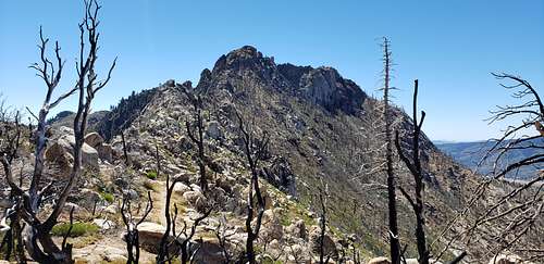
Antsell Rock was named for an artist who was allegedly painting a picture of the Desert Divide during the surveying of the region. The name appears on the 1901 Topo map as the only named summit along the long desert ridge. Antsell Rock is the only summit along the chain which requires scrambling and Class 3 climbing. It is not an easy summit to attain, and the route finding can be difficult, even with "ducked" cairns along the two main routes.
Antsell Rock has the distinction of being deceptively closer than it looks from almost every direction. When first spotted along the Desert Divide from the Southbound PCT, it appears only a few short miles away. From Apache Peak, it looks close enough to touch. It is not really close in either case, and perhaps that has more to do with the scrambling needed to attain the summit more than anything else.
Getting There
Spitler Peak Trail 13 miles round trip - 3600' elevation gain
There are three main routes to Antsell Rock: The Spitler Peak Trail, The Zen Mountain Center, and the Southbound PCT.
To reach the Spitler Peak Trail:
Take Highway 74 or 243 to Mountain Center, and head east on Highway 74 for 3.4 miles. Turn left onto Apple Canyon Road which is signed for Hurkey Creek Park. Head up the paved road for 2.6 miles. A turnout and sign for the trail are on the right hand side. Park in the large pullout along the road just south of the trailhead. The trail was reworked and does not appear accurately on topo maps. It begins in a very arid desert ecosystem and quickly climbs into what was once a mixed oak forest. The forest burned almost entirely in the 2013 Mountain Fire and is now an eerie landscape of burnt oak and Manzanita, with desert scrub and chaparral regrowth everywhere. The initial mile is relatively flat, but it begins to gain elevation while switchbacking up to the PCT which sits two thousand feet above the trailhead. From the creek crossing, the trail grows steeper until it nears the PCT. At the PCT, turn north towards the double summit of Apache Peak. The PCT skirts east around Apache, but a use trail continues to the saddle between the summits and onward to rejoin the PCT, follow either route. Just below the summit of Antsell a use trail climbs up the steep gully. It is ducked, loose, and presents some areas with Class 3 climbing, especially towards the top when reaching for the actual summit.
Zen Mountain Center 5.5 miles round trip - 2600' elevation gain
To reach the Yokoji Zen Mountain Center Trailhead:
From Mountain Center, take Highway 74 east for 3.4 miles. Turn north (left) onto Apple Canyon Road for 4.4 miles and park at the trailhead. The Zen Center is private property and access may be closed at any time.
Southbound PCT - 20.4 miles round trip 4500' elevation gain
From Humber Park in Idyllwild, take the Devil's Slide Trail 2.5 miles to Saddle Junction. At Saddle Junction take the second right onto the Caramba Trail for .6 miles to the junction (right) with the Little Tahquitz Valley Trail for .8 miles to the PCT. Turn left onto the PCT and follow it for 5.5 miles. First, the trail ascends gently eastward through pine forest beneath the Tahquitz and Red Tahquitz ridgeline until it turns west and south onto the Desert Divide where it descends mostly gradually along the Desert Divide. There are multiple treefalls currently blocking the route, most of them below South(well) Peak and then 1/2 mile before the ridge a rockfall hazard currently blocks the trail, but is easily traversed witht he help of a rope which has been tied around the hazard.
The North Ridge follows a fairly well ducked route to the large summit block which requires Class 3 climbing.
Route
The two main routes to the top of Antsell Rock are the East Gully and the North Ridge (Sam Fink Trail), both are loose, difficult, not recommended for novices, require scrambling, bushwhacking, and exposed climbing to reach the top. Errors in routefinding are common, and can lead to overwhelming situations for the uninitiated. Falls from the route may prove to be extrememly dangerous and or deadly.
The East Gully sits just below the summit on the PCT and requires scrambling, bushwhacking, climbing along a ducked route gaining 800 feet in elevation. Routefinding can be difficult and rocks are loose. After ascending the gully, class 3 climbing is required and exposure is dangerous.
The North Ridge (Sam Fink Trail - named for the Sierra Club Member who first scouted and recorded it) begins on the PCT just before the trail dips and switchbacks eastward and the face of the rock can be clearly seen southward. This route is farily well ducked, though routefinding is difficult and exposure is dangerous. From the trail to the base can take upwards of one hour to reach.
Red Tape
Wilderness Permits are required.
Adventure Passes are required for parking.
When to Climb
Antsell Rock can be climbed all year long, though in the winter snow and ice make the route even more dangerous. In 2020, an experienced climber lost his life on Antsell Rock.
Camping
Dispersed camping/backpacking can be had along the PCT. There are numerous private and public camping options in Idyllwild and Garner Valley.
https://lakehemetrecreation.com/
https://www.rivcoparks.org/idyllwild-regional-park
https://www.parks.ca.gov/?page_id=636
http://www.idyllwild.com/camping.html
External Links
Table of Contents
