
-
 22968 Hits
-
 91.75% Score
-
 36 Votes
|
|
Area/Range |
|---|---|
|
|
42.28230°N / 123.9645°W |
|
|
Hiking |
|
|
Spring, Summer, Fall, Winter |
|
|
Overview


The Kalmiopsis Wilderness Area and adjacent peaks are in southwest Oregon and is roughly bordered by California to the south, the Pacific Ocean to the west, the Rogue River to the north and Highway 199 to the east. Grants Pass is in the northeast corner of this area and Gold Beach in the northwest corner. Brookings and O’Brien are in the southwest and southeast corners respectfully. All of the area is in the Rogue Siskiyou National Forest
and the heart of the area is covered by the Kalmiopsis Wilderness Area. The northern portion of this area along the Rogue River is also part of the Wild Rogue Wilderness Area. Nearby Summit Post Areas are the Siskiyou Mountains to the south and the Oregon Coast Range to the north.

In addition to the 500,000 acres that were involved in the 2002 Biscuit Fire, 110,000 acres in the northern portion of the Biscuit Fire had burned 15 years earlier in the 1987 Silver Fire. The Kalmiopsis Wilderness Area was created by the original Wilderness Act of 1964 and now covers 179,755 acres. The area within the Kalmiopsis Wilderness includes the headwater basin of the Chetco River, the North Fork Smith River, and a portion of the Illinois River canyon. All these along with the nearby Lower Rogue River are National Wild and Scenic Rivers and are prime steelhead and salmon habitat.
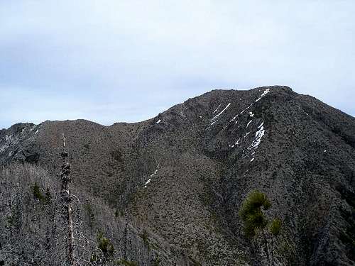
The Kalmiopsis is a harsh, rugged area with a unique character. Elevations range from 500 to 5,098 feet ( Pearsoll Peak). The area is characterized by deep, rough canyons, sharp rock ridges, and clear rushing mountain streams and rivers. Diversity of topography and geology provide excellent habitat for a wide variety of botanical species. The Kalmiopsis leachiana plant was discovered in 1930 by Lilla Leech in the Gold Basin area. The plant is a relic of the pre-ice age and the oldest member of the Health (Ericaceae) Family. The Kalmiopsis Wilderness was named after this unique endemic shrub.
The area is starting to recover from the devastating Biscuit Fire of 2002 with many of the shrubs growing profusely and small seedlings of pine and fir trees making progress. Most of the burned dead trees are still standing sentinels to the devastation. However, 5 years after the fire these snags are starting to give way to nature and can be hazardous to the casual hiker. I probably will not be hiking in the area if a storm is blowing in from the Pacific because of this hazard.
The fire did open up the views so that the unusual and complex geology of the area is visible for your appreciation. Peridotite and serpentine rocks are abundant in the eastern half of the area that is very rich in iron, magnesium, chromium, and nickel. Old gold and chromium mines are prelavent in the wilderrness. The western half of the Kalmiopsis has both igneous intrusive rocks and sedimentary rocks such as shale and sandstone. There is also evidence of glaciation in the Vulcan Peak area.
Getting There

TH#1: Refer to York Butte for directions to the northeast corner of the area. Bald Mountain and Chinaman Hat can be accessed from this road also. Silver Peak is northwest from this area, but can be accessed by following a maze of logging roads.
TH#2: Briggs Creek is accessed from the Illinois River Road from Selma. This trail can access Bald Mountain and go all the way to Agness where the Illinois River and the Rogue River meet.

TH#3: McCaleb Ranch turn off from Illinois River Road. This road is a rocky 4WD road up to Pearsoll Peak. This trailhead can also access the Kalmiopsis Rim Trail, Eagle Mountain, Gold Basin Butte, Nome Peak, Granite Butte, Mount Billingslea, Hayward Peak, Tincup Peak, and Heather Mountain.
TH#4: Eight Dollar Mountain Road between Selma and Cave Junction is a good 2WD road. This road climbs up to the Kalmiopsis Rim Trail and accesses Whetstone Butte, Eagle Mountain, Eight Dollar Mountain, Hungry Hill, Fiddler Mountain, Bailey Mountain, Canyon Peak, and Josephine Mountain.
TH#5: Oregon Mountain Road near the Oregon/California border to access Hawks Rest, Buckskin Mountain, Biscuit Hill,
TH#6: Winchuck River access to Packsaddle Mountain.
TH#7: Chetco River Rd via Devils Backbone to Vulcan Peak, Chetco Peak, Pollywog Butte, Red Butte, and Dry Butte.
TH#8: Chetco River Rd via Long Ridge to Quail Prairie Mountain.
TH#9: Chetco River Rd via High Prairie to Mineral Hill, Green Craggie, Big Craggies, Mislatnah Peak, Johnson Butte, and Snow Camp Mountain.
TH#10: Hunter Creek Rd intersects with Chetco River Rd on the northwest side of the area and there is access here for Fairview Mountain, Jacoby Butte, Collier Butte, Saddle Mountain, Game Lake Peak, Horse Sign Butte, Gray Butte, and Lawson Butte.
TH#11: Bear Camp Rd parallels the south side of the Rogue River from Galice to Agness. Brandy Peak the County Highpoint for Curry County is accessed from this road along with Squirrel Peak, Fish Hook Peak, and Raspberry Mountain.
Trail Information


Red Tape / Contact Information
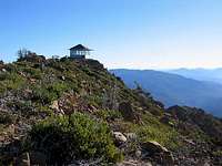
[img:346547:alignright:small:]There is no Red Tape to speak of to hike in this area. The Northwest Forest Pass is not required anywhere in the Rogue Siskiyou National Forest. For a complete list of regulations in the wilderness areas refer to General Wilderness Prohibitions published by the forest service concerning motorized vehicles, dogs, firearms, and campfires.Contact the Rogue Siskiyou National Forest for further information and questions
[img:355937:alignright:medium:]
Gold Beach Ranger District
John Borton, District Ranger
29279 Ellensburg Ave
Gold Beach, OR 97444
Phone Gold Beach:
Voice: (541) 247-3600
Fax : (541) 247-3617
TTY: (541) 247-3605
P.O. Box 4580, 539 Chetco Ave
Brookings, OR 97415
Phone Brookings (Chetco):
Voice: (541) 412-6000
Fax : (541) 412-6025
Wild Rivers Ranger District
Joel King, District Ranger
2164 N.E. Spalding Avenue
Grants Pass, OR 97526
Phone Grants Pass (Galice):
Voice: (541) 471-6500
Fax : (541) 471-6514
TTY: 1-866-510-6861
26568 Redwood Hwy
Cave Junction, OR 97523
Phone Cave Junction (Illinois Valley):
Voice: (541) 592-4000
Fax : (541) 592-4010
TTY: (541) 592-4011
Conditions / Current Weather
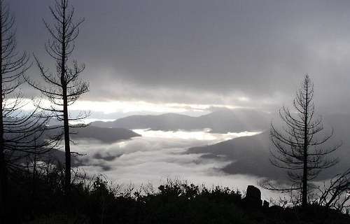
[img:130003:alignleft:small:]Weather conditions in this area are varied with the seasons. In the summer it can be unbearably hot with some days reaching temperatures over 100 F. Winter snows blanket the area and shut down access to most trailheads. Between winter and summer there are lots of variables with storms that can be severe and deadly. Be advised, that in wet years many locations in this area can receive over 100 inches of precipitation.You should check the weather forecast for both Brookings, Oregon, and Cave Junction, Oregon to determine how to prepare for your hike.
[img:346541:alignright:medium:]
In addition to the weather, take into consideration the very real and strong likelihood that the standing burned snags will be falling across the trails during high wind events.
Books
Vulcan LakePreview: Talk about contrasts. The tan, weathered, buff-orange bedrock in which beautiful Vulcan Lake nestles, with Vulcan Peak rising abruptly overhead, contains such a high percentage of serpentinite rock that the area is a virtual desert. The few trees and shrubs are stunted and bizarre. And yet, from the trail summit above the lake, one can see the Pacific Ocean and the lush vegetation of the coastal mountains. Of the many alpine glacial lakes in southern Oregon and northern California, this is the only one reached from the coast. Highlight: A beautiful little alpine lake in the Kalmiopsis Wilderness within view of the ocean. Botanical interest.
From the guidebook Hiking Oregon's Southern Cascades and Siskiyous
Brookings, OR - Hiking - 3 miles
Mislatnah Peak
Preview: Some places do not lend themselves to trails. A path up the side of the Empire State Building, for example, would be impractical. The same is true of the 3,000-acre Big Craggies Botanical Area, on the northwest edge of the Kalmiopsis Wilderness. These formidable outcrops, resembling stoneware platters stacked on end, comprise the visual focus of the entire region. Big Craggie, 4,600 feet high, soars 4,000 feet above the Chetco River. Several extremely rare plants grow in the scattered patches of thin soil between the cliffs of the Big Craggies. Its peridotite rock is similar to serpentinite and supports similar flora. The Big Craggies Botanical Area was created to protect those plants and the lack of trails has the same objective. The most sensitive plants include Brewer spruce, Kalmiopsis, Cascade sedge, Siskiyou fritillaria, and Howell’s manzanita. The Mislatnah Trail (pronounced “mis-LAY-tna”), offers the closest views of the Big Craggies and is the only route to penetrate even a corner of the Botanical Area. Highlight: An enchanted hike down to and up from the Chetco River to a wilderness mountain summit. The only entry into the beautiful Big Craggies Botanical Area.
From the guidebook Hiking Oregon's Southern Cascades and Siskiyous
Brookings, OR - Hiking - 9 miles
Kalmiopsis Loop (Backpacking)
Preview: This classic loop hike is the ideal way to explore the crumpled ridges and steep canyons of southwestern Oregon’s little-known Kalmiopsis Wilderness. Backpackers interested in botany will especially enjoy this trip because the Klamath Mountains support the greatest diversity of rare and unusual plants in Oregon. Keep an eye out for such species as mountain azalea, Brewer’s “weeping” spruce, Port Orford cedar, knobcone pine, pitcher plant, and, of course, Kalmiopsis leachiana—for which the wilderness was named. The route is strenuous and involves a ford of the Chetco River that, early in the year, can be difficult or even impossible. Call ahead to the Illinois Valley Ranger Station in Cave Junction for the latest conditions.
From the guidebook Backpacking Oregon
Grants Pass, OR - Hiking - 54 miles
Tourist and Other Links
[img:311169:alignright:medium:]Brookings, OregonCave Junction, Oregon
Oregon Caves National Monument
Grants Pass, Oregon
Gold Beach, Oregon
Rogue River Jet Boats
Redwoods National Park