MONT BLANC/JORASSES/VERTE and 33 MOUNTAIN CHAINS of the AOSTA VALLEY & SURROUNDINGS AOSTA VALLEY 360° from
West to East and from East to West in TOPOGRAPHIC clockwise system and order from
Seigne Pass towards Seigne Pass
(PARTS A+B+C+D+E+F+G). SECOND PART (B): PART B)- AOSTA VALLEY
PARTIAL HALF CIRCULAR NORTHERN PERIMETER (40°~) OUTSIDE AREA.
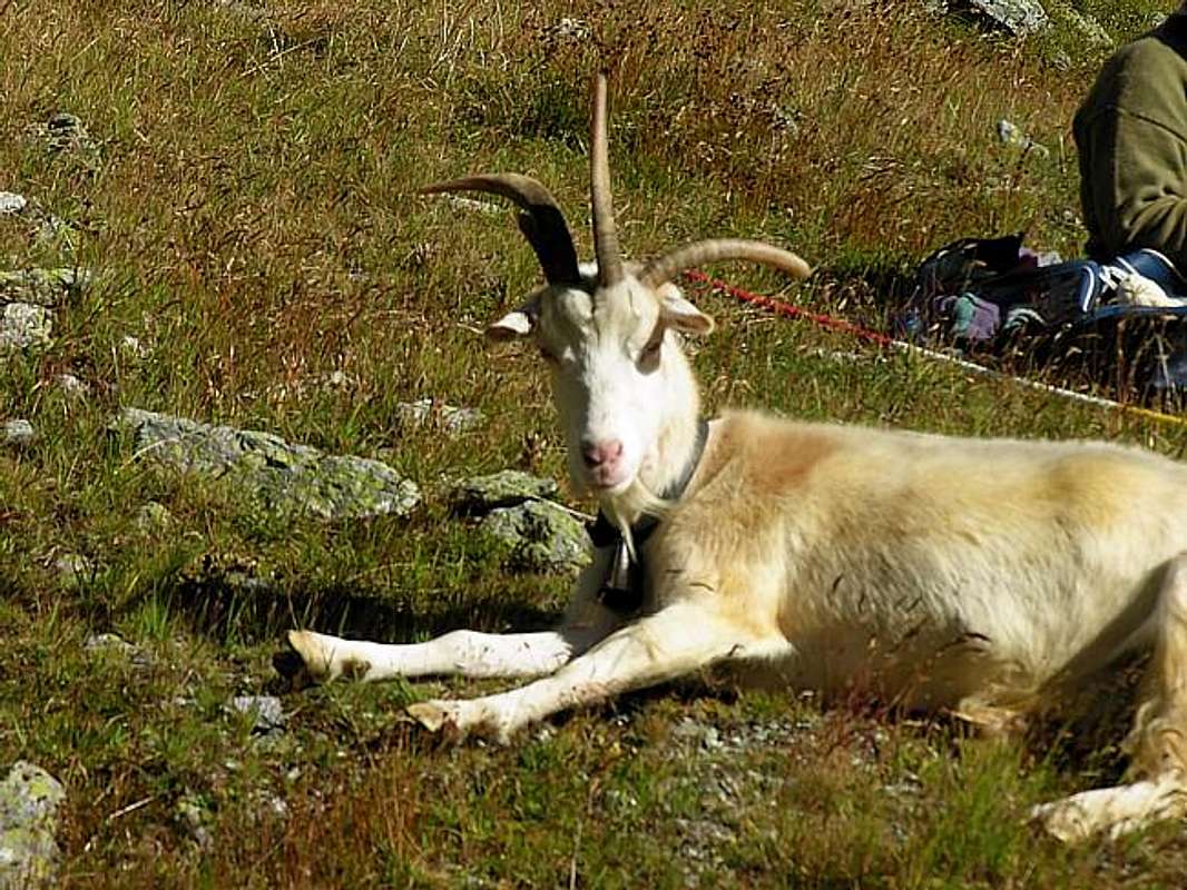
*** An old passion for the inhabitants of the Community of Grand Combin: are held every year in September "Les Batailles des Tzèvres", by Antonio ![]() ^^^^^^^LEGENDA
^^^^^^^LEGENDA In
red: paths, routes, cable railway, chair lift & main roads; in
green: Summits, Spurs, Buttress, Spires; in
blue: Glaciers, Lochs, Ponds, Streams, Torrents, Brooks & Fountains; in
purple: Passes, Saddles, Hills, Brèches, Carvings & Collars; in
brown: Historical Remarks, Sanctuaries, Hermitages, Oratories, Castles, Churchs, Chapels, Crosses, Cairns, Tumulus, Mines, Historic Bridges or Roads, Campings, meaning of place names & various informations.
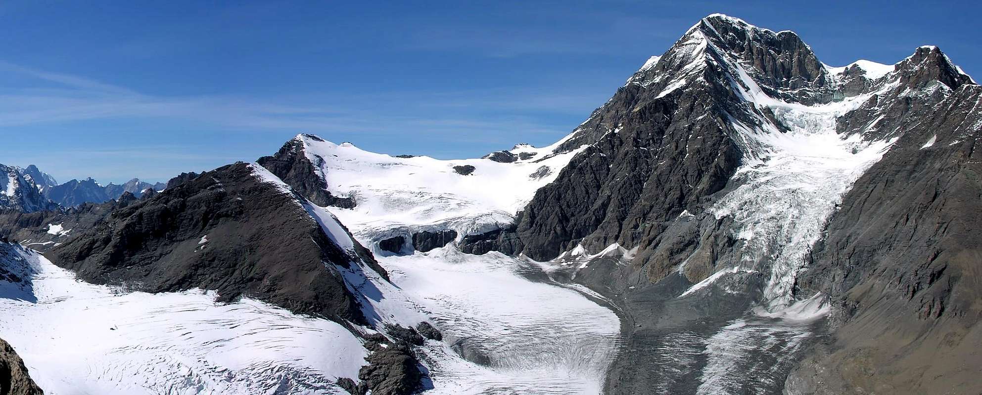
WESTERN PENNINE ALPS
After the Col Grand Ferret
( 2490m ) terminate the Graian with the imposing Mont Blanc Mountain Chain, from this starting point that the Pennine Alps, through trend first in the East and then to the East -northeast, unfold on the crest of border between Italy and Switzerland until the chain of Mount Rosa and beyond. We decided, for convenience of description, to divide them into three parts:
a)-: Western Pennine Alps, ranging from the Col Ferret to Col d' Ayatse also of O(A)yace Pass
(3061m), just after the Mount Gelé.
b)-: Central Pennine Alps from the hill above the Col Eastern Tiefenmatten, preceding the Dent d' Hérens.
c )-: Pennine Alps Eastern stretching Eastward that this important pyramid in the direction of the Matterhorn, the Breithorns, Lyskamms and the Mount Rosa Chain to the Tops Zumstein and Gnifetti, since the higher, or the Point Dufour, is completely on the border between Piedmont and Switzerland and therefore no longer in Aosta Valley. In the case of the West Pennine Alps there is to be noted that the dividing crest, after having raised the imposing Great Golliaz
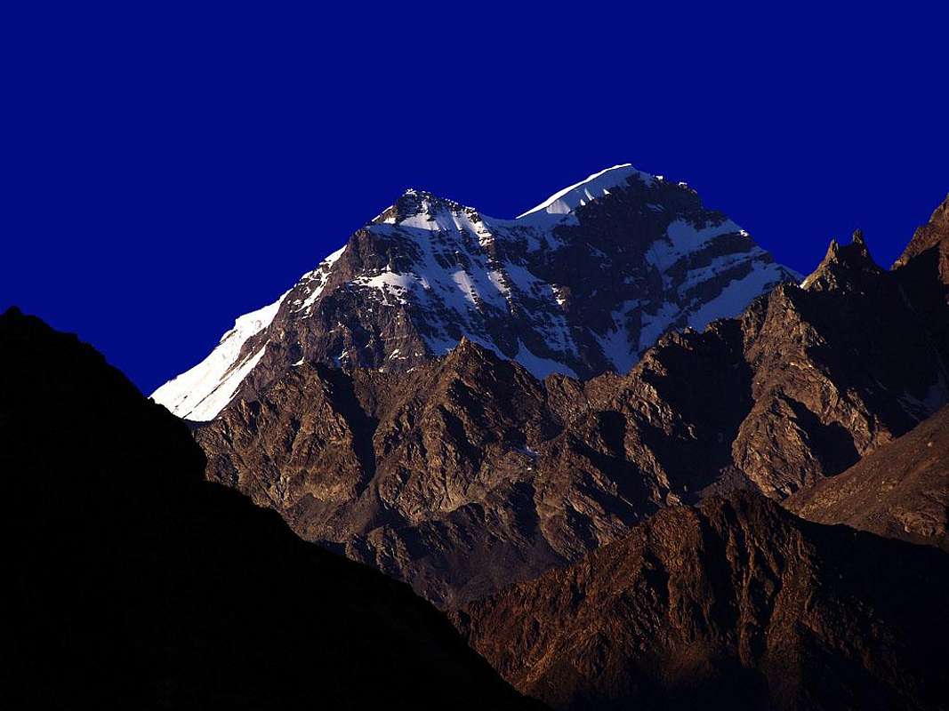
(3237m), reaches its peak in the mass of Mount Velan
(3734m) completely covered by ice in the North and almost free to the South-southeast; remains even a small glacier on the Southwestern slope above the Walloons of Molline and Menouve. As for the Pointe Doufour, even the Chain Combins does not belong to the Valley of Aosta, indeed, in this case, is to detect as it is completely in Swiss territory. After the ridge slopes down to the Valsorey Pass, the Tre Fratelli (Three Brothers), the Molars and other lesser-known Peaks to Mount Avril over the Fenêtre Durand
(2797m), crossing certainly more known and popular for its ease of passage, this long stretch of chain range. After the hill, the crest rises again towards the majestic Summit of Mount Gelé and down to the South eponymous hill and continue the important Ridge of the Morion, between the Basin By-Ollomont and that of Crète Sèche- Ciardonney. From the Hill of Mount Gelé, more precisely from the Mount of the Balme
(3347m), down a short Southeast Crest to Ayatse Pass, where he began the Range of the Pennine Alps Central. These form a series of peaks on average between
3200/3500 meters, the height of which is in the last elevation in the East, or the Tete of Valpelline
(3796m) and ends in both West and East Hills Tiefenmatten, before the pyramid of the Dent of the Hérens
(4175m). In his development of the dorsal raises a number of summits poorly understood, more or less busy but certainly fascinating and looking really wild. In succession from West to East we have: Ciardonney Becca, Rayette, Grand- Pecon or Epicoun, Aouille Tseucca, Grand- Blantsin or Blanchen, The Sengla, Peaks Orein, the important Collon Pass
(3080m) and Mount Braoulé, with a short detour to the North, Dents of Bouquetins, from this ridge, with large semi-circular around to the East and then Southeast, reaches the Valpelline Pass
(3559m) and the Head of the same name.
Dopo il Colle di Grand Ferret (2490 m) terminano le Alpi Graie con l'imponente Catena del Monte Bianco; da questo punto iniziano le Alpi Pennine che, tramite andamento dapprima ad Oriente ed in seguito a Est-nordest, si dispiegano sulla cresta di frontiera tra Italia e Svizzera fino alla Catena del Monte Rosa ed oltre. Abbiamo deciso, per comodità di descrizione, di dividerle in tre parti: a)-: Alpi Pennine Occidentali, che vanno dal Col Ferret al Col d'Ayatse oppure d'O(A)yace (3061 m), subito dopo il Mont Gelé. b)-: Alpi Pennine Centrali dal colle suddetto al Colle Orientale di Tiefenmatten, precedente la Dent d'Hérens. c)-: Alpi Pennine Orientali allungantesi da questa importante piramide in direzione del Cervino, i Breithorns, Lyskamms e la Catena del Monte Rosa verso le Punte Zumstein e Gnifetti, poiché la più elevata, ovvero la Punta Dufour, trovasi completamente sul confine tra Piemonte e Svizzera e quindi non più in Val d'Aosta. Nel caso delle Alpi Pennine Occidentali v'é da rilevare come la cresta divisoria, dopo essersi rialzata all'imponente Gran Golliaz (3237 m), tocca il suo vertice nella massa del Mont Velan (3734 m) completamente ricoperta dai ghiacci a Nord e quasi del tutto spoglia verso Sud-sudest; rimane ancora un piccolo ghiacciaio sul versante Sudovest sopra i Valloni di Molline e Menouve. Come per la Punta Doufour, anche la catena dei Combins non appartiene alla Valle di Aosta, anzi, in questo caso, é da rilevarsi com'essa sia completamente in territorio elvetico. Più in là la cresta digrada verso il Colle di Valsorey, i Tre Fratelli, i Molari ed altre Vette meno conosciute fino al Monte Avril sopra la Fenêtre Durand (2797 m), valico sicuramente più conosciuto e frequentato, anche per la facilità di passaggio, in questo lungo tratto della catena montuosa. Dopo il colle, la cresta si alza nuovamente maestosa verso la Vetta del Mont Gelé per poi scendere verso Mezzogiorno all'omonimo colle e proseguire con l'importante cresta dei Morion, tra la Conca di By-Ollomont e quella di Crète Sèche-Ciardonney. Dal Colle del Mont Gelé, più precisamente dal Mont de la Balme (3347 m), scende una Crestina Sudest al Col d'Ayatse, ove inizia la Catena delle Alpi Pennine Centrali. Queste forman tutta una serie di Vette mediamente tra i 3200/3500 metri, l'apice delle quali si trova nell'ultima elevazione ad Oriente, ovvero la Tete de Valpelline (3796 m) e termina nei due Colli Ovest ed Est di Tiefenmatten, prima della piramide della Dent d'Hérens (4175 m). In questo suo svilupparsi la dorsale eleva una serie di cime poco conosciute, più o meno frequentate ma sicuramente affascinanti e dall'aspetto veramente selvaggio. In successione da Ovest verso Est avremo: Becca Ciardonney, Becca Rayette, Grand-Pecon o Epicoun, Aouille Tseucca, Grand-Blantsin o Blanchen, La Sengla, Cime d'Orein, l'importante Col Collon (3080 m), Mont Braoulé e, con breve deviazione a Settentrione, Dents des Bouquetins; da questa la cresta, con largo giro semi circolare in Est e poi Sudest, raggiunge il Colle di Valpelline (3559 m) e l'omonima Testa.
Getting There
By car:
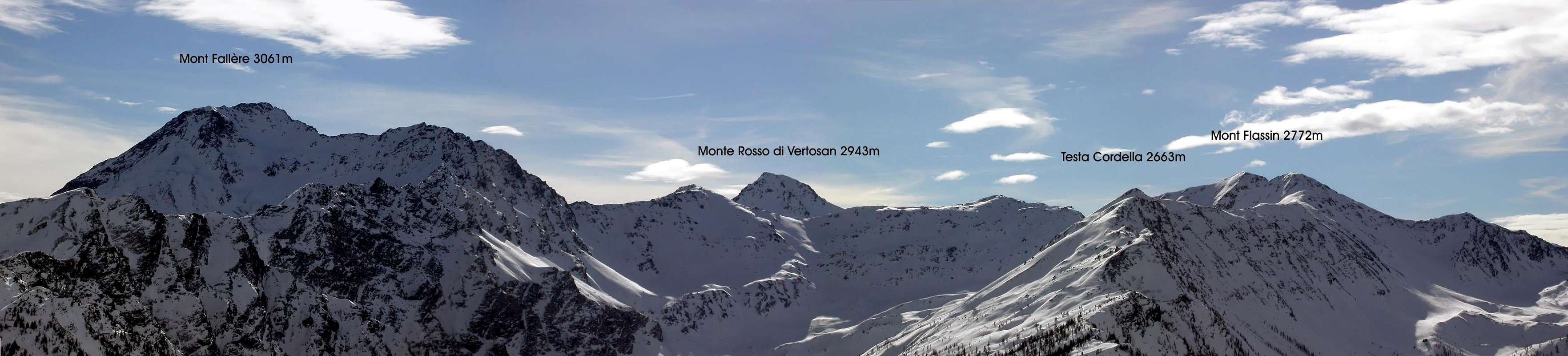
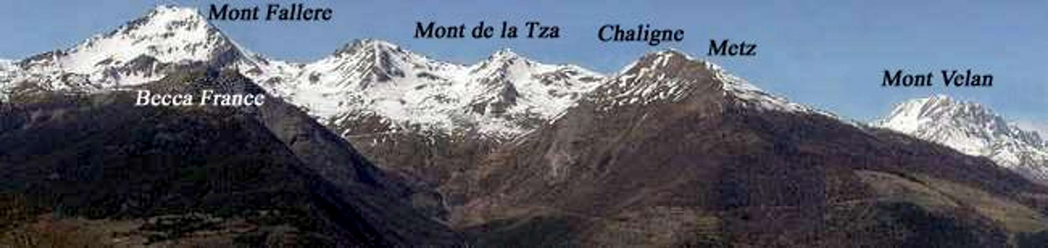
- From TORINO, MILANO Cities, etc: Motorway A5. Exit at AOSTA Est: (Valpelline, Ollomont, Great Saint Bernard Valleys and Merdeux Comba, near Malatrà Pass); AOSTA West/Aymavilles to Saint Pierre-La Salle little towns: (Vertosan Valleys to Citrin Pass; Vétan Tourist Village/Mount Fallère Area to Finestra Pass or Chiusella little Valley to Fallère Lake and Saddle 2674m, Chaligne and Met Pass); Morgex: (Valdigne or Courmayeur to Ferret Valley and Great Ferret Pass; Courmayeur-Villair-La Trappe in little Sapin Valley to Sapin Pass. Morge-Planaval/Great Rochère Area) to Liconi, Battaglione Aosta, Serena Pass.
- From SWITZERLAND: through the Saint Bernard Tunnel or the Great Saint Bernard Pass, closed since late Autumn until half Springtime, to Saint Rhémy en Bosses-Saint Oyen-Etroubles-Gignod-AOSTA Towns.
- From FRANCE: through the Mont Blanc Tunnel to Entrèves-crossroads to Vény/Ferret Valleys- Mountain Guides of Courmayeur-La Saxe Rock Gym-Courmayeur. By Little Saint Bernard Pass, closed since November until half May to La Thuile Valley-Pré Saint Didier-Courmayeur. It is not necessary to take Motorway A5: you can drive on SS.26, in the direction of AOSTA-IVREA-TURIN.
By plane:
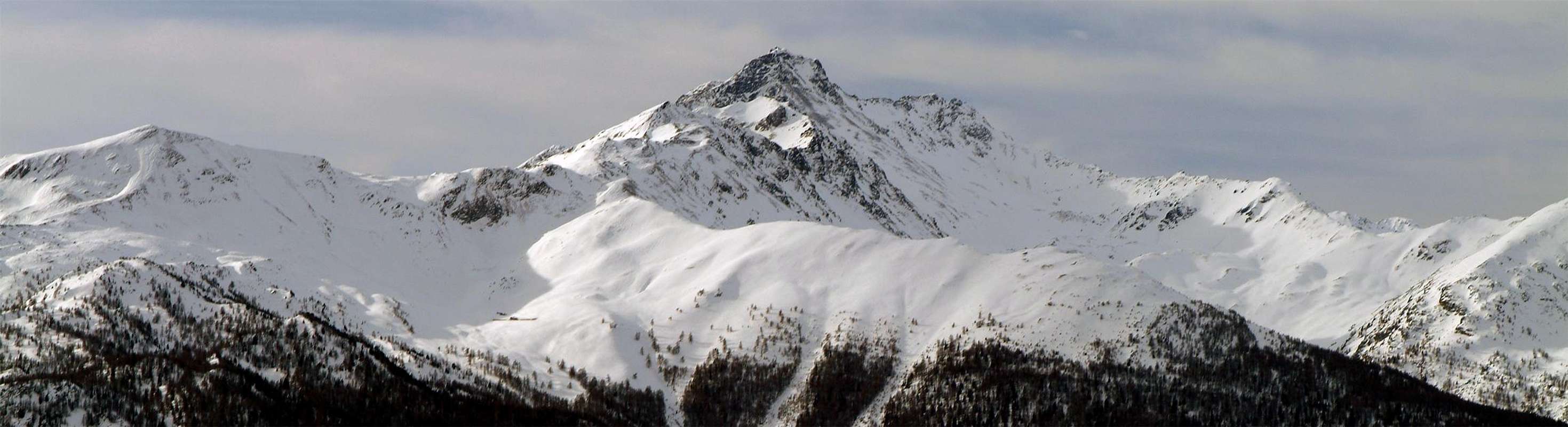
The MOUNT VELAN SKY (3734m)
B1)- *** ALL EXTERNAL PASS, saddles, brèches, "carvings" & ROUTES from AOSTA VALLEY to SWITZERLAND
B1)- *** ALL EXTERNAL PASS, saddles, brèches, "carvings" and ROUTES from AOSTA VALLEY to SWITZERLAND. From West to East-northeast BETWEEN ITALY and SWITZERLAND from: Great Ferret Pass to Ban Darrey, Angroniettes, Fourchon, Ferret Finestra, Great Saint Bernard, Morts, Eastern Barasson, Southwest and Northeast Menouve, Molline, Hannibal, Valsorey, Amiante, By, Filon, Durand, de la Balme, Ayatse, Crete Sèche, Chardoney, Rayette, Epicoun, de la Aouille Tseucca, Otemma, Boetta, West and East Blanchen, Oren West and East, Evêque, Collon, Tsa de Tsan, Mount Brulé or Braoulé, Great Arete, Bouquetins, Valpelline, Westiefmattenjoch, Ostiefmattenjoch. BETWEEN Italian and Swiss Ferret Valleys: *** From Arn(p)ouva Alp (1769m) also from Elena Refuge (2062m) to: a1)- GREAT FERRET PASS (2531m); a2)- BAN DARREY PASS (2696m). a1)- From
Arn(p)ouva Alp (1769m) in
Ferret Valley follow along the
main road (open only to the cars of the ones that have a booking) at
Elena Refuge and, along the path
---> n° 25, get the
Prè de Bar Pasture (2062m) and the
Rifugio Elena (views to Pré de Bar Glacier Mount Dolent, frontally). Along the path up to
Tramail (2264m) and at the following fork 2316m; from cross, by North direction and path
---> n° 25, TMB, easily, toward
GREAT FERRET PASS (2531m), end of
Mount Blanc Mountain Chain, between
Little Ferret Pass/
Econduits Crest-Combette Point. In descent, through Northeast direction, path
---> n° 25, TMB, between
Les Planfins/la Chaudière in quota 2500m~. to
La Peule Alp (2072m) in
La Peule Tableland (below
La Dotse Mount), bridge 1774m up
Ferret Dranc(s)e Stream Ferret Tourist little Town (1705m) in swiss
Ferret Valley. For HikExp, (EE). a2)- From
Arnouva, by preceding route to
Elena Refuge and to cross 2343m, up a small rocky strip, and to quota 2420m~, end of path. Through traces in moraine towards a small narrowing, 125m~, below the pass; by rubbles and friable traces to
Ban Darrey (2696m), between
Combette Point/Aiguilles des Angroniettes. In descent, through East-northeast direction, moraines, snowfiels not much steep to
Mount Percé Tsa (2164m), between
La Tenade/Plan Vés. From pasture, by path, between the moraine (
Taves du Mont Percé) and
Ferret Dranc(s)e Torrent in
The Ban Darrey, pastures to
Mount Percé Alp (2023m), below the three
Fenetre Lakes, in East-southeast (2456, 2512, 2499m). From alp, by Northwest direction, path, to bridge 1996m , upon the junction among
Ferret Drance, Penaux and various others little torrents, to
main route, between
Plan de la Chaux/Les Ars Dessus Alps (2041, 1955m) in quota 2015m~; through road to
Les Ars Dessous Alps (1802m),
Ferret. For HikExp, (EE). BETWEEN Great Saint Bernard Valley (Italy) and
Entremont Valley (Switzerland): *** From Prà(z) di Farcoz Pasture (2223m) to: b1)- ANGRONIETTES PASS (2936m); b2)- SADDLE 2835m~ also LEISACHE PASS; b3)- FOURCHON PASS(2696m). From Montagna Baou or Baous; (2356m) to: b4)- FERRET FINESTRA/FENETRE PASS (2698m); b5)- COL de FONTEINTE or FENETRE d'en HAUT PASS (2724m); b5bis, ter)- Of DEPARTURE VARIANTS from GREAT SAINT BERNARD PASS (2469m). b1)- From
SS. n° 27 Great Saint Bernard, in winding road 2079m, by North-northwest direction, to
Prà(z) di Farcoz Pasture (2223m;
* variant from crossroads 2105m, by groundroad); from alp, before through West direction, to hairpin bend 2357m, after South-southwest to
Saint Rhémy Pass (2540m). From pass, by West-northwest direction, brief descent in
Thoula(es) Combe and path along and 50 metres up
Thoules Torrent toward> the
sources, in quota 2680/90m~; continue, by Southwest direction, snowfields and path to
Saulié or Ceingles Pass, in quota 2730m~. Turn right (Northwest) and, by very steep moraine (truly fatiguing), go up on glacial cirque of
Bosses Glacier, in quota 2890/900m~; again, turn right (North) and, through a snowy moderate slope, broken rocks and rubbles in terminal part, easily, to
Angroniettes Pass (2936m), between
Great Golliaz(t)/Sasses or Leisache also Leisasse Aiguilles. In descent, by North direction, a brief snowy slope, debris rocks, a second snowy and steep slope (38°/35°) in North-northeast, to
Angroniettes Glacier, in quota 2660m~; to cross, by Northeast direction, towards moraines, between quota 2489/2399m and two
Tenades Torrent, to the
Drance Stream and path, in quota 2145m, joing previous route
a2)-. For M (EE/A). b2)- From
Prà de Farcoz Pasture
(see as above), by West direction, path
---> n° 12 to quota 2300m~, near the junction of two
Western Fourchon Torrents; by traces in pasture, between
Western and Eastern Torrent to four ancient
Tsa d'Arc Alps (2357m;
ruines). Continue, by West-northwest direction in debris tableland and by snowfields (30°) at steep and narrow gully; cross from right to left (30°/40°; delicate) and reach higher snowy slopes, in quota 2830m~; turn right (North) and through snowy and moderate slope to small basin, below
Leisache or Sasses Aiguille East-southeast Face. Go up easily, by snowfields and rubbles in terminal part, to
Saddle 2835m~ also Leisache Pass, between
Leisache Aiguille/Quota 2880m. In descent, by a snowy couloir (even 40°) among balconies and sheer rock faces (II°+/III°-; 180/90m; delicate;
falls rocks danger), to
Angroniettes Glacier, in quota 2750m~ and, by North direction, to
Mount Percé Tsa (2164m) and previous routes.
In ascent for M (EE/A); in descent for Hunters Exp.GREAT SAINT BERNARD TOUR Double Traverse from Great Saint Bernard Pass to GRANDE CHENALETTE, DRONE, TETES de FONTEINTE, POINTE de la FENETRE, MONT FOURCHON, PAIN de SUCRE, on JUNE 30th, 1996 and in Several Times
b3)- From
Prà(see as above) de Farcoz Pasture , by West direction, path
---> n° 12 to quota 2300m~, near the junction of two
Western Fourchon Torrents; by traces in pasture, between
Western and Eastern Torrent toward four ancient
Tsa d'Arc Alps (2357m;
ruines). Continue, by Northwest direction through grassy in debris tableland, along
torrent source (2510m~); double right (East) the South-southeast Spur of
Quota 2833m and, by a steep and boring debris, also snowy couloir (200m), to
Fourchon Pass (2696m), between
Quota 2833m /Mount Fourchon. In descent, by North direction, a snowy and debris couloir (35°/30°), moraines to narrowing 2318m. Go down, by rubbles flaw, to
Tenade little "Baita" (2164m), between
La Tenade/Plan Vés to
Mount Percé Tsa and preceding routes.
For M (EE/A). b4)- From
SS n° 27 of Great Saint Bernard, winding road 2356m (car parking, near
Montagna Baou or Baous; 2356m), by West direction, path
---> n° 13A, to
Fenêtre Torrent, in quota 2390m~; to cross, by typical white "escalier"
(stoneflight of steps). Go up to crossroads 2515m~, near the
torrent. To traverse and, by Northwest direction, go up in small valley, along Eastern
torrent ramification, to a small basin, below the pass. By progressive steep slope (sometimes in snowfields; 28°/30°) to
Ferret Finestra/Fenetre Pass (2698m;
rustic stoneshelter). From pass, by North direction, path
---> n° 13A also snowfields, in left diagonal between moraine in initial part, to
affluent-torrent of
Eastern also Upper Fenetre Lakes (2512m); to cross amongst the same and
Western and Northern or Lower Lakes (2499, 2456m) in
La Chaux Basin, below the
Bastillons Buttress to East. Go down, by West-northwest direction, across the
Retours toward
Plan de la Chaux Alp (2041m),
Les Ars Dessus Pastures (1955m) and preceding routes
a1)-/a2)- For Hik. (E). b5)- From
Montagna Baou (2373m, near parking 2356m), by North direction, path unnumbered, along small
torrent, in small basin toward alternative in quota 2406, 2481m, 2531m, below the of
Drone Point SW Face; by North-northwest direction, path progressive steep in the last 200 metres (easy debris couloir or, more in West, grassy slopes) to
Col de Fonteinte or Fenetre d'en Haut Pass (2724m), between
Fonteinte Head, South Point/Drone Point. In descent by North-northwest direction, better path, unnumbered, in morainic small vallon, below the
Fonteinte Head, North Point (West) and
Bastillons Buttress in East, to
Eastern also Upper Fenetre Lochs, East shore (2512m). From
lake, to North or
Lower Lake and preceding route.
For Hik. (E) b5bis, ter)-
VARIATIONS: a)- From
SS n° 27 of Great Saint Bernard, 300 meters after parking 2356m and 50 metres before a tunnel,
link-path--->.
b)- From
Roman Mansio/Jupiter Tableland; +; in quota 2460m, near
Italy Hotel,
Great Saint Bernard Lake (2449m),
Great Saint Bernard Pass (2469m), by Northwest direction, unnumbered
connection-path--->, below
Little Chenalette to fork 2531m and previous route.
For Hikers (E).
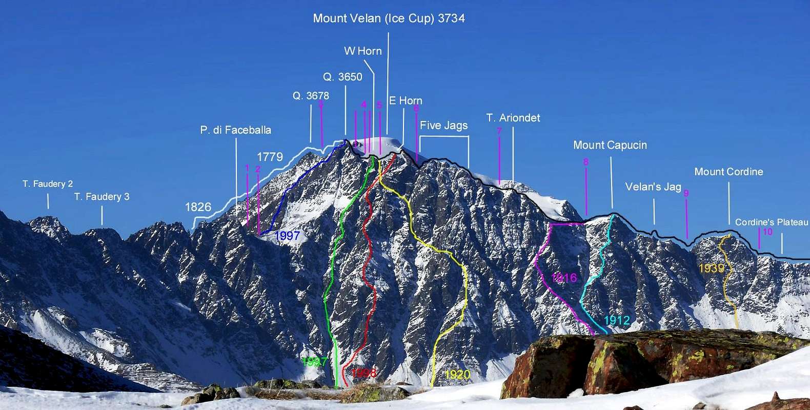
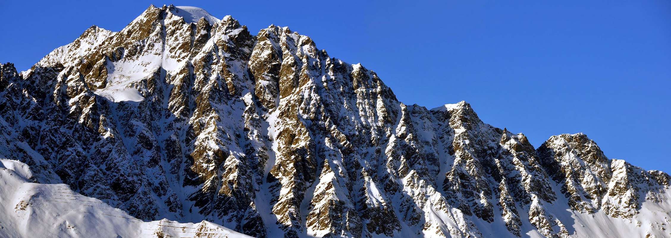
MOUNT VELAN S-SW Molline/Menouve FACE ![]()
*** From
Saint Rhémy Village (1621m) b6)- to GREAT SAINT BERNARD Pass (2469m); b6bis)- , b6ter)- EASTERN VARIANTS with NAPOLEONIC Route; b7)- Western BARASSON PASS (2635m); b6)- From
SS n° 27 of Great Saint Bernard (transit possibility, by cars, since end of May/Juny until late Autumn), near
Saint Rhémy Village (1621m;
+; Hotel Suisse; parking;
fountain) continue through 550m~ along
SS. 27 to road winter obstruction; by road, between
Thoules/Dzellette Alps to winding road 1730m (parking); to cross, by bridge, the
Great Saint Bernard Torrent and along to
La Tuette, Lower Praz Dzentor Alps (1876m), below the of tunnel underground entrance. By Northwest direction, continue in small ascent toward
Plan d'Arc, Praz d'Arc Pastures (1956m), near
Farcoz Torrent; go up, by path
---> n° 12, to hirpin winding 2079m, below
Praz de Farcoz (crossroads 2105m) and, by East-northeast direction,
SS. 27 to
Fonteinte Alp (2203m;
+; The Aosta Wineshop. Again, by road or path
---> 13, TdC, TAM, VA, more in East, to
GREAT SAINT BERNARD Pass (2469m;
Ancient, famous and renowned Canons Home Hospice).
For MExp., by ski or snowshoes. Since at beginnig of April until half May.
*** TO AVOID ABSOLUTELY the ascent after snowfall; To DISCARD the routes, in East, 13, 13B, below
Tchoume Head/Barasson Coastline/Barasson Head/Mount Mort,
very avalanches exposed!.
In descent from
GREAT SAINT BERNARD Pass , through
Swiss SS. B21 or parallel path
---> n° TdC, VA in
Morts Combe to
Le Tronchet (2270m) (junction
Barasson Torrent/Dranc(s)e Stream; path to
Dead Comba),
Plan des Dames,
Nudry Bridge up
Entremont Drance Stream in
Martchanda Comba, L'Hospital, Maringo, Bourg Saint Bernard (1927m),
Bourg Saint Pierre (1632m),
Liddes (1346m),
Rive Haute (1223m),
Fontaine Dessous, Orsières (879m) in junction
Ferret/Entremont Valleys. Same remarks. Smugglers and Pilgrims Ancient Route; The Morgue, near Friars Hospice, in + South. Great Saint Bernard Dogs extant. Route for Good Skiers/mountaineers (BSA) or Excellent Connoisseurs of Snowshoes Technique. Good weather necessary.
b6bis)- Variant of fine weather. From
Saint Rhémy Village, near the Parking
SS n° 27 of Great Saint Bernard, by road or parallel path
---> n° 13B, TdC, TAM, VA, to obstrucion, between
Thoules/Dzellette Alps; from quota in road 1700m~, through North direction toward crossroads 1970m~, near
Novailloz Alp; continue, by Northwest direction (various paths) to forkroads 2210m, near
Tarédaz Pastures (1950m) and to join the higher path
---> n° 13, below Plan de Raye Spur, in quota 2125m. To go up, by North-northwest direction and unified paths
---> n° 13, 13B toward
Cantonal Home "La Cantine d'Aoste"/Fonteinte Alp (2203m); by North direction to cross the
SS 27, in quota 2265m~, and, by a terminal part more steep, between various small </font color=blue>torrents reach the quota 2352 m, below
SS. 27 and near an old alp (in West). Turn abrupt in right and, by East-southeast direction to
Lake (2449m) and
GREAT SAINT BERNARD Pass and previous route.
For Hikers. b6ter)-
High Eastern Variant. From road, quota 1700m~, by North direction to alternative 1970m~, near
Novailloz Alp (1970m); turn right, by East direction and path to
Novailloz Alp (1970m) and next fork 2050m (
Napoleonic route to
Plan Puitz(s) (2127m;
defences in tunnel underock), in South-southeast at the end of
Barasson Coastline). Turn in the shape of acute angle in left and, by Northwest direction, path
---> n° 13, to fork, in quota 2125m, below
Plan de Raye Spur and previous route.
For Hik. and Smugglers b7)- Through previous route, and from quota 2100m~ in
Napoleonic route and, by North direction, at
Mount Mort South Spur base, in quota 2354m; go up, by Northeast direction, small, rare traces and rubbles to
Western Barasson Pass (2635m), between
Mount Mort/Barasson Head (
two great power line up the crest; a pylon near the pass, in North).
In descent, through North direction, path in moraine to
small Lake 2589m and groundroad in hairpin winding 2490m, near the of
Barasson Torrent sources in
Barasson or Dead Comba; go down, by dirt farm road, along
West shore of torrent, toward
Le Tronchet rustic bridge
(stoneshelter 100m~ up small promontory, in East), near
Swiss SS. B21. From
Tronchet two possibilities: a)- descent to Orsières (see above route
b6); also:
b)-, by Southeast direction, path or road, to
Great Saint Bernard Pass and
Italy.
***VARIANT. From
groundroad in quota 2380m~ to traverse, by small traces in left, and to double
Mount Mort North-northeast Spur at base, in quota 2418m; to cross, by Southwest direction, small trace to quota 2397m, near little
torrent, quota 2438m, below
Mount Mort Northern Face. In terminal part, to turn right (Northwest) and, by a brief descent/ascent, to
Saint Bernard Pass.
For Hikers and Ancients Smugglers *** b8)- From Saint Oyen Village (1373m)
Eastern BARASSON PASS (2681m); b9)-
MENOUVE or MENOVY Southwestern PASS (2758m); b10)-
MENOUVE or MENOVY Northeastern PASS (2775m). b8)- From
Saint Oyen Village, by main road, to
agriturisme "La Grandze In Tsi Inconnu"; beforehand (200m~), turn left (West) to
Eternon(d) Village (1645m;
+;
fountain) to
no thoroughfares 1715m, between two alternative dirt farm roads. Always by groundroad, continue in West direction, between a series lower pastures/
(L)Essana(z) Alp (1820m), to a small wooden bridge up
Barasson Torrent, near
Barasson Pasture (1868m). From alp, by North-northwest direction, path
---> n° 16, 17, up the (or by lower traces along West side)
Barasson Torrent to
Crétoux or Cretou Pasture (2074m); 50 m in North; cross the
torrent and, by same direction, leaving East the path
---> n° 17 to
Paglietta Alp, go up at base
Barasson Point a secondary South-southwest Spur, in quota 2350m~. Turn left (North-northwest) toward a small debris basin, in quota 2500m~, and, always by path
---> n° 16, small rocks, easily to
Eastern Barasson Pass (2681m).
In descent, by North-northeast direction, rubbles, scattered traces, to
pond 2525/30m~. (from East second
source Barasson Torrent) swiss; go down to hairpin bend 2490m and previous route
b7)-. For Hikers and Ancient Smugglers b9)- From
Saint Oyen) Village to
Farm Holidays (see above
b8)- ).
* Also from
Etroubles Village (1264m;
+ Hotels;
fountains), in
SS. 27 and
Vachery Village (1332m;
+), by paths
---< n° 18, 19A. From Agriturisme, by dirt road, to
obstruction, in quota 1608m~, near
Quaye Alp ; continue, by North direction, dirt ground road, between
Menouve or Menovy Torrent/Menouve Ru to
Menouve Alp (1913m). By Northwest direction, path with left diagonal ascent, to
Trecaoudette Alp (2133m). From pasture, by lower dirtdroad to
Menouve Torrent, near
Menouve Tsa (2243m), in East, at the end of
Mount Menouve/Great Mol(l)ine Southern small Buttress. From hairpin bend 2315m, by Northwest direction, to
Tsa Nouva Pasture (2426m).
**Alternative route: by North-northwest direction, upper path
---> n° 21 from
Traca(o)udette Alp to
Tsa Nouva Alp. From pasture, by North direction, path along
central source of Menouve Torrent to alternative paths in quota 2645m~; turn left (West) and, by brief diagonal in terminal part, to
Menouve or Menovy South-western Pass (2758m).
In descent, by Northwest direction, rubbles, traces in moraine, between
Tete Rouges, North-nortwest Ridge (in left) and
Becs Noirs. North-nortwest Buttress towards upper
Barasson Torrent source, in quota 2500m~; along the
torrent, by before West, after Northwest direction, between
Tchole(a)ire Tableland/Les Places to quota 2360m and, by small path, quota 2331m,
SS. B21, near
The Hospitalet (2116m;
Parking;
little lake), in
Comba Martchanda and preceding routes.
For Hikers and Ancient Smugglers b10)- From
Saint Oyen Village, by main road, to
Agriturisme "La Grandze In Tsi Inconnu"; by previous routes towards
Tsa Nouva> Pasture, fork of paths in quota 2645m ; turn right (North-northeast) to
Menouve or Menovy Northeastern Pass (2775m;
cable railway Station in summit). In descent, by directly North direction, trace to barrack-ruine in quota 2407m, in
Menouve Valley, between
Becs Noirs North-northwest Buttress, in West, and
Mount Menouve or Les Rayons de la Madeleine Point/Crete Seche Point, in Northeast. Continue below and in East of cable at the entrance of tunnel and
main road, in quota 2175m; by road to
Sommet de Proz (1950m;
direct descent possible, by a rare traces in North),
Bourg St-Bernard (1927m) to
Orsières.
For Hik. and Ancient Smugglers.
*** From Etroubles-Quaye Alp (1550m~) b11)- Southwestern MOLLINE PASS (2915m); b12)- Northeastern MOLLINE Pass (2907m); b13)- HANNIBAL PASS (2992m); b14)- SADDLE 3640m~ with 5 descent VARIANTS; b15)- Double North SADDLE 3650/5m~ and b15bis)- VARIANT Double South Saddle 3647/50m~; b16)- BRECHE 3628/30m~ b11)- From
Etroubles-Quaye Alp (1550m~) by previous route
b9)- to
Menouve Alp (1913m); from pasture, by North direction, dirt road towards
Arvus Alp (1988m), in the entrance of
Mol(l)ine Walloon; go up, by North direction, an unnumbered and steep path in grassy slope towards a first little alp (ruins), in quota 2140m~, near the fork paths, with
---> n° 21, in small tableland. By path
21, turn 230m~ in right (East) and go up, along and in edge of pronounced right lateral moraine, to quota 2383m and the following
Molline Bivouac/Refuge (2415m;
in peak season with keeper), near
Moline Alp; from bivouac and alp, by North direction, unnumbered path to alternative paths 2519m, near the junction of two
Molline Torrents. By Northwest direction, both paths, to cross, along two
torrents, the debris
Molline Tableland to junction 2580m; continue, same direction and, by more and more steep traces of path in moraine or snowfields in terminal part (at the begin of season), to
Southwestern Molline Pass (2915m), between
Rayons de la Madeleine/Crete Seche Points. In descent, by West-northwest direction, a very steep debris scarp and broken rocks (passage traces) also snowfields (30°, even 35°) towards the base of a moraine in quota 2625m; to traverse towards barracks-ruins 2407m and, by previous route
b10)- to
Orsières. For Hik. Exp., Hunters and, in those were the days,
Ancient and Old Smugglers!. b12)- From
Etroubles-Quaye Alp (1550m~) to
Molline Bivouac/Refuge (2415m) and, by preceding route
b11)- to cross in North the entire
Molline Tableland and Walloon; continue as far as basin in quota 2750m~. (snowfields extant possibility), where the path turn in left to
Southwestern Molline Pass. Instead, climb directly in North direction and, through a progressive steep slope (155/60m; 28°/32°, in snowy slope) to
Northeastern Molline Pass (2907m), between
Crete Seche Points/Molline Points.
In descent, by North direction, brief steep morenic part (traces), long and tiring moraine toward a first narrowing in quota 2650m~. (
Les Fouereuses); after go down a second in quota 2490m~, near
Western Trois Torrents, and to junction
three torrents (Perche Torrent) at base of
Crete Seche Point North Spur, in quota 2250m~. Turn in North 220m~ to unnumbered path, below
cable station (2273m) and descend, by West direction, along and below the plant (
Les Darreys), to
Plan du Jeu Alp (2074m); through main road in final part, toward
Bourg St-Bernard (1927m) path
---> Orsières or path
---> Great Saint Bernard Pass (2469m)
. For Hik.Exp., Hunters and Old Smugglers. b13)- From
Etroubles-Quaye Alp, previous preceding routes
11)-, b12)-, towards, in North, the entire
Molline Tableland and
Walloon up to paths junction in quota 2600m~; leaving left (Northwest) the routes, go up, by North-northeast direction, traces among great boulders, hard sandstones and moraine at base of
Mount Tunnel South-southeast small Spur, in quota 2678m, near a narrowing. Continue, through same direction and trace, to splitting path in quota 2800m~ (in left to
Mount Tunnel/Tete Grise) and climb right (Northeast), by a steep moraine, blocks, or snowfields in off season, also in end of (30°; with a lot of snow, even 35°) to
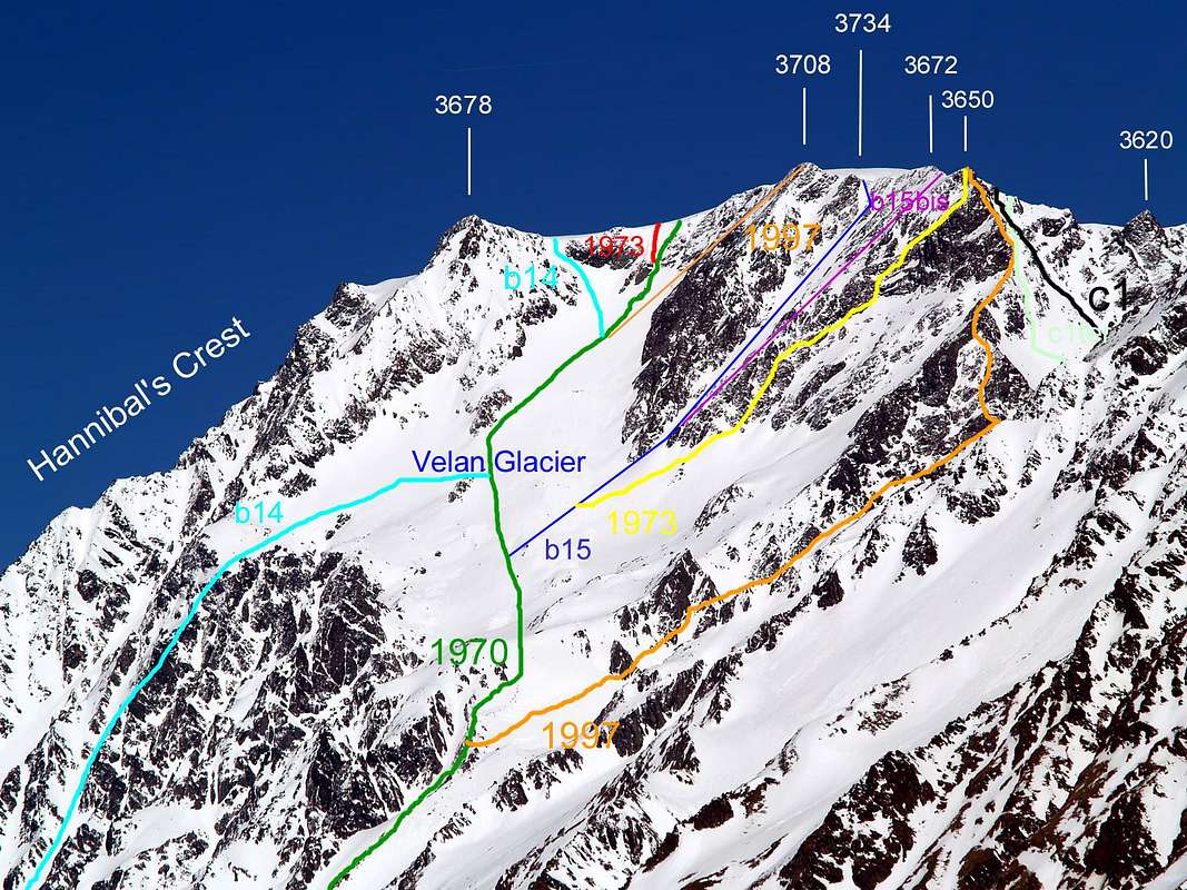
Hannibal Pass(2992m; splendid views frontally to
Mount Velan West Ridge (Hannibal Crest) and to magnificent West Face).
In descent, by North direction, moderate snowy slopes (20°/25°) to
pond 2956m; to cross, same direction the
Proz Glacier to three principal
glacier sources of Perche Torrent, in quota 2820/2795m~, at base of
Grey Head Northern small Spur, in quota 2816m. Go down, by West direction, moraines and scattered traces, along North side of
Perche Torrent toward the Cable Station (2273m) and previous route
b12)-. For MExp. (EE/A) and for Hannibal and
Napoleon landing force. In more ancient times for Salassian Celtic People of Aosta Valley inhabitant and Swiss Valais People perennially amongst trade exchanges, feasts and battles.
b14)- From
Etroubles-Quaye Alp, previous routes
b11)-, b12)-, towards
Molline Bivouac/Refuge (2415m); from refuge, by Northeast direction, brief descent, crossing the
Menouve Torrent, in quota 2400m~
to left lateral moraine of
Mount Velan Glacier, in quota 2440m~; go up in edge, by East-northeast direction, traces and steep grassy slope, very slippery for "erba Ollina" presence (
"Ollina" grassy, in valdotain language). Reach the small
Faceballa Basin in quota 2900m~, below
Faceballa Saddle/Faceballa Pass. Cross in Northeast direction two broken and rotten rocky ramification, descending from
Quota 3650m. Continue, by same direction, reaching the
Mount Velan Glacier, in quota 3120/30m~. Cross, through moderate and progressive slopes (30°/35°/40°),
toward higher northeast border and at the
Mount Velan West Ridge
(Hannibal Crest) base, in quota 3600m, below the
Quota 3678m; climb, before by steep snowy-rocky balcony in diagonal right/left, after snowy in vertical (38°/40°) to West Ridge and, briefly, small
Saddle 3640m~, between
Quota 3678m / Mount Velan Ice Cup (3734m). By East direction, easy snowy slope (25°), briefly in the
Summit.
Route for Good Skiers/Mountaineers (OSA) or Excellent Mountaineers, much training. Good weather absolutely necessary.
In descent five possibilities (a, b, c, d, e): a)- descent by same route toward
Molline/Menouve Valleys.
Same remarks and considerations. b)- to cross in South, through
ice Cup, to
Quota 3708m, large
Saddle 3650/5m~ and go down by
b15)- to
Molline/Menouve Vallons.
For adventurous (or adventurer?) Mountaineers also a bit joker. c)- from
Quota 3708m cross to
Quotas 3672, 3650m, narrow
Brèche 3628/30m~ and route
c1)- toward:
1)- Molline/Menouve Walloons also
2)- By Conca through
Faceballa Saddle (3280m).
For M very Exp. a good deal of training. d)- from
Quota 3708m to
Quota 3672, 3650m cross, through
Mount Velan entire Northeast Ridge, or below the crest in North, to
Valsorey Pass and
By Conca. For M very Exp. a good deal of training. e)- to, through
Valsorey Glacier to
Velan Hutte, by route
c7)-. For Mountaineers/Skiers Exp. a lot of training. b15)- From
Etroubles-Quaye Alp, previous preceding routes
b11)-, b12)-, b14)- to
Mount Velan Glacier, in quota 3120/30m~; go up, by Northeast direction and moderate snowy slope (30°/35°), at the
Double North Saddle 3650/5m~ couloir base, between
Quotas 3708m / Quota 3672m, in quota 3365m~. Climb, by narrow and very dangerous snowy, or end of season rocky, gully easily (38°/42°: II°/II°+, some passages III°-
at basis; 285/90m~), but keeping always the head to sky!
(rocks falls along the entire ascent or descent. On September 06th,
1973, during the descent, great landslide for collapse a pillar 70/80 metres high.
Old route among the years 1872/1902, at present justly deserted.
For Mountaineers, as well Expert, but to look for trouble! b15bis)- VARIANT 1. At the beginning of couloir to climb, by rocky right diagonal in W-SW Face,
to Quota 3672m and, through easy brief N Crest, to cross to the
Double South Saddle 3647/50m~.
Same remarks and observations. b16)- From
Etroubles-Quaye Alp, previous preceding routes
b11)-, b12)-, b14, reach the small
Faceballa Basin in quota 2900m~, below
Faceballa Saddle/Faceballa Pass (3280m, 3239m); go up, by East-northeast direction, debris, rubbles, moraine, small rocks and snowfields in terminal part to quota 3076m, below the pass. Climb, by easy rocks on couloir (
rocks fallings motive dangerous), also in left (North), by broken and rotten rocks slope, under Southwest Crest of
Quota 3650m. By route
c1/2)- to
Saddle 3628/30m~, facing South and turned to
Berruard Comba/By Conca. For MExp. and a good training. In descent: to
Valsorey Glacier and various possibilities
see c1)- and, in particular,
c1bis)-. To
Faceballa Saddle (3280m)
for Mountaineers (EE/A) and Expert Hunters; entire crossing for M Exp and, in day entire route, a good training.
BETWEEN Doues "Conca" / Ollomont Valley and
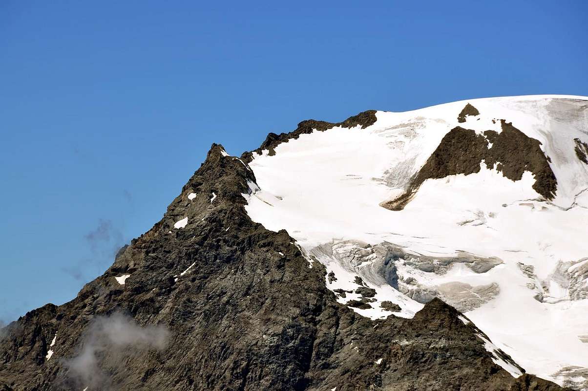
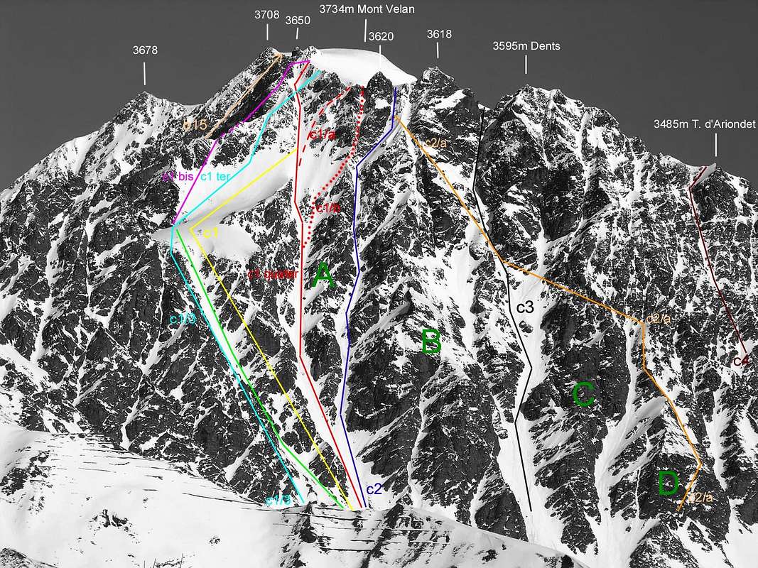
Entremont / Bagnes Valleys:MOUNT VELAN (3734m) S-SE rocky Wall and N-NE ice Face ![]() *** APPROACH: from to Faceballa Alp and to VELAN HORNS TRIPLE Western BRECHES (3605m~, 3608m~, 3628/30m~). OTHER APPROACHES toward Western By Conca/Berruard Comba (Conca = Basin; Comba = small Basin): VARIANT 1 from Glacier (1562m); VARIANT 2 from Vaud Village (1478m); VARIANT 3 from Doues-Lusey Commune-Village (1521m). c1)-
*** APPROACH: from to Faceballa Alp and to VELAN HORNS TRIPLE Western BRECHES (3605m~, 3608m~, 3628/30m~). OTHER APPROACHES toward Western By Conca/Berruard Comba (Conca = Basin; Comba = small Basin): VARIANT 1 from Glacier (1562m); VARIANT 2 from Vaud Village (1478m); VARIANT 3 from Doues-Lusey Commune-Village (1521m). c1)- From
Glacier or Glassier (1562m; Parking,
fountain) to
Rosazza at Savoie Bivouac (2674m;
fountain) on
Boégno Bà Pass (See far down
c7)-). From bivouac, by Southwest direction, long crossing in moraines and short descent (-141 metres difference in level), to
Plan Bagò (Bagò Tableland) (2533m); also by path
---> n° 3, in descent, toward alternative path in quota 2395m~ and cross, through unnumbered path to
Plan Bagò Alp (2436m; -279m to fork), between
Boégno Bà/Plan Bagò Torrents. Continue by both routes, West-southwest direction, crossing other three
torrents to
Faceballa Pasture (2385m) on
Berruard Comba, under
Mount Velan great South-southeast Wall. From Alp to cross, cleanly West direction, crossing of
Velan Horns Torrent, of
Berruard Comba moraines at
Faceballa Saddle base, in quota 2675m~, below the large East-southeast Face.
OTHER THREE APPROACHES: VARIANT 1 from Glacier Village; VARIANT 2 from Vaud Village ; VARIANT 3 from Doues-Lusey Commune-Village.
Variant 1 from
Glacier to
Faceballa Pasture, through by, West direction,
groundroad and, Northwest direction, path
---> n° 3 (to
Berruard Alp (1947m), near
Chesal Pasture (2039m). From cross path/
farm road, by West direction,
groundroad toward
Pleytau Pastures (2096m),
Praz du Champ, near
Vieille (2064m),
Econdu or Econduits (2137m) Pastures; terminal part by unnumbered path, North-northwest direction).
Variant 2 from
Vaud Village (1478m) to
Faceballa Alp (by West direction,
dirt road to
Chevrière Alp (1928m); from alp in North-northwest to
Vieille Alp and preceding route. Also in Southwest to
Ansermin Alp (2120m), near
By Ru. By path
---> n°2/groundroad toward
Econduits and previous route).
Variant 3 from
Doues-Lusey (1521m), by
main road to
Plan Debat (2076m; parking;
fountain). From ground place to
Faceballa Alp (by North direction, path
---> n°2/groundroad to
Ansermin Alp (2120m) and preceding route). *** From
Faceballa Alp (2385m) to
VELAN HORNS Triple WESTERN Brèches through
FACEBALLA SADDLE (3280m) Basis routes
c1)-, c1/2)-, c1/3)- and upper routes
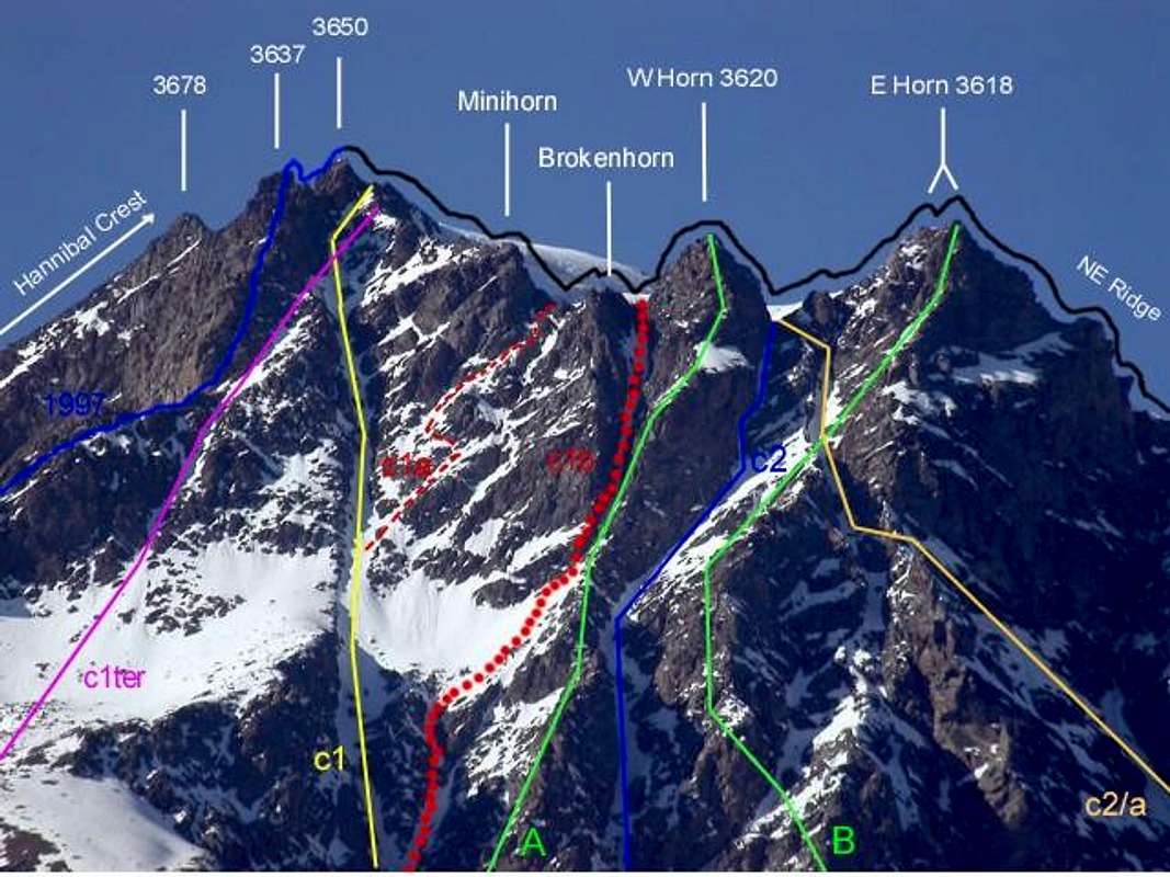
c1)-, c1bis)-, c1ter)-, c1quater with VARIANTS c1a)-, c1b)-: to
VELAN HORNS TRIPLE Western BRECHES (East 3605m~, Central 3608m~, West 3628/30m~), by
Faceballa Saddle (3280m) also directly from
Velan Horns South-southeast Wall base.
To WEST TRIPLE BRECHE (3628/30m~)c1)- From
Glacier, also previous approach routes
c1)- VARIANTS, to
Faceballa Alp (2385m) and from pasture at
Faceballa Saddle base, in quota 2675m~, below the East-southeast Face. Climb, by snowy-rocky couloir, with
three possibilities:*c1/1)- along, directly by couloir (PD-; 40°/45°; 615m), passing some rocky narrowings.
**c1/2)- by of couloir right side (North); at beginning in edge, by rocks which is breaking up with earth (I°; 50m~), and cross, near a marked "carving", in left (South) to of couloir rocky North shore (PD+; I°+/II°). Continue in border, between ice and rock, or in right and over by unsafe rocks (AD-; II°/II°+, even III°-) to large saddle.
NEVER MADE in ascent; rocks falls very many dangerous; less and less but risky in descent, since more speed.
* Osvaldo Cardellina, lone and in descent after the ascent by two third of Western Couloir (c1)-) Eastern ramification and East Gully in terminal part (
c1b)-) to
Eastern TRIPLE BRECHE, between
Mini "Brokenhorn" 3612m~ & Western Horn 3620m.
In descent: before by West Gully(c1a)-), between Mini "Brokenhorn" 3612m~ and Western Minihorn 3623m~, after by c1)- toward Faceballa Pass and, by c1/2)- to Faceballa Alp. July 18th, 1997. * Historical route: by Abbots Pantaléon Bovet and Joseph Marie Henry, Juny 14th, 1904; replay and first winter absolute Mount Velan, by same variant, Abbot Pantaléon Bovet, Evanzio Blanc and Valérien Jaccod, December 28th, 1904.
***c1/3)- through South shore, below the
Faceballa IV° or Northern Point. Climb, by better rock (AD-; II°+/III°/III°+; 490/500m~) but, paradoxically,
more rocks fallings exposed; after 430m~, abandon left the couloir South ramification to
Faceballa Pass (3239m) and go up a
mini unnominated point (3265m~), folding right (North) in terminal part to, generally snowy,
Faceballa Saddle (3280m). After continue (
c1/ter, see under) turning left (North) and, by easy snowy slope and rubbles, reach a second snowfield, in the shape of sickle, and a third circular (30°/32°/35°), between the Southwest Crest in West and South-southeast Great Couloir in East. Follow in West to a small, snowy gully and, by diagonal ascent (SW/NE) in West shore (38°/42°, even 45°; 350m~;
verglass presence;
rocks falls danger), to
Western Triple Brèche 3628/30m~, between
Quota 3650m, in West, and
West Minihorn or Quota 3623m~., in East (PD+, altogether 950/65m~).
For M Exp. and a good training; in day from
Glacier Hamlet a very deal of training. * First ascent by Osvaldo Cardellina, Luigi Gadin and Faustin Savoye Route, July 15th,
1976 and continuation, by
c1ter)- to
Western Triple Brèche 3628/30m and, through frontier ridge, to
Quota 3650m, 3672m, 3708m, Mount Velan Icy Cup Summit.
In descent: from
Western Triple Brèche 3628/30m~ , with North-northeast direction, brief and easy slope (27°) into
Valsorey Glacier, in quota 3600m~, near the trace of
Mount Velan standard route. Through the
glacier, descend on
ice tableland, between quota 3500/3350m~, below the
Mount Velan Northeast Buttress; continue to quota 3200m~ and, by brief ascent, climbing over
Mount Cordine, also turning in Northeast (
crevASSes area);
(see c6)-, c6bis)- VARIANT THROUGH
Cordine Pass or Cordine Plateau), toward
Valsorey Pass (3107m) and
Rosazza at Savoie Bivouac (2674m; on
By Conca, Italy), or Velan Cabine (2569m; toward
Valsorey Valley, Switzerland. For M (EE/A).****c1bis)- From
Faceballa Saddle go up, by Northwest direction, rubbles or snowfields (30°32°/36°) to a small snowy couloir, at base, of Southwest Ridge, two pinnacles, in quota 3365m~; by sinuous debris also snowy (32°/35°/37°) route to
Little Saddle 3450m~ of crest. Follow briefly the ridge to a first rocky elevation (I°+; 30m; exposed in Southeast, with wall 130m~ in high) and turn right (East); doubling, under a
Rocky Head 3637m~, in quota 3515m~, the South Wall. Reach a rocky ribbing and, with North direction, overcome and join at route
c1)-, in quota 3590/95m~. Exit out in
Western Triple Brèche 3528/30m~, near
Quota 3650m and between this and
Western Minihorn 3623m .
* First ascent: by Gino Buscaini-Silvia Metzeltin Buscaini Route, October 31th, 1970; through
Faceballa Saddle West Slope ascent (
See b16)-) (PD+; II°/II°+; from Little Saddle 140/5m~).
For MExp; same remarks. In descent same route and
same remarks of
c1)-.
For first mountaineers, October 31th, 1970, descent by Southwest Face (Molline/Menouve), new and direct route into
Mount Velan Glacier and toward
Etroubles Village.
*****c1ter)- From
Faceballa Saddle (by route
c1/3)-, see above) go up, by North-northwest direction, rubbles or snowfields (30°/32°/35°) to a small diagonal snowy couloir, at base of rocky head 3565m~ South Wall; climb left/right (SW/NE), by a very narrow snowy gully (35°/38°/40°, even 45°;
verglass presence;
rocks falls danger) to route
c1)-, in quota 3575/80m~. Exit out in right (East) against
Western Minihorn 2633m~, in right of
West Brèche 3528/30m~.
* First ascent: Osvaldo Cardellina, Luigi Gadin and Faustin Savoye Route, July 15th, 1976, by Variant c1/3)-
in initial part .
For MExp and, in day, same remarks. In descent:
For first mountaineers, July 15th, 1976 through entire and integral Mount Velan Northeast Buttress from
Summit to
Valsorey Pass.
Route partially realized, in superior part, by two Great Saint Bernard Monks D'Allèves and Marquis, on 1826. Also
by c1)-.******c1quater)- DIRECT ASCENT, by South-southeast Great Couloir. From
Faceballa Alp (2385m), by Northwest direction, rubbles, debris at Great South-southeast Couloir enough large base, in quota 2700/10m~; reach the narrowing 2803m against the Southwest Face of
Eastern Horn South Pillar. Continue to a second double narrowing at South base of
Western Horn South Pillar, in quota 2915m~; leaving right (East) the Eastern ramification, climb, by progressive snowy double gully (32°/35°/37°), to quota 3030/70m~ (balconies in right, with Eastern couloir branches connection possibility). Go up other 230m~, by a narrow gully in the shape of Y, to and between two higher large snowfields (circular in West, in the shape of upside beak in East), 100/20 metres~ up
Faceballa Saddle, between quota 3380/3400m~; continue, by a linear small couloir in direct ascent in West side (small rocks I°/II°; 150 m~; various
a jets water) to a debris balcony. Before again to left, by some more difficult rocks (II°/II°+; 50m) against a vertical wall, after to right (East). Cross the couloir (
often verglass) and, by East rocky side or by ice gully (II°+/III°-; 40°/45°; 40m~), vertically to summital crest (
West Triple Brèche 3628/30m~; PD+; 920m~;
rocks falls along the whole ascent; better in descent, because more speed).
For MExp; in day, same remarks.
* Historical route: first couloir absolute, in descent, by Ellis Carr,William Martin Conway and Swiss Mountain Guides Ulrich Kaufmann, Joseph Marie Lochmatter, August 16th, 1890 ( small variant in Southwest Crest, start of descent; after on couloir, by various zigzags). ** First replay and first in ascent (by VARIANT c1)-), by Abbots Pantaléon Bovet and Joseph Marie Henry, June 14th, 1904; third and first winter absolute Mount Velan (by same VARIANT and first integral of couloir descent) by Abbot Pantaléon Bovet, Evanzio Blanc and Valérien Jaccod, December 28th, 1904. Fourth route ad third ascent on 1927; partial in ascent (two third) and variant c1b)- and descent by combination of routes c1a)- / c1)- / c1/2, by Osvaldo Cardellina, lone, July 18th, 1997; third in descent and second integral, by Osvaldo Cardellina, lone, on September 27th, 1998, after first ascent Eastern Velan Double Horn South-southeast Pillar. In descent see c1)-. To CENTRAL TRIPLE BRECHE (3608m~) ![]()
c1a)- from
Faceballa Pasture, by routes
c1)- and, in particular,
c1quater)- to South-southeast Great Couloir between two snowfields in quota 3380m~; turn left (Northeast) and, by the snowfield in the shape of "upside beak", cross to a first (West), snowy, very narrow and winding/diagonal gully. Climb by snowy slope (40°, even 45° in terminal part), also in late Summer, by enough difficult and broken rocks (II°/II°+/III°-); by a diagonal W/E in terminal part, exit out near and in left of
unnominated Quota 3612m~ or Mini "Brokenhorn" In descent likewise c1)-. For M very Exp. a good training, in day from
Glassier Village (1562m), also from
Plan Debat (2076m), near
Champillon Alp (2050m)
for a far better training.
* For first ascent see above c1quater
and combinations of VARIATIONS (in ascent through two third of the Great Central Couloir (C1), for a bystander in the same on her Oriental ramification and by a small and narrow gully in final part (C1b); in descent by a narrow passage in ice more to West (C1a; traced ----- in red color), Central Great Couloir on higher slope (C1) and the couloir from Faceballa Saddle towards the snowy and morainic cone of the base (C1/2; traced in green color but not initialed in the underlying photo in B&W); Osvaldo Cardellina, lone, July 15th, 1997). To EAST TRIPLE BRECHE (3605m~)c1b)- From
Faceballa Pasture, by route
c1quater)- to South-southeast Great Couloir, in quota 3190/3200m~; climb in diagonal right (W/E), by snowy (45°/50°) or rocky gully against Southwest Face of in the shape of "Hourglass Pillar" (
A in photo, II°+/III°-; 120m~;
rocks falls danger for suspended material from two lateral sides ) to hanging snowfield in the shape of "upside beak" at right vertex. Go up, by a very narrow snowy gully (42/45°; 50m~); before, brief, turn in rocky diagonal left (II°+; 20 m). After, again snowy, in vertical, by hardly more large gully (50°, even 55°; 65m~;
rocks falls danger, same remarks to terminal part small wall (II°+/III°-; 18/20m) and exit out on snowy
East Triple Brèche (3608m~), between
Quota 3612m~ or Mini "Brokenhorn" and
Western Horn 3620m.
For M very Exp., a good training. In day, from
Glacier to
Glacier and
Mount Velan Summit (3734m),
for bestial & fantastic Mountaineers (4500m~ diff. in lev.). In descent likewise c1)-.
* For first ascent see above c1quater)- / c1a)- VARIANTS combinations (
C1a-;
traced ... in red color in B&W picture below).
*** From Faceballa Pasture at base of direct route c2)- and indirect "illogical" route c2a)- to EASTERN HORN BRECHE (3610m~); virtual routes c3)- to JAG BRECHE (3557m) and c4)- to ARIONDET BRECHE (3480m~).ROUTES to VELAN HORNS terminal parts and exits out ![]() c2)-
c2)- From
Glacier Village, also previous routes, to
Faceballa Alp and from alp, by Northwest direction, crossing
Berruard Torrent in
Berruard Comba, grassy and moraine to
Mount Velan South-southeast Face at base between two
Horn Southern Pillars (A and B in picture), in quota 2705m~. Go up, by a snowy double winding couloir, before large, after always more narrow and
dangerous to quota 3420m~; climb, by a diagonal snowy hairpin bend to of
Eastern Double Horn Great South Pillar, in quota 3550m~. Exit out, by a very narrow, steep and snowy gully, with small rocks to
Western Brèche (3610/2m~), summit crest, near the
Western Horn, between with
Eastern Double Horn.
In ascent, a lot of dangers route rocks falls exposed; Never Made. For M very Exp. and, in day, a very good training. In descent to South:
* first, by Osvaldo Cardellina, lone, by gully route, after the first ascent Velan Western Horn Southern Pillar or "Hourglass Pillar", between the Western Great Couloir and Second Long Narrow Couloir, July 25th, 1997.
Same remarks;.
In descent to North: also go down on
Valsorey Glacier, in quota 3575m~, with North direction, crossing a narrow longitudinal bergshrunde (thick concealed) and moderate snowy slope toward
Mount Velan standard route (See
c1/3 and above in general;
traced - in color lilac in B&W picture below).
*c2a)-
* HISTORICAL, but illogical VARIANT From
Faceballa Alp, by North-northwest direction, grassy and morenic slope, directly and along
Berruard Torrent, to the plinth-base of
Velan Jags "Angular Broken Double South Pillar", in quota 2520/25m~. Go up, before by steep grassy/rocky slope, after, moving in edge and climb, by enough easy rocks against of
Velan Jags Southeast Wall, in quota 2590m~. Cross left (West) upon a first secondary couloir and, by more difficult rocks, reach a second Great Couloir, between
Eastern Velan Horn/Velan Jags (C/D in photo) Pillars. Continue, Northwest direction, and to cross, before a small crest in quota 2790/2800m~. After, by more steep rocky or snowy difficult plates (
delicate; exposed rocks falls), below the "Broken Pillar" and up the "Streched Pillar" (both no marked in photo), to
Eastern Velan Horn Pillar> in the more slender point, in quota 3490m~, joing the
c2 route and finish between
Eastern Double Horn/Western Horn, more near thys last (verglass extant possibilities).
Route very long and rocks fallings more exposed. Realized for exit out from Southeast Wall, by
* Antonio Frisoni, Cesare Negri, Luigi Vavassori and Carlo Virando, Juny 28th, 1920.
For M very Exp. and a good training. In day, same previous remarks and observations; traced - in color orange.
In descent: for c2)-, c2a)- same previous remarks: descent to
Valsorey Glacier, 25/30m~ downstairs, near of
Mount Velan standard route trace (long crevice, often secluded) in South-southwest/North-northeast direction, transverse the normal route).
**c3)- From
Glacier or preceding routes to
Faceballa Alp ; from pasture, by North direction, grassy slope and steep moraine, between the
Faceballa Third/Fourth Torrents, at of
Velan Jags Southeast Wall base in quota 2793m. Go up, by difficult face on Double Great Central Couloir; before along, after under "Hanging Pillar" (below the
Western or Five Velan Jags ; no marked in photo and placed between
B/C) to route
c2/a, in quota 2800m~. Also, through couloir Western ramification, by a steep narrowing (45°, even 50°; 150/60m~; not traced in photo), again large couloir (40°/43°) to route
c2/a, in quota 2930/40m~. Climb, by a long and narrow gully to summital crest of
Velan Jags Brèche (3557m~), between
Eastern Velan Double Horn/Fifth or Western Velan Jags.
Never Made; partially, set course, in crossing on 1920. Same remarks and observation of c4)- ;
very dangerous route.
In descent go down on
Valsorey Glacier, by North direction, small rotten rocks (I°+; 35/40m~; verglass possibility), brief snowy slope (38°; 20/25m~) to half circular bergshrunde (better in East), in quota 3590m~. To cross to
Mount Velan standard route, by more easy snowy slope (28°/25°), in quota 3555m~. Or in crossing, amongst
Antesummit West-Velan Five Jags-Antesummit East/Ariondet Head, by border rocky ridge, passing through snowy
Head Ariondet or Riondet "Carving" (3480m~).
For M (EE/A).
VELAN HORNS & JAGS SHADOWS ![]()
c4)- From
Glacier c1)- to
Faceballa Alp; from, by Northeast direction, grassy slope, steep moraine, along the
Faceballa Third Torrent, at of
Velan Jags South-southeast Wall base, in quota 2793m. Turn Northeast, doubling
Velan Jags "Angular Broken Double South Pillar".
*** From "Angular Broken Double Southern Pillar" the Wall is divided into two parts: to left (West), looking from South (Aosta Town), the South-southeast Face; to right (East) East-southeast Face, declining by frontier Northeast Rige to
Ariondet Pass,
Ariondet Head,
Capucin Pass,
Mount Capucin, Velan Finger,
Chamois Pass,
Mount Cordine,
Cordine Pass or Cordine Plateau (For the Smugglers "Passer (de) Cordine" (to transport the "Spalloni" or the of cigarettes charge) from
Switzerland to
Italy) and concluding above
Valsorey Pass (3107m). The clear difference early in the morning, with South-southeast Face dark and gloomy in the shade, whereas the East-southeast blazed, with sun. A marvellaous spectacle to Velan Faces and "incended" Great Combins at every daybreak from of my home window!. To begin right of "Angular Broken Double South Pillar" on mini steep basin/slope, among of
Velan Jags "Angular Broken Double Southern Pillar"/of
Ariondet Head South-southeast Wall/East-southeastern Ridge, in quota 2860/2870m~. By a sole snowy and large couloir, in initial part, to quota 3100m~, as far as, against the wall, is divided in various gullies (the major to North-northeast, with two intermediate rocky narrowing: the first a middle course, the second in terminal part under and to
Ariondet Pass).
Practicable?; at any rate much dangerous route.
c4bis)-, c4ter)- Beginning VARIATIONS: 1)- to begin at once in right of "Angular Broken Double South Pillar", in quota 2720m~ and go up, by a small gully, or through parallel in East little crest, joing the
c4)- (no marked in B&W photo) route in quota 2850/80m~.
2)- Or to start left of "Angular Broken Double South Pillar" (between
C/D Pillars), in quota 2700m~ and near the
source of Faceballa Third Torrent; go up, in initial part, by morenic cone and a secondary couloir (no signed and standed out in extreme right and below
c4 in B&W photograph) to a in the shape of upside fork snowfield, in quota 3000m~. Continue in direct ascent, by a difficult and hard rocks to previous
c4)- route, in quota 3130/50m~.
Either this "via" is very dangerous, since rocks fallings exposed. By very steep, difficult face with
rotten and dangerous rocks, or by a very narrow and steep snowy gully, to
Head Ariondet "Carving" (3480m~), between
First or Eastern Velan Jags/Ariondet Head.
NEVER MADE, a sole attempt, by an unknown mountaineer, and return, after 230/50m~, by helipcoter, in the end of Nineties at beginning XXI° century (Private informations, by a cows shepherd in Tsa Porchère Alp, on July 27th, 2007).
For M very Exp. To foresee a rough and hard climbing by steep, rotten and difficult rocks, amongst couloirs, gullies and crests. Very dangerous ascent, motive the great exposition rocks fallings and very bad rock quality.
In descent: by small rocks and brief snowy slope to
Mount Velan standard route on
Valsorey Glacier, in
ice tableland quota 3475m~, only in advance of progressive and steep of
glacier slope (47°/45°/40°, in descent), in normal route. (See
c7)-); through the
glacier slope and by
c7)- route toward
Valsorey Pass, or
Velan Cabine.
For M (EE/A). Easy too the crossing in ridge between
Mount Capucin/Velan Jags (I°+, a brief passages II°-/II°+) to
Velan First or Eastern Jag).
For M Exp.S-SE FACE: COULOIRS/Gullies, SADDLES/"Carvings" and PILLARS ![]()
*** From
Glacier or Glassier (1562m) toward
Bagò Tableland, also to
Rosazza at Savoie Bivouac (2674m) and from both routes to c5)-
CAPUCIN PASS (3376m); c6)-
SOUTHWESTERN CHAMOIS PASS (3259m); c6bis)-
SOUTHEASTERN CHAMOIS PASS (3220m~); c6ter)-
CORDINE PASS also CORDINE PLATEAU (3190/200m~). c5)- From
Glacier to
Rosazza at Savoie Bivouac (2674m); from bivouac, by West-northwest direction, grassy slope and moraines, up
Bagò Tableland, at of
Ariondet Head/Mount Capucin Southeast/Southwest Faces, in quota 2663m; doubling left (West) the
Ariondet Head, below the great E-SE Ridge. Go up by morainal cone to a large and great snowfield, between the "Angular Broken Double South Pillar" in West and the same great crest; reach in quota 2800/5m~ and to abandon leaving in left, near and against the crest
(reason rocks fallings, very dangerous). Climb in rocky Southeast great crest, between a sinuous gully in left (Southwest) and a large couloir in the shape of Y, in right (Northeast); start in base more large, before in small edge, enough easily, but by bad rock (II°/II°+) after in ridge hotter and hotter more narrow, by on average difficults, to of
Ariondet Head terminal wall, in quota 3370m~. Conclude, by, in Northeast direction, rocky cross (III°?; before bad rock; 60m~; after by
glacier 70m~; in total: 150m; exposed to Southeast, in initial part) to
Capucin Pass (3376m), between
Ariondet Head/Mount Capucin.
* First ascent July 25th, 1916, by Mario Borelli and Nunzia Borelli, in 8 hours from base and crossing, through Valsorey Glacier to
Mount Velan Summit (3734m).
The winding couloir in West and the, in shape Y, couloir in right non precticable for very danger rocks fallings; although, by Y Gully,
sole possibility direct ascent to
pass.
For M vey Exp. and good training; in day from
Glacier for M a very good training. In descent easily and briefly, by moderate (30°/27°) snowy slope on
Valsorey Glacier, in quota 3350/60m~ and see
c4)- in terminal part.
For M (EE/A). Easily as well the crossing between
Mount Capucin/Ariondet Head (I°/I°+).
For M Exp., in crossing.
c6)- From
Glacier to
Rosazza at Savoie Bivouac; from, by West-northwest direction, traces among Cyclopian boulders toward
Plan Bagò Torrent, in quota 2725m~; leaving right (North) the great snowfield (route
c7)- to
Valsorey Pass), continue to West by a snowy tongue toward a second circular snowfield. Same direction, reach a morenic couloir (
torrent in drying process); same along, also in left through grassy slope, by rubbles, progressive steep moraines (or small snowfields at the beginning of season) at of
Doigt du Velan (Velan Finger) Southeast Face, in quota 3025/35m~. By a snowy (I°+/ II°-; a passage II°+ in terminal part, near a rocky block; 35°/38° in snowy; frequently
ice presence), or debris, couloir
(Shammyi Couloir), very narrow in high
(rocks falls danger), to
Southwestern Chamois Pass (3259m), between
Mount Capucin/Mount Cordine. In descent, briefly and easily to descend into
Valsorey Glacier and by
c7)-route toward
Valsorey Pass, or
Velan Cabine. For M (EE/A) and Hunters Exp.: in descent for M.
c6bis)- From
Glacier to
Rosazza at
Savoie Bivouac; by previous
c6)- route to quota 2835/50~. Change abrupt in North-northwest direction and reach the
Southeastern Chamois Pass basic couloir in the shape of perfect funnel, against
Mount Cordine Southeast Wall and near a perpendicular oblong snowfield, in quota 3000m~. Doubling in left the
Mount Cordine East Shoulder Southern Edge, to start on rocky-snowy and narrow gully, by, before in direct ascent after turning hardly in right, hard and fifficult rocks (II°+/III°; 95/105m~) to more large central snowy. Cross right/left reaching the of couloir second part, in quota 3145/55m~ (40°, even 45°; 55/60m~). Changing direction in Northwest, by a very narrow and steep rocky gully, with difficult and exposed rocks (II°+/III°/III°+; 75/80m~; in all 235/40m~) exit out to
Mount Cordine East Shoulder or
South-eastern Chamois Pass, in quota 3240m~, near much steep terminal part of
Mount Cordine Northeast Ridge.
For MExp. and of mountain fine connoisseurs. In descent into
Valsorey Glacier, by of
c6)- ,c6ter)- routes and return to
Valsorey Pass (3107m) and
Rosazza at
Savoie Bivouac (2674m) (
Italy) or
Velan Cabine (2569m) (
Switzerland). For M (EE/A) and Hunters Exp.. c6ter)-
VARIANT from
Glacier also from
Rosazza at
Savoie Bivouac (See under
c7)-). From bivouac, through same route
c6bis)-, in initial part, of
Valsorey Pass toward a snowfields series, in quota 2750/850 m~; from this point abandon there route, leaving in East, and, by grassy slope, rubbles, blocks and debris at
Mount Cordine Northeast Crest base, in quota 3065 m~ near a large basis snowfield. Climb in rocky band, by a debris couloir (I°/I°+; 55/65m; no forced route and various ascent possibilities), to summital crest, near the sometimes snowy
Cordine Plateau, in quota 3190/200m~.
In descent: on
Valsorey Glacier, in quota 3200m~ by a brief, moderate (27°/8°) and snowy slope; turn doubling right the small Northern "Eperon" (
numerous crevasses area) and, with "soft" ascent, toward
Mount Velan standard route, in quota 3245m~. Also from plateau continue to
Mount Cordine and go down by
two possibilities: 1)-: before and near the Summit, by a snowy diagonal in North-northwest Slope (30°/32°; 110/15m~);
2)-: cross the
Cordine Summit and descend, by, of short North Crest, easy rotten rocks, with soil and mud, to same point.
Passage for Hunters and, in old times, meaningful for the Smugglers, when the Valsorey Pass with great and dangerous corniches. At present, only just, deserted.
*** From Glassier (1562m) also from Rosazza at Savoie (2674m) to c7)- VALSOREY PASS (3107m); descent in Valsorey Glacier and crossing to Velan Hut (2569m). VARIANTS: c7/1)- from Valsorey Glacier to Gouille Pass (3149m), Velan Hutte; c7/2 from Great Tableland to Valsorey HUT (3030m); c7/3)- from Grand Plan Chalets d'en Haut, d'en Bas, Bourg Saint Pierre, with speed return to ITALY, by Great Saint Bernard PASS (2469m), State Road n° 26, or Great St. Bernard TUNNEL.BY CONCA from Amiante-Chiarella Refuge ![]() c7)-
c7)- From
Glassier (1562m; Parking,
fountain), by North direction, path
---> n° 3, 4, 5 to
Cheval Blanc Alp , near
Casa Farinet (1962m;
+ little church;
small dam-lake 1877m); from church, by West direction, groundroad
(not thoroughfare for cars) and path
---> n° 3 to
Porchère Alp (2102m), and, by North-northwest direction and path
---> n° 3, to
Porchère Pasture (2290m,
source to Northwest). From Pasture, by North-northwest direction, path
---> n° 3, along and in crossing on
"Dos de Boégno bà" (to drop ear hump) to
Rosazza at Savoie Bivouac (2674m;
fountain) on
Boégno Bà Pass. From bivouac, by path-traverse in Northwest and short descent, to the
source italian Valsorey Torrent (2675m;
splendid water!). Continue among Cyclopean bulders (cairns) to a first great snowfield (in summit confortable "salle à manger", with
water under the blocks); go up, by traces and small friable path, leaving in West a broken rocks strip toward the snowfields of terminal part. Nearby summital crest (50/60 meters~ below) to climb, by rotten rocks (I°), before in vertical ascent, after by a brief (I°+; 15/20 metres; easy but delicate and in South exposed) traverse to right (East), through a debris narrow balcony, up a small steep rock; by a brief cross in rubbles also snowfield (35°/37°), with possible frame in final part (50°, even 60°; to overcome, by direct ascent, also through a brief crossing in left against the of Northeast Crest rocks), below the
Valsorey Pass (3107m), between
Mont Cordine/Valsorey Trois Frères. In ascent
For M (EE/A). In descent: by North direction, broken and friable rocks, to
Valsorey Glacier, in quota 3200m~
(part very exposed rockfalls). Crossing, by North direction (séracs to West), bording in West the small spur of Quota 2953m to ice tableland in quota 2750m~; from
"plateau", by North-northeast direction, slopes with
crevasses, brief ascent, to lateral right moraine of
glacier. Go down, by traces in moraine, toward
Valsorey Great Tableland, in quota 2502m; from
Grand Plan to:
c7)- level route, by Southwest direction, small path, crossing of
Valsorey Torrent, more branded path
to junction 2524m (with path
from Chalets d'en Haut; 2200m),
Velan Hut (2569m), below
Tseudet Glacier and
Gouille Mount,
Gouille Pass.
For MExp. VARIANT: c7/1)- from
Valsorey Glacier, through traverse in quota 3100m ad brief ascent to
Gouille Pass (3149m) and descent, by Northwest direction, crossing
Tseudet Glacier , below of
Gouille Mount Northwest Spur to
Velan Cabane. c7/2)- From
Grand Plan, with Northeast direction, path good marked to
Valsorey Cabane (3030m~). From
Valsorey Pass, in descent,
for M Exp. (EE/A); from
Bourg Saint Bernard, in ascent,
for Hik. Exp. (EE). c7/3)- Go down, by Northwest direction toward the
Chalets d'en Haut (
Upper; 2200m~),
Chalet d'en Bas (
Lower; 1976m) in
Valsorey and to
Bourg Saint Pierre (1632 m, near great
Mauvoisin Dam) in
Entremont Valley.
* --->Speed return to
Italy from
Bourg St. Pierre (1632m, near great
Mauvoisin Dam, along Drance Stream), in
Entremont Valley, by
Swiss State Road n° 114,
Gr. St. Bernard Pass (2469m) and
Italian State Road n° 26, or
Great Saint Bernard Tunnel.MOUNT VELAN Standard Route, by NE Ridge ascent and descent, with BAD WEATHER but GOOD CONDITIONS AUGUST 18th, 1975
*** From Glacier also from Rosazza at Savoie (2674m) to c7)-
VALSOREY PASS (3107m); c8)-
Southwestern MOLARS BRECHE (3178m)
MOLARS "CARVING"; c9)-
Northeastern MOLARS BRECHE (3180m~); c10)-
SADDLE 3140m~ and c10bis)-
Variant; c11)-
GRAND CARRE PASS (3294m); c12)-
MONT PERCE PASS (3317m); c13)-
LUISETTES PASS (3401m); c14)-
VERT PASS (3395m); c15)-
AMIANTE PASS (3308m); c16)-
CHAMPIGNON PASS (3300m~); c17)-
BY PASS (3224m); c18)- ;
FILON PASS (3251m); c19)-
MOUNT AVRIL PASS (3190m); c20)-
DURAND FENETRE PASS (2797m); c21)-
MONT de la BALME PASS (3320m) and
VARIANTS c21bis)- , c21ter)- . c8)- From
Glacier, through previous route, to
Rosazza at Savoie (2674m); from bivouac, with North direction, grassy and rocky South Crest
Western Point Valsorey Trois Frères to a triangular wall. To double right (East), through steep and subject to landslides slopes in great diagonal balcony from left (Southwest) to right (Northeast), at a snowy or debris cone in quota 3165m~, near the
Molars "Carving" (3221/2m). By direct ascent in North, to overcrome the little face, through a friable and breif gully (II°/II°+; 25/27m~), to
Southwestern Molars Brèche (3178m).
The descent to Northwest not possible, for vertical wall 265/70m~ high. Pass used exclusively for
Valsorey Trois Frères/Valsorey Five Molars ascent. Return, through crossing in North-northeast direction to
I°/II°/III°/ Molar and
Northeastern Molars Brèche(3180m~); or, by all five
Valsorey Molars to
Saddle 3190m. Also, through traverse in Southwest direction,
Valsorey Trois Frères and
Petit Frère to
Valsorey Pass (3107m).
For M a good Exp. c9)- From
Glacier, by previous route, to
Porchère Alp and from pasture toward crossroads 2177m (
source), before by East direction, after, from quota 2209m, North along
Ru de By (By Brook) to
By Conca; go up by path
---> n° TdC (Tour of Great Combin), crossroads 2184m, cross 2157m. From alternative, through North-northwest direction, small path to
Eveques Tsa (2342m). From tsa, by traverse in Northeast direction, ruines of
Alp 2330m to
West Clavette Torrent in quota 2332m; by North-northwest direction, grassy and steep moraine, along the
torrent to
Pond 2580m (splendid bleachers!). From
little lake, through North direction, steep moraine, broken rocks, snowfields, to double left (West) the promontory quota 2684m. Continue by Northeast direction, snowfields (30°/35°) to a second quota 2931m; in quota 2945/~ turn left and, by steep snowfield in mini couloir (38°/42°), to go up at face base in quota 3020m~. Climb, by a crack, a diagonal balcony, a slit, a cliff (III°/III°+; exposed; delicate for grassy up rock) to very narrow
Northeastern Molars Brèche, between
III°/IV° Molar (3180m~).
In descent to North not possible, for high and vertical wall about 450m~; pass used exclusively for
Five Molars ascent.
For M a good Exp. c10)- From
Glacier, through preceding route to quota 2945/50m~ and, by Northeast direction to double right (East) a rocky band or climb (I°/I°+ passages, amusing) to upper snowfield (
abounding sources); turn left (North) and, by snowy moderate slopes, broken rocks, rubbles and slush, to
Saddle 3140m~, between
Luisettes Aiguilles/Le Rateau (The Rake).
In descent: same obervations and considerations of previous route.
For M (EE/A). c10bis)-
Variant: from
Chiarella Amiante Refuge (2979m), by Northwest direction, traces in moraine, Eastern ramification
By Glacier to
Garrone Pass (3265m~); from pass, through traverse in quota 3300m~ doble Southwest Spur
Great Tete de By to South and West ramifications and
in descent: toward West preceding route.
Popular enough traverse Chiarella-Amiante Refuge/Rosazza-Savoie Bivouac; for M (EE/A). c11)- From
Glacier, by preceding route, to quota 2945/50m~ and, by Northeast direction, double right (East) a rocky band to upper snowfield, before by small and brief diagonal in ascent, after by short descent to
Luisettes Glacier; through West-northwest direction, snowfield (30/38°) at East-southeast Face base, in quota 3100m~. To climb, by narrowing in the shape of funnel (42°/38°; I°/II°+;
rocks fallings danger), easily in more large terminal part to
Grand Carré Pass (3294m), between
Grand Carré/Mont Percé (Great Square and Pierced Mount).
Descent to Nortnorthwest not possible, for vertical wall 400m~; see above.
For M (EE/A). c12)- From
Glacier, through preceding route to quota 3250m~ and, by West-northwest direction at East-southeast Face base in quota 2250m~. Climb, by a snowy diagonal balcony from right (East) to West; to double a small spur in left and reach the higher snowfield or debris slope to
Mont Percé Pass (3317m), between
Mont Percé/Les Luisettes. In descent, by West-northwest Wall toward
Valsorey Glacier, in quota 3115/20m~ (a initial cliff IV°?/III°; 45°/50°; verglass possibility;
rocks fallings elevated danger). From
glacier, by West direction, to rejoin the
Valsorey Pass route toward
Valsorey-Entremont Valleys. In ascent route
for M (EE/A); in descent for M a good Exp. First and sole ascent on 1907; probably non repeated. c13)- From
Glacier, through preceding route to upper snowfield in quota 3225m~; to turn left (West), below the Southeast Face of
Luisettes NortheastPoint at Southeast Face of
Luisettes Pass (3401m). Reach the pass, by a small and brief gully with little rocks in diagonal left/right and a mini snowfield in terminal part (I°+; 33°/38°).
In descent, to cross through NE Crest (I°+; 50m~); after descend to
Sonadon Glacier in altitude 3280m~, by a brief snowy or debris slope. To traverse, by North direction, and to join again to
Sonadon Pass (3504m.
See c8).
For M a good Exp. c14)- From
Glacier, through previous route, to quota 2945/50m~ and, by Northeast direction, snowfields (30°/35°), below
Valsorey Aiguilles small Mountain Chain, to narrowing 3200m~; cross in right (South) towards
By Glacier. Go up, by Northeast direction,
to Vert Pass (3395m), between
The Sphink/Amiante Peak. In descent to go down, by North direction, enclosed steep couloir (42°/35°) to
Sonadon Glacier, in quota 3285/90m~. From
glacier three possibilities: 1)- to cross, by Northeast direction, and go up to
Sonadon Pass (3504m),
Durand Glacier, crossing North/South of
Amiante Pass (3308m); through
By Glacier to
Chiarella/Amiante Refuge and return in
By Conca. 2)- By previous route to quota 3420m~, up of séracs fall; turn, by Northwest direction, and in descent double in quota 3070m~ the
Great Isler Shoulder, in altitude 3048m. Cross the
Meitin Glacier, snowfields, moraine in false plane route toward
Valsorey Cabane. 3)- From quota 3048m descend directly, by West direction, lateral right moraine of
Sonadon Glacier, towards
Valsorey Great Tableland, in quota 2500m~. Same of preceding routes remarks.
For M a good Exp. and a lot of training.
![]() c15)-
c15)- From
Glacier to
Casa (House) Farinet by route
C1/1 into
By Conca. From
House, by North direction, dirt farm road and path
---> n° 4 towards
By Municipality Pastures (2050, 2049m), near
By Torrent; By Lake (2165m) 750m~ Eastward; from pastures, by Northeast direction, crossing
Grande Maison Torrent (Great Home) in quota 2200m~ to
Tsa Commune Alpage (2304m) in
Tsa Commune Comba. From alps, by long diagonal in North-northwest, below
Ratti Point, cross
Amiante Torrent in quota 2518m; by more steep terminal part
(chains in quota 2865m~ or passages I°+; 50/60m~), easy debris diagonal to right to
Amiante-Chiarella Refuge (2979m), in splendid debris plateau. From refuge, by North-northwest direction, moraines alog three small
torrents, snowfields (30°/35°) easily to
Amiante Pass (3308m).
In descent two possibilities: 1)- by snowfields (30°) to
Durand Glacier at base of
Great By Head Northeast Ridge, in quota 3285m~. Double right (East) and, by delicate traverse in icy-balcony, between upper slopes and lower séracs fall up great rocky fall (120m~, with good waterfall to
Durand Glacier);
(from year to year variable route and went by *** : a sole ice-bridge in existence; to pay attention to noumerous crevices). To cross, before by North-northwest direction, to
Grafeneire Great Combin Southeast Ridge, in quota 3425m~; after definitely by West direction to
Sonadon Glacier and
Pass (3504m). From pass, by preceding route
c8, toward
Valsorey Cabane. For M (EE/A) in ascent; for M Exp. in descent and crossing to Hut.
2)- From pass, just at of descent beginning, turn right (North-northeast) and, through
Durand Glacier to cross entirely the
glacier, below
Tête Blanche, Tête du Filon, Tête de Balme Northern Faces. Continue by East direction to
Mount Avril Northeast Spur and double
:a)- in quota 2750m~,
shoulder 2736m and, through rubbles and grassy slopes, go down to path
---> n° 5, TdC of
Fenetre Durand Pass, nearby
Chermontane Torrent and main road of
Great Chermontane Alp (2256m). From Pasture, by dirt road and path, to
Chanrion Hut (2462m) in
Bagnes Valley. b)- More descend by
glacier to quota 2400m~ and to steep over
Mount Avril Northeast Crest and go down to previous route by analogous course toward
Fenetre Durand Pass path.
For M Exp. in descent.
In typical expression valdotain language: "à vatzè's" (for cows).
![]() c16)-
c16)- From
Glacier to
Chiarella Amiante Refuge, through preceding routes; from shelter, through Northeast direction, rubbles, small snowfields and a narrow couloir in terminal part (30°; I°+) to
Champignon Pass (3300m~), between
Amiante Pass/
By Tete Blanche. In descent, by brief snowy slope (35°/38°), to
Durand Glacier, in quota 3210m~ and previous route
c15/2. For M (EE/A). c17)- From
Glacier to
Chiarella Amiante Refuge; from refuge, by East-northeast direction, rubbles, small snowfields,
By Tete Blanche initial route and by
Upper Gabelou Pass (3129m); from pass, by Northeast direction and same typology, to
By Pass (non always snowy) (3224m), between
By Tete Blanche/Tete du Filon. In descent, by easy snowy slope (30°/25°)to quota 2990m~, under
By Tête Blanche East-northeast Face; leaving in Northwest small crevasses area, join with previous routes.
For M (EE/A). c18)- From
Glacier to
Casa Farinet by route
C1/1 and from
House, through East direction, dirt ground farm road and path
---> n° 5 toward
Balme de Bal Alp (2128m); from pastures
(source and other sources 300m~, 600m~ in Northeast), through Northeast direction, groundroad or path
---> n° 5, TdC, to
Lombardin Alpages (2309m;
source; Thoules Lakes 2318, 2326m, in Northeast). From dirt road, 250m~ in advance the pasture, by a large tour before in West-northwest direction (short cut in North to
Alp 2421m), after in Northeast to
Filon Alp (2478m); from alp, through various traces in pasture land, to
Filon Torrent, in altitude 2500/2525m~ and along, by North direction, to
Filon Tableland, in quota 2625m~. Traverse, along the
torrent, and go up, through grassy slope and rubbles, at narrowing 2808m; this way to get in small debris conca and, by moraine more and more steep, reach a rocky strip, below the pass. Double left (West) against
Filon Testa East Crest and easily to
Filon Pass (3251m), between
Filon Testa/Tete de Balme. In descent, by North direction, a steep but brief snowy slope (38°/35°; 120/5m~) to
Durand Glacier, in quota 3100m~ and, through preceding routes, to
Chanrion Hut or toward
Fenetre Pass.
For M (EE/A). c19)- From
Glacier, by preceding route, to
Thoules Alp (2381m). From pasture, by North direction, path
---> N° 5, TdC to quota 2449m, near the junction of various
Fenetre Torrent; go up, by North direction, a little wild walloon towards at beginning of three Northwestern
sources, in quota 2725/75m~. Continue, same direction, by a long and enclosed snowy couloir, debris and steep rocky band, in terminal part (I°/II°; 110 m; delicate) to
Mount Avril Pass (3190m), between
Tete de Balme/Mount Avril. In descent, through a small and brief snowy slope (38°/35°), to
Durand Glacier, in quota 3135m~. Same remarks of
c12.
For M Exp.. c20)- From
Glacier, by preceding route
c19, to
Lombardin Alp (2309m;
source; Thoules Lakes 2318, 2326m, in Northeast. From pasture to
Thoules Alp (2381m), near
Fenetre Torrent and along the
torrent sources-small torrents; from
Mount Avril) in Northwest, to
Fenetre Lake (2711m) and by diagonal easily to
DURAND FENETRE Pass (2797m), between
Avril/Mount Gèlé. From pass, through debris, path
---> n° 5, TdC, along the lateral left of
Fenetre Glacier moraine, to previous route.
For Hikers.
c21)- From
Glacier, through preceding route, to
Thoules Alp (2381m); from pasture, by Southeast direction and path
---> n° 6, towards
Basèya or Bonseya Lake (2513m),
Nino Regondi Bivouac (2599m), below the Western spectacular Walls of entire
Mount Morion Mountain Chain. From bivouac (avoidable, by deviation in quota ~ and direct ascent to East-southeast) towards
Mount Gelé Glacier, in quota 2774m. Cross the
glacier, weith North-northeast direction, to
Mount Gelé Pass (3180m). Double, nearby in left (Northwest), or join, and "en pente douce" reach the
de la Balme Pass (3320m), between
Mont de la Balme/Mount Gèlé. In descent, by, before, a narrow gully (50°/48°; 100m~), after, a large and steep couloir (420m~) to
Crête Sèche Glacier, in quota 2800m~ (45°/40°;
rocks fallings danger). From
glacier, by Northeast direction, to
Crete Sèche Pass route (
See d2).
For M Exp. c21bis)-
VARIANT. From
Glacier, by Northeast direction, path
---> n° 6,
Crottes Alp (1591m),
Gaula Oratory,
Places Alp (2150m), bridge 2223m above
Fenêtre Torrent in
Eaux Blanche Comba (White Waters small vallon); from bridge, by East direction, to
Corn(m)t Lake tributary, in quota 2220m~ and in
Breuil Tableland(
source in East), crossroads 2465m, between
Clusa or Inclousa/Leita or Leitou Lakes toward
Regondi Bivouac.
For Hikers. c21ter)- VARIANT. From
Ollomont-Cognen (1356m;
+ church), by Northeast direction, path
---> n° 6, 7, Alta Via 1,
source in altitude 1845m to
Berrio Damon Alps (1932m); from pastures, by path
---> n° 6, in
Berrio Comba, Berrio Tsa, Corn(m)et Pass (2354m). From pass, through brief descent, along
Lake Ru, Inclousa/Leitou Lakes toward
Regondi Bivouac.
For Hikers.
![]()
B2)- *** AOSTA VALLEY DORA BALTEA STREAM HYDROGRAPHIC CATCHMENT BAISN ALL SUMMITS of Left Side in West/East longitudinal AXIS: Ferret, Central Valleys, Aosta Town Great Saint Bernard, Ollomont, Valpelline Valleys
GREAT COMBINS and MATTERHORN from West. ![]()
B2)- *** West/East longitudinal AXIS:
Aosta Valley HALFCIRCULAR NORTHERN PERIMETER OUTSIDE AREA: from
Seigne Pass to
Ostiefmattenjoch (Eastnortheast) and
INSIDE AREAS from West-northwest to East.
ALL SUMMITS of LEFT SIDE: FERRET Valley (Courmayeur),
Doire Baltea CENTRAL Valley (Morgex, La Salle, Avise, Saint Nicolas, Arvier, Villeneuve, Saint Pierre, Sarre Communes,
Aosta Town) and GREAT SAINT BERNARD Valley (Saint Rhémy en Bosses, Saint Oyen, Etroubles, Allein) and OLLOMONT (Doues, Ollomont), VALPELLINE (Valpelline, Oyace, Bionaz) Valleys
21)- From Val Ferret to Gran Saint Bernard Hill with various small ramifications: Mont Quichette/Mont Charfière; Mont du Tapier; Aiguille de Bellecombe/Petit Golliaz; Aiguille de Saulié or des Ceingles/Saulié Aiguillon/Saulié/Quote various; Crest/Grand GOLLIAZ or Golliat/Aiguilles des Angroniettes/Pointe de Combette/Grand Six Blanc/Les Marmontains Crest/Les Grands Creux/Six des Bornettes; Les Six Potò; Les Econduits Crest; Aiguille de Leisasse/Olline Coastline/Testa Crevacol/Mont Borzalet/Testa Bassa. Unnominateds Aiguilles/Mont Fourchon/Pain de Sucre/Tour des Fous; Ven Crest/Pointe de la Fenêtre/Têtes de Fonteinte/Quota 2861m/Pointe des Trois Lacs/Monts Telliers; Pointe du Drone/Grande Chenalette/Pointe des Lacerandes/Les Lacerandes; Petite Chenalette. Subgroup above Great Saint Bernard (I)/Entremont (S) Valleys.Summer 2007 & Winter 2004 with Southestern View PAIN de SUCRE (2900 metres) & MOUNT FOURCHON (2902m) in multiple times in different seasons, by emilius and ronfo
22)- From Grand Saint Bernard Hill to Hannibal Pass and small Southern Appendages: Mont Mort-Testa di Barasson; Barasson Coastline/Mont Tchoume/Plan Puit(z). Punta di Barasson; Quote various/Monte Paglietta/Mont Morteret; Tchola(e)ire Crest (Tête Verte or Babylone, Tête Rouge)/Bec Noir/Becs Noirs Crest; Mont Menouve or Menovy/Quota 2955m/Grande Mol(l)ine; Pointe Rayons de la Madeleine/Pointe de Crête Sèche/Pointes de Moline/Mont Tunnel/Tête Grise/Hannibal Ridge. From Mont Velan to Northern long Buttress: Aiguille du Déjeuner/Mont VELAN; Quota 3678m/Dome du Velan/Aiguille du Velan/Aiguilles de Proz or Quote 3561m and 3488m/Dents de Proz; Mont de Proz; Quota 3223m/Petit Velan South and North Summits/Mont Orge/Croix de Tsousse/Le Tseudet; Arête de la Gouille/Mont de La Gouille Southeast and Northwest/La Gouille; Summitals Aiguilles du Velan (Quote 3708, 3672, 3650m. Southern small Buttress: Faceballa four Points/Faudery three Points/La Salliaousa; Mont-Riond also Morion; Tete des Cretes/Mont Chenaille North and South/Crou de Bleintse or Bleinchy also de Blentze/Tete de la Praz/Mont Saron/South Antesummit. From Mont Velan to Grand' Tête de By Ridge: Velan Horns/Velan Jags/Tête d'Ariondet/Mont Capucin/Doigt du Velan/Mont Cordine/Petit Frère/Trois Frères de Valsoray/Valsorey five Molars/Aiguilles des Louisettes de Valsorey (various little tops)/Dents de Valsorey (Le Rateau-Grand Carré/Mont Percé Southwest and Northeast/Les Three Luisettes/Aiguille Verte/Valsorey Sphink/Pic d'Amiante/Mont Sonadon Group.MONT VELANS-SE GULLY, traverse, by NE Ridge, and second absolute ascent of
VELAN DOIGT (VELAN FINGER) or
VELAN Jag JULY 15th, 1976
23)- GRANDS COMBINS Mountain Chain with Buttress to North: Aiguille de Bocheresse/Combin du Meitin/Arete des Maisons Blanches (Petite Aiguille des Maisons Blanches, Le Moine, Quota 3571m, Grande Aiguille des Maisons Blanches; Six Noire; Mont Beaufort/Pointe de Penna/Tête de Bois; Quota 3605m, Aiguille de l'Epée; Quota 3215m; Aiguilles du Meitin South and North, Aiguille de Challand, Dome du Ritord, Aiguille de Ritord, Le Mérignier); Quota 3307m, Bonhomme du Tsapi. Combin de Boveyre/Combin de Corbassière; Petit Combin/Pointe de Boveire de Valsorey. Combin de Valsorey/Combin de GRAFENEIRE/Great Shoulder SE 3946m; Combin de Tsessette/Tour de Boussine/Les Gendarmes de Boussine. Mulets de Tsessette (Quote 4010 and 3695m)/Quota 3630m/Tournelon Blanc/Bec de l'Alia; Aiguille de Bocheresse or de Bagnes; Pointe de Mauvoisin or Quota 3164m/Grand Tavé/Pointe des Otanes/Pointe de Plangolly/Bec de Corbassière. 24)- On fronter Ridge from Grand TETE de BY to Fenêtre Durand and Southern small Appendages: Punta Garrone; Les Champignons West and East/Quota 3363m/Tête Blanche; Pointe Farinet; Grande Maison/Pointe Ratti; Tête du Filon; Arete de la Bonne Mort;/Mont de Balme/quote various (2559, 2454, 2323m); Tête de la Balme; Dent(s) d'Ansermin or Punta Touring Club; Mont Avril/Quotas of the NE Ridge (3231, 3046, 2963, 2904m) little Group.GRAND TETE de BYSE FACE, direct and new route
JULY 15th, 1979
25)- From Fenêtre Durand to Mont Gelé and Southern great Morion Ridge up to the Ollomont/Valpelline Municipalities: Great Shoulder 3446m or West Summit/
Mont GELE'/NE Crest (Quote various (3167, 3150m)/Pointe d'Ayace; Mont de Balme/Pointe d'Ayatse also Oyace/Trouma des Boucs Crest/
Trouma des Boucs. Becca Faudery/Becca Crevaye/punta Edoardo Gaia/Punta Alessandro Martinotti/
Trident de Faudery (Joseph-Maria Henry, Paolo Ferrario, Alfred George Topham Points)Le Due Sante (Judith and Esther Points)/Sega del Morion/
Mont Morion North (Michele Baratono, Enrico Auguto, William Douglas Monro Points)/Campanile del Morion/
Central Morion/Punta Emilio Gallo/
South Morion/Mont Clapier also du Clapey; Monte Traversagne; Punta Lino Binel/Punta Renato Chabod/Punta Jean-Baptiste Gontier/
Punta Fiorio; Pointe Aimé Gorret; Tete Nino Quaini/Tete Louis "Jean" Bonin/
Mont Berrio; little Berrio Pyramid or Quota 2478m/Pointes du Corn(m)et; Pointes d'Ollomont or du Breuson/Monte Faceballa/Pointe des Faces/Pointes des Arsines/Pointe de Sereina
Mountain Chain above Ollomont/Valpelline Municipalities. Arol(l)etta little Spur from Gelé Pass up to the Ruz/Dzovenno Hamlets in Valpelline: Upper Arolletta North and South/Bec Noir/Punta Angelo Bozzetti/Lower Arolletta/
La Vierge/Pic de la Vierge/
Trident de l'Arolletta: Punta Alessandro "Dino Charrey, Punta Cino Norat,
Punta Jean Charrey)/Pointe Duc/Berger de l'Aroletta/Aiguille de l'Arolletta/Tour du Freyty.
INSIDE AREAS AOSTA VALLEY IN WEST/EAST LONGITUDINAL AXISCOURT de BARD, PUNTE FELITA, TESTA dei FRA', TESTA di SERENA, CRESTA di CORLEANS, PUNTA VALLETTA Summits, in several times
From Courmayeur-VAL FERRET to Morgex/La Salle/Avise/Saint Nicolas/Arvier/Villeneuve/Saint Pierre/Sarre/Aosta City/Gignod/Etroubles Communes: 26)- Dora Baltea Central Valley and inside vallons from Val Ferret to Aosta Town into great triangular area with Great Saint Bernard Valley: Testa di Liconi/Testa del Currù/Aiguilles de Chambave/Petite Aiguille; Bec Aoulie (é)/Testa Nera/La Varise/Mont de la Varise/Petite Rochère/
Grande ROCHERE/Aiguille de Bonalé, Aiguille de Malatrà,
Aiguille d'Artanavaz/Grand Creton/Creton du Midi/Serena Coast line/
Testa di Serena/Testa dei Frà/Punte Felita or Fetita/Court de Bar
above La Salle Municipality. From Testa di Serena to Northeast: Corléans Crest (various elevations, the most 2663, 2807, 2782 metres)/
Punta Valletta/La Raye du Sodzé - Cote de Citrin between Quotas 2460 meters and 2208 meters .
![]() Connection from Punta Valletta to Mont Fallère:
Connection from Punta Valletta to Mont Fallère: Mont Flassin Northwest, Central and Southeast Summits;
to Northeast: Testa Cordella/Testa di Bois de Quart;
to Southeast: Quota 2758 metres/Mont Vertosan.
Into Dora Central Valley: Punta Aouillette/Punta Leissé or Leysser/Punta di Paletta/
Monte Rosso di Vertosan Southwest and Northeast/Fallère Northwestern Shoulder or Quota 2973 metres/
Mont Fallère.MOUNT FALLERE (3061m), in JUNE 25th & AUGUST 01th, 1965, APRIL 20th, 1968, SEPTEMBER 14th, 1974 & December 1982
From Mount Fallère great Northwestern Shoulder 2973 metres the ridge to Northeast above Saint Oyen/Etroubles Municipalities: Mont d'Ars also Mont d'Arsy or Quota 2707 meters/Costa Labiez also Labiéz/Grande Testa or Grande Tête.
![]() The small Crest From Mont Fallère to South-southeast above Saint Pierre Municipality: Quota 2348 metres/Becca France.MONTE ROSSO
The small Crest From Mont Fallère to South-southeast above Saint Pierre Municipality: Quota 2348 metres/Becca France.MONTE ROSSO(2943m),
PUNTA PALETTA (2707m),
PUNTA LEISSE' (2771m) &
L'AOUILLETTE (2616m), in
several times
From Mount Fallère the ridge to Southeast above Sarre/Aosta Municipalities: Costa Mayan or Mont d'Arsy also d'Ars/La Tsa.
From la Tsa to North-northeast:Tardiva Coastline;
to South-southeast: La Tsa/
Pointe Chaligne/Pointe de Met
above Sarre Municipality/Aosta City Area.MOUNT FALLERE (3061m) Southern and Northern secondaries Appendages
GRANDE ROCHERE / AIG. d'ARTANAVAZ / MONT FALLERE AREA (INSIDE AREAS in West/East LONGITUDINAL AXIS into great triangle and amongst Courmayeur/Aosta Towns with Great's Saint Bernard Valley; Ferret's Doire to West; Baltea Dora to South or Central Valley; Rio Artanavaz in NW/SE)
![]() 2)- INSIDE RANGES: Dora Baltea Stream Left Hydrographic Watershead from West to East-southeast: to Southeast from Courmayeur Tourist Town and Morgex little Town in Valdigne; to East from Morgex, La Salle, Avise, Saint Nicolas, Arvier, Saint Pierre, Sarre little Towns in Middle VALLEY to AOSTA Town (East). To Southeast from Saint Rhémy en Bosses, Saint Oyen, Etroubles, Gignod Communes in Great Saint Bernard-"Coumba Freida" Valley to (Southeast). To East, Northeast, East and Southeast from City to Saint Barthélemy, Valtournanche, Ayas Valleys (Northeast) and to Quart, Nus, Chambave, Verrayes, Saint Denis, Chatillon, Saint Vincent, Emarese, Montjovet, Verrès, Arnad, Bard, Donnas, Pont Saint Martin, Perloz little towns (East-southeast) in AOSTA VALLEY. Dora Baltea Stream (Central Valley from Courmayeur Town to Aosta City) Left Hidrographic Watershed:
2)- INSIDE RANGES: Dora Baltea Stream Left Hydrographic Watershead from West to East-southeast: to Southeast from Courmayeur Tourist Town and Morgex little Town in Valdigne; to East from Morgex, La Salle, Avise, Saint Nicolas, Arvier, Saint Pierre, Sarre little Towns in Middle VALLEY to AOSTA Town (East). To Southeast from Saint Rhémy en Bosses, Saint Oyen, Etroubles, Gignod Communes in Great Saint Bernard-"Coumba Freida" Valley to (Southeast). To East, Northeast, East and Southeast from City to Saint Barthélemy, Valtournanche, Ayas Valleys (Northeast) and to Quart, Nus, Chambave, Verrayes, Saint Denis, Chatillon, Saint Vincent, Emarese, Montjovet, Verrès, Arnad, Bard, Donnas, Pont Saint Martin, Perloz little towns (East-southeast) in AOSTA VALLEY. Dora Baltea Stream (Central Valley from Courmayeur Town to Aosta City) Left Hidrographic Watershed: M. Cormet - Grande Testa or Testa di La Suche -
Testa di Liconi (West and East Summits) and
Liconi Lake; Testa Drumiana; Testa del Currù -
Aiguilles de Chambave (Northwest and
Southeast Summits) - Quota 2727m or Little Aig. de Liconi. Little angular ramification before to Northwest, after to SW: Testa della Tronche -
Testa Bernarda (between T. Bernarda and M. de la Saxe, in Sapin Valley,
ancient goldmine, by Romans exploited) - Monts de la Saxe (various little Summits) and
Courmayeur Guides Rocky Gym above Entrèves/
Courmayeur. From
Battaglione Aosta Pass little ramification to Northwest: Grand Rochère West Shoulder or Quota 3134m -
Testa di Sécheron - T. d'Entre-Deux-Sauts - Punta di Lavachey or Quota 2644m.
From South over Planaval Morgex Fraction to Grande Rochère: Bec Aoulie or Bric Aouilé -
Testa Nera - la Varise - Mont de la Varise -
Petite Rochère or Quota 3267 meters.
Grande Rochère Area (*): Aiguille de Bonalé - Aiguille de Malatrà -
Aiguille d'Artanavaz (ski-mountaineering) -
Grand Creton (Northwest and
Southeast Summits).
From Southeast Summit to East-northeast: Pointe d'Entremont and
from antesummit to East: Tete des Faces.
To Southeast: Creton du Midi - Serena Coastline (Quote 2785, 2744, 2710m).
From Serena Pass to South: Testa di Serena (ski-mountaineering or snowshoes) -
Ziule Lakes - Testa dei Frà
Serena Lake in Northwest; Punta Ziule.
To South: Punta Felita or Fetita (
North and South little Summits) - Court de Bard. From
Serena Head to East: Corléans Crest (various little elevations, the more high 2807 meters) -
Punta Valletta Citrin little Lake in East - La Raye du Sodzé - Cote de Citrin between Quotas 2460 meters and 2208 meters. From
Citrin Pass ramification to East-southeast: Citrin Coastline - Mont Flassin ((Northwest,
Central 2772 metres and Southeast or Quota 2758m Summits) to
Vertosan Pass. From
Mont Flassin Summit small ramification to Northeast: Testa Cordella - Quota 2509m Testa de Bois de Quart.
From Joux Saddle: Punta Aouillette
(little statue Black Virgin Mary in summit) - Punta Leissè
(+; ski-mountaineering) - Punta Paletta
Leissé or Leysser Lake to West -
Monte Rosso di Vertosan
(ski-mountaineering and snowshoes) - Mont Flassin Southeast or Quota 2758 metres between
Citrin, Vertosan Passes - Mont Vertosan - Fallère Northwest Shoulder or Quota 2973m - Mont d'Arsy or Quota 2707m -
Arsy little Lakes to East - Costa Labiez - Grande Testa.
Mont Fallère Little Area (*; Cross and Vierge little statue in Summit);
Morto, delle Rane Lakes in West and
Clapin, Fallère, delle Foglie or des Feuilles Mortes Lakes in South. From
Saddle 2255m small branch to Southeast: Quota 2348 meters -
Becca France. From
Pass 2674m ramification to East-northeast: Costa Mayan or Mont d'Arsy also d'Ars - La Tsa - Costa Tardiva; to
South-southeast: Punta Chaligne also Tzaligne
(+) - Punta di Met, above
Sarre little Town, Aosta City, Gignod little Town.
![]()
AIG. de BELLECOMBE / GRAND GOLLIAZ or GOLLIAT / AIG. de LAISASSE / PAIN de SUCRE / POINTE du DRONE AREA
![]()
From
Malatrà Pass (malus attractus = unksunny) ramification to Northwest: Mont Quichette - Mont Charfière - Belle Combe Shoulder;
ramification to Northeast: Mont du Tapier -
Aiguille de Bellecombe - Little Golliaz. From
Saulié Pass ramification to Southeast: Aiguille de Saulié or des Ceingles - The Saulié Aiguillon - Ceingles Crest (Unnominateds Quote 2904, 2607m).
Great GOLLIAZ (*) or Golliat Area: from
Ban Darrey Pass ramification to South: Aiguilles des Angroniettes - Grand Golliaz North-northwest Crest (Quote 2944, 3052m).
Ramification to Northeast: Pointe de Combette - Grand Six Blanc - Les Marmontains Crest/Les Grands Creux (Quote 2796, 2604m)/Six des Bornettes; Le Six Potò. From Pointe de Combette
ramification to Northwest: les Econduits to
GREAT FERRET Pass.
From
Angroniette Pass -
Aig. de Leisasse to
Saint Rhémy Pass, small ramification to South: Cote des Ollines (M. Rodzo) - Testa Crevacol
Private Little Refuge- Mont Borzalet - Testa Bassa.
Northeast ramification from little saddle 2840m~ or from Fourchon Pass: Unnominateds Aiguilles - Mont Fourchon;
Pain de Sucre Little Area: Fous Tower
(Madman Tower). From
Fourchon Pass angular ramification to Northeast and to Southeast: Arete des Vans (Quota 2855m - T. Fenetre) - Tetes de Fonteinte (Southern and Northern) - Quota 2861m -
little ramification to North: Pointe des Trois Lacs -
Fenetre Lakes in West - Les Bastillons -
Petit Lé, Grand Lé, Grouille du Lé Lakes in East - Monts Telliers
(Chemin des Chevaux from Great Saint Bernard and Chevaux Pass - Pointe du Drone Little Area - Great and Little Chenalette
Jardin du Vallis little lakes in East to
GREAT SAINT BERNARD PASS -
Saint Bernard Lake (Canons Hospice; Saint Bernard dogs; Hotel Italia; Roman Mansio and Jupiter Tableland).
![]()
BARASSON / LA SALLIOUSA / MONT VELAN / VALSOREY ARETE / LES LUISETTES / AIG. VERTE AREA
![]() Great ramification to East:
Great ramification to East: from
GREAT SAINT BERNARD PASS Mont Mort - Barasson Testa
(Head) Little ramification to South: Barasson Rocky Coastline - Mont Tchoume - Plan Puit
(Napoleonic Route, fortificatios and defences). From
Barasson Eastern Pass Barasson Point; Monte Paglietta - Mont Morteret; Tchola(e)ire Crest (Babylone or Tête Verte, Tête Rouge, Les Becs Noirs) - Menouve or Rayons de la Madeleine Point - Pointe de Crète Sèche - Molines Points - Mont Tunnel - Testa Grisa to
HANNIBAL Pass and Ridge.
From
Faceballa Saddle Southern ramification from North to South: Faceballa Tetes (four) - Faudery Points (three) -
La Salliaousa; M. Rotondo or Mont-Riond; T. des Cretes - Mont Chenaille (North and South) -
Champillon Refuge in Southeast - Crou de Bleintse or Bleinchy - T. de la Praz -
Mont Saron (+ in South Antesummit). Mount Velan Area: Eastern ramification from West to East: Corni del Velan
(Velan Horns) Dents du Velan (Velan Jags) - Tete d'Ariondet - Mont Capucin - Doigt du Velan - Mont Cordine to
Valsorey Pass and from pass -
Savoye/Rosazza Bivouac in Southeast -
Cabane du Velan> in North - Valsorey Petit Frère -
Trois Frères (Three Brothers) Valsorey Five Molaires
(Molars: I°, II°, III°, IV°, V°) - Aiguilles des Luisettes Points (various little summits) - Valsorey four Jags (Le Rateau, Grand Carré, Mont Percé (South and North Summits) -
Les Luisettes (three) -
Aiguille Verte - Valsorey Sphink - Pic d'Amiante - Mont Sonadon.
![]()
GRANDS COMBINS AREA
![]() GREAT COMBINS AREA
GREAT COMBINS AREA: From
Sonadon Pass Quota 3664m -
Bivouac on Isler Shoulder -
Valsorey Grand Combin. Little ramification from West to Northeast: Aiguille de Bocheresse - Combin du Meitin -
Valsorey Hut in Southwest.
Great ramification to North: Arete des Maisons Blanches: Petite Aiguille des Maisons Blanches, Le Moine, Quota 3571m,
Grande Aiguille des Maisons Blanches; Six Noire; Mont Beaufort - Pointe de Penna - Tete de Bois; Quota 3605m, Aiguille de l'Epée; Quota 3215m;
Aiguilles du Meitin South and North, Aiguille de Challand,
Dome du Ritord, Aiguille de Ritord, Le Mérignier; Quota 3307m, Bonhomme du Tsapi.
Combin de Boveyre - Combin de Corbassière; Petit Combin - Pointe de Boveire de Valsorey.
COMBIN de GRAFENEIRE (*)/Great Shoulder SE 3946m;
Combin de Tsessette; little ramification to Eastsouheast:
Tour de Boussine -Bussine Gendarmes (Quote 3260, 3203, 2980m).
Great ramification to North: Mulets de Tsessette (Quote 4010 and 3695m) - Quota 3630m -
Tournelon Blanc -
Great Dam or Mauvoisin Lake in East -
Bec de l'Alia; Aiguille de Bocheresse or de Bagnes; Pointe de Mauvoisin or Quota 3164m - Grand Tavé
Panossière Hut in West - Pointe des Otanes - Pointe de Plangolly - Bec de Corbassière.
![]()
GRAND' TETE de BY / MONT AVRIL AREA
![]() Grande Tete de By (*) little Area
Grande Tete de By (*) little Area to South: Punta Garrone -
Amiante-Chiarella Refuge ramification to East-northeast: from
Amiante Pass Pointes Champignons West and East or Les Champignons
(The Mushrooms) - Quota 3263m -
Tête Blanche - Appendages to South: Pointe Farinet; Grande Maison - Punta Ratti; Tête du Filon -
to South: Arête de la Bonne Mort - Mont de(s) Balme(s) -
By, little sources, Farinet Lakes in Southwest; Tête de Balme -
to South-southeast: Punta Touring Club or Dent d'Ansermin also des Ansermins.
Mont Avril Area: Quotas various in the Northeast Arete, the major 3231m to Tsè Bourgo -
Chanrion Lake and
Chanrion Hut in Northeast, near Otemma Point. Ramification to East-southeast: Quote 3192, 3084m - Fenêtre Lake in Southeast to FENETRE Durand Pass. ![]()
MONT GELE' / MONT MORION / PUNTA FIORIO / AROLETTA MOUNTAIN CHAIN AREA
![]() From Fenêtre Durand Pass to Mount Gelé West Summit, Great Shoulder or Quota 3440m Fenêtre Lake in West - Mont Gelé Area (*) to Northeast: Pointes d'O(A)yace also Ayatse; before to Southeast and after to Northeast: Mont de la Balme - Dents d'Ayatse - Troume des Boucs Crest (Quotas 2975, 3170, 3151m) - Trouma des Boucs (South or Quota 3217m, Central, North or Quota 3225m Summits) to Chardon(n)ey Pass. Great ramification to South: from Mount Gelé Pass Becca Faudery - Becca Crevaye - Punta Edoardo Gaia - Punta Alessandro Martinotti - TRIDENT de Faudery: (Punta Joseph Maria Henry, Punta Paolo Ferrario, Punta Alfred George Topham) - Le Due Sante: (Punta Judith, Punta Esther) - Mount MORION Northern: (Punta Michele Baratono, Punta Enrico Augusto, Punta William Douglas Monro) - Campanile del Morion (Morion Bell-Tower) - Mount Morion Central - Punta Emilio Gallo - Mount Morion Southern - Bonseya or Beuseya also Basèya Lake in West - Mont Clapier - Nino Regondi Bivouac (2590m), in West; Mont Traversagne in Southeast of SE Edge; to South: Punta Lino Binel - Leitou or Leita Lake in West - Punta Renato Chabod - Punta Jean-Baptiste Gontier - Punta Cesare Fiorio or Becca dou Tor also Tor de Breuson (very ancient name = Breuson Tower). Little ramification to Southeast: Pointe Aimé Gorret - Arête des Clocherots (Quote 3090, 2983, 2629 (+), 2424m).
Terminal ramification to South-southwest: from Quaini Pass: Tête Nino Quaini - Incliousa or Clousa Lake in Northwest - Tête Louis (said Jean) Bonin - Mont(e) Berrio (Stone Mount in dialect valdotain). Little ramification in Northwest bifore and after in Southwest: Pointes des Corn(m)ets (three little Points) - Cornet, Des Eaux Blanches Lakes in North - (+; Gaula Oratory in West) above Glassier Village. To South: from Ollomont Pass Pointes d'Ollomont (North and South) - Mont Faceballa (+; near Breuson or Brison Pass) - Pointe des Faces - Pointe des Arsines - Punta di Serena above Valpelline little Town. Ramification to South-southeast: from Faudery Pass Costiera (little range) of Arol(l)etta Little Area from North: Aroletta Superiore (Upper) North, Souht Summits, Bec Noir, Punta Angelo Bozzetti, Arletta Inferiore (Lower) - Franco Spataro Bivouac (2600m~), in East - La Vierge de l'Arolletta, Pic de la Vierge, TRIDENT de l'Aroletta (Alessandro "Dino" Charrey, Cino Norat, Jean Charrey Points), Pointe Auguste Duc, Berger (Shepherd) de l'Aroletta, Aiguille de l'Arolletta, Tour du Fréyty - Crête Sèche Refuge (2446 m), to East.
From Fenêtre Durand Pass to Mount Gelé West Summit, Great Shoulder or Quota 3440m Fenêtre Lake in West - Mont Gelé Area (*) to Northeast: Pointes d'O(A)yace also Ayatse; before to Southeast and after to Northeast: Mont de la Balme - Dents d'Ayatse - Troume des Boucs Crest (Quotas 2975, 3170, 3151m) - Trouma des Boucs (South or Quota 3217m, Central, North or Quota 3225m Summits) to Chardon(n)ey Pass. Great ramification to South: from Mount Gelé Pass Becca Faudery - Becca Crevaye - Punta Edoardo Gaia - Punta Alessandro Martinotti - TRIDENT de Faudery: (Punta Joseph Maria Henry, Punta Paolo Ferrario, Punta Alfred George Topham) - Le Due Sante: (Punta Judith, Punta Esther) - Mount MORION Northern: (Punta Michele Baratono, Punta Enrico Augusto, Punta William Douglas Monro) - Campanile del Morion (Morion Bell-Tower) - Mount Morion Central - Punta Emilio Gallo - Mount Morion Southern - Bonseya or Beuseya also Basèya Lake in West - Mont Clapier - Nino Regondi Bivouac (2590m), in West; Mont Traversagne in Southeast of SE Edge; to South: Punta Lino Binel - Leitou or Leita Lake in West - Punta Renato Chabod - Punta Jean-Baptiste Gontier - Punta Cesare Fiorio or Becca dou Tor also Tor de Breuson (very ancient name = Breuson Tower). Little ramification to Southeast: Pointe Aimé Gorret - Arête des Clocherots (Quote 3090, 2983, 2629 (+), 2424m).
Terminal ramification to South-southwest: from Quaini Pass: Tête Nino Quaini - Incliousa or Clousa Lake in Northwest - Tête Louis (said Jean) Bonin - Mont(e) Berrio (Stone Mount in dialect valdotain). Little ramification in Northwest bifore and after in Southwest: Pointes des Corn(m)ets (three little Points) - Cornet, Des Eaux Blanches Lakes in North - (+; Gaula Oratory in West) above Glassier Village. To South: from Ollomont Pass Pointes d'Ollomont (North and South) - Mont Faceballa (+; near Breuson or Brison Pass) - Pointe des Faces - Pointe des Arsines - Punta di Serena above Valpelline little Town. Ramification to South-southeast: from Faudery Pass Costiera (little range) of Arol(l)etta Little Area from North: Aroletta Superiore (Upper) North, Souht Summits, Bec Noir, Punta Angelo Bozzetti, Arletta Inferiore (Lower) - Franco Spataro Bivouac (2600m~), in East - La Vierge de l'Arolletta, Pic de la Vierge, TRIDENT de l'Aroletta (Alessandro "Dino" Charrey, Cino Norat, Jean Charrey Points), Pointe Auguste Duc, Berger (Shepherd) de l'Aroletta, Aiguille de l'Arolletta, Tour du Fréyty - Crête Sèche Refuge (2446 m), to East. ![]()
COMPLETE WORKS & OPERA SUMMARY
Idealization, of the mnia Work and texts, by Osvaldo CARDELLINA. Mountain Chains & action Colorphotos, colorpictures, B&W photographs of base & action, by Antonio GIANI, Emilio BERTONA & Osvaldo CARDELLINA. Besides, Action photographs & other, by Various
AUTHORS & WRITERS: "MOUNT VELAN (3734m) from SUMMIT descent by NE Ridge, after SE WALL", by
Faustin SAVOYE; "MOUNT VELAN (3734m) Standard Route from VALSOREY Pass key passage", by
Marco COSSARD; "AOSTA VALLEY from Mont Velan (3734 m) on the OUTWARD JOURNEY in the STORM RETURN in the FOG", by
Marco COSSARD; "MOUNT VELAN (3734 m.) into S-SE FACE from Gully to Central Couloir", by
Faustin SAVOYE; "Mont Velan after SE Gully", by
Faustin SAVOYE; "Mount VELAN S-SE FACE Western Great Couloir",
Osvaldo CARDELLINA Collection; "MOUNT VELAN Integral descent by NE Ridge", by
Luigi GADIN; "GR. TETE de BY On GULLY in the shape of Y", by
Camillo Roberto FERRONATO; "GREAT BY HEAD SE Face, direct and new route", by
Giuseppe LAMAZZI; "GRAND TETE de BY SUMMIT (3588 m)", by
Camillo Roberto FERRONATO; "The SKY of MOUNT VELAN", by
Faustin SAVOYE; "PUNTA VALLETTA of VERTSAN (2801m) near the SUMMIT and MOUNT BLANC", by
C.A.I. SECTION of VERRES; "From Summit of Mont Fallère to Dead Loch June 1965 In Day from Aosta Town", by
Massimo CENTELLEGHE; "Mont Fallère Spring Couloir 1968", by
Armando POLI; "Mont Velan", by
marco979; "Youthful Mount Fallère (3061m)", by
Massimo CENTELLEGHE; "Grand Combin 4314m and Mont Velan 3734m in the background behind Pointe de Drône 2949m", by
livioz; "Conca di By", by
marco979; "Sunset on Gran Combin", by
Gabriele ROTH (gabriele); "Pointe d'Otemma", by
om; "Liconi valley, between Testa di Liconi (left) and Aiguille de Chambave (right)", by
livioz; "From the summit of Punta Fetita, the ridge with Grande Rochère and Aiguille de Malatrà", by
livioz; "From left: Aiguille de Bonalè, Aiguille de Malatrà, Aiguille d'Artanavaz and Grand Creton", by
Zed; "The beautiful bush", by
maria grazia s; "Punte Gianni Junod", by
Jan WESTENBROECK; "Mont Gelè", by
marco979; "Mont Gelé at sunrise", by
om; "Mont Gelé at sunrise", by
om; "BIVOUAC FRANCO SPATARO and TRIDENT of AROLLETTA 1969", by
Ilario Antonio GARZOTTO; "Renato Quendoz sullo spigolo Bozzetti...", by
Ilario Antonio GARZOTTO; "Climbers on the South Ridge", by
brenta; "Col Serena (Pennine Alps, Italy)", by
Luca BERTOLLO (lucabertollo); "Mount Fallère from West View, by "Crevassino" 1972", by
Marco COSSARD; " Mont Vertosan in an Old Summer", by
Marco COSSARD; "Two Mont Vertosan with my earliest recollections 16 ... 17 ... 18 ... 1972?", by
Marco COSSARD; "By "Crev..." Marco Cossard on Fallère in December 1982", by
Camillo Roberto FERRONATO; "East part of the Fallere...", by
maria grazia s; "From the summit of Mont Fourchon (2902m) view of Tête de Fenêtre and Pointe de Drône", by
ronfo; "Grande Tête de By", by
p-mike; "Grand Combin", by
Luca BERTOLLO (lucabertollo); "Along the south wall.", by
andrea.it; "Grand Combin", by
SalVal; "The Grand Combin seen by us Les Miserables ...", by
Marco COSSARD "Crevassino".
BOOKS & MAPS
BASE BOOKS: "Voyages dans les Alpes", by
Horace Bénedict De Saussure, Tome I 1779, Tome IV 1796; "Manuel du voyageur en SUISSE et à Chamonix" - Nouvel Ebel, by
Adolphe Joanne, Second Edition 1859; "La Vallée d'Aoste", by
Edoard Aubert, 1860; "A Handbook for Travellers in Switzerland, Savoye, and Piedmont", by
John Murray, Twelfth Edition 1867; "Studi sul Gruppo del Gran Paradiso", by
Martino Baretti, 1867; "Historique de la Vallée d'Aoste", by
Jean Baptiste De Tillier, 1888; "Climbers' Guide to the Central Pennine Alps", by
William Martin Conway, 1890; "The Mountains of Cogne", by
George Yeld and W.A.B. Coolidge, 1893; "Guida delle Alpi Occidentali Vol. II°, Parte 2°, by
Giovanni Bobba and Luigi Vaccarone, 1896; "Scrambles in the Eastern Graians 1878-1897", by
George Yeld, 1900; "Nel Regno del Cervino", by
Edmondo De Amicis, 1905; "Les Alpes Occidentales", by
Federico Sacco, 1913; "Guide du Valpelline", by
Abbot Joseph Maria Henry, 1925; "Le Alpi Pennine", by
Silvio Saglio, 1951; "La Luce delle vette", by
Francesco Cavazzani, 1954; "Guida della Regione Autonoma della Valle d'Aosta", by
Mario Aldrovandi, 1964; Monte Marzo e la cresta dal Colle dei Corni al Colle di Valbella", by
Piero Falchetti, 1966; "Dal Bec d'le Steje alla Cima Battaglia", by
Piero Falchetti, 1968; "Gran Paradiso - itinerari scelti", by
Roberto Mantovani and
Renato Misischi, 1974; "80 itinerari di escursionismo alpinismo sci alpinismo in valle d'aosta", by
Osvaldo Cardellina, 1977; "Guida del Monte Emilius, by
Osvaldo Cardellina, 1978.
C.A.I./
T.C.I. Collana
Guide dei Monti d'Italia-Italy's of the Mounts Guides SERIES, Volumes: "Monte Rosa", by
Sivio Saglio and Felice Boffa, 1960; "Gran Paradiso", by
Emanuele Andreis, Renato Chabod and Mario Carlo Santi, 1939; Reprint 1963; "Monte Bianco Volume I°", by
Renato Chabod, Laurent Grivel and Silvio Saglio, 1963; "Aggiornamenti alla Guida del Gran Paradiso (Seconda Edizione)", by
Renato Chabod and Piero Falchetti, 1964; "Monte Bianco Volume II°", by
Renato Chabod, Laurent Grivel, Sivio Saglio and Gino Buscaini, 1968; "Alpi Pennine Volume II°", by
Gino Buscaini, 1970; "Alpi Pennine Volume I°, by
Gino Buscaini, 1971; "Gran Paradiso", by
Emanuele Andreis, Renato Chabod and Mario Carlo Santi, Third Edit. with revisions and collaborations by
Renato Chabod, Ugo Manera and Corradino Rabbi, 1980; "Alpi Graie Centrali", by
Alessandro Giorgetta, 1985; "Monte Rosa e Mischabel", by
Gino Buscaini, 1991; "Monte Bianco Volume I°", by
Gino Buscaini, 1994; "Emilius Rosa dei Banchi Parco del M. Avic", by
Giulio Berutto and Lino Fornelli, 2005;
BASIC MAPS L'Escursionista "Gran San Bernardo Ollomont" (carta n° 5) 1:25.000.
L'Escursionista "Valpelline, Saint Barthélemy" (carta n° 6) 1:25.000.
C.N.S. "GD ST - BERNARD, foglio 1365, 1:25.000.
C.N.S. "Mont Vèlan", foglio 1366, 1:25.000.
Kompass "Breuil/Cervinia-Zermatt" Carta turistica 1:50.000.
I.G.C. Istituto Geografico Centrale "La Valpelline, Ollomont, Saint Barthélemy", (carta n° 115) Map 1:30.000.
"Carta Turistica della Valle d'Aosta", della Regione Autonoma della Valle d'Aosta Assessorato al Turismo, a cura di Alessio Nebbia; Istituto Geografico De Agostini Novara, 1995 1.100.000.

 12738 Hits
 87.76% Score
 25 Votes