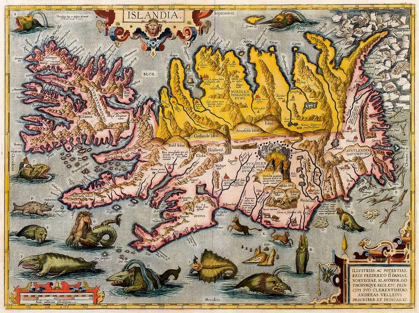
Bishop Gudbrandur Þorláksson's map of Iceland 1590: The version by Abraham Ortelius.
In 1590 Abraham Ortelius published a new supplement, Additamentum IV, to his collection of maps, Theatrum orbis terrarum. Amongst the new maps is a map of Iceland (Islandia). The author is not mentioned but on it says that it was engraved in the year 1585. On it we can also find a dedication to Frederick II of Denmark by Andreas Velleius (Andreas Sørensen Vedel); a well-known Danish historian of the period. It has been known for a long time that Vedel is not the author of the map and he could not have made it. The map is so superior to all earlier maps of Iceland in content and execution that an Icelander must be its originator. All clues point in the direction of Gudbrandur Thorláksson, bishop of Hólar. In his school days in Copenhagen he had studied mathematics and astronomy alongside theology. He had calculated the position of Hólar and arrived at an amazingly accurate result. He made a map of the North in 1606. The map of Iceland by bishop Gudbrandur does no longer exist and it is not known when he made it or what resources he had at his disposal. A list of churches and fiords has been found which he seems to have used, especially the latter, which he follows very closely for a large part of the coast.
Ortelius seems to have received the map directly from Vedel's own hands, and probably it never occurred to him that Vedel was not the author. At about this time, Vedel was writing a history of Denmark, which in fact never appeared, which was to be accompanied by maps. Nothing is known of any contact between Vedel and the bishop, but it is not unreasonable to suppose that Vedel should have turned directly to the bishop for assistance in this respect, it was customary at this time to supplement historical writings with geographical introduction and explanatory maps. Some of the information that Ortelius gives about Iceland on the back of his map is taken directly from Vedel.
Ortelius' map of Iceland was for a long time attributed to Vedel, although even in the time of bishop Gudbrandur it was known that he was not the author. A contemporary of the bishop, the Danish historian Lyschander, attributes the map to the bishop without further comment, and the same applies to bishop Finnur Jónsson in his Ecclesiastical History.
On his map Ortelius does not follow the calculations that bishop Gudbrandur had made on the latitude and longitude of the see at Hólar. It is not known when Gudbrandur completed his calculations, it may be after he handed over the map.
The ocean is provided with a large number of whales and monsters, which can hardly have accompanied the original. They, along with polar bears, driftwood and sea ice, are marked with the letters A-Q which refer to explanations on the back of the map. Some of the information regarding these creatures may have come originally from Iceland, perhaps from bishop Gudbrandur by way of Vedel, who is given as authority for some of it. This would then have been added to and mixed with foreign fables and inflations. Most of the pictures can be traced originally to Olaus Magnus, though the immediate source is more probably Sebastian Münster, who adopted many of the former's drawings in his Kosmographia (1544); with minor changes. It is not out of the question that some such drawings may have accompanied bishop Gudbrandur's map, since he was a most accomplished draughtsman. In the text on the map itself there are various accounts which can probably be traced chiefly to Icelandic tales and superstitions, whether or not they were to be found on the bishop's own map.
The map has roughly 250 names, many of them rather distorted, though not so much as to be unrecognisable. In many cases they are given a Danish form, but there is no way of knowing whether this is the work of the Danish intermediary or whether the bishop himself made the changes for the convenience of his Danish readers. Some forms clearly represent misreadings of the bishop's handwriting, arising from his use of insular letter forms, which was long in the custom in Iceland though quite unknown elsewhere at this time.
Although the map is faulty in many ways, it is far superior to all earlier maps of Iceland in content and execution. Here for the first time we find a map giving a more or less complete survey of all settlements in the country and most places of interest. Apart from this the most striking thing is how angular the country is, with very prominent headlands. The south and east coasts are far too straight instead of being curved. The width is too great in relation to the length, a tendency which continued to plague maps of Iceland for a long time. The country is also placed too far north. The central highlands are extremely poorly represented, amazingly little being known about them then and indeed much later. Most of the principal glaciers, however, are marked on the map, though Vatnajökull, the largest glacier in Europe is missing.
Bishop Gudbrandur's map of Iceland in the version by Abraham Ortelius was printed without change from the same plates in every subsequent edition of the book in various languages after 1590, until publishing was discontinued in 1612. In Latin 1591, 1592, [1595], 1601, 1603, 1608 and 1612; French 1598; Dutch 1598; German 1602; Spanish 1606 and 1612; English 1606; and Italian 1608 and 1612. It is often difficult to see from what edition of the collection a particular map is. Most copies of the map that exist have been taken from editions of the book which have been torn up and the maps sold as individual sheets. Many copies have been coloured.
The term of the old maps as represented in Carta marina by Olaus Magnus was now over, and most cartographers took bishop Gudbrandur's map as their starting point. Ortelius was first on the spot, forcing others to follow him.
Map and info courtesy of
kort.bok.hi.is


