
|
|
Area/Range |
|---|---|
|
|
33.80476°N / 106.89078°W |
|
|
4538 ft / 1383 m |
|
|
Overview

Established in 1941, the Bosque del Apache (Spanish for "Woods of the Apache") National Wildlife Refuge (NWR) comprises 57,191 acres along the Rio Grande at the northern edge of the Chihuahuan Desert in southern New Mexico. It is part of a system of 548 such refuges in the United States. The landscape of this refuge is diverse, ranging from the low-lying floodplain of the Rio Grande to the arid foothills and mesas of the Chupadera Mountains to the west and the San Pascual Mountains to the east. Elevations range from about 4,500 feet at the Rio Grande to 6,272 feet at the summit of Chupadera Peak. Wetlands account for about 13,000 acres of the refuge. Bosque del Apache, which means “Woods of the Apache,” is home to more than 340 species of birds as well as other wildlife such as the mule deer, coyote, porcupine, and muskrat. The NWR is managed by the U.S. Fish & Wildlife Service.
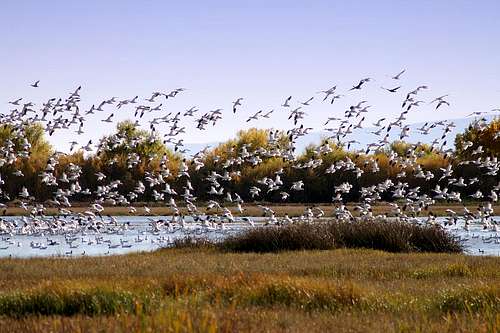
Riparian habitat dominates the lower-level region. There are natural permanent wetlands that lie to the west of the Rio Grande that provide excellent year-round opportunities for wildlife viewing. The biggest attractions at the NWR are the daily mass flights of as many as 50,000 snow geese and 17,000 sandhill cranes in the winter months. At sunrise, they ascend from the wetlands and fly to the grain fields to the north to feed all day. Then at sunset, they lift off from the grain fields and return south to the wetlands to spend the night, safe from predators. This occurs daily like clockwork from about mid-November through mid-February.
Wildlife viewing can be done entirely by driving the 15-mile auto loop. This is a one-way loop with a dividing two-way connector that runs across the center of the loop. The route takes you by the marshes, grain fields, and seven observation decks situated around the refuge for wildlife viewing. Four of the seven observation decks have wheelchair access.

Page under construction - please check back for updates.
Getting There
From the north: From Interstate 25, take exit 139 at San Antonio (south of Socorro); proceed south of Hwy 1 for about 8 miles. The visitor center will be on your right, and just past it is the vehicle tour route to the left.From the south: From Interstate 25, take exit 124 at San Marcial; proceed north on Hwy 1 for about 9 miles. The visitor center will be on your left and the vehicle tour route will be on the right just before the visitor center.

Hiking & Camping
The table below summarizes the hiking trails in the NWR.| Trail | Length | Hiking | Biking |
|---|---|---|---|
| Canyon Trail Loop | 2.5 miles | Yes | No |
| Chupadera Trail | 9.7 miles round trip | Yes | No |
| Lagoon Trail | <0.5 miles | Yes | No |
| Marsh Overlook Trail | 3.0 miles round trip | Yes | No |
| Rio Viejo Trail | 2.0 miles loop | Yes | Yes |
The Chupadera Trail leads to the summit of Chupadera Peak (6,272 feet), which transferred from private ownership to the NWR in May 2007.
Camping is not available to the general public. Primitive camping is restricted to educational and volunteer groups on a reservation basis only.