
|
|
Canyon |
|---|---|
|
|
18.84099°N / 97.18952°W |
|
|
Hiking, Canyoneering |
|
|
Spring, Winter |
|
|
Overview
 View of the canyon after the first river crossing.
 Hilos de Plata waterfall seen from the end of the trail.
The Cañón de la Carbonera lies within the Parque Nacional Cañón de Rio Blanco, in the central Mexican state of Veracruz and is considered to be one of the most beautiful natural areas of the state. The canyon is about 8.5 km long and 200m to 750m deep. It was created by the Río La Carbonera which finds its origin at Pico de Orizaba. A total of 24 waterfalls, 12 natural springs and 4 caves have been recorded and beside its nice scenery, Cañón de la Carbonera offers the visitor a couple of option for outdoor adventures.
You can hike into the canyon from Nogales (the most popular way to visit the canyon) or you can canyoneer the whole canyon top down, starting from the village Palo Grande. To do the latter a couple of outdoor companies in Orizaba offer their services. You’ll start at 2150m and end at 1295m over a total of 8.5km which could be done in a long day, or you could camp in the canyon and make it into a day and a half. It’s rated 3BRV. Ask at the Orizaba Tourism office at the town hall (also called the ‘Palacio de Hierro’) about agencies if you want to go canyoneering.
If you are hiking into the canyon from Nogales, you will hike the Río Carbonera upstream for about two to two and a half hours to an 80m high waterfall called ‘Hilos de Plata’ (or ‘Golden threads’). The name refers to the waterdrops falling down while the sun shining through them which makes it look like golden threads falling down the edge of the canyon. Below, in section three, the description on how to get to the waterfall.
Getting There
 The trail.
 Río Carbonera.
If you are coming from Mexico City or Puebla and drive to Orizaba on Highway 150 you will first reach Ciudad Mendoza, then Nogales and then Orizaba. So you could get off the bus or park your car in Nogales somewhere near the church or drive to the neigbourhood of ‘La Carbonera’ at the entrance of the canyon.
You’ll see the church and town hall of Nogales on your left side from the highway. Cuidad Mendoza and Nogales nowadays are kind of suburbs of Orizaba, so it takes only some 15min (8km) from Orizaba to Nogales by bus (6 pesos).
Hilos de Plata waterfall trail
 Río Carbonera at the bottom of the canyon.
 Río de Carbonera at the bottom of the canyon.
 Sign to the waterfall.
 Hilos de Plata waterfall.
When you are facing the church of Nogales, take the street that goes left in front of it, after about 100m turn right into Calle Martires 14 de Abril. From here go straight untill the little bridge. After the bridge the road becomes a dirt road. It turns left a bit, but then goes right, into the canyon. This is the neighbourhood of ‘La Carbonera’.
After about 5min following the Río Carbonera (on your right side) you’ll see a hanging bridge across the river. 50m further ahead, the road goes goes down towards the river. I guess this could be called the beginning of the trail. To get here from the church of Nogales should be about half an hour. If you don’t go down towards the river here, the road continues past a couple of houses turns into a trail that also goes towards the river.
If you cross the river right after the bridge a broad trail continues and you see a sign saying ‘hilos de plata’ on a tree on your right side after some ten minutes. Another ten minutes further, you’ll walk past a farm. From here on the trail becomes more narrow and goes through the valley with lush vegetation. There is a second sign at about one hour from the trailhead indicating the way to waterfall. From here the trail goes towards the river again.
You’ll cross a side river of Río Carbonera (it was dry when I crossed it in December) and after about 15min you’ll have to cross the river again. There are plenty of big rocks in the river so it shouldn’t be too hard and you shouldn’t get wet. If you cross here, some twenty meters on the other side of the river the trail goes up and goes all the way straight to the waterfall in about 30 min. If the water would be to high at the second crossing of the river, you might lose the trail on the other side, so even if you get wet, cross the river at the point where the trail takes you.
From here, as you are walking above the river, you’ll see the waterfall from a distance. At its foot big boulders create smaller waterfalls. When I was there in December, the waterfall wasn’t that big. Like its name says, it was more like waterdrops (but then many of them) falling down into the canyon, so there wasn’t really a pool at the bottom. You can continue a little bit from here.
If you continue upstream, walk under the waterfall and climbing over some boulders you’ll reach the actual end of the trail in some 15 min. A big boulder with a flat vertical side marks the end, together with a cross with a photo of the ‘Angel de la Guardia’ (Angel of the Guardians). Next to the big boulder, the Río Carbonera comes down pretty steep over the rocky surface of the canyon. You can go up a little bit to a little plateau where three more crosses have been put in place. But from here on it’s impossible to continue without taking big risks. There is another waterfall around the corner which is actually the Río Carbonera falling down a steep wall.
Red tape and camping, when to go
There are no restrictions concerning camping in the canyon and I've seen a few spots where you could actually pitch your tent. However if you are just doing the hike to Hilos de Plata it is rather uncommon to also camp in the canyon. You'll find the best options to spent the night in Orizaba.
For canyoneering, the rainy season is best avoided. So the best months would be in winter and spring, roughly November to March, which is are also the best months of the year for climbing in the area. It will still get pretty hot during the day, and you should still except clouds to come in around noon. So if you are just hiking into the canyon, you could go any time of the year.
Other things to do while in the area
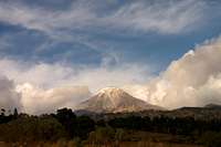 Pico de Orizaba.
 Sierra Negra and Pico de Orizaba from Atitzintla.
The whole area around Orizaba has plenty of moutains, hills, river and caves to go to.
When it comes to mountains, Pico de Orizaba is at 5636m the most interesting and challenging (and highest of Mexico) to climb. Most people approach from Tlachichuca, to reach the summit via the Jamapa glacier. The Southern approach is closer to Orizaba, but harder to climb because there is no glacier. The nearest hotel is in Esperanza, about 1 hour west from Orizaba, from where you could reach the basecamp (Gonzalez Gomar hut) in half a day. Next to it, lies Sierra Negra, at 4680m also an interesting hike.
The best rock climbing of Veracruz is to be found only ten minutes from Orizaba at 'la Pared de Santa Catarina' (the wall of Santa Catarina), and has 24 rockclimbing routes. For info and gear contact one of the outdoor agencies in Orizaba.