Toggle navigation
Mountains
Routes
Images
Trip Reports
Forum
What's New
People
Areas & Ranges
Articles
Trailheads
Canyons
Huts & Campgrounds
Albums
Logistical Centers
Fact Sheets
Lists
Custom Objects
Gear
Plans & Partners
WELCOME TO SUMMITPOST
SIGN IN
REGISTER
Queen Mine Route
Additional Parents
Image
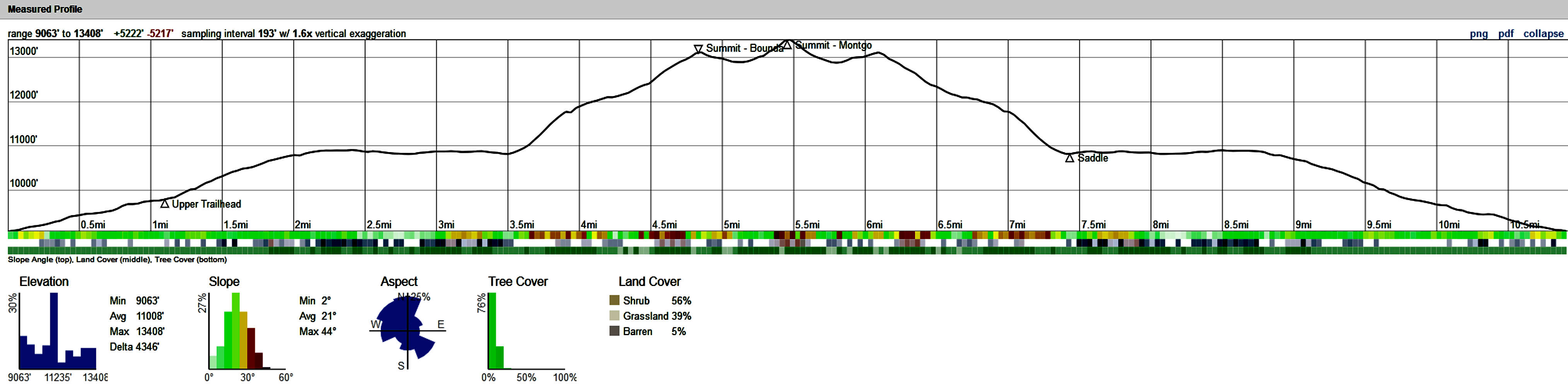
Caltopo Profile for both peaks from Queens Mine
View High-Resolution Image
Caltopo Profile for both peaks from Queens Mine
This is a Caltopo generated profile for Boundary and Montgomery Peak via Queens Mine.
« PREV
NEXT »
cshanek
on
Jul 12, 2018 1:00 pm
Comments & voting
Other parents
Lat/Lon:
37.84610°N / 118.35°W
Image ID:
1020379
1242 Hits
0
% Score
0
Votes
Log in to vote
Comments
No comments posted yet.
to post!
Don't have an account?
Queen Mine Route
(Route)
You are at
the First
Image
Viewing
#1 of 1
GALLERY
You are at
the Last
Image
cshanek's Image Gallery
« PREV
Viewing
#18 of 42
GALLERY
NEXT »
×
You need to login in order to vote!
User Name
Password
Remember me
Forgot your password?
Log me out when I close my browser.
Keep me logged in all the time.
sign in as a user
Don't have an account?
Register now for FREE
Rating available
Suggested routes for you
People who climb the same things as you
Comments Available
Create Albums
Register Here


