
-
 6056 Hits
-
 71.06% Score
-
 1 Votes
|
|
Route |
|---|---|
|
|
19.75309°S / 68.69948°W |
|
|
Expedition |
|
|
PD |
|
|
Overview
 Cerro Nevado from Bella Vista
No one was able to tell us if the summit is really à 6000 or not. Someone working in the mine at the entry of the walley (where you have to register), told us 6040m. Our GPS gave us 6014 and accurate satellite calculations set the altitude of the summit at 5974.
The region and the mine is owned by a society set in La Paz with offices in Uyuni too. You don't need to visit them to climb the mountain, but when you entry the mine region you will have to register. Miners are really friendly and will not ask for money for the climb. You can let a tip if you want.
Listen carefully to their indications.
Getting There
The best way to get there is to start with a Jeep in Huyuni, cross the salar, take some time to visit the Hotel de sal and to stop in the middle. Hotel de Sal
Yyou even can sleep next to Isla Inchuasi (WGS84 decimal coordinates -19.840836,-68.245783) rising in the middle of the salt lake.
 Isla Incahuasi
when you cross the salar you should get a little town called Llica: Geographical coordinates in decimal degrees (WGS84)
Latitude : -19.850
Longitude : -68.250
From there ask for the right route for Bella Vista (at the entry of Llica there is a control point of the bolivian army, they know the route and will be able to help you).
When you get to Bella Vista(19.807812,-68.278828)you will see the school at then entry of the village, there is a little football court in front of it. cross in front of the school and follow the route climbing up in the middle of tea and tapioca plantations. after some 30-40 minutes you will reach the mine where you have to register.
 Sulphur mine (registration)
The route goes on after the mine but you will have to evaluate the ground conditions, with snow or ice it's quite impossible to go on with the car, consider 3 walking days from here to reache the summit if you don't need to acclimatize.(we left our Jeep there and followed the route by walking to its end).
 Car part from Uyuni to the sulphur mine
Route Description
From the end of the route you will easily understand the climbing line up on the ridge to reach a first little summit.From there you will have to go down around 200 meters and then climb up again to the saddle. From here you climb south and north summit.
 Cerro Nevado map
The route is really easy but the slope is enough to cause dangerous avalanches. Moreover, you are on the highest ridge of the region, separating Bolivia from Chile. Wind may be really strong up there and nights are really cold and dry!
 Ridge
RidgeEven if the path is quite easy, don’t underestimate it, we heard about accidents occurred to guided tours in the past.
 Cerro Nevado summit
Essential Gear
As for each summit of the Andes, it's recommended to use good and complete climbing gears including down jacket and gloves, storm-proof tent and warm sleeping bag (almost -20°C). Sun glasses are a must-have but take a pair of goggles with you in case of storm.You don’t need specific technical gear, but you will need crampons, ice-axe and a little rope to ensure that no one flies down the slope in case of strong storms.
Sticks may be helpfull.
Tips and triks
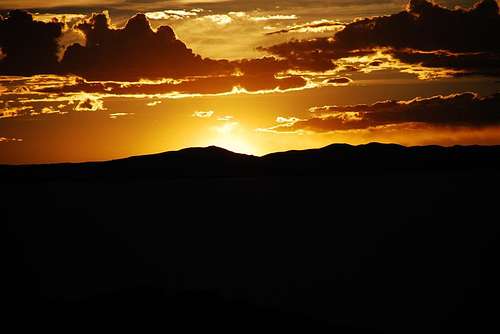
The view from the summit is incredible: we suggest you climb up to the saddle between the two summits the first day very early in the morning so you will have time to set up your camp there.During sunny days, in the evening, you may climb to the lowest summit (north summit - 1h) and from there you will see the sun going down on the Pacific Ocean (the Chilean coast is only 50 km far).
The following morning start very early (3.30-4 AM) and get to the main summit. You will enjoy a breath taking sunrise on Salar de Huyuni and Laguna Coipasa.
Don’t drink water coming from the mountain; it contains sulphur which will result in stomach problems. Prefer melted snow to prepare tea and soups. Try to drink almost 3-4 litres per day to avoid high altitude disease.
MAPS
Google Earth interactive mapLet me know if you need maps, we did some documentation and scans we will share with everyone for free!