
|
|
Mountain/Rock |
|---|---|
|
|
20.12520°N / 98.4234°W |
|
|
9416 ft / 2870 m |
|
|
Overview
El Parque Nacional de Chico Hidalgo is a little gem nestled in the hills above the town of Pachuca, about 1.5 hours north of Mexico City. It isn’t one mountain as it is a series of rocky spires, promontories and bluffs that occur all through the park, not simply in one section. There are numerous places to visit if you wish to boulder, rock climb or rappel.
The bluffs and spires range anywhere in height from 5-250m so one can have their fill of all types of climbing within the confines of one relatively small area.
The park is 2470Ha and was originally set aside in June of 1982 in recognition of its unique geological and environmental diversity. Chico Hidalgo is located in the hills above Pachuca only a short 20km up winding roads to the park’s entrance. The park is home to a variety of animals including: falcons, eagles, deer, coyote, mountain lions raccoons and armadillos.
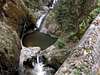
Chico Hidalgo is also a popular spot to simply get away from hustle and bustle of the city. There are numerous spots to camp, the sites are clean with washrooms nearby and the skies open up at night and provide a canopy of stars that needs to be seen to be believed. There all also numerous waterfalls to be seen throughout the park, both big and small.
For the most part the rock is good but there are numerous knobs that stick out and I would be reluctant to trust much weight on these, as a number broke off when I tested them. Stick to the more common ridges and cracks; they are what you can trust in
 |  |  |  |
Climbing Areas- Las Ventanas
These are only three of over a dozen unique and amazing climbing areas the park has. So this is intended to give you just a taste of what can be found in Chico Hidalgo. Hopefully others with more knowledge can provide info. on some of the other areas, and I will fill in holes as I return.
Las Ventanas- 2959m
This is the most popular area for climbing and when you see it for the first time it is clearly obvious why. Spires, gendarmes, boulders and cliffs rise from the forested floor making for a near heavenly rocky playground. This is where rock climbers flock to every weekend to escape the rigors of city life. Las Ventanas means ‘the windows’ and is a small enclosed area where all the climbing is essentially at your fingertips.
Bolted routes are plentiful with routes ranging from one to five pitches and ranging in difficulty from 5.9 to 5.11 and up. There are virtually anywhere from 50 or more different pinnacles, spires, boulders and cliffs to choose from… enough for years and years of climbing. Unfortunately at this time this area of the park is closed to the public. Only climbers who have joined specific climbing clubs or who have special permission are allowed access. Apparently this section of the park is privately owned and the gov’t wasn’t respecting their proprietary rights, so the owners got pissed off and closed the area to the public. Which of course leaves climbers and trekker’s out in the cold… good thing that the park is chock full of alternate climbing spots.
 |  |  |
Climbing Areas- Pena del Cuervo
Pena del Cuervo- 2800m
This is a singular cliff that rises 75m above the valley floor and dominates much of the central section of the park. Pena del Cuervo means ‘cliff of the crow’ and like the Ventanas is a popular area for climbers and rappelers.
At the top is a lookout which is open to the public. It is only a five minute hike from the parking lot, and the views out over the valley and of other bluffs nearby is magnificent. The Pena though is a singular cliff and while there are a number of routes to the top it has nowhere near the variety of routes, venues and landscapes that you can find at Las Ventanas or around Cruz Grande and El Corazon.
 |  |  |
Climbing Areas- Cruz Grande
Cruz Grande and El Corazon- 2870m
Meaning literally the ‘big cross’ and ‘the heart’ this is a much larger area than the Ventanas as it is more spread out… but the climbing opportunities in and around this section are perhaps even more varied than what one would find at the Ventanas. One simply has to work harder to get to the base of some of the rock towers and cliff bases.
While I have visited all three of these areas this is the section of the park I know the best and the one with perhaps the best uninterrupted views for kilometers around. From the top of the whale’s back you can see down to the town of Mineral de Chico far below. Also the rock formations are beautiful to behold and this is a prime vantage point indeed.
Like Las Ventanas there are dozens of places where one could climb. Unlike Las Ventanas many of the areas are not bolted and are thus only suitable for bouldering, rapping or free climbing. The largest and most popular cliffs have bolted routes including one of the largest cliff faces in the park a 150m high slab that lies 1.5 km to the northwest.
Just 2 minutes off the road lies a huge upthrust rock (reminiscent in shape to Ayer’s Rock). It is about 45m at its highest point and again offers plenty of places to boulder. To the north across a deep ravine are the twin spires of Cruz Grande which jut 65m up from the forest floor. These are the pinnacles that give this section of the park its name. From the top of the whale’s back (which is what I will call this huge wall of rock) you can see all of the nearby climbing areas, dozens of towers and cliffs to satisfy even the pickiest or rock climbers. To gain access to the whale’s back; there is a class IV route where one can free climb 20m or so to the relative safety of the top. The other option is to walk around to the far end of the whale’s back and follow the road to where it drops down to the forest, there is class II access there, but it is long walk and a lot of work bushwhacking. The first access point is right at the front left corner of the whale’s back… it can easily be seen when one surveys the rock for routes to the top.
On the top of the whales back are a plethora of gullies and small boulders or ridges with many spots to boulder or free climb. Most of it is class III-IV only but is a lot of fun nonetheless. I spent an afternoon simply climbing and exploring and after three hours there was still plenty left to see and do. This is what makes Chico such an extraordinary place as it is somewhere you can keep coming back to for years and you will always be filled with wonder at what you see and do.
 |  |  |  |
Getting There
To get to Chico Hidalgo from Mexico City take highway 130 north towards the city of Pachuca for about 90 minutes (a distance of 175km). From Pachuca take the 105 towards Pachuquilla (a suburb) until you start to the signs for the zona turistica. The exit for Chico Hidalgo is a narrow road on the right hand side.
From there you will climb steadily into the hills, eventually leaving behind the arid semi desert and entering the lush pine and oyamete forests of the park. From here you simply follow the road around for about 25km (stopping along the way if you wish at Las Ventanas) to the pueblo of Mineral de Chico. Here you can purchase a map and ask locals how to get around in the park.
You could also probably get information while at Las Ventanas without driving into Mineral, but in Mineral you will be able to pick up a map which will greatly aid you in being able to navigate the park, as the roads aren’t as straightforward as the map portrays them. It is more than a little easy to get turned around.
After you pick up the map pick a spot and be prepared to spend some time getting to know only a few areas... it takes days just to get a feel for the park and just to get your bearings.
 |  |  |
Red Tape
There are no set fees to pay and no permits required to camp near or climb in the park. There are camp sites located in a few specific locations and for only 35 pesos a night you get a clean site with toilets and running water.
When To Climb
Like all of Mexico’s mountainous regions the best time to climb is during the dry season from November to march, this is weather you can set your watch to. The rest of the year is hit or miss. The first time I went up the whole region was swathed in clouds and it rained on and off all day. Yet this is Mexico and it will only rain so much. There really is no month where one couldn’t find a day to head up to Chico and enjoy a day or half days worth of climbing. Simply look for a window in the weather and run with it.
 |  |
Camping
As previously mentioned there are a couple official spots to camp, with the largest and most popular being close to Mineral de Chico. If this doesn’t interest you however and you want somewhere more isolated or serene, one need only remember that this is Mexico and no one is going to get bent out of shape if you pitch a tent just about anywhere. Just be clean and respectful, pack out what you pack in and there should be no complaints whatsoever.
It costs around 35 pesos a night to camp in the designated areas, and if you prefer to leave your tent at home they will erect one for you and rent it to you for an additional 25 pesos per night… which is clearly a steal
 |
Mountain Conditions
The best way to check the weather is to go to www.xpmexico .com or you could check www.mapsofmexico.com and click on weather information for Pachuca and that should give you relatively accurate details and a good idea of what to expect when you climb.
You can also check www.cnn.com/WEATHER and check their forecasts for Pachuca and the Mexico City area.
I would also suggest getting an early start the clouds start to move in around mid day and freak thunderstorms are common. Also simply to see Chico when the skies are clear, there is really nothing like it. Chico is also an area that is known to be very foggy so again make sure you know the weather before you head in so that you aren’t disappointed with how things turn out and become disheartened