


-
 3396 Hits
-
 80.49% Score
-
 12 Votes
|
|
Route |
|---|---|
|
|
45.66900°N / 7.38696°E |
|
|
Hiking |
|
|
Summer, Fall |
|
|
A long day |
|
|
(EE/F+) Easy for Expert Hikers |
|
|
Note
|
La montagna chiama i suoi figli, ed essi rispondono fedelmente al suo appello… Osvaldo Cardellina, Diario alpinistico, 1964-65 Page texts: @ OsvaldoCardellina "Osva", passed away on May 2, 2022. Page owners: Christian Cardellina e Osvaldo Cardellina. Any updates from September 12, 2022: Antonio Giani, page administrator, friend and climbing companion. Testi della pagina: @ OsvaldoCardellina "Osva", scomparso il 2 maggio 2022. Proprietari pagina: Christian Cardellina e Osvaldo Cardellina. Eventuali aggiornamenti dal 12 settembre 2022: Antonio Giani, amministratore della pagina, amico e compagno di salite. |
Overview
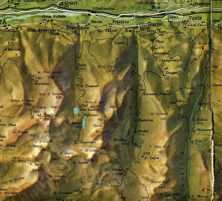
This hill has never been very fashionable and thus poorly attended even in the past. Located at the Northeastern extremity of valley of the same name between the Eastern Punta Rossa (3.400m) and Monte Emilius (3.559m), connecting the same with that of the Vallon Laures above Grand Brissogne Common. Among them exists, but moved further North, a second pass known as the Passo dei Tre Cappuccini (3.342m). This is definitely the most popular, not so much for the crossing between two valleys but for the ascent along the Normal Route to the Monte Emilius or South-southeast Crest. The Col d'Arbole however, rarely achieved for the ascent to Punta Rossa via the Northeast Ridge, is the transit route between them. In truth it also this sparsely populated and frequented by hikers in the second half of 1800 in transit from Les Laures to Arbolle and back in the Seventies 1900 where he met a certain popularity in the Ski-Mountaineering. In fact, if we peer into Bobba & Vaccarone Guidebook 1896, we find into the 108/9 pages only the description of the way between Brissogne Commune and Aosta Town and with a picturesque tone that entice you to a beautiful hiking crossing between the two: "From Brissogne by the way of the hill Leppe (p. 107, where it is described in the opposite direction) up the valley Laures to the great lake of the same name; then continue for that of the Laures pass (p. 35) along the Lac Long and Lac Dessous; thither leaving on the left the path of Laures pass, continue west and brecciai and a small glacier can be reached without difficulty the step that opens the first depression to the north of punta de Laures (the second in the south of Mount Æmilius ) - 6 hours ". Descends for a short scree on the glacier Arbole, slightly tilted, the moraines and the shores of Lake Arbole - m. 2.961. - from which a poor track between continuous stony ground go through the valley to the west; drops some bands, passes under the slope landslide of whom cometh the way the Pas du Valaisan and down at the feet of the one from which falls the way of the Pass of Garin, until came to the elbow that the valley is coming from the west to the north as the pastures of Arbole at the shores of the lake - m. 2.490. - Below these the valley bursts into a great wall of steep cliffs; three gullies plow it, and falls trail to the right-most, east, making a little rough. At the foot of the giant bastion are the green pastures of the picturesque Comboé plateau. - For the continuation, (p. 110)." Ancient routes for walking "robust" that require excellent hocks and a will of steel; paths that the construction of the existing asphalt roads and farm tracks were confined to the upper parts removing sections of the lower middle hill. For these reasons, we want to offer this fascinating itinerary again. At least between Pila Resort and Les Laures ...
Questo colle non é mai stato molto di moda e quindi scarsamente frequentato anche nel passato. Situato all'estremità Nordorientale dell'omonimo vallone tra la Punta Rossa Orientale (3.400 m) ed il Monte Emilius (3.559 m), collega il Vallone medesimo con quello delle Laures sovra il Comune di Grand Brissogne. Tra questi esiste, ma spostato più a Settentrione, un secondo passaggio conosciuto come il Passo dei Tre Cappuccini (3.342 m); questo risulta sicuramente più frequentato, non tanto per l'attraversamento tra i due valloni bensì per la salita lungo la Via Normale al Monte Emilius o Cresta Sud-sudest. Il Col d'Arbole invece, raggiunto raramente per la salita alla Punta Rossa tramite la Cresta Nordest, costituisce la via di transito tra i medesimi. Per la verità anch'essa scarsamente popolare e frequentata dagli Escursionisti nella seconda metà del 1800 in transito da Les Laures ad Arbolle e viceversa negli Anni Settanta del 1900 dove ha conosciuto una certa popolarità nello Sci-Alpinismo. Infatti, se andiam scrutare in Guida B&V 1896, troviamo alle pagine 108/9 esclusivamente la descrizione della via tra Brissogne ed Aosta con un tono pittoresco tal da invogliare ad una bella traversata escursionistica tra le due: "Da Brissogne per la via del colle di Leppe (p. 107, ove é descritta in senso inverso) si risale il vallone delle Laures fino al gran lago omonimo; quindi si continua per quella del colle di Laures (p. 35) lungo il Lac Long fino al Lac Dessous; colà giunti lasciando sulla sinistra il cammino del colle di Laures, si prosegue verso ovest e per brecciai ed un piccolo ghiacciaio si raggiunge senza difficoltà il passo che s'apre alla prima depressione a nord della punta de Laures (la seconda a sud del Monte AEmilius) - ore 6 ". Discendesi per un breve macereto sul ghiacciaio d'Arbole, lievemente inclinato, alle morene e alle sponde del Lago d'Arbole - m. 2.961 - da cui un misero viottolo fra continui sasseti percorre il vallone verso ovest; cala alcuni scaglioni, passa sotto il pendio franoso da cui discende la via del Pas du Valaisan e più giù ai piedi di quello da cui cala la via del Passo di Garin, finché giunta al gomito che il vallone fa volgendo da ovest a nord tocca i casolari d'Arbole sulle rive del lago omonimo - m. 2.490. - Sotto di questi il vallone prorompe in una gran parete di rupi scoscesa; tre canaloni la solcano, e il sentiero cala per quello più a destra, est, facendosi un pò scabroso. Ai piedi di quel gigantesco bastione stanno i pascoli verdeggianti del pittoresco pianoro di Comboé. - Per la prosecuzione, (p. 110)." Vie antiche per passeggiate "robuste" richiedenti ottimi garretti e volontà d'acciaio; percorsi che la costruzione delle attuali strade in asfalto e poderali hanno circoscritto alle parti superiori eliminando i tratti della medio-bassa collina. Proprio per questi motivi vogliamo proporre nuovamente questo affascinante itinerario. Almeno tra Pila e Les Laures ...
Getting There
By car:
- From TORINO, MILANO, etc: Motorway A5. Exit at IVREA or Quincinetto (PIEDMONT).
- From IVREA Town: in West towards Pont Saint Martin, Donnas, Bard, Pontey, Fénis, Saint Marcel, Grand Brissogne, Pollein, Charvensod, Gressan Municipalities.
- From Courmayeur Resort: in East towards Pré St. Didier, Morgex, La Salle, Saint Pierre, Sarre, Aosta, Gressan, Charvensod, Pollein and Grand Brissogne Municipalities.
- From Grand Brissogne (827m) to L'Arp, dirt road, Les Laures Vallon-Ernesto Ménabreaz Shelter (2.546m) at Lower Laures Lake (2.544m), path-muletrack. From Charvensod to Dard-Comboé-Arbolle Vallons towards Ponteilles (1.697m) Alp/Waterfall, through dirt road, Comboé Alp/Saint Ours Shelter (2.114m), through dirt road, and Arbolle Refuge (2.516m), near Lakes (2.497m), by Chair Lift to Chamolé Station (2.309m), Lake (2.325m) and muletrack. From Charvensod (main road from Pont Suaz 567m) or from Gressan, nearby the Municipality, with alternative Regional Road towards Pila-Resort.
Route Description
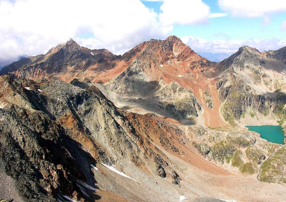
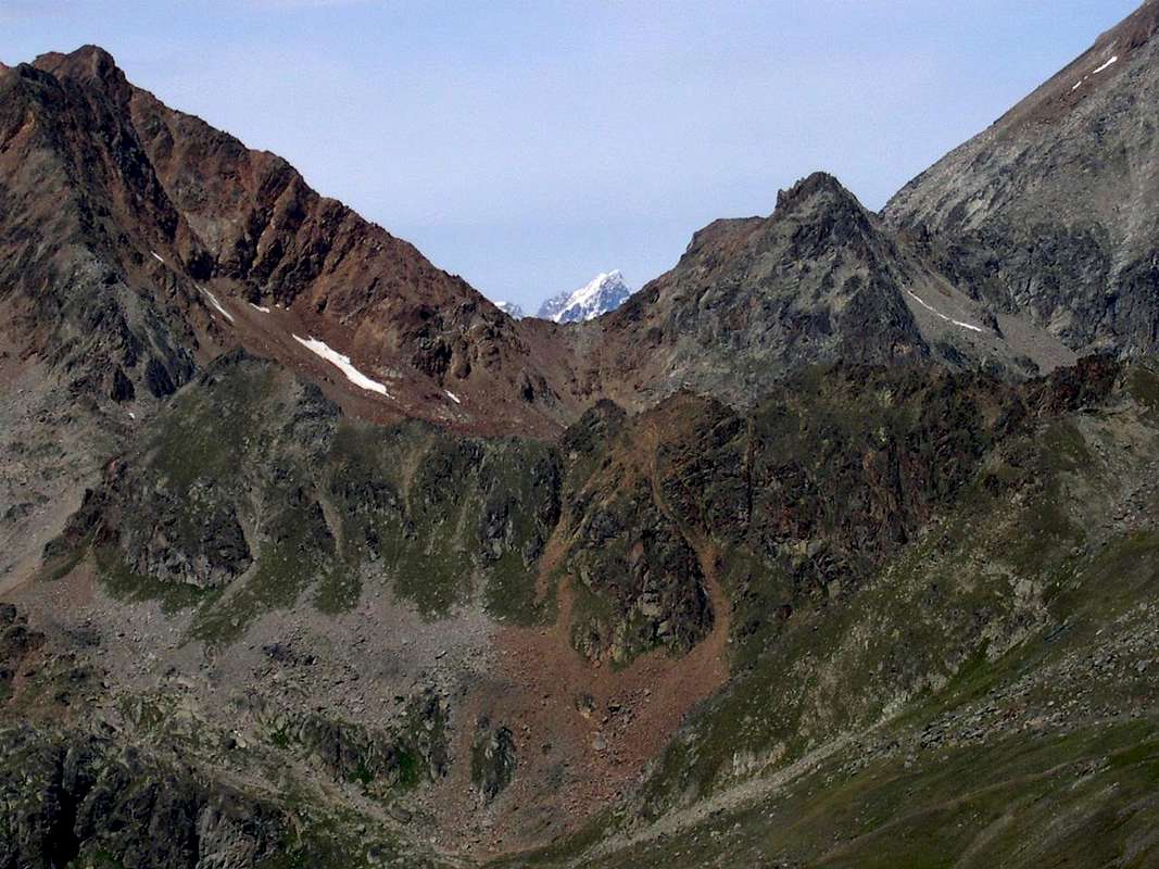
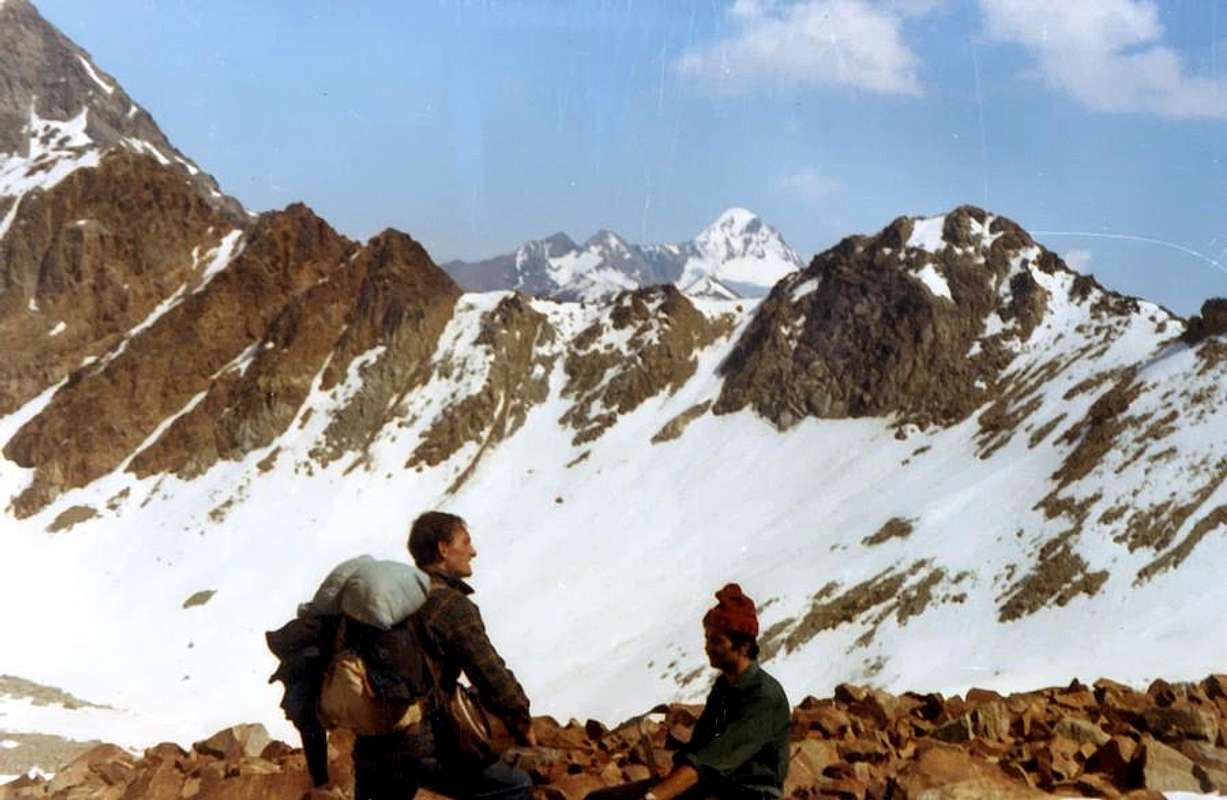
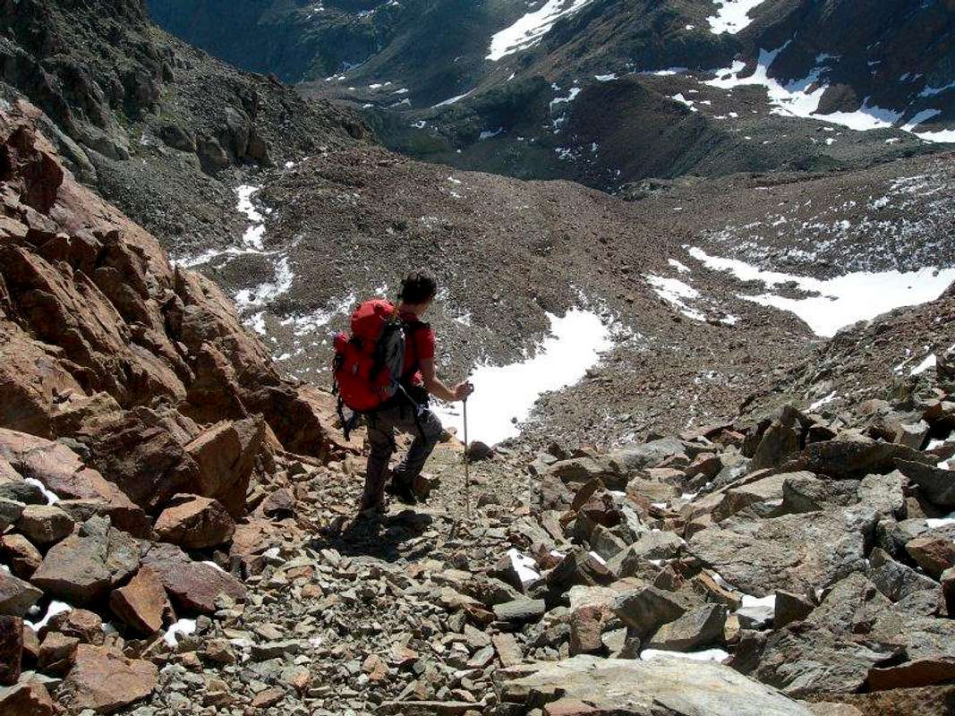
A) - By Pila through Arbolle Vallon: from Pila (known ski resort, reachable by bus from Aosta car or cable car), arrive at Lake Chamolé (2.311m; here by chairlift or on foot), by means of various paths n° 19A/19B/19C etc. and the upper hill of the same name (2.641m), for which it goes down convenient to Alpe di Arbole (2.510m) through the path-mule track n° 14/18/TVC. Head East to Lake Gelato (2.956m) with the path n° 14, from which rise in the direction of no longer snowy Northern Face of Emilius's Punta Rossa, via a small trace into a moraine. The ascent route arrives on the nearby Colle di Arbole (3.154m; EE/F+; 2h'45 from refuge; 5h'15/5h'30 Pila).
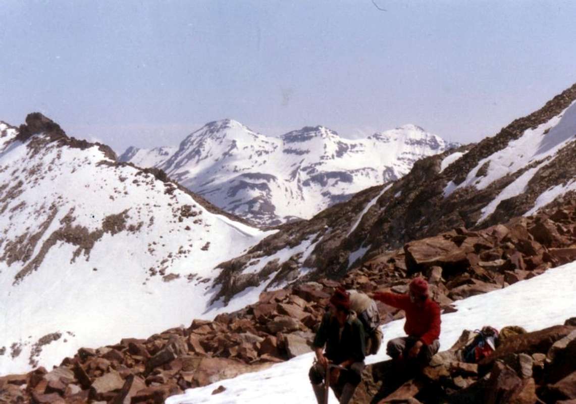
B) - Starting from Grand Brissogne-Primaz (894m):, go along the road till the Gremonenche Alp (1.000m). From here along the dirt road up to l'Arp (1.310m) at the end of the same; then, along a path n° 1 that, bordering the stream (Des Laures Torrent), leads to La Vieille (1.623m) and to Le Tramail or Tramouail (1.951m; intermediate pasture for cows, good shelter when weather is bad, always open). Crossing some small wooden bridges up to the altitude around 2.200 meters, (starting from this point a steep but faster path goes, at right (West), toward the slopes of Becca di Seneva. Better go on toward East forwarding the Becca di Salè (called Black Fountains) and climb the last 400 meters on wide slopes till the top of the great rocky terraces (2.600m) (here a small chapel dedicated to two brothers "Dino" and Jean Charrey and Cino Norat dead in 1929 on the East Wall of Monte Emilius). A short descent leads to the Refuge Ernesto Mènabreaz, partisan by Nazi-Fascist execution firing squad (2.542m, private); the refuge has an open free part (with covers, wood-burning stove and provisioning) usable as winter room (8 places), on the Eastern bank of Laures Lower Lake. From here toward South getting, after a short step in East of with the same name alp, the of Laures Long Lake (2.630m). Walk all along the Western bank always on the same path n° 4 that fast becomes a track turning toward the lower part of the morenal tableland in quota 2.763 meters, near Montet Torrent. Go up toward fork 2.933 meters, nearby a mini-tiny lake; leaving in left (East) the path to Leppe Pass, continue by winding route amongst great blocks, rubbles, debris towards the Laures Pass (3.036m). Also abandon this path and, addressing himself more to the West-northwest in a valley below the Punta Rossa, via a steep gully earthy reach the hill (2h'30 from shelter).
|
|
|
A) - Da Pila per il Vallone d'Arbole: da Pila (nota località sciistica, raggiungibile da Aosta in auto pullman o funivia), pervenire al Lago di Chamolé (2.311 m; anche qui in seggiovia o a piedi), per mezzo di sentieri vari n° 19A/19B/19C ecc. e l'omonimo colle superiore (2.641 m), per il quale si scende al comodo Rifugio d'Arbole (2.510 m) tramite il sentiero-mulattiera n° 14/18/TVC. Dirigersi verso Est fino al Lago Gelato (2.956 m) con il sentiero n° 14, donde salire in direzione dell'ormai non più nevosa Parete Nord della Punta Rossa, tramite piccola traccia nella morena. L'itinerario di salita raggiunge infine il vicino Col d'Arbole (3.154 m; EE/F+; 5h'15/5h'30 da Pila).
B)- Da Gran Brissogne-Primaz (894 m): salire lungo la strada poderale verso l'Alpe di Gremonenche (1.000 m) trovando il cartello di divieto presso il Villaggio di Luin. Da qui sempre per mezzo della medesima raggiungere l'Alpe di L'Arp (1.310 m) al termine della stessa); poi, con il sentiero n° 1 fiancheggiante il Torrent des Laures, le successive di La Vieille (1.623 m) e di Tramail o Tramouail (pascolo intermedio per le mucche; ottimo ricovero in caso di cattivo tempo; sempre aperto; 1.951 m). Attraversando alcuni ponticelli in legno, raggiungere la quota di circa 2.200 metri (partendo da questo punto si snoda verso destra (Ovest) in direzione delle pareti della Becca di Seneva un sentiero più ripido ma anche più veloce nel prender dislivello). Migliore è la salita però portandosi ad Oriente contro la Becca di Salé (cosiddetta Via delle Fontane Nere) risalendo gli ultimi 400 metri su larghi pendii adducenti a grandii terrazzamenti rocciosi (2.600 m; piccola Cappella dedicata ai due fratelli Alessandro "Dino" e Jean Charrey ed a Cino Norat, caduti nel 1929 sulla Est dell'Emilius). Una piccola discesa porta al Rifugio Ernesto Ménabreaz, intitolato al partigiano fucilato dai nazi/fascisti (2.542 m; privato ma con un locale sempre aperto per gli alpinisti e attrezzato con 8 posti letto, coperte, stufa a legna e vettovagliamento), posizionato sulla sponda orientale del Lac Dessous des Laures. Da questi progredendo vero Sud con un sentierino, oltrepassando a sinistra dell'omonima alpe, raggiungere il Lago Lungo (2.630 m) e, continuando sulla sua sponda Occidentale, lasciando a Sudest sotto la Cresta Sudovest della Grande Roise la via che conduce al Colle di Leppe, sempre tramite sentiero n° 4 raggiungere verso Sud-sudovest la spianata morenica a quota 2.763 metri, vicino al Torrent Montet. Quando si tramuta in traccia, risalire al bivio 2.933 metri, presso un minuscolo laghetto; lasciando ad Est la via al Colle di Leppe continuare con percorso sinuoso tra grandi blocchi, frantumi e detriti verso il Col des Laures (3.036 m). Abbandonare anche questa e, indirizzandosi ad Ovest-nordovest in un valloncello sotto la Punta Rossa, con ripido canalino terroso raggiungere il colle (2h'30 dal rifugio).
Essential Gear
DIFFICULTIES From F to F+ for both the routes described above.
Dal F al F+ per entrambe le vie descritte.

EQUIPMENT For High Hiking, better if with crampons in Western side.
Da Alto Escursionismo, meglio se con ramponi sul lato Occidentale.
Campings
Remember that free camping is forbidden (except for emergency reasons, over 2.500m, from darkness until dawn).Mountain Condition
- Meteo: you can find all the needed informations at the official site of the Valle d'Aosta Region:
- Valle d'Aosta Meteo
Books and Maps
- "Guida del Monte Emilius", di Osvaldo Cardellina Editore in collaborazione con il Club Alpino Italiano Sezione di Aosta, Dicembre 1978.
- "Guida dei Monti d'Italia – Emilius Rosa dei Banchi Parco del Mont Avic" di Giulio Berutto e Lino Fornelli - Club Alpino Italiano/Touring Club Italiano, Marzo 2005.
- "Guida delle Alpi Occidentali" di Giovanni Bobba e Luigi Vaccarone C.A.I. Sezione di Torino Volume II (parte II), 25 Maggio 1896.
- "80 itinerari di Escursionismo Alpinismo e Sci Alpinismo in Valle d'Aosta", di Osvaldo Cardellina, Ed. Musumeci, Giugno 1977 (in Italian); seconda Ed. Luglio 1981; terza Ed. Luglio 1984; (in French), prima Ed. Febbraio 1978; seconda Ed. Marzo 1980.
- "Diari Alpinistici" di Osvaldo Cardellina e Indice Generale accompagnato da Schedario Relazioni Ascensioni 1964-2019 (inediti).
 |
 |
 |
- Kompass "Gran Paradiso Valle d'Aosta Sentieri e Rifugi" Carta turistica 1:50.000.
- L'Escursionista "Conca di Aosta-Pila-Monte Emilius" Carta dei sentieri (n° 4) 1:25.000.
- Hapax "Les Sentiers Comunità Montana Monte Emilius", Luglio 2000 1:25.000.
- Enrico Editore Ivrea-Aosta "Gruppo del Gran Paradiso" 1:50.000.
- I.G.C. Istituto Geografico Centrale, Torino "Carta delle Passeggiate ed Escursioni in V.D.A. Conca di Pila-Gressan, 1:20.000.
Important Information
- REGIONE AUTONOMA VALLE D'AOSTA the official site.
- FONDAZIONE MONTAGNA SICURA Villa Cameron, località Villard de la Palud n° 1 Courmayeur (AO) Tel: 39 0165 897602 - Fax: 39 0165 897647.
- A.I.NE.VA. (Associazione Interregionale Neve e Valanghe).
Useful numbers
- Protezione Civile Valdostana località Aeroporto n° 7/A Saint Christophe (Ao) Tel. 0165-238222.
- Bollettino Valanghe Tel. 0165-776300.
- Bollettino Meteo Tel. 0165-44113.
- Unità Operativa di Soccorso Sanitario Tel. 118.