
|
|
Custom Object |
|---|---|
|
|
49.39227°N / 20.10575°E |
|
|
construction site |
Stoh
|
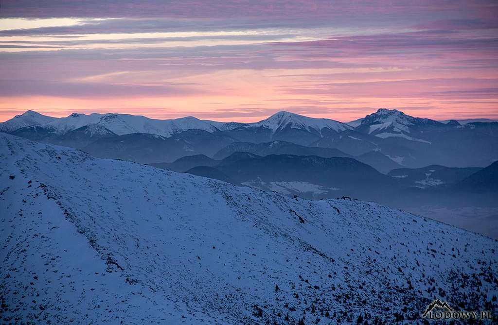
xxx Stoh means Haystack and is aptly named. It sits on the main ridge just south of Veľký Rozsutec, separated from it by sedlo Medziholie (sedlo = saddle). It is three metres shy of its famed neighbour and nowhere near as jagged as it, however, a prominence of 380m makes Stoh the third most prominent summit in the Malá Fatra range. Stoh's charm lies in its regular, conical shape and the challenge the mundane, at first steep and slippery, ascents from the saddles lying north of the summit (especially from Stohové sedlo), present. Those northerly routes as well as the summit command beautiful views of Veľký Rozsutec. Among other interesting peaks and areas pretty well seen from the summit, I would name Veľký Kriváň and Malý Kriváň, the Veľká Fatra range and Veľký Choč.
|
Overview
|
The main ridge of the Krivánska Malá Fatra (or just the Krivánska Fatra) range runs more or less southwest to northeast from the antecedent gorge of the River Váh to Zázrivka brook. At either end of the mountains the main ridge line is far from obvious. Especially the northeast corner of the mountains is interesting in this regard. Veľký Rozsutec, regarded as the most beautiful Slovak mountain outside the Tatras, is believed to sit on the main ridge. And the same goes for Malý Rozsutec although the red main ridge trail skirts it. However, if you take a closer look at the topography and geology of the area, you will see that the Malá Fatra range extends beyond Zázrivka brook, which makes me think that in fact its main ridge from the pass of Medziholie runs east over Osnica (1363m) and Ostre (1167m) towards Hrčova Kečka at 1226m on the east side of Zázrivka (and road 583). 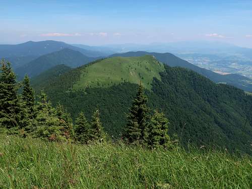
Anyway, the chunk of the mountains east of Zázrivka brook, where Hrčova Kečka reigns (I would call it Oravská Malá Fatra), has no waymarked trails (all of the Malá Fatra is a national park in which you are obliged to stick to designated paths) and does not attract hikers. To sum up, this page deals with the red main ridge trail plus Malý Rozsutec. The trail can be hiked in two days with the night spent at a mountain hut called Chata pod Chlebom. Another hut you can stay at is Chata pod Suchým near the west end of the trail. I will describe the route starting at the Krivánska Fatra’s southwest end, where my hike began in June 2024. Route statistics Distance: 34*-36km Total elevation gain: about 3,000m Walking time: 15-16h * without descending to Chata pod Chlebom Elevations given in the text according to M. Kalaš & J. Kicko. Vyskum a ochrana Malej Fatry, pp. 82–92, 2017 |
Nezbudská Lúčka – Chata pod Suchým
|
Distance: 7km Total elevation gain: 720m Walking time: 3-3.5hrs 
The eastern TH, where I started my hike, is in the quiet village of Nezbudská Lúčka, whose main street is lined with traditional houses. On the other side of the Váh, on a rock roughly a hundred metres above the river perches the ruin of Strečno Castle. 
Between the footbridge over the river and the nearby ferry crossing the trail leaves the main street turning left to cross the railway. Gaining some elevation, the road passes the last house and runs through some meadows. Soon it reaches the forest edge, where our trail turns into a narrow path running along it. You return to the river for a short while, then at a rest point 2.5km from the train stop at Nezbudská Lúčka-Strečno (at 358m), you leave the Váh for good and start walking up along its tributary called Hradský potok. The name means Castle Brook, which signals that you can expect to see another old castle shortly. Before you get close to the ruin, you will see it from a distance. It will show up ahead of you once, popping out of the overwhelming woodland. 
A couple of minutes after the road passes a spring named ‘Dobrá voda’, i.e. Good water, there is a trail T-junction known as Podhradské (434m). The road, from that point blazed with blue marks, carries on straight up Hradský potok in an easterly direction, towards Chata pod Suchým, the first mountain hut along your way. But the red marks denoting the main ridge trail turn right and angle back up the slope of the ridge dividing Hradský potok from the Váh, leading you to the ruins of Starý hrad (Old Castle), which was built in the 13th century, about a hundred years before Strečno Castle. 
The Old Castle, which is being slowly restored, sits at roughly 475m, 3.5km from the trailhead. It is an atmospheric place offering picturesque views of the River Váh and the wooded hills which surround it. 

At the castle the red marks resume their former easterly direction and head for Chata pod Suchým up the ridgeline which is the southern boundary of the catchment area of Hradský potok. (It is not actually part of the Krivánska Fatra’s main ridge, which forms the off-trail northern boundary of the catchment area of Hradský potok.) The ridge for you to follow is pleasant, fairly narrow, in places one metre wide, dropping abruptly to the Váh. 
After a few hundred metres you have a spectacular view of the shapely Domašínsky Meander. The only minus is that some noise from the highway running along the river is continually heard. 
Past that viewpoint the ridge widens and continues rising until the summit of Plešel at 981m, after which, some 1.5km from Chata pod Suchým, the ridge nearly levels out and the path turns into a track. For the first time Suchý and jagged Biele skaly come into view. 
If you start your hike early in the morning you can have breakfast in Chata pod Suchým at 1066m. I started mine at 5 pm when my train arrived at Nezbudská Lúčka, so I stayed for the night in my tent pitched by the hut and had breakfast in the hut the next morning. It was the last week before the summer holidays so I was alone at the camping spot located a hundred metres west of the hut. There is a spring right in front of the hut, where I filled my bottles. Telling by the notice in the toilet, the hut suffers from a shortage of water in high season. 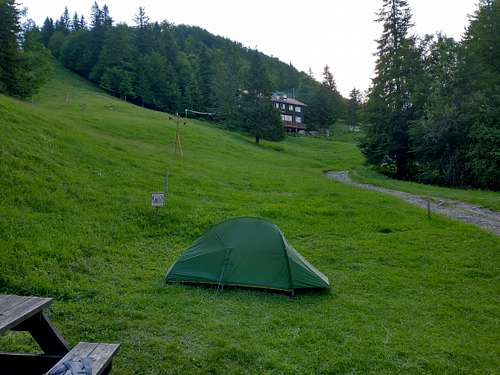
|
Chata pod Suchým – Chata pod Chlebom
|
Distance: 12km Total elevation gain: 1,000m Walking time: 5.5hrs From Chata pod Suchým (1066m) the red marks climb the adjacent steep slope rapidly to soon reach the main ridge at a clearing named Javorina (1147m), which gives a fantastic view of your nearest future: part of the main ridge between Suchý (1467m) and Stratenec (1509m) with the jagged Biele skaly (1471m) in between. From Javorina it is a little more than one kilometre to Prislop pod Suchým at 1219m, where the red ridge trail intersects with the yellow marks that traverse both sides of Suchý and Biele skaly, which lets the lazy or those in a hurry to skirt these peaks. Although the trails are marked it is easy to unintentionally find oneself on the wrong path (yellow marks) near here because the parting spot is not signed. The red marks go on straight up the ridge to the summit of Suchý which rises almost 250m above Prislop. 

The summit of Suchý, which – like many Slovak mountains – has a two-barred cross as its marker, commands panoramic views, the most captivating being the view of the further section of the main ridge crowned with Malý Kriváň at 1668m. The first stretch of this section, called Biele skaly (White Rocks), is very attractive. The rough path goes up and down winding across a sea of evergreen shrubs dotted with white calcareous rocks. There are a few YDS class 2, occasionally even 3 if you avoid using the artificial aids, scrambling sections, without much exposure though. Some today’s maps read that the elevation of Biele Skaly is less than 1450m, the summit marker claims it is 1462m, but careful measurements carried out in the late 2010s (please see References) determined it to be 1471m. 
At the northeast end of Biele Skaly is sedlo Vráta at 1436m. Here the ridge trail is joined by the northern branch of the yellow marks you crossed at Prislop pod Suchým. About 350m north of the saddle is the summit of Stratenec at 1509m, where you have the first view of Veľký Rozsutec peeking from behind the green ridges of the central part of the mountain range. You descend to sedlo Prehyb at 1452m, where the other branch of the yellow marks comes from the south (and at which some blue marks arrive from the northwest). From this saddle it is 1.3km and 215m of ascent to the summit of Malý Kriváň. When you get to the old and ugly concrete Malý Kriváň’s summit marker, you have covered a distance of 12.5km from the trailhead, with a total elevation gain of over 1400m. 
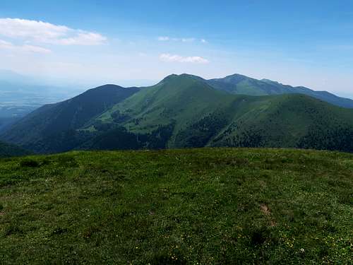
Malý Kriváň at 1668m is the second highest peak of the Malá Fatra. It is a bit more frequented than the peaks you have climbed so far, but far less frequented than Veľký Kriváň at 1708m, which sits roughly 2.5km east of it. The views are panoramic: several mountain ranges surrounding the Krivánska Fatra, most of its main ridge including the peaks you have already summited, Veľký Kriváň, Chleb at 1647m to its right, and to its left Stoh at 1607m, Veľký Rozsutec at 1610m and Malý Rozsutec at 1343m. 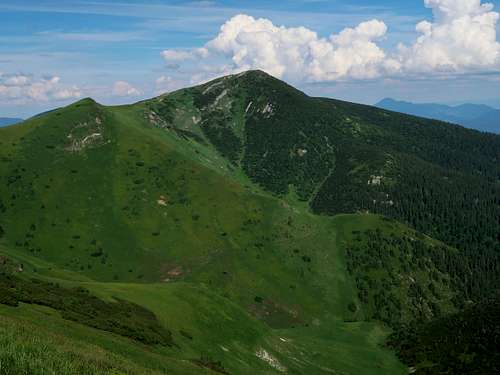
Past the summit of Malý Kriváň the main ridge rather gently descends to a nameless saddle at roughly 1440m, beyond which sits Koniarky at 1535m. This portion of the trail, especially at the beginning, is pleasant and fairly rugged. Our red marks do not summit Koniarky but traverse its south side. 
Here lies one of the key springs for the hike, but bear in mind it can run dry in the summer. 
The red trail returns to the crest of the main ridge at sedlo Bublen some 400m east of Koniarky’s summit (where you can legally get via green marks if you think that makes sense). From Bublen you continue gaining elevation through grassland patched with dwarf pine. On your left you have a fine view of both Rozsutecs and the green cone of Stoh. 
When you have passed Pekelník at 1610m, the summit of Veľký Kriváň is less than a half-hour walk up away. At 1641m is a T-junction from which a dead-end path, or rather a broad track worn by countless feet coming mostly from the nearby cable car station, leads to the summit of Veľký Kriváň. Not surprisingly, the panorama from the summit is similar to that from Malý Kriváň except that the imposing massif of Malý Kriváň is an important part of it. 
From Veľký Kriváň you descend to Snilovské sedlo (1524m), just north of which sits the upper station of the cable car. You can leave the ridge trail at the saddle switching to green marks (in winter you leave the crest half a kilometre later on). A mile down the road (good views of the east face of Veľký Kriváň) and you are at Chata pod Chlebom (1423m) – you have covered a distance of nearly 20km from the trailhead, with a total elevation gain exceeding 1700m. Chata pod Chlebom, completely remodelled in 2021, sits half a mile south of the summit of Chleb. The hut seems to be maintained to a very high standard. In June 2024 I pitched my tent by the hut, which cost me 10 euros, and I was absolutely amazed by its luxurious, immaculate showers. Breakfast was served from 7am, dinner until 9pm. Plenty of water was available, there was nothing to complain about whatsoever. |
Chata pod Chlebom – Biely Potok (Terchová)
|
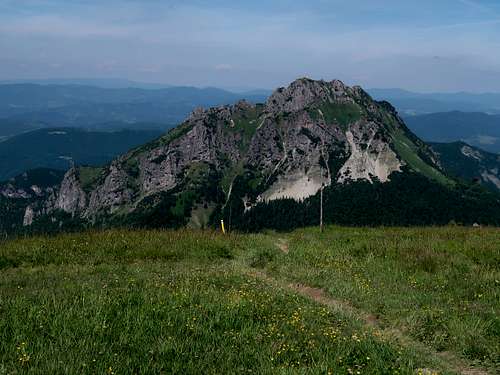
Distance: over 17km Total elevation gain: nearly 1,300m Walking time: about 7hrs From Chata pod Chlebom you can get back to the main ridge via the yellow marks, but this would mean you were not interested in summiting Chleb. I was, so I backtracked up the road linking the hut with Snilovské sedlo. Halfway along the road a path, also blazed green, branches off angling towards the crest, which is reached about 600m west of Chleb’s summit. Standing on the summit of Chleb, I was pleased I hadn't left it out, despite traffic getting heavier as people keep coming from the cable car. Chleb at 1647m commands fine views and looks interesting itself from Hromové (1636m), the next summit on the ridge. Past Hromové the grassy ridge turns north. This section is called Steny (Walls) although it is not dramatic as its name would suggest. After the north summit of Steny the main ridge turns east again. The views of Veľký Rozsutec are getting better and better. On your right conical Stoh (Haystack) at 1607m dominates the scene. 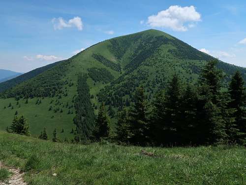
After Stohové sedlo (1232m) another distinct section begins. 85m up and you are at a T-junction named ‘Chrbát Stohu’. From here you can traverse the north side of Stoh almost horizontally (yellow marks) or you can make another ascent by climbing the pyramid. The latter means 290 vertical metres up, the most arduous being the section through the forest, which actually began at Stohové sedlo. 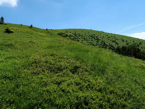
The slope is steep and there is no rock under your feet but clay, or rather mud. Trekking poles are indispensable here. I remember falling over twice while fighting the wet ground along this stretch without poles several years ago, and it was on my way up, not down! What is pleasing about this stretch of the trail is that the trees offer you shade when the sun is hot. If you have risen to the challenge of summiting Stoh, you should feel some satisfaction though. Another benefit is spectacular views of Stoh’s neighbour, Veľký Rozsutec. The descent to sedlo Medziholie (1185m) is gentler but is also very muddy later on and it lasts longer than the half-hour suggested by some maps. 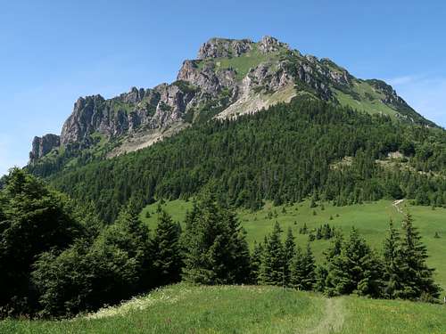
More photos taken from the main ridge trail between ‘Chrbát Stohu’ and Medziholie are to be found on the Stoh page. According to the maps there should be a few sources of drinking water near Medziholie. In fact only the spring by the trail to sedlo Osnice (the southern branch of the blue marks) is worth checking out. However, bear in mind it may run dry like most of the springs near the main ridge. An ascent of Veľký Rozsutec from Medziholie means 425m of elevation gain and lasts about 1.5 hours. There are a few sections of YDS class 2 scrambling, all of them chain-assisted, and a few iron ladders, far from vertical though. Vistas from above the tree line, including the summit area of course, are fabulous, I would say the best of all in the Malá Fatra. 


East of the summit of Veľký Rozsutec is a signposted junction, or rather intersection of paths, from which a dead-end trail takes you to the summit in a few minutes. In the opposite direction the designated path runs towards Malý Rozsutec, following the crest of the mountain. 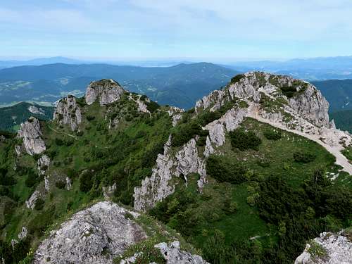
Be careful here as it is easy to stray onto a seemingly obvious well-worn path traversing the east side of Veľký Rozsutec, which later on (especially its lower branch) is being overgrown by dwarf pine in places. (The unmarked paths join the red marks after some 300m.) The red trail will lead you to a pass called Medzirozsutce (1203m), which separates the massif of Veľký Rozsutec from that of Malý Rozsutec, whose solitary rock shows off half a kilometre away. 
About 150m west of sedlo Medzirozsutce is a spring: follow the blue marks west, then turn right onto a well-trodden path. I filled my bottles here, but the spring didn’t look 100% safe to me, so I decided to make use of my water purification tablets. From Medzirozsutce, in ten minutes, you get to sedlo Zákres (1229m), where I parted with the red main ridge trail, which turns right here to head for the village of Zázrivá. Malý Rozsutec lies off the main ridge, just west of Zákres, but offers interesting scrambling on both its east and west faces, so to me it was something I couldn’t miss. The following description of the last stretch of the route, from Zákres saddle to Biely Potok, has been copied from Malý Rozsutec page (more photographs there): 
At the very base of the rock pyramid marking is misleading: do not turn left at the metal stake with the trail mark (now we are on a green trail), but walk straight on up the broad path. A steep narrow ramp in the east wall of Malý Rozsutec allows hikers to scale the cliff. Without using the artificial aids (cable and chains) the scramble is YDS class 3. Getting from Zákres to the summit takes less than 20 minutes. Views from the summit are similar to those from Veľký Rozsutec except the southerly view, which is of the north face of that great massif. 
The green trail descends down the west face of Malý Rozsutec via a chute full of regolith, slope stabilization devices as well as artificial climbing aids without which the scrambling would be even more difficult than that on the opposite side of the mountain. Below the highest rope-assisted section, situated just below the top of the mountain, there are a few more so altogether there is more scrambling here than on the east face. 
When you get into the forest, the path is still steep, often muddy and slippery, so trekking poles are highly beneficial. About an hour after you started your descent, you reach a hamlet of Podrozsutec, from which you can carry on down the green trail to Biely Potok – Diery (hotel, inn, bus stop). There is a problem with the bus stop as the buses do not stop there (year 2024). That is why it may be better to leave the green marks half a kilometre past Podrozsutec (some 200m after the bend in the track) and turn right onto a road leading to a settlement known as Biely Potok – Solisko. 
|
Trails
|
xxx 
On the fringe of the Krivánska Fatra there are several access points you can choose from. Route statistics for the most likely options are in the following table.
And here is a short description of the stretch of the main ridge trail which runs over the summit of Stoh between a trail T-junction named ‘Chrbát Stohu’ (NW of the summit, 85 vertical metres above nearby Stohové sedlo) and sedlo Medziholie (NNE of the summit): From ‘Chrbát Stohu’ it is 290 metres of elevation gain to the summit. The most laborious is the first part of the ascent, through woodland. From Stohové sedlo the slope is steep and there is no rock under your feet but clay, or rather mud. Trekking poles are indispensable. I remember slipping and falling over twice while struggling to cope with the wet ground along this stretch without poles several years ago, and it was on my way up, not down! What is pleasing about this section of the trail is that the trees offer you shade when the sun is hot. Later on, above the timberline, the trail becomes less steep and on your left you have views of Veľký Rozsutec all the time.
An ascent from Medziholie is similar, generally gentler than from the northwest, but several hundred metres longer and with more elevation gain. 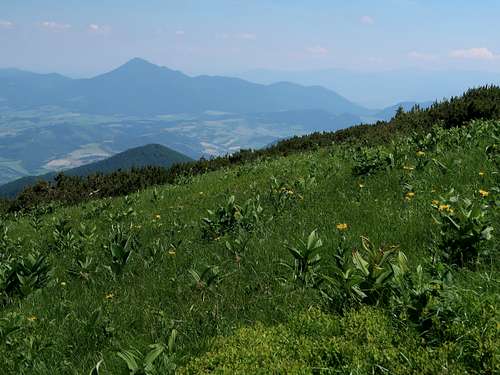
Apart from the main ridge trail (red marks) running over the summit of Stoh, ‘Chrbát Stohu’ and Medziholie are also linked by yellow marks which traverse the north side of the mountain almost horizontally. If it is wet expect tons of mud on this trail. 
If you are on the main ridge trail and wonder whether or not to climb Stoh, the following table might help you decide.
xxx
|
Maps
As for the analog maps, there are plenty of options. I would recommend the plastic 1:30,000 map by Compass. |
Getting There
|
At the southwest end of the route, just ten kilometres southeast of Žilina, one of the largest cities in Slovakia, lies the village of Nezbudská Lúčka. At the other end, about 25 km east of Žilina, is the village of Terchová with its hamlets such as Biely Potok. As far as public transport is concerned, the best way to get to Nezbudská Lúčka is by train, while Terchová is readily accessible by bus. |
Red Tape, Camping & Bears
xxx
|
When To Go, Mountain Conditions & Rescue
- To avoid the crowds, it is advisable to avoid weekends and go in late spring, September or October. If you are keen on a winter adventure, you will need the basic gear (crampons and ice-axe) and some experience.
- In Slovakia those who do not carry commercial insurance have to pay for any rescue services rendered by Mountain Rescue Service (HZS)
- HZS phone number: 18 300
- Mountain conditions on HZS site
- Weather forecast for Terchová on AccuWeather
- Weather forecast for the summit of Chleb on slovenske.sk
Red Tape
The area is part of a national park (or rather two parks: Karkonoski Park Narodowy in Poland and Krkonošský národní park in the Czech Republic. You are not allowed to camp/bivouac or stray from the waymarked trails. In Poland there is an entrance fee - an equivalent of approx. €2.00 for a day pass in 2024. In spring the trail between the summit and Okraj pass gets closed in order to protect the black grouse.

When To Climb & Mountain Conditions
- If you go in high season or at a weekend, there may be a crowd at the summit.
- Under winter conditions mini-crampons are advisable.
- Mountain rescue phone numbers: Czechia +420 1210, Poland +48 601100300
- Current mountain conditions in Polish
- Weather forecast for Luční hora on meteoblue.com
- Webcams
Red Tape
HikingYou must keep to the waymarked trails. Bivouacking is not permitted. You are not supposed to hike during the night. The trails above huts are closed for hikers from 1 November to 15 June. 
ClimbingYou must be a member of a rock climbing club. Just before your climb, you should write it into the register kept in a nearby mountain hut/your hotel. (Make sure you sign it on return too!) During the approach you must stick to the traditionally used routes described in rock climbing guidebooks. Bivouacking on the wall is only allowed in an emergency. Except for winter, you must not do a route that is easier than UIAA grade III (approx. YDS grade 5.3) unless on the descent. The funny thing is that the last rule does not apply to those hiking/scrambling with a licensed guide whom they have paid €200-300 for looking after them. 
|
Videos
VIDEO by LukZem
or
VIDEO by LukZem
or older version
Hăşmaş Mountains