

-
 8871 Hits
-
 85.87% Score
-
 21 Votes
|
|
Mountain/Rock |
|---|---|
|
|
48.49670°N / 120.62855°W |
|
|
Mountaineering, Scrambling, Skiing |
|
|
Spring, Summer, Fall |
|
|
7840 ft / 2390 m |
|
|
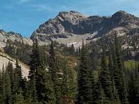
 East Face of Copper Point from Kangaroo Pass
 Setting from the north
Overview
 From the N - Spring
 From the N - Fall
Copper Point is the small peak located between Kangaroo Pass and Copper Pass and about 2 miles southeast of Washington Pass on Washington State Route 20. Its southern and western aspects are not impressive, but from the north and the east, it is an attractive little peak. There are Class 3 and 4 routes on its eastern and northern sides.
The peak was a surveying triangulation point and has a benchmark on the summit.
Getting There
 Access from hairpin
The shortest access is from the hairpin curve (large pullout – ample parking) to the east of Washington Pass.
There is a trail leading south from the hairpin curve to Kangaroo Pass, about 1.5 hours from the road to the pass. The East Face and North Ridge Routes are easily accessed from Kangaroo Pass. It is also possible to access the southwest slopes from here.
The first part of the trail consists of a lot of following small cairns across talus and boulders, but higher in the basin it turns into an excellent trail that is easy to follow and as good as many official, maintained trails.
To find the trail from the pullout, head toward the large talus slope just south of Spire Gulch. The trail skirts the bottom of this talus – watch for cairns and follow them carefully until you reach the upper part of the basin where the trail becomes very distinct.
The south and western side of the peak can also be accessed via the Copper Pass Trail. This is about 3.75 miles and 1,900 feet of elevation gain from the Bridge Creek Trialhead on Highway 20 via Copper Pass Trail 426.
Another trail description
Routes Overview
 From the west
West / Southwest Ridge From Copper Pass – Class 2 (there are apparently a couple of possibly Class 3 or 4 places that can be climbed if desired). The ridge can also be accessed via Class 3 rock from the north. (see TR - External Links)
 North Ridge
North Ridge – According to Beckey: "a 300-foot ascent (class 3) with minor loose rock".
From a trip report by SP member cp0915: "we were shocked by how steep and narrow, loose and exposed this "class 3" ridge was. Turns out, it was only class 4 but the exposed and loose crap was unnerving at times. We opted for a different way down..."
Full Report
Personal experience: I started to descend the route alone and turned back because of the steep loose rock – definitely more difficult than Class 3.
East Face – Class 3 if you are careful about route finding. Start in or near a couloir near the center of the face, then bear right over heather and talus to a rib leading to the summit. The rock next to the couloir could probably be climbed at Class 3 or 4 with better footing than in the couloir. I chose to climb the couloir because it was in the shade. I concur with Beckey's Class 3 rating – I also descended this route after backing off the descent of the North Ridge.
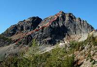 East Face with route marked East Face with route markedEnlarge for better detail |
 The upper East Face The upper East Face |
 The upper East Face The upper East Face |
Red Tape and General Forest Information
A Northwest Forest Pass is NOT required to park at the hairpin.South of Kangaroo Pass, you are in wilderness. If you plan to camp there, see the Okanogan National Forest web site for rules and regulations.
The Okanogan National Forest web site has current information regarding road and trail conditions, closures, campgrounds, etc.:
Okanogan National Forest
Camping
There are official USFS fee campgrounds on both sides of Washington Pass.The nearest is Lone Fir to the east with Klipchuck and Early Winters a bit further east, but at lower elevations and thus open earlier in the season.
Some folks "bivouac" at the Blue Lake Trailhead or even at the hairpin curve.
Beckey and others discourage camping in the basin above the hairpin for obvious environmental reasons.
Campground Information
External Links
Trip Report - access to West Ridge from the northTrip Report and photos of a ski ascent in early spring
 From Wallaby Peak