
|
|
Mountain/Rock |
|---|---|
|
|
34.56580°N / 112.0533°W |
|
|
Yavapai |
|
|
Spring, Fall, Winter |
|
|
6020 ft / 1835 m |
|
|
Overview
Crater Mountain is an easily accessible summit west of the I-17 between Prescott Valley and Camp Verde. It is centrally located on the way to Prescott, Jerome, Sedona, and Flagstaff, and makes for an easy mountain to grab if you have extra time when visiting those locations. It is located within the Black Hills of Prescott National Forest.
There are two potential starting points, the shortest less than 2 miles to the summit, with another option a little over 3.5 miles to the summit. A trail goes to within a half a mile of the summit, which can be easily reached going off-trail the remaining distance.
There are two parts to Crater Mountain. The main summit at 6,020’ and a lower summit ridge that tops out at 5,890’ with a prominence of about 240’ between it and the main summit.
For the longer route, Onion Mountain 5,725’ and Peak 5709 can be combined adding about 3 miles total, with a decent amount of off-trail hiking, but nothing too difficult.
Crater Mountain is an excellent destination if wanting to get away from the crowds. It is a little cooler than Phoenix, which means the window for hiking is longer. Because some off-trail is involved, hiking is recommended to begin in late October and go through early April to avoid the snakes.
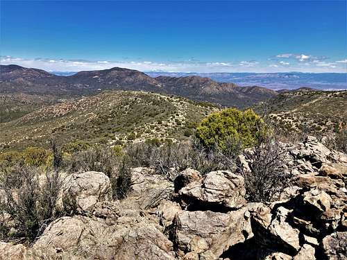
Summit views are excellent in all directions, with Humphreys Peak and the mountains of Prescott to the Mogollon Rim.
Getting There
There are two approaches. One goes straight up from northwest side, and the other starts from the southeast and heads up Crater Mountain East first, with access to Onion Mountain and Peak 5709.
For either starting point, if coming from I-17, take the exit for AZ State Route 169. Head west for 5.5 miles and turn right on W. Cherry Creek Road.
For the shortest approach from the northwest, continue north passing Powell Springs Campground and at 5.2 miles north of 169 there is a dirt road on the left. This is Federal Mine Road. There is parking on the right once you enter the road.
For the longer approach from the south that starts up Crater Mountain East, drive north for 1.3 miles to FR 96 and then head east for about 2.3 miles where the road splits. Find a parking spot along the side of the road. This is a good spot to park, because the road gets narrower at this point and there are gates ahead and washes. High clearance is recommended, although the road isn’t too bad.
Here are the coordinates: 34.547, -112.0425
Route
For the northwest approach. Cross over Cherry Creek Road and find a road going south. Head generally south towards the base of the ridge, descending slightly on the way. In less than half a mile, there is a trail leading up the ridge. There is a wide cut up the ridge that is obvious from a distance, so even if going off course, the way up is reached quickly.
The trail gains over 500’ in less than half a mile. At this point, it levels out. Continue on the trail for about a third of a mile, until the trail turns left towards Crater Mountain East. Get off the trail at this point and head straight up to the summit. It is only about 250’ of gain in about a half a mile. No major bushwhacking is required, and there are a few cairns here and there. However, it is pretty straight-forward.
The summit should be reached within about 1.8 miles, gaining less than 900’ in total. The entire hike can be done in less than two hours.
For the southern approach, start up the road on the left heading east. The road eventually turns north.
About 1 2/3rds miles from the starting point, the road passes by the base of the ridgeline up to Crater Mountain. There is a trail on the side. It isn’t signed, but there is an open spot along the ridge which clearly heads directly up the mountain.
The trail goes steeply up to the ridge gaining over 700’ in less than three-quarters of a mile. Towards the top, the trail fades out a little and you need to find you way up the ridge for the last 100 feet.
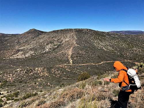
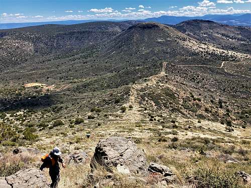
Once on the ridge top, the trail continues up slightly before descending to a saddle between the east ridge and the main summit ridge. The highpoint of the east ridge has a prominence of about 240’, and that summit is unmarked, but located just north of the trail when it plateaus.
Once at the saddle, the trail goes back up to the main ridge, but then curves to the right. As with the northern approach, head directly for the summit, which is easy to reach.
The summit should be reached within about 3 ¾ miles, gaining 1,380’ to the summit, and adding about 400’ on the way back. As noted above, Onion Mountain and Peak 5709 can be combined adding about 3 miles total.
Red Tape
There are no permits needed to hike up to Crater Mountain and no red tape. It is located within Prescott National Forest.