
|
|
Route |
|---|---|
|
|
37.22170°N / 112.9307°W |
|
|
Scramble |
|
|
Less than two hours |
|
|
class 4 (+) / rappel |
|
|
Approach
From the summit, head down either the direct or the indirect route until you come to the area where the drainage fork is.From the fork, follow the drainage to the left (north), bypassing the ramps (gullies) above and continuing westerly below them. If you're descending the non-direct route, simply continue westerly in the drainage from the bottom of the ramp (gully).
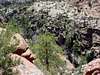
In a couple of hundred yards, the drainage will end at a series of cliffs above Pine Creek Canyon. Consider this the start of the descent variation.
Route Description
From the cliffs, you have a couple of options to make this outing a more enjoyable loop.1) rappel - Tree and/or boulder anchors are not terribly hard to find from the top of the cliffs above the canyon. Make sure you have enough rope to make the bottom and rappel down to the canyon floor. Near the west end of Peak 6275's west ridge, the cliffs are perhaps 200 feet high. As you hike along the rim toward the south, the cliffs tend to get a little lower - sometimes as low as 80-100 feet - though they're still plenty high in places. Multiple rappels are certainly doable in some places. Scope out your route before committing to it.
2) downclimb - If you look hard enough, class 4 downclimbable terrain is findable along the rim. Look for it and climb down.
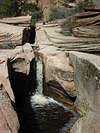
The exposure along the canyon rim is nice, the views are terrific, and the sound of rushing water below is pleasant. Once the canyon floor is reached, you will soon stumble across a very slick sandstone chute with Pine Creek rushing through it over two waterfalls. Good stuff.
The chute is bypassable on foot. Take a picture or two then follow the creek south until reach the highway 1/4 mile or so away.
For reference, the trailhead is to the east of where you come out on the highway from Pine Creek.
 |  |