
|
|
Mountain/Rock |
|---|---|
|
|
33.85410°N / 111.4956°W |
|
|
Maricopa |
|
|
Hiking |
|
|
Spring, Fall, Winter |
|
|
5120 ft / 1561 m |
|
|
Overview
Diamond Mountain is a prominent summit in the northeast corner of Maricopa County. Located on the west side of the Beeline Highway (87), it’s much higher than its neighbors to the south. As a result, views from the summit are pretty spectacular in all directions. It has a very accessible starting point, 300 yards off of the Beeline Highway, and the starting point is only about a 2 mile hike from the summit.
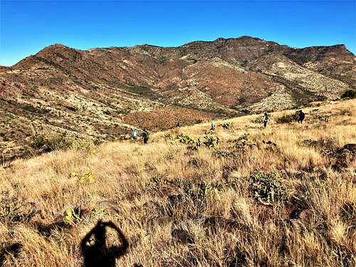
Diamond Mountain isn’t crowded. Because there is no trail leading all the way to the summit, you’ll likely be the only person on the mountain. Despite the short distance to the summit, the steep off-trail sections make this an advanced hike. Inexperienced hikers can easily get hurt by losing footing or getting into cactus or cat claw. There is some scrambling, although route finding isn't too difficult.
Hiking in summer is not recommended. The ideal times to hike Diamond Mountain are November, February, and March. Do not hike immediately after rain or snow due to the rocky terrain. Snow will hit the mountain at times in the winter due to its height above 5,000’.
Getting There
From the Phoenix metro area, take the Beeline Highway (87) for 28.6 miles from the junction between Shea Blvd and 87. There is a turn off on the left, which is easy to miss. Cross over 87 Southbound lanes and take a right on a forest service road that starts off paved and then turns to dirt. After 300 yards, there are a couple parking spots before the road turns back to the left. The turn off is seven miles past the Ballantine Trailhead. If you reach Sunflower, you’ve gone too far, but you can cross over the highway and go back southbound to the entrance in a couple minutes.
Once on the Forest Service Road, there are a few options for starting points, but the most direct is to park just 300 yards up the road.
Route
From the starting point, walk a tenth of a mile and turn right. Follow an old jeep track which deteriorates as you go further up. Eventually it becomes overgrown, and you just need to keep going up to the base of the mountain. After gaining about 400’ in half a mile, it is time to go steeply up the slope for the crux of the hike, gaining over 500 feet in less than a third of a mile. There are two rocky areas along this route. There is some Class III scrambling on both of them. These sections are short, with just a few moves to get back to hiking.
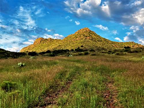
Once above the rocks, go left and hike along the ridge. It is brushy, but manageable. You reach the ridgetop, which continues up an obvious path towards Diamond Mountain. While this part is easy, the terrain gets steep once again, although not as much as the crux earlier in the hike. The final 450’ is steep with some rocky sections, but once past it, you get right to the summit. When we were there on March 5, 2022, there were two jars with crusty, old paper at the summit area. They weren’t obvious to find.
Hikers can descend back down the rocks along the crux, or down an adjacent ridge without rocky sections. For that descent route, go back to the edge of ridge above the crux of the hike, but don't cross back over above the rocks. Descend down from there, and continue until the terrain flattens out and you can cross back over towards the jeep track.
Depending on how you descend, the total round-trip hiking is between 4 miles and 4 ¼ miles, gaining over 1,550’. For the off-trail sections, brush is mild to moderate depending on the season. Generally, there are sufficient open areas to avoid the worst of it, and cactus is generally avoidable, while caution is required.
Red Tape
There is no red tape of note. The trailhead and the mountain are within Tonto National Forest.