
|
|
Mountain/Rock |
|---|---|
|
|
18.83203°N / 98.88805°E |
|
|
5528 ft / 1685 m |
|
|
Overview
Doi Pui (ดอยปุย) is the highpoint of the dominant mountain immediately west of Chiang Mai, Thailand, the country’s second largest city. The peak is in the far northwestern portion of the country in the Loi Lar Mountain Range which also contains Thailand’s highest peak, Doi Inthanon. The mountain is visible throughout the city and is best known for being the home of Wat Phra That Doi Suthep, a sacred temple situated just over halfway up the eastern slopes. The temple is named after the slightly lower southern summit and as a result the area is most commonly referred to as Doi Suthep. Note that many resources mistakenly report Doi Suthep as being only 9 meters lower than Doi Pui at 1676 meters, but Doi Suthep’s true elevation is closer to 1601 meters.Doi Pui is very accessible, with a long winding but well paved road reaching nearly to the summit. There are a couple of waterfalls and viewpoints along the way, and any trip to the peak should include a visit to Wat Phra That Doi Suthep, one of the most important temples in all of Thailand.


Getting There
 Road to Doi Pui
By motorbike or car:
The layout of Chiang Mai makes navigating to Doi Pui on your own a fairly easy task. Most tourists in the area will rent a motorbike locally after arriving which should cost 200-250 baht per day. A standard 100cc should be adequate for a solo trip, but with two on the bike a slightly more powerful 125cc is recommended and would be a bit faster. Car rentals are also available.
To drive to the summit first head to the northwest corner of the Old City, easily located due to the moat enclosing the area. Turn left to head west from here on Huai Kaeo Road (Route 1004), and follow it a total of 14.4 km to Wat Phra That Doi Suthep. Continue along the road another 5.9 km beyond the wat past Bhubing Palace and take a sharp right to head deeper into the park (after this sharp right the road becomes one lane, so drive slowly and beware of oncoming traffic). After a total of 24 km from the Old City you will reach the summit pullout for Doi Pui. That’s it.
By songthaew:
If uncomfortable taking a motorbike or car to Doi Pui, a songthaew (basically just a red truck converted so passengers can ride in the back) is an alternative. These are available for rides all over the city, but you will likely need to change songthaews at the Chiang Mai zoo. From there fares are ฿50 each way to Wat Phra That Doi Suthep and ฿40 for the return. From the wat it is ฿30 per person each way to Bhubing Palace and ฿200 each way to Doi Pui summit (expect to have to negotiate if heading to the summit for the short hike).
Key stops:
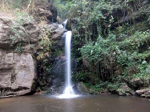
Highlights along the way to Wat Phra That Doi Suthep include the Chiang Mai Zoo at 3.6 km from the old city, Wang Bua Baan viewpoint and falls at 5.5 km, Monthatarn waterfall at 7.0 km, a viewpoint worth a quick stop at 9.8 km, and the wat at 14.4 km.
From the wat, major points include Bhubing Palace at 5.0 km from the wat, the sharp right turn at 5.9 km, a viewpoint on the left with a dirt lot at 7.2 km, the slightly lower summit of Doi Suthep on the left (north) side of the road at 7.9 km, and the parking area at 9.3 km.
Route Description
 The Trailhead
 Sunset on Doi Pui
Trip statistics from Doi Pui Saddle:
1.0 kilometers one-way, 140 meters elevation gain out with none on the return
The easiest route up Doi Pui begins at the northern end of the saddle between Doi Pui and Doi Suthep. There is plenty of room to park, and an abandoned information center at a fork in the road. The left side is gated shut with a sign marking it as a prohibited area (presumably just applying to vehicles, or at least this was the assumption I chose to make). If you really wanted to, a motorbike could be driven around the gate, but the walk is really not that difficult.
From behind the gate walk up a paved road, now no longer in use, through the forest. There are not any views, but the forest itself is really quite scenic. The road makes a couple of switchbacks and after about 10 minutes you come to a fork with a dirt road traversing to the right. Take the right fork, and within a couple of minutes you reach a small clearing with a sign on the far side marking the trail to the summit. Follow the trail another 10 minutes or so to the well marked summit area. The summit marker is inscribed with ยอดดอยปุย (yot doi pui) which translates to Doi Pui summit.
Alternative 1:
Similar to the route above, but you could follow the paved road to its highpoint by taking the left fork. From here you will have to bushwack through the forest to the highpoint of the ridge, and then pick up the trail along the ridge to the summit. The bushwacking isn’t as hard as it looks, but it is really better to take the first suggestion.
Alternative 2:
There is a campground 700 meters further down the summit road from the abandoned building at the saddle. Park at the large parking area near the campground and locate the trailhead (looking up the mountain the trailhead is to the left, where the road forks approaching the campground). From here it is 1.6 km each way to the summit, with about 160 meters elevation gain (I did not know about this option until seeing the top of this trail near the summit area, it is likely a pleasant walk through the forest and I would recommend giving it a try).
There are many hiking trails and dirt roadbeds on Doi Pui, and longer options are available and worth considering. The mountains around Chiang Mai are a great environment to spend some extra time if you have it. SummitPost member Ze has a nice trip report overviewing a longer journey on the moutain.
Flora and Fauna
 Second Tier of Monthatarn Falls
 The forests in Doi Suthep-Pui National Park consist of mixed deciduous forest at the lower elevations and tropical evergreen forest at the higher elevations. The most common species of trees are in the Dipterocarp, Beech, and Magnolia families.
The park is the home to over 300 species of birds and at dawn and dusk visitors may also see bats feeding in the sky. Macaques are common in the forest though there are other species of monkeys, like gibbons, present as well. Other mammals include the barking deer (muntjac) and wild boar. The crocodile salamander is a rare species and Doi Suthep-Pui is one of four locations in Thailand it is known to inhabit.
Red Tape
 Wat Phra That Doi Suthep
No real red tape in terms of access, the summit is located in Doi Suthep-Pui National Park and accessible year round and throughout the day. If visiting any of the other locations you will be limited to opening hours, most notably 7:00 am to 5:00 pm at Wat Phra That Doi Suthep (hours change frequently) and 8:30 am to 4:15 pm at Bhubing Palace.
Fees for non-Thai visitors are ฿30 at the wat and ฿50 at the Palace. Monthatarn Waterfall has a ฿200 fee and the other stops along the way are free.
If visiting the wat, note that modest dress is necessary. Most visitors wear long pants but a few enter in shorts. If wearing shorts, technically they should reach your knees. I recommend wearing long pants to avoid looking so much like the typical ignorant tourist. Short sleeves are ok, but your shoulders should be covered (no tank tops). Shoes must be removed before entering the interior of the wat.
When to Visit
 Interior of Wat Phra That Doi Suthep
There are three seasons in Thailand, and Chiang Mai is best visited during the cool season (though it is more crowded during this time). This season lasts from November through February, with comfortable temperatures during the day and cool temperatures at night.
The hot season lasts from March to May, and not a bad alternative time to visit. This is especially true if you can time your visit to be around April 15 when the entire country celebrates Songkran, the Thai New Year festival. During Songkran the streets are filled water fights and participants rubbing scented chalk on fellow partiers’ faces. I highly recommended the experience.
The rainy season lasts from May until November with high humidity and daily downpours (though they are often brief). If you are planning to do much trekking near Chiang Mai this season is best avoided.
Lodging
 Bhubing Palace
Camping in Doi Suthep-Pui National Park is an option at the campground just 700 meters down the road from the Doi Suthep/Doi Pui saddle parking location. Even so, hotels are generally cheap in Thailand and most visitors will opt for that type of accommodation.
Many westerners stay in the area near the Thapae Gate on the east side of the Old City and along Loi Khor Road between the Old City and the Ping River. This is where most of the nightlife in Chiang Mai is found, but keep in mind it is nothing compared to what is found in Bangkok and Pattaya. Venues are mostly simple outdoor beer bars up and down Loi Khor Road.