Also the Valley of Aosta has its glacial erosion pyramids, among which I want to illustrate those relating to three specific locations:
1) - The erosion pyramids in the valley above the small Town of Saint Pierre;
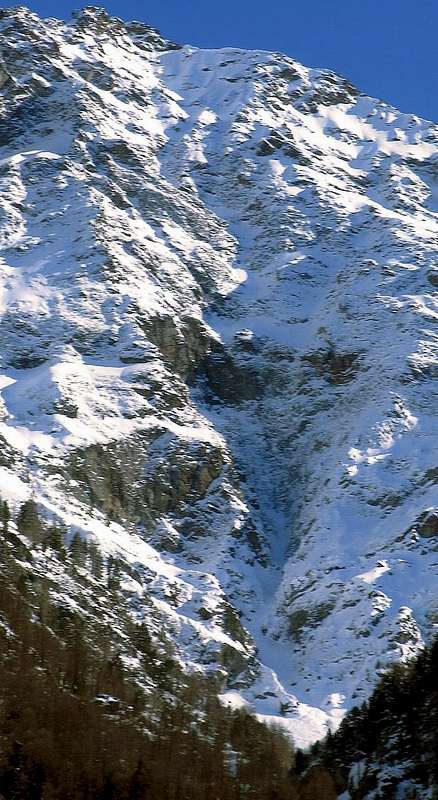
2) - The pyramids in the highest part of the Gorgia del Dard, which Abbot Joseph Maria Henry baptized in 1800 as the "Devil's Wall";
3) - The pyramids or rather the steep wall looming over the Regional Road in the stretch that connects the Municipalities of Nus (ad Nonum Praetoriae) and Quart (ad Quartum Praetoriae), both immediately at the eastern gates of the City of Aosta (the ancient Augusta Praetoria Salassorum of 25 BC), between the two towns of La Planta (or Plantaz) (540 meters) and the small village with Chétoz tower
(621 meters).
In this work we consider
the second of the items listed above, shifting our attention to the
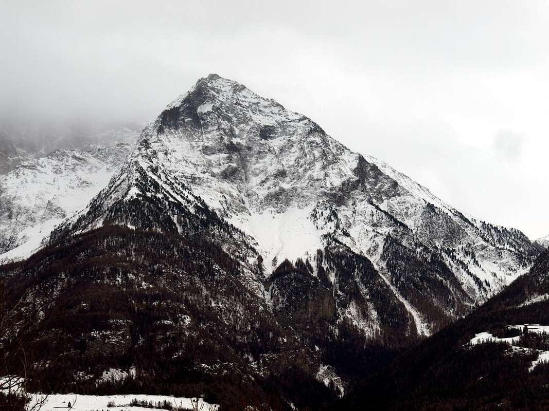
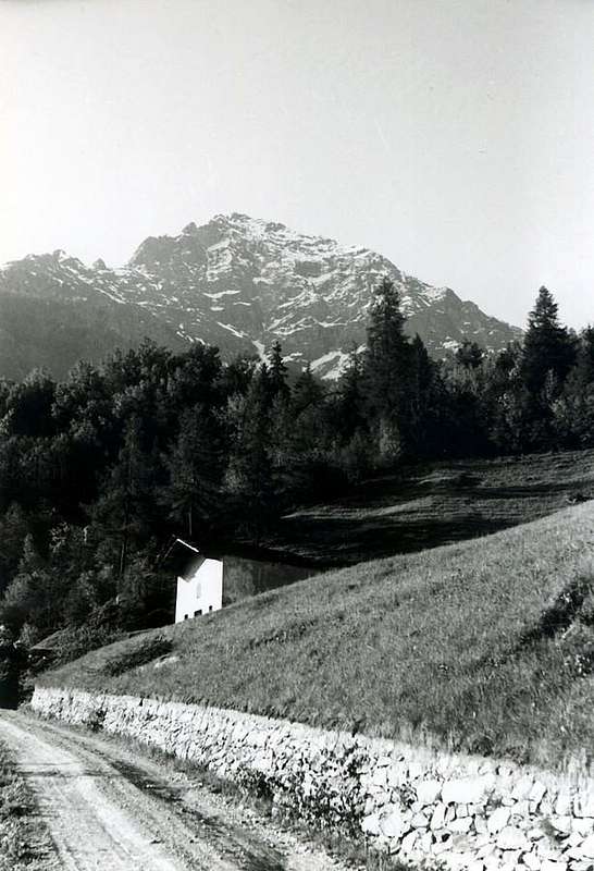
Monte Emilius Group (3559m) immediately above the City of Aosta
(583 meters, Km 125.6 from Turin and Km 100 with the A1 motorway , as well as Km 69 from Ivrea). For greater precision on the Northern slopes of the twin pyramid of Becca di Nona
(3142m), where it dominates the Gorgia del Dard or Dard 's deep and narrow Valley, in turn furrowed by the Torrent de Comboé which is inserted in the Dora Baltea at the border of the Municipalities of Pollein
(575 meters to the East) and the Hamlet of Piano Felina in the Municipality of Charvensod
(559 and 746 meters to the West). These erosion pyramids, located at the north-eastern base of
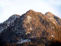
Punta del Dard, called on the map of the paths n ° 4
"Conca di Aosta Pila - Mont Emilius" also as
"Becca de Rien" and on site
"Becca de Ren", that is
"Becca di Nothing ", or rather not considerable top; or and also
"Becca du Rem" (which means
"Becca of Copper" from a nearby ancient mine located on its Western side), they have a wall
about 150 meters long, which also reaches
forty meters in height.
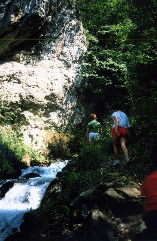
Pano on route towards the Dard 's Gorge above Charvensod by Osw 2015
Anche la Valle d'Aosta possiede le sue piramidi di erosione glaciale, tra le quali voglio illustrarvi quelle concernenti tre specifihe località:
1)- Le piramidi di erosione nel vallone soprastante il Comune di Saint Pierre;
2)- Le piramidi nella parte più elevata della Gorgia del Dard, che l'Abate Joseph Maria Henry battezzò nel 1800 come il "Muro del Diavolo";
3)- Le piramidi o meglio il ripido muraglione incombente sulla Strada Regionale nel tratto che unisce i Comuni di Nus (ad Nonum Praetoriae) e Quart (ad Quartum Praetoriae), entrambi subito alle porte orientali della Città di Aosta (l'antica Augusta Praetoria Salassorum del 25 avanti Cristo), tra le due località di La Planta (o Plantaz)
(540 metri) ed il piccolo Villaggio con torre di Chétoz
(621 metri).
In questo lavoro prendiamo in considerazione la
seconda delle voci sopra elencate, così spostando la nostra attenzione nel
Gruppo del Monte Emilius (3559 m) subito soprastante la Città di Aosta
(583 m, Kilometri 125,6 da Torino e Km 100 con l'autostrada A1, nonché Km 69 circa da Ivrea). Per maggiore precisione alle pendici Settentrionali della sottostante ad Occidente piramide gemella della Becca di Nona
(3142 m), laddove questa sovrasta il Vallone o Gorgia del Dard, scavato e solcato dal ripido Torrent de Comboé, che, a sua volta, si inserisce nel Fiume Dora Baltea al confine dei Comuni di Pollein (575 metri circa, ad Est) e la Frazione di Piano Felina nel Comune di Charvensod (559 e 746 metri, ad Ovest). Questa serie di calanchive piramidi di erosione, situate alla base Nordorientale della roccioso-boschiva
Punta del Dard; inoltre quest'ultima viene chiamata sulla Carta dei sentieri n° 4 "Conca di Aosta Pila - Mont Emilius" anche come
"Becca de Rien" ed in loco
"Becca de Ren" cioé
"Becca di Niente", ovvero sommità non considerevole; oppure ed anche
"Becca du Rem" (che significa
"Becca del Rame" da una vicina antica miniera posizionata sul suo lato Occidentale), presentano una muraglia lunga
circa 150 metri, che raggiunge anche una
quarantina di metri in altezza.
From the floor valley Paths for GETTING THERE
Here are some ways of approaching the place characterized by the erosion pyramids of the so-called "Devil's Wall", as Abbé Joseph Maria Henry, parish priest of Valpelline but native of Courmayeur, baptized it; to this end, these in themselves already constitute splendid walks in a natural area that is still well preserved. Therefore approaches for the starts I mediate tall and forced passage through Pousses Alp, also by Rongachet Bridge (about 1113 meters) and the water intake of La Mare resort (about 1186 meters) or and better the locality called La Mare (ie "The Mother", logically of all waters) for departures middle low, always passing along the Dard Vallon, Alp and Ponteilles Waterfall at the entrance into upper Dard Gorge, near the fork 1975 meters around. There are several possibilities to enter the Vallone-Gorgia del Dard, both starting from the hamlets of the Municipalities of Pollein (about 575 meters and 5 Km from Aosta) and Charvensod (about 746 meters and 5 Km from Aosta) located on the valley floor, or partially using the Regional Road that from Aosta goes back to the Pila District, after having crossed the Bridge of Pont Suaz, preceding the homonym Hamlet (about 564 meters) and over the Dora Baltea River. It depends on what type of excursion you want to do, concerning both the type of landscape and its environment and for the length of the route to be covered. To this end, we give some general indications, it being understood that the choice of route can be varied at will. Without forgetting that, to visit the erosion pyramids, it is also possible to reach them with a downward path; or coming from above as for example from the same Valley of Comboé, passing through the Waterfall and the Ponteilles Mountain Pasture. Or from the Alpine Pasture of Les Pousses, located on the slopes of Punta del Dard (2033m). and also from the nearby Alpine Pastures of Le Vaccoz (1469m), or Les Leyzères (1517m); if not even with a long crossing to the East from the Pila Resort. in any case, always approaches with obligatory passage through Alpe Les Pousses, for medium-high departures, and from Rongachet Bridge or from La Mare water intake, for medium-low ones, and however always passing through the Gorgia del Dard, Alpe and Ponteilles waterfall and entry into the overlying Comboé 's small Valley at the crossroads around 1975 meters.
Lanscape & details on various possibility of routes towards the Dard 's Gorge Area above the underlying Charvensod Municipality, by SalVal 2012
1) Always departures from the sector I mediate tall of the Regional Road for Pila to altitude about 1000 metres: a)-, b)-, c)-, d)-, e)-, f)-, g)- From and towards the small hamlets of:
a)- the Fraction of Saint Saloo also called Salò Village
(1307m) and through concomitant path with the dirt road "poderale" for Les Gorres in the first line and then with autonomous path
n° 14E that, passing to South of the village and again crossed the "poderale" toward East-southeast, it goes to join around himself to altitude of
1480 metres about with the path
n° 14D, coming from few above the Fraction of Château-Charvensod
(823m), passing into Bondine's Village
(1043m);
b)-Les Gorres Village
(1385m), through the preceding route; or from the alternative
1332 metres on the Regional Road of Pila with deviation to the left (descriptive poster and of prohibition of transit with auto) reaching on dirt road "poderale" the village. Same give to continue Southeast with the path
n° 14E and then to reach the alternative
1500 metres around, as soon as before the Alp Les Leyzères
(1517m); from this to rejoin him, through brief slope of connection, to the precedent path
n° 14D and to reach Les Pousses Pasture
(1601m), to the entry of the "Vallone" of the Dard or the Valley of the Waterfall.
c)- with departure from the small Village of Le Champex (
1290m; attainable after two elbow windings road on the road for Pila and with a brief line of dirt road) to go himself with the path
n° 2, coming from Reverier Dessus
(1124m), toward West actually to reach the path
n° 14D as soon as above the same one and with this to continue toward Les Pousses Pasture
(1601m), to the entry of the Valley of the Dard and underlying the homonym point
(2033m).
d)- : Les Pousses attainable also through the dirt road "poderale" that from Les Gorres Village, with very wide turn toward Southwest it touches the Alp of Le Vaccoz
(1469m) for then to reenter toward East-northeast.
* e)- Even from Pila: or with the path
n° 14L that, even beginning from Pila, it passes for the Hermitage of Saint Grat, it goes down to the Combatissière's Pastures (
1750m; splendid "rascards"), Les Usellières
(1566m), Vaccoz and from these passing under and in parallel to the road poderale) through the continuation of the dirt road or with the path
n° 14L, described hardly above, to reach Les Pousses Pasture
(1601m) to the intersection with the path
n° 14D, as soon as over the long stall.
f)- beginning from the Alp Les Leyzères (attainable from the path
n° 14E that salt from the alternative among the two small Villages of Les Carnières
(1180m) and La Pissine Salà
(1307m); or with the long path
n° 14L that, departing from Pila-Hermitage of St. Grat, it entirely crosses the Black Forest of Combattissière), through the continuation of this last toward East or on the impending and parallel dirt road, to reach shortly Les Pousses Alp.
g)- with departure from Les Pousses oppure Pouce
(1601m), at the beginning of Dard's Valley, through the path
n° 14D, along a diagonal to South and near the old brook for irrigation, arriving to Comboé Torrent in altitude 1670m around; and, after forded across on the same and crossed the dirt road, reach the Ponteilles
(1706m) Pastures.
* * h)- Lower Variant: even through the below dirt road, fording twice the Comboé Torrent reach the alpage. From Alp, through a more steep slope side by side in East with the Waterfall of Ponteilles
(1750m around).
2) From the floor valley between the Fractions Pont Suaz, Pian Felina, High Felina, Roula(z) (Charvensod Municipality) and Chenaux, Chenières (Pollein):
![]() Starting La Mare already into Gorge,
by emilius 2006
h)-, i)- from the little Fractions and Villages toward:
h)-
Starting La Mare already into Gorge,
by emilius 2006
h)-, i)- from the little Fractions and Villages toward:
h)- with beginning from the Fraction of the Pont Suaz
(567m), near the homonym bridge on Baltea Dora Stream it to the doors of Aosta, immediately to depart from the alternative behind the little church and to leave the Regional Road for Pila on the right; to take to the left instead that in asphalt and direct toward South. When this, concomitant with the path
n° 14D/intervalleys n° 102 (what it crosses the Groups of the Mount Emilius, Point Tersiva and Mount Glacier reaching the lakes of Champdepraz) develops on the left (East), to abandon it; to continue through the aforesaid path and on the fund of a small "vallone" reaching Charvensod, situated on the hill in south of the Aosta's Town, between the places of Les Condemines and Le Château
(820/3m). From the Chief town, abandoning to the right (South) the aforesaid path that is addressed to Peroulaz Fraction
(1359m), to go up again instead Southeast the impending hill through the path
14L that, through the wood and meadow lines, it reaches first the dirt road and then the inhabited area of Bondine (
1043m; beautiful fountain in stone in the small place of the center village); from this to continue, same direction and same path, reaching the overhanging Village of Les Carnières
(1180m). Left the alternative to South, with path
n° 14E, addressed to La Pessina Sala(à) and Les Gorres
(1307m, 1385m), to continue instead with
14D and, crossed the Regional Road to quota
1260 metres, actually to the alternative
1460 meters, impending this last pasture. From this point to continue with the approaches under described to Les Pousses
(1601m).
i)- from the Village of Pian Felina also called Plan Félinaz
(565/68m), with the path
n° 14 that it passes to the superior Fraction of Felina
(588m) to join himself with that coming from that of Roula(z)
(835m around), with
numeration 14 again, and in quota
835m around for then to reach at first the dirt road "poderale" for the Village of Le Pointier
(976m) and immediately after the same and connecting itself to the Village of Reverier du Tzat passing between woods and meadow expanses.
![]() Starting from Reverier du Tzat to the Dard Gorge,
by Osw 1985
Starting from Reverier du Tzat to the Dard Gorge,
by Osw 1985
Si suggeriscono qui alcune modalità di avvivinamento al luogo caratterizzato dalle piramidi di erosione del cosiddetto
"Muro del Diavolo", come lo ha battezzato a suo tempo (1902) l'Abbé Joseph Maria Henry, Parroco di Valpelline ma nativo di Courmayeur; all'uopo le medesime costituiscono già di per se stesse delle splendide passeggiate in un'area naturale non protetta ma ancora ben conservata. Quindi approcci per le partenze medio tramite il passaggio più in alto ed obbligogatoriamente attraverso l'Alpe di Pousses; inoltre anche dal ponte di Rongachet e dalla sottostante presa d'acqua della località detta La Mare (cioé
"La Madre", logicamente di tutte le acque) per le partenze medio-basse, passando sempre lungo la cascata del Vallone o Gorgia del Dard , dall'Alpe con cascata di Ponteilles all'ingresso della gola del Dard superiore, vicino al bivio
1975 metri circa. Diverse sono le possibilità di inserirsi nel Vallone-Gorgia del Dard, sia partendo dalle frazioni dei Comuni di Pollein e Charvensod site sul fondovalle, sia utilizzando parzialmente la Strada Regionale che da Aosta risale verso il Comprensorio di Pila, dopo aver oltrepassato il Ponte del Pont Suaz sopra la Dora Baltea. Dipende da che tipo di escursione si voglia compiere, concernente sia la tipologia del paesaggio e del relativo ambiente che la lunghezza dell'itinerario da percorrere. All'uopo diamo alcune indicazioni di massima, fermo restando che si possa variare a piacimento la scelta del percorso.Senza dimenticare che, per visitare le piramidi di erosione, é inoltre possibile raggiungere le medesime con un percorso in discesa; ovvero provenendo dall'alto come ad esempio dal Vallone stesso di Comboé, passando per la Cascata e l'Alpeggio di Ponteilles. Oppure dall'Alpeggio di Les Pousses, situato alle pendici della Punta del Dard
(2033 m) ed anche dai viciniori Alpeggi di Le Vaccoz
(1469 m), oppure di Les Leyzères
(1517 m); se non addirittura con lunga traversata ad Oriente dal rinomato Comprensorio di Pila. Sempre avvicinamenti con passaggio obbligato tramite l'Alpe Les Pousses, per le partenze medio-alte, e dal Ponticello di Rongachet oppure dalla presa dell'acqua di La Mare, per quelle medio-basse, e comunque sempre transitando dalla Gorgia del Dard, Alpe e Cascata di Ponteilles ed ingresso nel soprastante Vallone del Comboé al bivio
1975 metri circa.
1) Sempre partenze dal settore medio alto della Strada Regionale per Pila a quota 1000 metri circa: a)-, b)-, c)-, d)-, e)-, f)-, g)- Da e verso i piccoli Villaggi di:
a)- dalla piccola Frazione di Saint Saloo costituente il Villaggetto di Salò
(1307 m) e con sentiero concomitante con la strada poderale per Les Gorres nel primo tratto e poi con sentiero autonomo
n° 14E che, passando a Sud del villaggio ed attraversata nuovamente la poderale verso Est-sudest, va a congiungersi a quota
1500 metri circa con il sentiero
n° 14D, proveniente da poco sopra la Frazione di Château-Charvensod
(823 m), passando dal Villaggetto di Bondine
(1043 m).
b)- dal Villaggetto di Les Gorres
(1385 m) tramite la via precedente; oppure dal bivio
1332 m sulla Strada Regionale per Pila con deviazione a sinistra (cartelli segnaletici e di divieto di transito con auto) raggiungendo su strada poderale il villaggio medesimo. Dallo stesso continuare a Sudest con il sentiero
n° 14E e poi raggiungere il bivio
1500 metri circa, appena prima dell'Alpe Les Leyzères
(1517 m); da questo ricongiungersi, per mezzo di breve salita di collegamento, al precedente sentiero
n° 14D e raggiungere Les Pousses
(1601 m), all'ingresso del Vallone del Dard, ovvero Vallone della Cascata.
c)- con partenza dal Villaggio di Le Champex (
1290 m, soprastante la Gola del Dard nonché raggiungibile dopo due tornanti a gomito sulla strada per Pila e con un breve tratto di poderale) portarsi con il sentiero
n° 2, proveniente da Reverier Dessus
(1124 m), verso Occidente sino a raggiungere il sentiero
n° 14D, appena al disopra della medesima, e con questo proseguire verso Les Pousses
(1601 m), all'ingresso del Vallone del Dard e sottostante l'omonima punta
(2033 m.), tramite la continuazione della strada poderale o con il sentiero
n° 14L, appena descritto sopra, raggiungere l'alpeggio) all'incrocio con il sentiero
n 14D, appena oltre la lunga stalla.
d)- : Les Pousses é raggiungibile anche con poderale che da Les Gorres, con giro molto largo Sudovest, tocca l'Alpe di Le Vaccoz
(1469 m) rientrando subito verso Est-nordest.
* e)- O partendo da Pila: con il sentiero
n° 14L che, addirittura iniziando da Pila, passa per l'Eremo di San Grato, scende alle Alpi di Combatissière (
1750 m; due splendidi
"rascard" od antiche baite in legno-pietra), Alpe Les Usellières
(1566 m), Alpeggio Vaccoz e da questi, passando sotto ed in parallelo alla poderale, raggiungere l'alpeggio.
f)- iniziando dall’Alpe Les Leyzères (raggiungibile dal sentiero
n° 14E che sale dal bivio tra i due piccoli Villaggi di Les Carnières
(1180 m) e La Pissine Salà
(1307 m).
g)- con partenza da Les Pousses o Pouce
(1601 m), all'inizio della Vallone del Dard, tramite il sentiero
n° 14D, e con un lungo diagonale a Sud viciniore al vecchio ruscello di irrigazione ed al di sotto della cresta divisoria della Punta del Dard
(2033 m), arrivando al Torrente di Comboé in quota
1670 metri circa; quindi guadare sullo stesso ed attraversare la strada sterrata poderale, pervenendo all'Alpeggio di Ponteilles
(1706 m).
* * h)- Variante Bassa: raggiungere l'alpe attraverso la sottostante e parallela poderale, guadando su di un ponticello il Torrente di Comboé e poi affiancandolo. Dall'Alpe, lungo un pendio più ripido ed erto sul lato Orientale della Cascata
(1750 metri circa).
2) Partenze dal fondovalle tra le Frazioni del Pont Suaz, Pian Felina, Felina Alta e Roula(z)(Comune di Charvensod) e Chenaux, Chenières (Comune di Pollein):
![]() Starting by Chenaux to the Gorge,
by Osw 1985
h)-, i)-
Starting by Chenaux to the Gorge,
by Osw 1985
h)-, i)- da e verso le Frazioni ed i piccoli Villaggi di:
h)- con inizio dalla Frazione del Pont Suaz
(567 m), presso l'omonimo ponte sulla Dora Baltea alle porte di Aosta, partire dal bivio subito dietro la chiesetta e lasciare la Strada Regionale per Pila sulla destra; prendere invece quella in asfalto a sinistra e diretta verso S. Quando questa, concomitante con il sentiero
n° 14D/intervallivo n° 102 (che attraversa i Gruppi dell'Emilius, Tersiva e Mont Glacier arrivando fino ai laghi di Champdepraz) svolta sulla sinistra (Est), abbandonarla; continuare per mezzo del suddetto sentiero e sul fondo di un valloncello raggiungendo Charvensod, situato sulla collina a Meridione della Città di Aosta, tra le località di Les Condemines e Le Château
(820/3 m). Dal Capoluogo, abbandonando a destra (Sud) il sentiero predetto che si indirizza alla Frazione di Peroulaz
(1359 m), risalire invece a Sudest la soprastante collina tramite il sentiero
14L che, attraverso il bosco e tratti prativi, raggiunge prima la strada poderale e poi l'abitato ristrutturato di Bondine (
1043 m; bella fontana in pietra nella piazzetta del centro villaggio). Da questi continuare, stessa direzione e medesimo sentiero, raggiungendo il soprastante Villaggio di Les Carnières
(1180 m). Lasciato a Sud il bivio, con sentiero
n° 14E, indirizzato a La Pessina Sala(à) e Les Gorres
(1307 m, 1385 m), proseguire invece con
14D ed, attraversata la Strada Regionale a quota
1260 m, sino al bivio
1460 m, soprastante quest'ultimo alpeggio Da questo punto salire con gli avvicinamento sotto descritto per Les Pousses
(1601 m).
i)- dalla Frazione di Pian Felina o Plan Félinaz
(565/68 m) con il sentiero
n° 14, che passa alla Frazione superiore di Felina "Alta"
(588 m) per congiungersi con quello proveniente da quella di Roulaz
(632 m), con
numerazione 14 ancora ed a quota
835 metri circa, per poi raggiungere dapprima la strada poderale per il piccolo Villaggio di Le Pointier
(976 m) e subito dopo lo stesso collegarsi all'appena soprastante Villaggio di Reverier du Tzat o Reverier del Gatto
(1019 m), passando tra idilliaci boschi e vaste distese prative.
![]() Low Reverier going at Dard Gorge,
by Osw 1985
Low Reverier going at Dard Gorge,
by Osw 1985 So this phenomenon was made public in the R.M. o Monthly Magazine of the C.A.I. 1903 between pages 73 - 78 on "TWO NEW WAYS TO MOUNT EMILIUS (m. 3559)" THE EASTERN AND WESTERN CRESTS. In the story of a competition organized by the T.C.I. (Italian Touring Club) in the previous year 1902 concerning twelve monographs of Italian mountains. Thinking of making the
. Leaving the botanical part to Prof. Lino Vaccari and to Reverends Thomasset and Bionaz for deal with the photographic part, our Abbot, hired the best local guide or Gregorio Comé, decided to
So, after having .
. Reverend Bionaz on the back of a mule to Comboé in the hospitable house built by Reverend Canon Carrel, thanks to the key kindly granted by Reverend Canon Bozon:.
offers you this splendid itinerary, even if it is possible to go up by car from Aosta, passing the Pont Suaz over the Dora Baltea, and, after passing the Municipality of Charvensod, reach the crossroads between the three villages of Reverier Dessous , Reverier du Chat or Tzat and Reverier Dessus
with its splendid waterfall. Ah, remember you though that the mule no longer exists ...
2)- Le piramidi nella parte più elevata della Gorgia del Dard, che l'Abate Joseph Maria Henry battezzò nel 1800 come il "Muro del Diavolo". Così questo fenomeno veniva reso pubblico nella R.M. o Rivista Mensile del C.A.I. 1903 tra le pagine 73 - 78 a proposito di "DUE NUOVE VIE AL MONTE EMILIUS (m. 3559) "LA CRESTA EST E LA CRESTRA OVEST, Nel racconto di un concorso indetto dal T.C.I. (Touring Club Italiano) nel precedente anno 1902 concernente dodici monografie di montagne italiane. Pensando di fare concorrere nel medesimo anche la
. Lasciando la trattazione della parte botanica al Prof. Lino Vaccari ed ai Reverendi Thomasset e Bionaz la parte fotografica, il nostro Abate, ingaggiata la miglior guida locale ovvero il Gregorio Comé, decideva di
. Così, dopo aver
il Reverendo Bionaz a dorso di mulo a Comboé nella casa ospitale fatta erigere dal Reverendo Canonico Carrel, grazie alla chiave cortesemente concessa dal Reverendo Canonico Bozon:
. Quindi il nostro
vi ripropone questo splendido itinerario, anche se é possibile salire in auto da Aosta, passando il Pont Suaz sopra la Dora Baltea, e, superato il Comune di Charvensod, raggiungere il bivio tra i tre villaggetti di Reverier Dessous, Reverier du Chat or Tzat e Reverier Dessus
con la sua splendida cascata. Ah, ricordatevi però che non esiste più il mulo ...

 1087 Hits
 79.04% Score
 10 Votes