FRIDAY (continuation from El Yunque report)
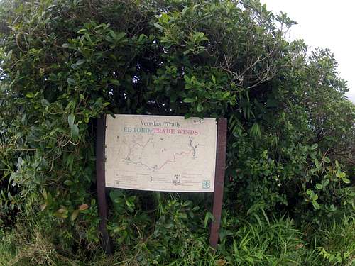
The park opens at 7:30, so I got out of my bag at 7AM and hung my stuff out to dry below and on top. (If the rangers came, I would have told them I got stuck on the mountain last night, but they did not). I stayed until 10:30 when the first tourists came up. I packed up my stuff and started down Road 10. I walked this all the way down to Route 191 and took a right. There will be a sign stating the road is closed to vehicles. I walked down the road for about 15 minutes before I came to the trailhead sign on the right, “El Toro Trail.” It says the trail is closed and has been for some time. I rested a bit and reorganized my bag. I drank most of my water because I read an old hiking report stating there was water on the first part of the trail going up. After a rest, I started hiking at 12:30.
NOTE: This is really the “Tradewinds Trail” head. The Tradewinds Trail goes for 4 miles to El Toro peak, and then descends to the other side for 2 ½ miles as “El Toro Trail to Route 186. This trail is and has been officially closed for some time now due to wash outs and reconstruction, but it’s do-able if you have a need for a tough hike.
TRADEWINDS TRAIL
0-.5 mile: This first quarter mile is easy to walk, but tricky to navigate. There is a section that is washed out, so you have to climb down and up a detour and get back on the main trail. There is orange and yellow marking tape designating the mail route and the detour route, so you can get confused here. I would suggest getting a third mark and place it on the same tape you use, leaving the other color by itself. Once on the main trail, the walking is fairly easy—just wet and slippery.
.5--1.0 mile: At .6, there is a rock overhang in case it’s raining. There are 3 leaky rain shelters after this until 1.0 mile. Easy to hike, but slippery.
1.0—2.0 mile: The path shrinks to an overgrown footpath—some places you can’t notice the path you’re walking on. The razor grass comes up on both sides to your waist or chest. Be careful with your eyes when you bend down to avoid the tree branches and vines. Good views of the shaded forest surround you. A few streams to cross—knee deep when running full. You will cross 2 small wooden foot bridges—but be careful—very slippery.
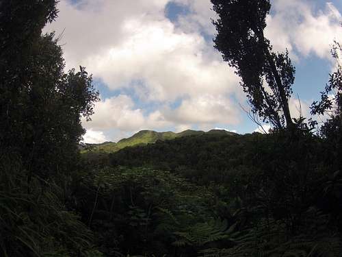
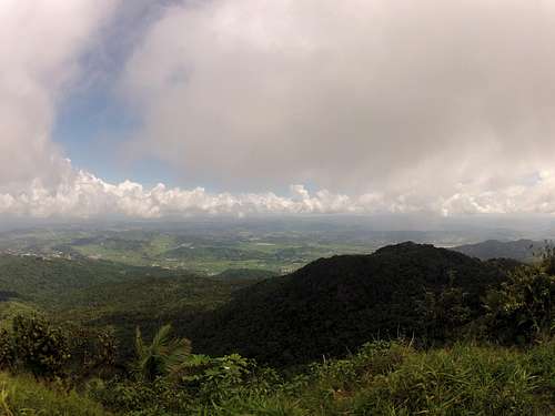
![Trail 1]() View of El Toro Peak
View of El Toro Peak
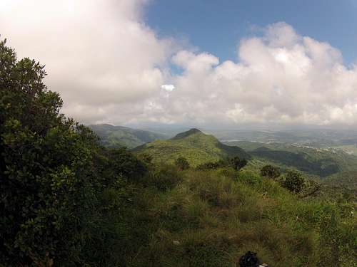
2.0—3.0 mile: From 2.0 to 2.4, you will come across your last water sources—small water steams falling over rocks. Load up your belly and your camelback here to give you enough to get back down. You will be traversing the mountain, a little elevation here. Some parts of trail overgrown and water-logged.
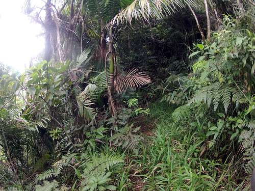
![Trail 2]() Nice part
Nice part
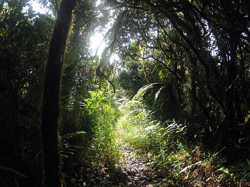
![Trail 3]() Nice part
Nice part
3.0—3.5 mile: Continue traversing mountain, but you will feel the incline in elevation. Some views of park here. Fallen trees across the path become a pain in the ass. With a backpack, you either have to crawl underneath some or climb over them. You’ll learn to hate these. At about 3.5, there is a sharp turn to the left, but you won’t see it because of the overgrowth and fallen tree. There is an old overgrown trail that goes to the right. Don’t take it. Look to the left and you should see some marking tape about 15 yards down—follow this. Before you move on, mark this turn so you will see it on your return. Your gloves will come in handy on this part as you will need to grab a hold of branches and grass for balance.
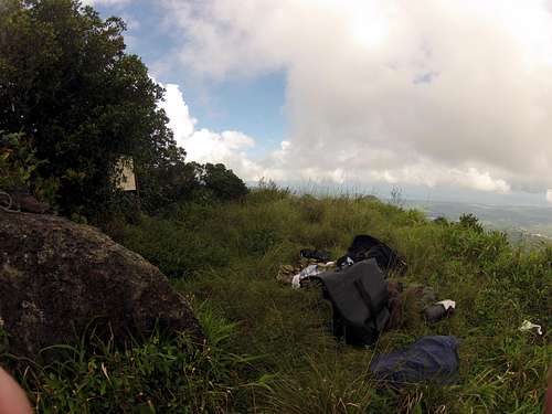
3.5—4.0 mile: Trail elevates dramatically, canopy drops off, more sunlight. Lot of razor grass but less wet. You’ll notice the small switch backs as you near the peak, but you won’t see the peak until the end of this trail, as it pops out from behind some bushes. The wind comes up and sweeps across the top from the north, so I cut the vegetation away from the 2 big boulders and laid my bivy bag down on the left of them. It was good wind protection as I hardly felt it.
![Boulders-1]() Sleep on the left side
Sleep on the left side![Camp Site]() Camp site for 2 nights
Camp site for 2 nights
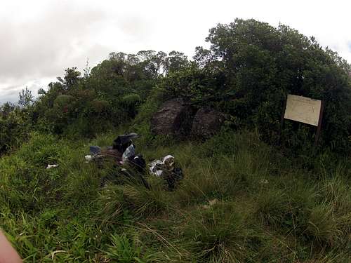
I reached the peak at about 4:30PM, so it took me at least 4 hours. Depending on weather, trail conditions, and what you’re carrying, it may be more or less. The area on the peak is small but accommodating. Some rocks to sit on and dry out clothes. Great views when the clouds break, especially in the evening. Just a small place to pitch your tent though if you have one, not a lot of flat area. There is a trail sign that shows you where you’re at. Behind it, the trail picks up again as the “El Toro Trail”—this will take you down the other side of the mountain to Route 186.
![Sign at Peak]() Trail sign at Peak
Trail sign at Peak
Started to rain, so I climbed into my bag and tarp. Trapped some water from my tarp. Took a nap. Rain broke at 7:30. Removed vegetation around boulder to lay to the right of it. Wind comes up strong from the left side. Air dried some clothes. Drizzled on and off as clouds passed through. From 9:00 to about 11:00, good views of the coastal towns and lights in the evening.
SATURDAY
At 7:30AM rain breaks. Dried out soaked bivy bag and clothes. Not a lot of drying up here—air is damp. Drizzled on-off until 10:30. At 11:00, set off down the El Toro Trail to explore. Left bag behind bushes on right side, took jacket and fanny pack (See Fanny pack web site). Crept down trail that was just as difficult coming up on the Tradwwinds Trail. Very slippery foot trail, more so due to rain. Moved down trail for about an hour and stopped. I hadn’t made it that far and I didn’t want to waste more energy, so I slowly crept up the trail to the peak again.
NOTE: From an older report, some hikers walked up this part from Route 186. It is only 2.2 miles—shorter than the Tradewinds Trail. Their report said the first mile up was easy and only got difficult the last .5 mile—this all before it had been closed.
Once back up on the peak, dried out clothes and sat around. Sun appeared with clouds from 9-10 to around 3:00PM. Lazed around all afternoon and relaxed. Clouds, mist, and drizzle started up at around 7:00PM. Trapped water from tarp. Sat and laid around until evening.
![Trail-5]() El Toro Peak-1
El Toro Peak-1![Trail-6]() El Toro Peak-2
El Toro Peak-2SUNDAY
6:00AM: Ate-drank. 8:00 AM dried out bag and clothes. Reorganized backpack and set off down Tradewinds Trail at about 9:30AM. At 3.5 mile, drank rest of water. 11:00 made it to 2.4 water stream. Filled up belly and Camelbak. Made it to .5 marker and confused with main trail and detour. Couldn’t find detour and had to backtrack to first rain shelter 3 times before finding the detour route. Made it to trail-head 1:30.
NOTE: I did not know this going up, but I placed it in my notes at the beginning for you to avoid what happened to me on the way down.
Hiked up and down to the Palo Corolado Visitor Center and found a tour guide to lend me her cell phone. Remember: There are no taxi’s here—Not permitted. Called Eric to pick me up. Hiked 40 minutes down to the Yocahu Tower and waited for him. There are benches, bathrooms, and a parking lot here. Cleaned and changed. Eric picked me up 3 hours later and took me to Old San Juan. Checked in to Fortuleza Guest House (hostel). Showered and washed clothes. There’s a mini-mart 2 blocks away—bought groceries for room.
MONDAY--WEDNESDAY
Old San Juan: Neat place to kill a few days. Only 2 hostels that I know of here. The Posada San Fransisco and The Fortuleza Guesthouse. There is another Hostel Guesthouse right around the corner from the Fortuleza, but nobody answered the bell after three different attempts. The Posada San Francisco is not a good choice. It is located in a 6-floor building, but the first 3 floors are private businesses and offices. The reception desk for the hostel is located on the 6th floor, and you have to either hike up 6 floors to get there, or wait for the one small elevator that the entire building uses. I went up to check it out on Monday, and the reception girl was quite a snobby rag. Didn’t offer to show me a room, told me a single price depends on the season—low price is $50/dorm $40. I got the feeling that they wanted to impress people as if they were a classy-hotel. There was also a mom there enquiring about their security for her daughter. . . .
The Fortuleza Guesthouse (located on 303 Fortuleza Steet), to my luck, was quite the opposite. The old guy in charge, Ramades, was very kick-back. I rented a single for $30 (Dorms are $22). It’s street-level entrance, and you get a street-level key to enter (They even place a bottle-opener on your key chain). You can come and go as you like, as late as you like to without anyone checking you out. The place is somewhat a dump, but it’s fine, got laundry and a few kitchens, few balconies. Great location, 2 blocks from the piers (Went to the Bacardi Rum Factory). This part of town has a lot of nightlife on the weekends, plenty of bars, parks, and tourist stores. It’s a great mix of old Puerto Rican architecture and ambiance with modern tourism. I walked the entire Old Town maybe 4 times over the next few days—people very friendly and accommodating. If I return to San Juan, I’ll stay here.
WEDNESDAY: It was cheaper to have a taxi take me to the airport than for Eric to come all the way out, so Ramades got me one for $22. Left SJU in the AM.
Puerto Rico is a great place to visit. Lot so things to do, and the people are wonderful. You can get by with just English, but it would be difficult at times. The downside of hiking here is transportation. I didn't want to rent a car and leave it parked overnight--actually, you can't in El Yunque park. Getting around is expensive, but having a guide with car was better than a rental. I hope to return some day. If you have any questions, e-mail me.
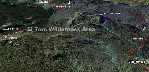
AERIAL MAP OF PEAKS
El Yunque Peak and La Roca are on the left; El Toro Peak is on the right.
Comments
No comments posted yet.