
Comments
No comments posted yet.
|
|
Trip Report |
|---|---|
|
|
34.98465°N / 115.51675°W |
|
|
Dec 30, 2014 |
|
|
Mountaineering |
|
|
Winter |
On Dec 30th 2014 I tried to repeat Bob Burd's and Michel
Holliman's traverse from Fountain to Mitchell.
Having done the Tuolumne triple crown (Tenaya -> Matthes ->
Cathedral) I thought I was up for the Providence Mountains triple crown. I was
wrong. This is a proud day of work, and a proud day that has not yet come for
me. If you want to climb this route, you should first look at Bob's very
helpful account and then read on.
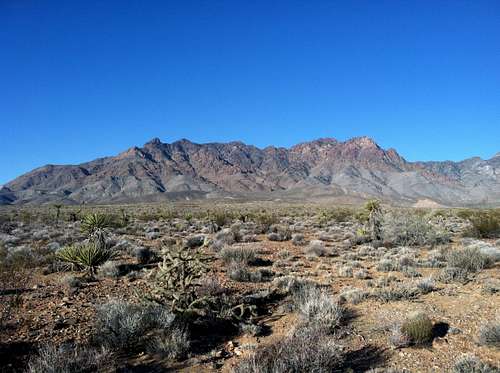
I've been eyeing this mountain range for several years on
the I-40 drive from Flagstaff to CA. The mountains are very remote but
dramatic. Bob's trip report was the only beta I could find about this route,
which I actually tried to do from Foshay Pass 3 years ago, only to be turned
around by some stout 5th class (note, I had not read Bob's report and choose
the wrong start).
As bob notes, the ridge just north of Crystal Springs is
excellent. You have to negotiate a series of outcrops, but the rock quality is
good and none of the climbing is too hard. I was mistaken in thinking that the
crux would be the dihedral/chimneys I could see from my campsite just outside
of the locked gate (yes, the state park is still closed and may be forever it
seems). I was wrong, once you reach the first minor summit then the real work
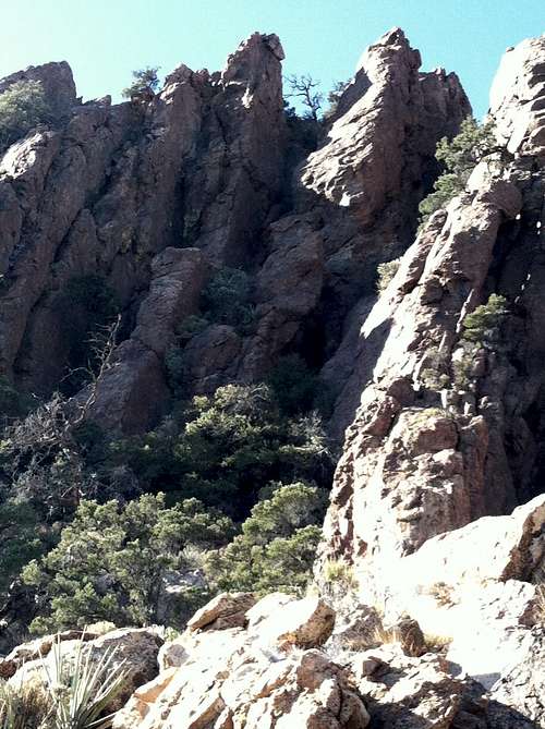
begins. What followed is a very difficult 1.25 miles of complex ridge climbing with challenging route finding. Although the Evolution traverse is on my list (e.g. I have not done it), I expect this is a good training climb if you are thinking about tackling that noble undertaking.
From the first minor summit to Fountain the ridge gradually narrows
to knife edge of Rhyolite. This makes you feel like a hero until you reach the
first key-whole notch with 30-40 foot sheer sides. I made the mistake of
downclimbing too far and then got stuck below Fountain Peak proper.
Given that I was solo-soloing this route I played things
very conservatively and did not summit Fountain. The best way to reach to top
is almost certainly to follow Bob's route along the ridge proper. If you get
too far below your accent options are poor. I was also expecting snow in the
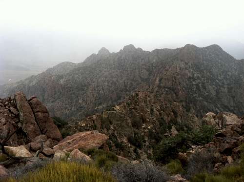
afternoon of the 30th and by noon I could see that summits to the west were
already gathering clouds.
Although my pride hurt quite a bit by missing the Fountain
summit, it was quickly replaced by the pain of a sustained ~200 foot downclimb
on 4th and 5th class moves. This got me to the lowest saddle with snow
beginning to fall. I decided to take a
lower route (the west face below the ridge) the rest of the way to Edgar. While
this was fairly fast I now think I missed more interesting climbing on the
ridge proper and I still had to deal with nasty loose 3-400 pound chunks of
rock trying to kill me, brutal bushwhacking, and serious exposure.
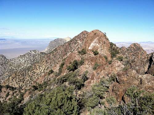
In retrospect I would pass the first outcrop (after the
lowest saddle between Fountain and Edgar) on the west side, but then switch
back to the east face and the ridge proper after the first outcrop and remain
on the ridge the rest of the way to Edgar. From the Edgar summit, this seemed
like the best way to go. But you should note, if you try to repeat this route,
that the landscape is very deceiving. Unlike Tuolumne (or the rest of the Sierra), the most serious hazards
are hidden by vegetation and the fact that the exposure is less dramatic. What
looks like a straightforward ridge hike is really a maze of short sections of 10-80 foot 3rd,
4th, and 5th class with all kinds of questionable rock you want to avoid (balanced
rocks ready to trundle at the top of gullies you want to move through, loose chock-stones in chimneys you *have* to down climb through, and big flakes lurking under a veneer of dirt). The rock quality on the route overall ranges from iron to detached chunks of 10-400 lb pieces of iron. Beware, and move cautiously.
Don't underestimate this route. For me it was, and remains,
a serious testpiece. It also remains as unfinished business. But I would also
say this, if you are a serious alpinist, this route is worth your time. It was
a definet highlight of 2014 for me and a route that I will attack again, but
this time with a partner who is up for 1) obscure climbing, 2) a brutal
traverse, and 3) hanging out in an other-worldly environment unique to tall
desert peaks. While I've written about the difficulties of this route, it is
also transformative, both because of the difficulty and also because of the beauty.
Other beta to consider: Although it will make Bob cringe, I would also considering raping (7-10
m rappels) in at least two places as this would greatly increase speed by
avoiding a lot of downclimbing. Also, as it was sustained snow by the time I
gained the summit of Edgar, I skipped Mitchell and went straight down the North-west
branch of Gilroy Canyon; this is a very good decent option. The Edgar summit
log suggested some of the other ~3-5 parties that climbed Edgar in 2014 also
attempted to reach Fountain. I'm curious
how the reverse route (Edgar to Fountain) is in comparison. Although, for me, it's the
'desert triple crown' that I'll be going after next time...