
|
|
Mountain/Rock |
|---|---|
|
|
34.58953°N / 112.38167°W |
|
|
Yavapai |
|
|
Spring, Fall |
|
|
6178 ft / 1883 m |
|
|
Overview
Glassford Hill is located above the growing neighborhoods in Prescott Valley, 80 miles north of downtown Phoenix, AZ and 6 miles east of downtown Prescott, AZ.
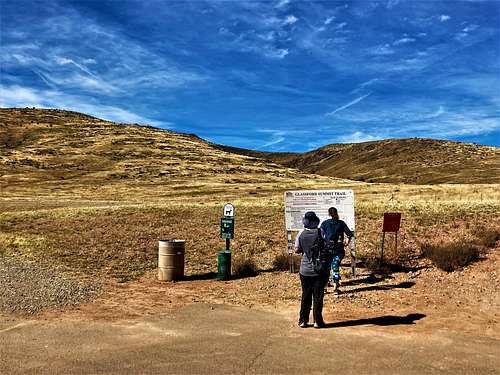
A new trailhead and trail route was opened in 2016 offering easy access to the mountain for an easy out and back hike.
There are two summits, on the mountain. The trail leads to the lower summit at 6,125’. To reach the true summit at 6,178’, one must walk through the open slope towards the towers for about a quarter of a mile off the trail to the USGS marker.
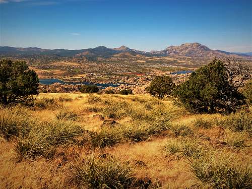
While Glassford Hill is pretty much treeless, it offers excellent views in all directions. It has a prominence of over 620’. One can see the Bradshaw Range to the south and Humphreys Peak to the north. If you walk off from the summit a little bit, there's a pretty view down to Watson Lake.
Glassford Hill has become popular to locals due to its accessibility. It makes for a simple workout hike. Most people don’t care about reaching the true summit and just take the trail to the lower summit.
Glassford Hill is best hiked in spring or fall. However, it is also ideal to hike on a summer morning – at least to the lower summit. Winters can be okay too. Snow may be present December-February, but not always. Glassford Hill can also be windy, so check weather reports before visiting during winter months.
Getting There
The address of the Glassford Hill starting point is 6000 E Antelope Ln, Prescott Valley, AZ 86314.
From the Phoenix Metro area, take I-17 to AZ-69 towards Prescott. Continue west for 26 miles and turn right on Prescott East Highway. Go north for a little over a mile and then take a left on Antelope Lane which leads right to the starting point. Cars are asked to park to the left at the official trailhead just down the road on N. Castle Drive.
There is a road to the actual summit reached from the neighborhoods below. Getting to that road is a bit convoluted. So, if you don't know the area that well, it's best just to use the designated trail.
Route
Once at the parking area follow the trail north parallel to the road and then turn west towards the mountain. The trail is pretty wide and is almost wide enough to be a road, but no vehicles appear to be allowed. The trailhead sign says it is 2.1 miles to the lower summit. However, we had about 2.3 miles – similar to All Trails (see link below). If visiting both summits, it is a little over 5 miles total. The lower summit is less than 100’ above the saddle between it and the true summit.
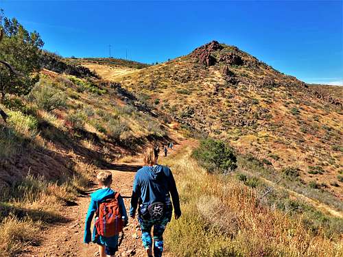
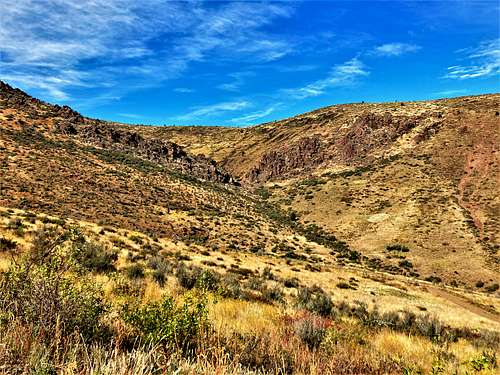
The trail heads towards a water tank and cuts off to the right. Then there are a few switchbacks. After a little over 2 miles, the saddle is reached between the lower summit and the true summit. Look for an open spot in the fence line. Cross over here and walk off-trail towards the towers. It is pretty much an open slope. The ground is rocky, but overall, it is pretty easy to walk through while avoiding brush.
Once near the towers, walk around the fence line and look for the summit rocks. One of them has the USGS marker on it. It is right across from a pile of rocks behind the fence line.
To get a view of Watson Lake, continue walking around the fence line to the west side of the summit area, and walk down just a little bit to take in the view.
The elevation gain to the summit is a little over 1,000’ and the hiking distance is 2 1/3rd miles.
Red Tape
There is no red tape of note. Just do not park at the start of the trail. Park instead at the designated trailhead.
External Links
All Trails: https://www.alltrails.com/trail/us/arizona/glassford-summit-trail
Scott Surgent Trip Report: http://surgent.net/highpoints/az/mobile/glassford_m.html