Google.com has just come out with another wonder called Google Earth. As I understand it, this free download software uses actual satellite photographs taken within the last few years and overlays them onto basic topographic information. The result is a three dimensional representation of the
entire planet! Knowing this made me wonder, "How would a simulated landscape compare to the real world?"
![]()
Mount Shuksan Actual Photograph
|

 | Mount Shuksan Simulated View
© 2006 Google Earth |
|
The technology that makes this program possible was first released under the name of Keyhole. After Google.com purchased the rights, they proceeded to make many improvements. What does this have to do with Summit Post, you ask? I titled this article “A New Tool for Mountaineering” because future versions of Google Earth technology have great potential for the trip planning stages of expeditions. The way it is now, before mountaineers go into a remote area that is unknown, they spend time reviewing topographic maps to get a better understanding about the lay of the land. Google Earth can provide a better idea of what the terrain looks like in 3 dimensions. It would not be surprising to see Google Earth links or the equivalent appear underneath the Topozone Map links currently included on Summit Post mountain pages.
![]()
Three Fingers Actual Photograph
|

| Three Fingers Simulated View
© 2006 Google Earth |
|
One of the best features of Google Earth is the degree to which it is interactive, although some of the controls are still a little difficult to use. A user has the ability to zoom in and out (even to outer space), pan here and there, and click and drag. With a good internet connection, the program will download increasingly detailed photographs the closer you zoom. There is also a feature that allows you to type in the place name or address for automatic viewing. Another feature enables the use of lat/lon coordinates to find your area of interest automatically. This is especially handy for mountaineering interests considering that the names of wilderness areas and mountain ranges are not included in the database. My personal favorite in terms of capabilities is the placemark option. If you want to save a specific location, like Mount Kilimanjaro (see image below), so that you can find it quickly from 50 miles up in space, using one of the drop-down menus, it is easy to do.

| Mount Kilimanjaro Simulated with Placemark
© 2006 Google Earth |
|
You may notice places of high interest including large cities have much greater detail than mountainous or forested areas. A lot could be said about viewing populated areas but I will not cover that here. The lack of finite detail makes Google Earth worthless for inspecting technical rock or ice routes, except the approach. Sorry climbers. Another thing you will notice is that the majority of the topographic structure is extremely simplified and under-exaggerated. To see an example of this, take a look at the small hill that is the Eiffel Tower in Paris. As Scott Patterson has pointed out, there are also some areas left, like the North side of Easter Island, which contain almost no detail whatsoever. Both photo-definition and topographic detail should continue to increase in the future. Google Earth is a work in progress and just a prototype of technology to come. There are two upgraded versions available for a price, one of which incorporates the use of GPS, the other intended for commercial use.
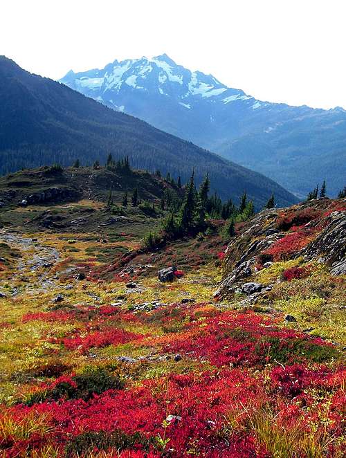
![]()
Eldorado Peak Actual Photograph
|

| Eldorado Peak Simulated View
© 2006 Google Earth |
|
To gain basic foresight into an unknown landscape is invaluable information. This principle has made topographic maps an essential. When considering Google Earth, it will be up to the individual to determine it’s potential value in mountaineering. You can download it
here. Explore, have fun and be sure to let me know what you think of it.
Last of all, I must voice a concern about posting this article. It would be a shame if SP became flooded with Google Earth images. I think most users will agree, there is absolutely no substitute for pictures of the real thing. Please respect Summit Post by not filling image galleries with computer-generated pictures. I will lead the example by not submitting all these Google Earth screen snapshots as individual images to Summit Post.


Comments
Post a Comment