|
|
Mountain/Rock |
|---|---|
|
|
76.92602°N / 16.04839°E |
|
|
Mountaineering, Ice Climbing, Mixed, Skiing |
|
|
4701 ft / 1433 m |
|
|
Overview
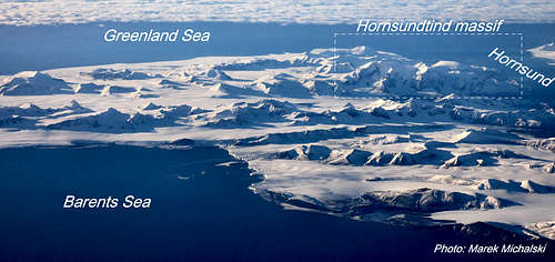
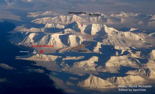
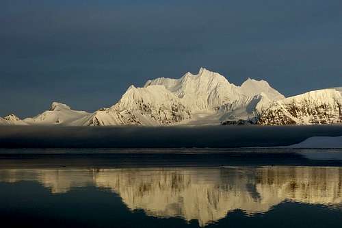
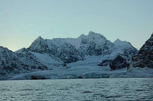
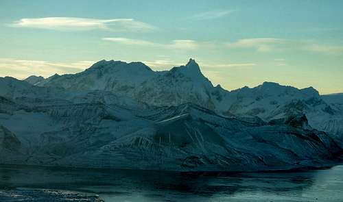
Hornsundtind is the highest massif of the land of the southern cape (Sørkapp) and all of western Spitsbergen south of the Isfjord. It is considered the most beautiful mountain in all of Svalbard. Its characteristic profile is visible from a distance of over 100 km. The Hornsundtind massif stretches latitudinally along the southern shore of Hornsund Bay, from which he sowed name. It is made of dark dolomites.
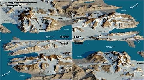
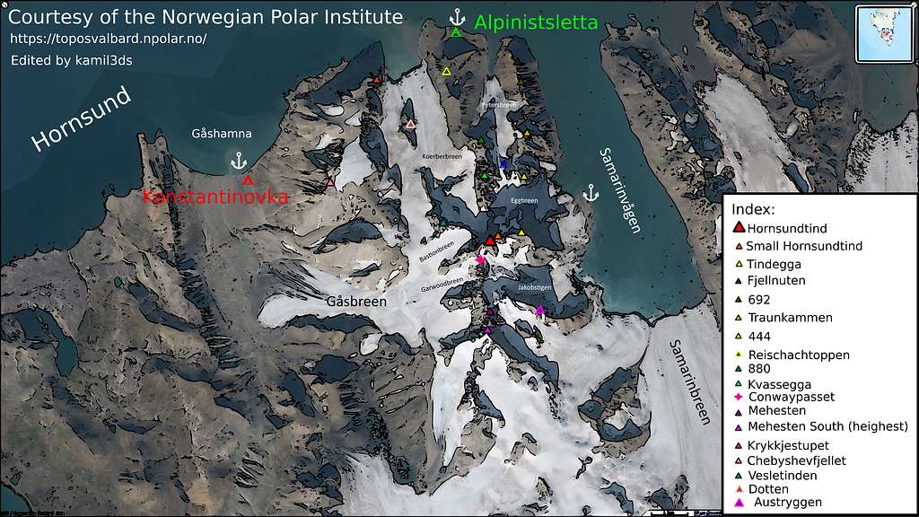
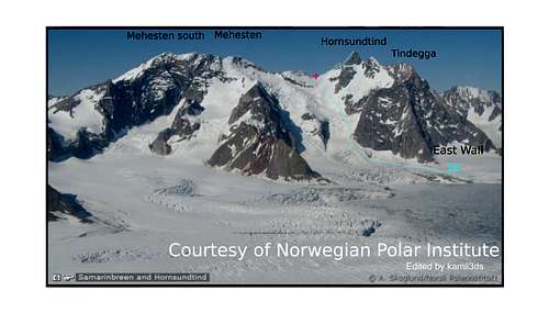
Peak has 5 ridges. Northeast, East, South, West and Northwest.
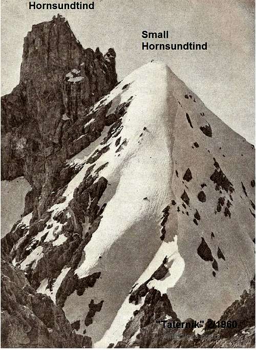
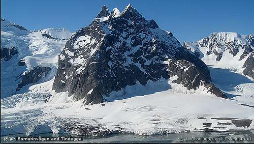
Eastern ridge connects main summit with minor peak called Little Hornsundtind (2nd summit) (1349) and then it turns into the Tindeggi ridge (1270), ending with an East Wall of Tindegga - est. 900m height (mix of ice and rock).
The northeast ridge divide the Petersbreen and Eggbreen glaciers with the minor peaks - Fjellnuten and Traunkammen. To the north falls from the top an almost vertical (average slope of 70 degrees), partially overhung, Northern flank (North Wall), which is about 700 m height. Wall rises at the upper part of the Korberbreen cirque. The wall is bounded by the northern (northeast) ridge, which extends towards the Kvassegga (1003) and further towards to the bay ( Alpinistsletta).
The northwest ridge, with the Vesletinden (928) peak. Unnamed pass, covered by thick glacier connects to The Chebyshev Massif (929), which obscures the view of the summit from the Polish Polar Station , located on the other side of the Hornsund fjord. The Gåsbreen glacier flows westwards, along with the Bastionbreen and Garwoodbreen glaciers, which are separated by the western Bastionen buttress.
To the south there is a long ridge with the Mehesten massif (1378) separated from Hornsundtind by the Convaypasset. A 200-meter rock wall descends to the southeast, with a 50-degree slope, turning into a strongly fractured Jakobstigen glacier which ends with an ice cliff. From the east, the massif is limited by the Samarinvågen Bay.
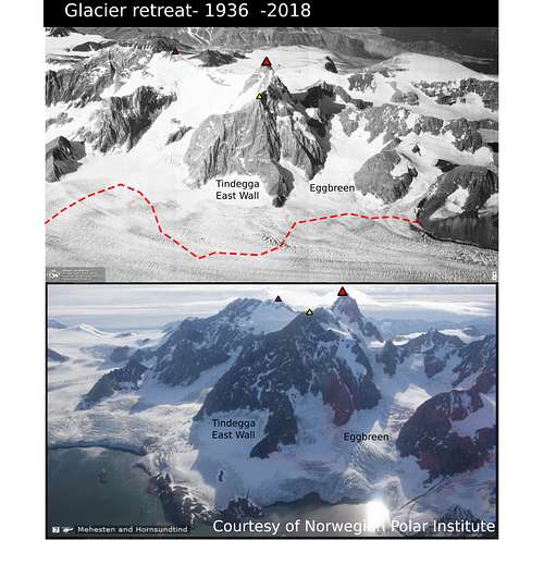
Glacier retreat
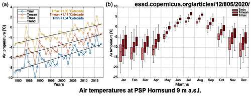
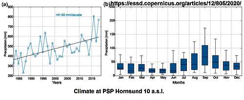
Over the past 30 years, the Spitsbergen glaciers had experienced a major regression.Icefront of the glaciers which flowed into the sea receded several kilometers into the fjords. Their surfaces became heavily crevassed . Warm summers result in rock erosion and stone avalanches. In result, Some paths used by first conquerors became inaccessible or too dangerous.
Getting There
The mountain range Hornsundtind is located in the southern part of the island of Spitsbergen, which is a part of the Svalbard archipelago. The only available airport is in the Longyearbyen city.
| Location | Hotellneset, Longyearbyen, Svalbard, Norway |
|---|---|
| Elevation AMSL | 28 m / 94 ft |
| Coordinates | 78°14′46″N 015°27′56″E |

Flight connections are operated by SAS Airlines. Flight schedule has seasonality. Summer season offers departure on Monday, Wednesday, Friday.
Departure city are Oslo (Capital of Norway) and Tromso. The flight takes about 4.5 hours.
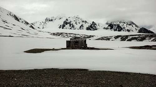
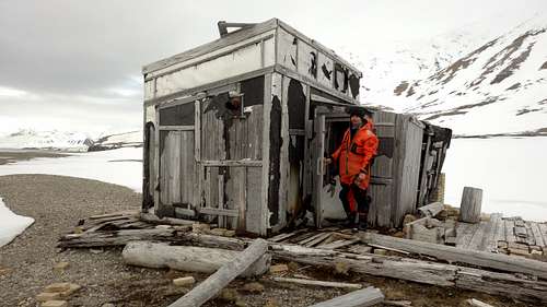
After arrival, you can sleep on the campsite: Hotellneset, Longyearbyen 9171, Svalbard i Jan Mayen, (watch out for polar bears! -> see section below) or in one of many hotels or B&B. The town itself is well stocked. Most of the goods are imported, which result in high prices. There is a grocery store and a shopping center. You can buy good quality sport equipment such as skis, pulka, down sleeping bags, warm shoes and snowmobile suit.

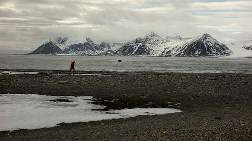
The only way to get nearby Hornsund fjord is to rent a boat or yacht. The journey takes 6-24 hours depending on how much money do you have. Easiest and safest way is to use local travel agencies. The shoreline of Hornsund fjord is highly diversified. There are skerries and shoals. There are a few places where you can touch land safely. In the period from November to May sea has an ice cover. There may be icebergs all year round. Glaciers discharging into the sea can be dangerous due to serac falls.

Polar Bears
According to the https://en.visitsvalbard.com/visitor-information/polar-bears :
"The polar bear – also known as the King of the Arctic – is one of the world’s largest carnivores. The polar bear population in the Svalbard archipelago and Barents Sea is around 3,000, which exceeds the human population. On www.miljostatus.no it says that «In August 2015, a survey of the Norwegian subpopulation estimated almost 1000 polar bears. Of these a little less than 300 were located in Svalbard – most of them close to the ice edge.»
The polar bear is considered a marine mammal as it spends most of its life on the drifting sea ice. Polar bear sightings are most common on the surrounding islands east of Spitsbergen, but you should be prepared to encounter a polar bear anywhere in Svalbard. Female polar bears give birth to their cubs in snow caves, and the cubs generally remain with their mother until they are around two years old. Their diet consists primarily of ringed seal, which is the most common seal species in the waters surrounding Svalbard.
POLAR BEARS ATTACK EXTREMELY QUICKLY WITHOUT WARNING. BE ACCOMPANIED BY A LOCAL GUIDE WITH A FIREARM WHEN LEAVING THE SETTLEMENTS.
Adult polar bears vary in size from 200 to 800 kg. Humans are considered alien in the polar bear habitat, and a polar bear may see us as potential prey. The polar bear is incredibly strong and even cubs weighing under 100 kg can be extremely aggressive and dangerous.
You can encounter polar bears anywhere in Svalbard all year round. Be cautious when moving outside the settlements and preferably be accompanied by a local guide. The polar bear has been protected by international law since 1973. It is considered a criminal act to hunt, lure, pursue, feed or disturb a polar bear. Anyone who blatantly violates this provision will face strict penalties."
if you have a permit, you can borrow a firearm for your own protection in Longyearbyen.
https://www.sysselmesteren.no/en/weapon/renting-firearms/
"Due to the polar bear threat in Svalbard, anyone travelling outside the settlements must be equipped with appropriate means of frightening and chasing off polar bears. The Governor of Svalbard also recommends having firearms with you.
It is forbidden to carry loaded firearms within settlement areas in Longyearbyen. The firearm should be carried so that everyone can see that there is no ammunition in it. You are not allowed to carry firearms in shops or public buildings."


Historical exploration of Hornsund
According to wiki:
The English explorer Jonas Poole visited Hornsund in 1610, giving the fjord its name after his men had brought back a reindeer antler.
in 1897, Sir Martin Conway accompanied by Mr.Garwood, crossed the glaciated area north of the Ice Fjord and ascended towards Hornsundtind massif. They had reached pass, named Conwaypasset.
First ascents around Hornsund fjord were made by "Deutschen Spitzbergen - Expedition 1938 ". Participants: Dipl.-Ing. R Bardodej (tourism), L. Gburek (geophysics), Dr. W. Pi llewizer (Photogrammetry, Glaciology), Dr, H. Rieche (preparation, management, hydrobiology, general morphology, tourism), Lecturer E. Steinruck (deputy head, warehouse management), M. Tiedemann (medicine, ornithology, physiology), E. G. Triloff (botany), P. Wegener (geophysics).
Hornsundtind 1st ascent - 27.07.1938 R. Bardodej L. Gburek H. Rieche. Probably through Gasbreen or Samarinbreen and South Ridge
Mehesten 1st ascent - 1938- unknown participants of "Deutschen Spitzbergen - Expedition 1938 " - traverse of arete
Mehesten 2nd ascent - 23.09.1957 Z. Jaworski J. Piotrowski. West Buttress and West Wall (IV. UIAA, French D)
Hornsundtind 2nd ascent - 27.07.1958 J. Piotrowski R W. Schramm A.Zawada . Through Garwoodbreen and South Ridge ("Normal route")
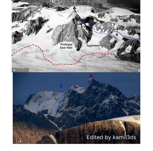
Hornsundtind 3nd ascent - 26-27.07.1959 M. Bała J. Stryczyński R. Śledziewski J. Warteresiewicz S. Worwa . Traverse through Northeast Ridge and Tindegga Ridge - also 1st ascent on Tindegga and Small Hornsundtind (2nd summit)
Hornsundtind ski expedition from Longyearbyen - 1997, M. Nilsen P. Strandhaug - 25 days
Hornsundtind 1st winter ascent - none, no info
Routes
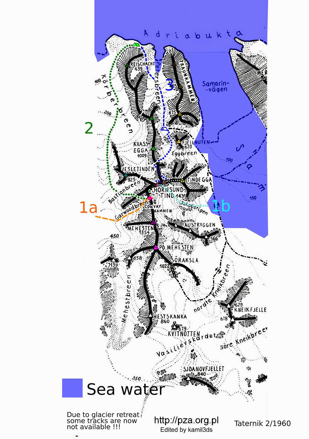
1a. "Normal route" - From Gashamna, Through Convaypasset and South Ridge/ South Wall (IV. UIAA, French D-)
Difficulties - mostly snow and ice. South ridge- south wall- traverse through gendarmes, exposition, ice and rock slabs.
1b. "East Route" - (IV-V. UIAA, French D+) Difficult approach, heavily crevassed glacier. Rock climbing on the south face up to V. UIAA
2. North-west route through Koerberbreen and Bastionen (IV. UIAA, French D-)
Lower part - mostly easy glacier travel. Bastionen - mixed traverse. Connects with 1b on the Convaypasset.
3. Traverse through Northeast Ridge and Tindegga Ridge - (IV-V. UIAA French D+)
Start point - Alpinistsletta. Follow the Petersbreen through pass, go down to Eggbreen, then ascent cole between Kvassegga and Small Hornsundtind. Upper part - According to Marian Bała- "snow, icy route leads to pass on Tindegga Ridge. Tindega - snow/rock up to III. UIAA. West ridge of S. H. - rock III. UIAA. Delicate traverse on the north side. Icy chimney (IV. UIAA), leads to an ice colouir and exposed ridge"
4. North Wall 700m average slope 70 degrees- unclimbed
5. East Wall - Tindegga 1000m average slope 65 degrees - unclimbed
6. Hornsundtind ridge- traverse of the massif - ?
7. Kvassegga ridge - unclimbed ?
Red Tape
Sør-Spitsbergen national park, Forlandet national park and Nordvest-Spitsbergen national park in Svalbard were established in 1973.
https://en.visitsvalbard.com/visitor-information
https://www.sysselmannen.no/en/maps-and-gps/thematic-maps/nature-conservations-areas/
When to Climb
Depends on conditions of the sea (ice pack)
Snow cover- november - may. equilibrium line altitude 350m.
Rock quality - average, permafrost and erosion
28 october - 9 february - polar night
23 april - 20 august - polar day
Camping
There are no official camping places in the area.
External Links
Add External Links text here.