Ted Hughes was an English poet and writer, much of his work is rooted in nature and of the mixture of beauty and violence in the natural world. Critics frequently rank him as one of the best poets of his generation and one of the twentieth century's greatest writers. – Wikipedia
Freedom?
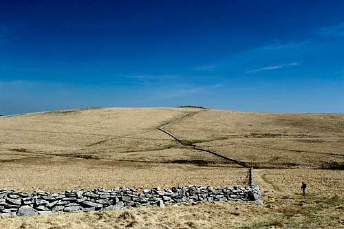
Looking south towards Postbridge.
The second national lockdown was coming to an end here in England and at last, we could travel around again – at least within the UK. Marie and I had booked 2 weeks holiday in Devon, a county in the southwest of the country. We had both been researching walks and places of interest to visit and a couple of days before leaving, we compared notes.
Marie had found a hike on the “Visit Dartmoor” website that explored the vast and desolate moors and included a crossing of a military firing range – where they frequently use “Live” ammunition – to visit a memorial stone for Ted Hughes, one of Britain’s greatest modern poets. To be honest, I knew little about him but Marie described his work as a celebration of nature and the natural world and that he was someone who could write beautifully about it. After some further internet research on the area, I was convinced this could be a really worthwhile outing.
After 2 days walking in Dartmoor around the hamlet of Postbridge, we were assessing our options. Dartmoor is famous for mists and low cloud drifting in across the rolling moors to obscure the route, soaking rain and wind are common and when you add the infamous Dartmoor bogs to the mix, things couldn’t get much worse!
Dartmoor
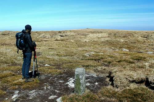
Postbridge, Devon.
The weather in April had been clear and sunny, if a bit cold and I thought that an attempt to find the memorial stone could be an excellent opportunity to test out my map and compass navigation skills that I hoped I still had. The route on the website started to the north of the moors, a bit of a drive for us around the small, local roads to find an unmarked parking area at the end of a track. We started to have second thoughts.
“It’s a shame we can’t start the route from Postbridge.” Marie said.
“It’s too far to walk from there.” I replied.
“Doesn’t look it.” She countered, looking at the map.
I looked over her shoulder, she was right. Although we probably wouldn’t want to follow the website walk from Postbridge, we could make up our own route to get to the memorial stone and back. After 20 minutes, we had come up with a plan. I went to bed that night excited to be exploring a new and wild area.
The next morning was bright and sunny again but the north wind was keen and at 3 degrees, it was even colder. We left the carpark at 9.25 am – I ought to say at this point that we had both seen a sign somewhere which said that the car parks were only open from 9.00 am – 5.00pm so we thought we had a time limit in which to complete the route which we estimated at around 12 miles – 20 km. As it turned out we were incorrect on the time limit, the car parks were open later.
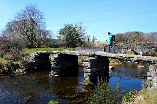
Postbridge has a 13th century “Clapper bridge” crossing the river which is where we started our hike before crossing the road and heading north on the footpath parallel to the East Dart river. We passed over Hartland Tor and continued on the familiar route – we had passed this way on the previous day – towards the distant Sittaford Tor, our first objective of the day.
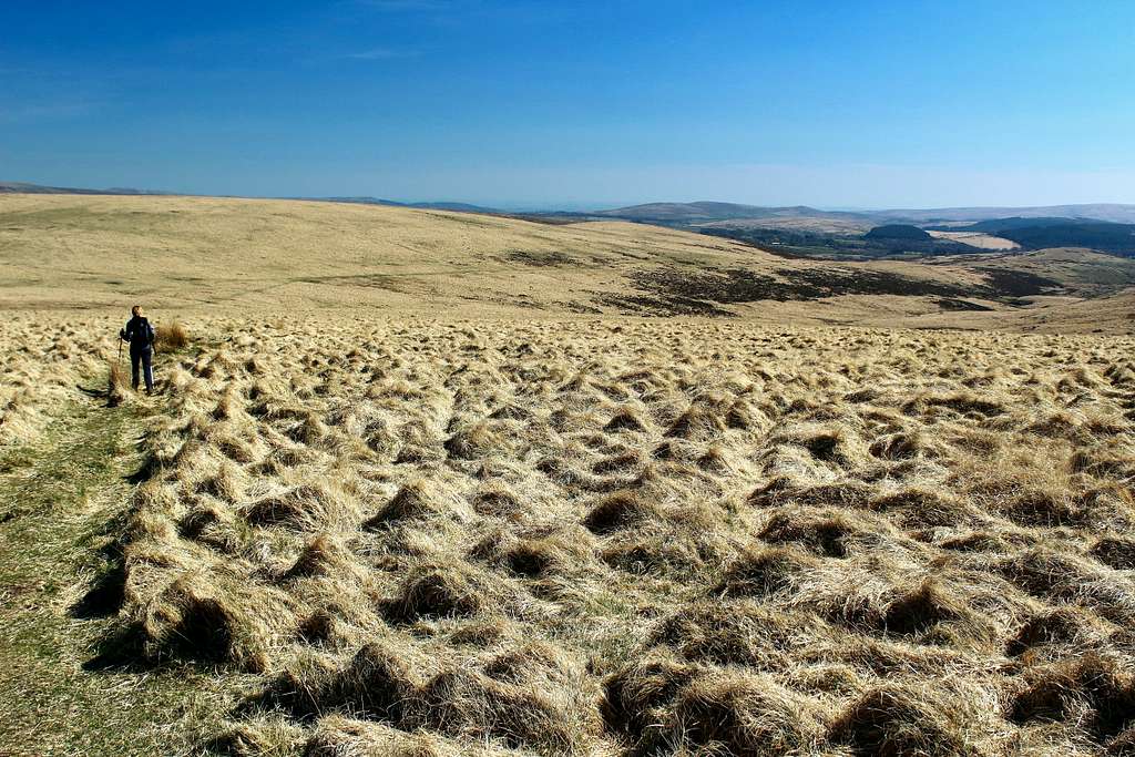
We made good time following the almost straight route, the moors looked lovely covered in golden grass, faded from its usual green in the unusually dry conditions. The addition of the blue skies reminded me of hot, late summer days and fields with haystacks.
We struck out uphill on an unofficial path to reach the top of Sittaford Tor by 11.00am. As we approached, a man left the Tor heading away from us. He was the first person we had seen so far that day and the last we would see for several hours.
Sittaford Tor, Devon (538m)
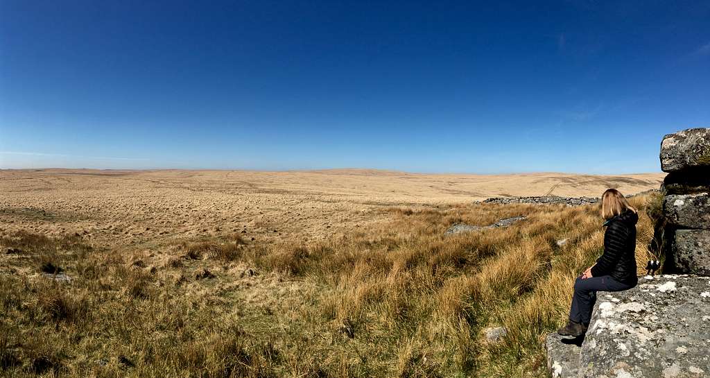
We drank some tea at the Tor as I studied the map and checked my compass bearing. Navigation should be easy in the clear, sunny weather and it had even warmed up enough for me to remove one of my layers. I lined the route up on the map and aligned my compass. The compass pointed me to the northwest across the moor, parallel to a long dry-stone wall for a way. As the wall turned to the north, our route continued on its original bearing towards “Quintin’s man”, a top marked on the map with a cairn. I could see a feint track crossing the moor towards the top. I couldn’t see the cairn but I could see 2 large cube – shaped objects, military buildings marking the entrance to the firing range.
We descended to the crossing of the North Teign river, at this point no more than a stream and set about regaining our lost height. My first reservation for the hike had been that we wouldn’t be able to cover enough ground quickly enough to complete the route but with the dry and clear conditions this was not an issue. The second reservation was whether my navigation skills were up to the task. Again, the clear conditions were a huge help although, I still took care, it would be easy to wander off in the wrong direction as we were both unfamiliar with this area.
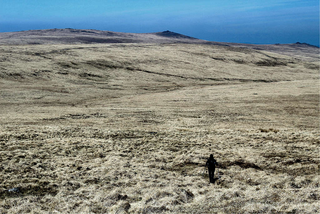
Quintin's Man, Devon
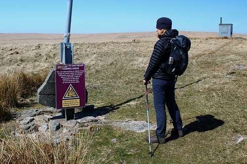
We reached the entrance to the firing range and paused to read the warning signs – no firing today, our research had been correct. We passed the cube shaped military buildings - very incongruous in this landscape and went on our way. Our route continued to the north, the feint path continued confirming to me that my route finding was still correct. We crested a grassy rise near the top of Whitehorse Hill and in the distance, we could see another of the square military buildings which I knew to be on the top of Hangingstone Hill.
At this remote point, we saw a stone memorial to Frank Phillpott. Phillpott was born in 1837 and he loved hunting and shooting, especially on Dartmoor. He was instrumental in creating “Peat passes” on the moor – the practice of cutting channels in the peat down to the granite bedrock – to help hunters and farmers to cross the wet peat moors.
I had read about these and had planned to take a “pass” heading east and downhill to pick up a path to take us back north again.
“Why don’t we just go across the top of the moor?” Marie asked. “We can see the building we are heading for; it will be quicker.”
Whitehorse Hill (590m), Devon
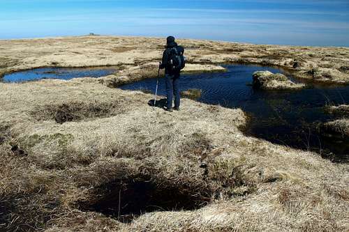
Crossing the bog.
It seemed a good idea, so we did that. Straight away we were off the beaten track and into a marshy area with dark pools of water.
“It reminds me of the Dead marshes from “The Lord of the Rings”, I said.
“Stay away from the candles, Frodo!” I said in my best Gollum - like voice as I stopped to take a photo.
Marie was unimpressed with my acting abilities but she had stopped. When I caught up, she pointed ahead to a small blue sticker on a metal stick in the mud.
“Do you think that means not to go that way?” She asked.
I thought for a second and said, “It looks ok.”
I stepped forward, planted my walking poles into firm ground and hopped onto what appeared to be muddy but solid ground.
This was a mistake, it was muddy but it wasn’t solid.
My foot went straight into one of Dartmoor’s infamous runny bogs and for a second, I felt that my foot was being sucked in!
Luckily, my momentum carried me forward and onto solid ground the other side of the bog. I ended up in a heap on the other side, muddy down one leg but ok and wondering what might have happened if I had gone right in!
” I’m going a different way.” Marie said as she walked carefully around the pit.
We continued, more carefully and soon reached the building on top of Hangingstone Hill at 12.30pm. We had arrived in plenty of time, I took my next compass bearing and we set off into the Taw valley, I figured we had a good 45 minutes to find the memorial stone before we needed to think about returning, it had all been easier than I had thought.
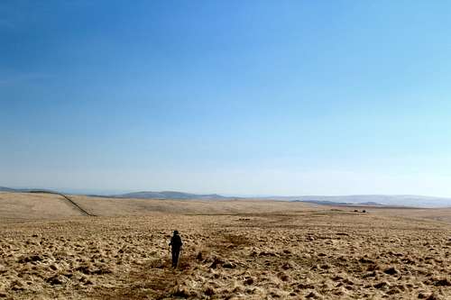
Taw valley, Dartmoor, Devon
Off the path, the going was harder, Marie followed an intermittent path while I tried to stay on the compass bearing. She stopped at a rock and turned around.
“This isn’t it.” She said.
I caught up, it was a long, rounded stone on top of another flat one.
“I remember this from the route description, it’s supposed to rock”, I said jumping on it’s top. It didn’t move but I was sure it was in the original route text.
I found 2 rusty, old (what looked like) Tank shells – a reminder of where we were. They may not have been anything dangerous but I didn’t touch them just in case!
We descended towards the shallow valley bottom, the source of the River Taw. Marie went one way and I went a different way, trying to stay on course but also, trying to avoid spraining an ankle on the rough, tussocky grass or the soft bog.
Backwards and forwards across the valley we went.
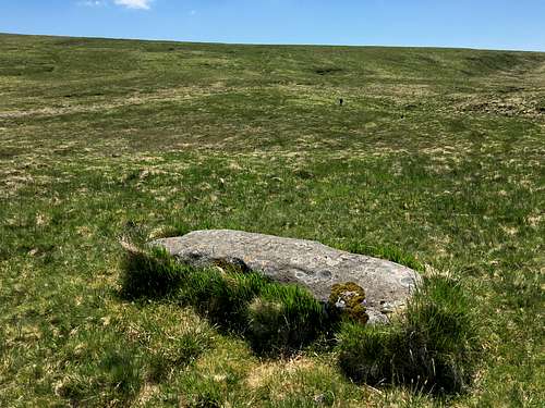
Not only could I not find a memorial stone, I was struggling to find any rock at all. Every now and then one of us would find one only to be disappointed it was not inscribed!
The memorial stone apparently lies sunken into the turf, the inscription viewable from above.
I had worried we wouldn’t actually make it to the valley. If we did, I assumed we would see some rocks and find the correct one. Now, for the first time, it occurred to me that we might not find it! Even if my map reading had been perfect, it would still leave us a 100 metre square to search.
We wandered back and forth and time ticked on.
By 1.15pm we decided to call it a day and head back to Hangingstone Hill. I kept glancing over my shoulder, as though suddenly the memorial stone would be obvious but we never found it, I couldn’t believe it. So close but so far!
We re-traced our steps and sat in the lee of the military building to eat lunch. Here on the west wall, we were out of the wind and in the sun. As we ate, a figure appeared from the west, he waved and continued eastwards – the first person we had seen for 3 hours.
We finished lunch and got ready to leave just after 2.00pm, 2 men appeared from the north east and said “hi”. We saw no one for 3 hours, then 3 people in 15 minutes.
We contemplated crossing the boggy ground to get back to Whitehorse Hill, it did not look promising.
“Is that a path over there?” Marie said.
I lined up my compass and checked the map.
“I think that’s the path we should have been on before.” I said.
We decided to take it and headed southeast, then met Phillpott’s peat pass which took us back west to the Phillpott memorial stone we had seen earlier, much easier this way!
Okehampton firing range, Dartmoor, Devon
I took a compass bearing and we headed across the moor. I squinted into the sunlight and in the distance, I could make out the tiny, cubed military buildings on the edge of the firing range, silhouetted against the golden grass and afternoon sunlight.
The perfect conditions meant we arrived quickly and passed on to return to Sittaford Tor for an afternoon tea break at 3.00pm.
We slowed down as we completed the last stretch of the walk to arrive back at the car park at 4.30pm. It had been a great day in a fantastic wilderness but ultimately, we felt disappointed to not have found the Ted Hughes memorial stone.
Sittaford Tor (538m)
Back home, I did some more internet research.
Although Hughes was born in Yorkshire, he fell in love with Devon and moved to the “soft south” (of England) and lived there for 40 years. When he died, his ashes were scattered near Taw head, the source of the River Taw in which he loved to go fly fishing. He also asked for a memorial stone to be sited in the same place. This part of Dartmoor is owned by the Duchy of Cornwall (Prince Charles), so special permission was required to site the memorial stone here. The memorial stone had remained a secret for 2 years before being accidently discovered by walkers in 2003.
I had no idea there was so much information available about it. There are many accounts describing how to get there, how various people have done it and how many people think it’s not as special now that everyone knows about it! A number of people have struggled (like us) to find it, one searched for 2 years. We will definitely return for another go.
Update: Found!
Ted Hughes memorial stone
Resting for a moment in the warm sunshine on Sittaford Tor, our peace was disturbed by a series of short, sharp, distant thuds.
We both looked up and towards the horizon, then looked at each other.
“What was that?” Marie asked.
“Gunfire.” I replied.
“Not today,” she said. “Have they changed the schedule?”
Marie got her phone and started to look for the firing range website but I already knew the answer.
“No, the Okehampton range is open today, it must be from one of the other ranges.”
“How do you know they haven’t changed the schedule?” She asked again.
In reply, I nodded towards the northwest, on to the other side of the valley, approximately 1 mile away.
“No flag.” I said.
The warning flag on top of Quintin’s man was not flying, which meant the army were not using the area for practice that day.
“It must be one of the other ranges.” I continued. “Only Willsworthy is being used today.”
“Surely, we wouldn’t be able to hear it from that far away?”
“I don’t know, gunfire is loud...” I said as though I knew something about the subject.
“…especially the guns the army uses!”
Having returned home in April, Marie and I had not expected to go back to Dartmoor for the foreseeable future. I had written the above trip report and had planned to post it on SP. However, before I did, a number of unexpected events had created an opportunity for us to return. In mid – June, the weather was warm and settled and we were determined to find the Ted Hughes memorial stone at our second attempt.
I couldn’t help but compare our second attempt to the first one.
We left Postbridge about 10 minutes later than on our first trip but by the time we reached Sittaford Tor, we had already gained about 30 minutes. We had a shorter break and crossed the valley to the Okehampton range entrance at Quintin’s man, then continued on towards Whitehorse Hill.
When we had been there in April, it had all seemed a very wild, barren place. I was worried that my navigation was not up to scratch and we definitely didn’t want to become any of those people that get lost on the moors!
Now, it was still wild and barren but also seemed familiar and beautiful and I wasn’t worried that we would get lost at all.
We headed from Whitehorse Hill towards Hangingstone Hill – I didn’t need to check the compass bearing, we found the way from memory and by following the feint track – and picked up Phillpott’s peat pass around the bog and up to the military building on top of the hill.
We arrived at about 11.40, 50 minutes earlier than before, even though we left later!
“How did we do it so quickly this time?” I wondered.
Marie had several suggestions. “It’s warmer so our packs are lighter, we didn’t stop for so long on Sittaford Tor, you are not spending so much time looking at the map or taking as many photos as before and no one fell into a bog this time!”
I took a compass bearing from Hangingstone Hill to where the stone was meant to be cited in the Taw valley (in my research, I found that different writers had cited it on both the east and west banks of the River Taw), we both checked it and started to descend into the valley, this time keeping strictly to the bearing.
Previously we had tried to find an easy way down, now we took a direct line over the mixture of bog, grassy tussocks and animal tracks. This ground is really hard going and there is a danger of injury especially from stepping in the holes between the tussocks of grass. Slowly, we descended. Up ahead on my compass bearing, I could see two grassy mounds. The left one seemed to be directly on the bearing whilst the one on the right was just off. We knew the stone was on the top of a mound.
Marie went to check the left mound while I went to the right one. I soon realised that my mound was just a shoulder of a larger mound. I looked towards Marie, she was struggling to find a way through boggy mud, to cross the river. I looked ahead of me and glanced at the compass, now the larger mound in front of me was directly on the bearing.
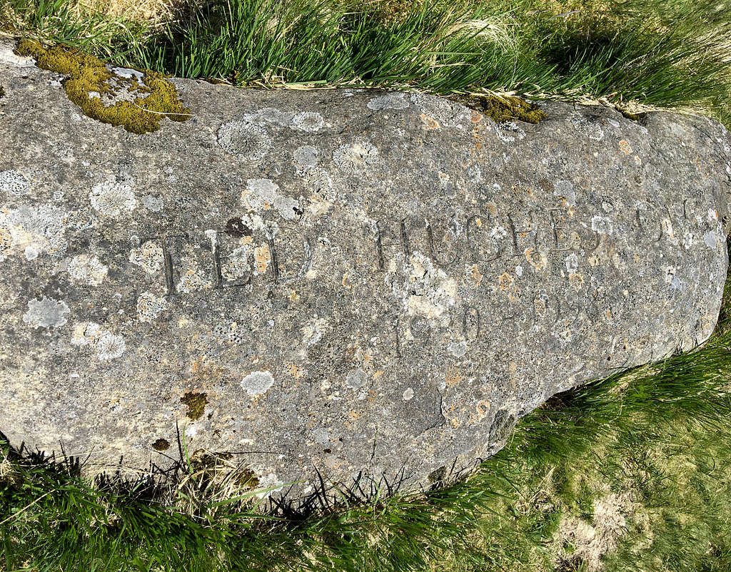
I continued on, up ahead was a rock protruding from the turf. As I neared it, I was disappointed, there was no inscription on the top. I took a few more steps towards it. And then - as if I had uttered some Tolkein-esque spell – an inscription appeared!
I walked up to it and read “Ted Hughes OM …1930 – 1998”
“MARIE!” I shouted and waved.
Ted Hughes OM 1930 - 1998
Isn’t it typical? Last time, we spent 45 minutes searching for it in vain. Looking around from on top of the mound, I think I had walked within about 30 feet (10 meters) of it before but not noticed it. This time, we had found it straight away!
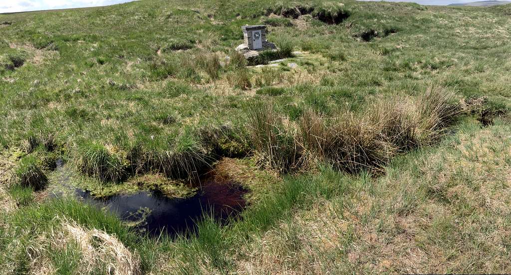
Bonus - The Cranmere pool
After taking several photos, I sprung a surprise on Marie.
“Actually, we’re still quite early.” I started. “Instead of just going back, how about trying to find the Cranmere pool?”
Marie thought for a second, then said “Yeah, OK.”
The Cranmere pool lies at West Okement head, the source of the West Okement river.
Back in Victorian times, a local guide used to take tourists across the moor to the pool where he had left a jar for postcards. Nowadays, the pool has nearly dried up and there is a brick built box, a feature in the empty landscape of the moor, containing a unique rubber stamp, to use as evidence that you have visited the spot. Again, it’s a good test of one’s navigational abilities.
I took a bearing and we headed off, once again moving slowly through the tussocky and even more boggy landscape. It was slow going, difficult to see much in the flat landscape and I had started to think we wouldn’t find the pool. If my compass bearing had been even a little bit off, we could have walked past it without noticing.
“Are we still on the bearing?” Marie asked.
I nodded. Up ahead, I could see a depression in the moorland. If the pool is at the head of a river, may be this is it, my thoughts told me.
Suddenly, I could see a small construction up ahead, strangely out of place in the barren landscape. I was bang on!
I stamped my map, signed the register and took the obligatory photos. Sadly, there is not much of a pool left, just a puddle really!
We headed back to Hangingstone Hill. I took a compass bearing but we could see the military building clearly from a mile away. After that, we retraced our steps back the way we had come to the car park at Postbridge. A few clouds had appeared as the afternoon had progressed but it was still lovely to be out on the moors.
We arrived at our destination at 5.30 pm. A round trip of 22 Km. (13.75 miles)


Comments
Post a Comment