
-
 17536 Hits
-
 88.19% Score
-
 26 Votes
|
|
Custom Object |
|---|---|
|
|
45.45315°N / 13.84758°E |
|
|
Istria Waterfalls |
Intro
Posting Istria, I have a little trouble. First, I like that area as much as my home mountains. It's so different! On the other hand, it's not really a mountain area. Am I justified to put it on SummitPost at all? If you visit the excellent Dinaric Alps page, you will see that the western part of Istria penninsula is excluded from that big mountain range. It's geologically different and so does not belong to any big mountain grupation - not to Dinarides, neither to Alps, neither to Appenines. But again, Istria is also in this part so great for hiking and biking, so attractive that many people visit the region regularly, despite living hours of drive away.When thinking about reasons why we are visiting so often the Istrian areas outside Čičarija and Učka, and which activities they offer, being the subject of SummitPost, I realised it's only hiking along river and creek beds and visiting waterfalls. The rest is biking and driving around, visiting rich cultural heritage of Istria, which is out of the SummitPost scope. That's how the idea for this page emerged. And due to reasons mentioned above, I'm attaching it to the Dinaric Alps only as 'related' - due to the geographical proximity.
Overview
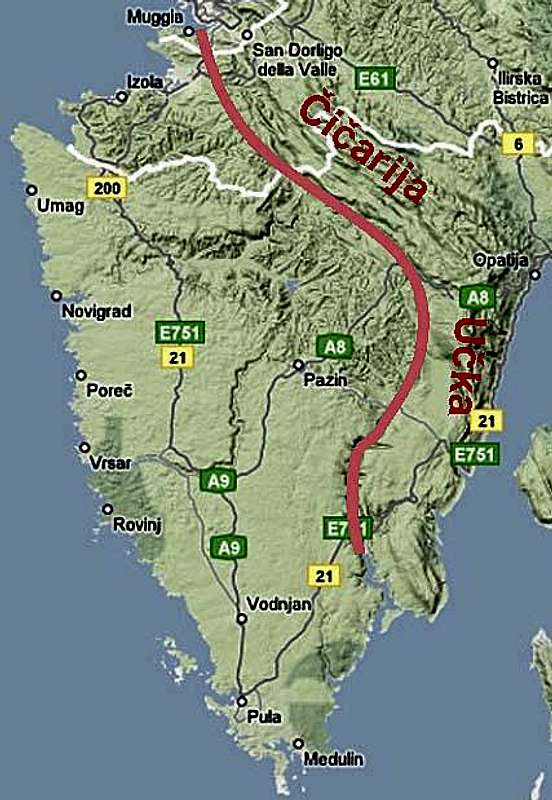
The division line between Dinaric Alps and the hills of central Istria
On the SW slopes of Čičarija and the W slopes of Učka there are no longer flowing waters. All the water disappears into the karst terrain and comes on the open air on the border with flysh zone - roughly close to the red line on the map. In the hills of the central Istria also other rivers and creeks have sources. Over the flysh terrain they are flowing above the ground, then some rivers make their way till the Adriatic sea (Dragonja, Mirna, Raša), while many creeks disappear in the karst terrain ow the western Istria (for example on the plateau between Buje and Zrenj).
Creeks and rivers, flowing by the flysh terrain form waterfalls on many places where big harder rock blocks are inbuilt in flysh. So, it can happen that on low altitudes, in the middle of a broad, fertile valley, there's a step, where water is falling tenth of meters over the abyss.
 Istrian scene Istrian scene |  A waterfall in ravine A waterfall in ravine |  Sv. Kirik Sv. Kirik |
Dragonja

'Dragon line'

Near Dragonja
Along the lower part of Dragonja there's the road, fields and orchards. The nature is not much special. Near the village Dragonja, there's a limestone island rock, which is special due to its endemic flora. A short, 30 minutes walk by its upper edge and a return below should give you a good impression of the place.
Soon afterwards, walking upwrds, from the south Argila/Paganja creek joins Dragonja. It has a nice waterfall, which will be described later. At Škrline, the place where Pinjevec/Rokava joins Dragonja, the lower part of the valley ends. While this popular place can still be reached by a few roads, the part upwards is much abandoned. I still remember how in a bad, dark weather we first hiked on from this place. A sense of solitude was so strong, that I was even a bit scared. On a warm, sunny day the feeling can be much different.
From Škrline, upwards the river flow, you can hike by abandoned cart-roads and paths. But doing so, you will miss most of Dragonja beauties. That is why we allways, really no exception, there start wading the river. Good clogs and poles are welcomed for that. Doing so, wonderful places are densely lined up: 'Dragon lines', picturesque grey flysh walls with deep ponds below them, nice meadows, a vivid river with picturesque cascades, many lonely places to have arest on the sands or rocks or to take a bath. The first March annual bath there became almost a tradition. The Dragonja hike will not be a quick one, the biggest mistake is to speed up there.
 On Dragonja On Dragonja |  Dragonja cascades Dragonja cascades |
Depending on time you will pass the inflows of many creeks and finally exit the valley by one of the old cart-roads or paths. To return back a bicycle or second car is worth inbuilding into the hike logistic.
A Bike & Hike Proposal
Leave bikes in Boršt village and drive your car to Škrline. From there wade Dragonja till the inflow of Vruja creek. Close there is a house of a man, named Šav. There it is not hard to find a cart-road up to Boršt village. Altogether some 3-4 hours, some 300 meters of altitude difference.

A crab in Supot creek

Supot
Supot Waterfall
East of the ridge on which the well known and nice Koštabona village lies, towards the south Supot creek flows towards Dragonja. On the upper part it has a nice waterfall, but you should visit it when the creek has enough water. The only thing hindering to enjoy the place is a dense vegetation. Due to it going down by the creek is supposedly very hard, if not impossible. On the lower part of Supot creek, where the cart-road comes into the valley there's another, smaller waterfall, which we haven't visited yet. That the water of Supot creek is very clear prove the creek crabs which are still living there.
So, the upper waterfall can be best reached from Koštabona, where we take a cart-road descending gently towards the NE. We reach the waterfall in some 20 minutes.

Stranica

Stranica
Stranica
The highest waterfall in Slovenian Istria is near Trebeše village. Also that one should be visited when Stranica creek is having enough water. The ravine is being intermitted by a huge rock block, over which also a path goes. Don't go too much on the edge, the waterfall altitude is 20 meters! Otherwise you have a nice view on the waterfall from the path, or from below, if you descend into the ravine by the right side of the creek.
Stranica waterfall can be reached either from Trebeše village or from Pičuri farm, on the other side of Stranica valley. Both approaches are marked. From Trebeše we can follow a weak cart-road, from the other side only a tiny path comes.
Hiking down by Stranica creek can be a challenge itself. On Stranica there are no more bigger waterfalls, but the valley is nice. If you decide to hike down till the inflow of Stranica into Dragonja, perhaps skip the part just below the big waterfall (due to dense vegetation). Go a few minutes up towards Trebeše and then take an even weaker cart-road descending towards the creek. Below, the path soon disappears, reappearing again after the inflow of Grdi potok into Stranica.

Grdi potok - lower

Grdi potok - upper
Grdi potok
Grdi potok is a left tributary of Stranica. Just above the junction it has a nice waterfall with a pond, higher there is another, smaller waterfall, being upbuilt with an artificial dam. The area is very remote. And finally, on the left tributary of Grdi potok, soon below Sirči village there's another small waterfall, being almost never visited.
A Hike Proposal
Leave your car on the last curve before Pavliči, a village below Sirči. Red and blue marks follow the weak cart-road towards the right. Later it turns into a path, which reaches Grdi potok (and exits on the other side of the valley again on the road). Now go by the right side of Grdi potok down. The pathless terrain or at best a tiny path brings you to the junction of Grdi potok and Stranica. Go up by Stranica if you want to visit also the big waterfall and then return. Go down along Stranica creek. The path is crossing the creek several times. When reaching Dragonja, turn left and go almost till the old Mazurinov mlin (mill). Just before it find a cart-road (marked) going left upwards towards Pavliči. Above leave the cart-road and follow the marked path till the village. Some 4 hours, 300 meters of altitude.
Vruja
Vruja is a creek, coming down into Dragonja from the vicinity of Belvedur. Its waterfalls are rarely described and photographed. The reason is probably a pathless terrain and a dense vegetation in the valley. So, if you want to visit those pearls, a good portion of fighting with thorn plants is inevitable. The area is again almost a true wilderness. And a good advice - visit the area in the afternoon, when the sun reaches into the ravine.
Cute is already the inflow of Vruja into Dragonja. As if the creek was not willing to inflow in an ordinary way, but had to jump vividly. In the nearby Dragonja ponds there are some nice options to take a bath, prior to start the hike. At fist we shall be probably able to follow a tiny path, otherwise we must find best passages through the vegetation ourselves. Soon we arrive to the lower two waterfalls. Thea are 'classical' ones - a strong barrier of harder rock is resisting water erosion.
A bit further on a nice surprise is awaiting us. The lower cascade on Vruja is one of more beautiful creations of Nature in the Slovenian Istria. The thing is neither high, nor mighty. Five steps, joining in a wide angle, but the weater is flowing only over the right part, where it made over the steps a layer of flow stone. A cute scene, especially in autumn, when the rocky are covered with golden leaves, or in spring, when the cascade is surrounded by a fresh grenery. These cascades can be reached also by a tiny path, coming from the left (looking down by the creek), from the old cart-road, descending from St. Hieronim into Dragonja valley (see later).
 Lower waterfall Lower waterfall |  Cascades on Vruja Cascades on Vruja |  Upper waterfall Upper waterfall |
Above the cascades the ravine continues similarly. Some more similar scenes await us, but the cascades are not so picturesque as the first one. We scramble the ravine with more and more difficulties. But it is worth going on, as above another interesting waterfall is awaiting us. High, all covered with flow stone stops us just on the place where steep walls close the ravine. When we approached the waterfall one autumn, suddenly a big mass of rocks fell down into the pond. Even so, everything in the surroundings looks so crumbly and fragile. Take some care though. We detour this waterfall by the left side (looking up), the ravine slopes are pretty steep! Above the ravine continues quite some time. Even if there are no more waterfalls, in the upper part the creek bed is interestingly all covered with flow stone. As it is not too steep, we can proceed by it. Above that part it looks that interesting places are over, so we need to decide to exit the ravine.
Ravine exits in Istria are many times kind of uncertain. You can't orient at all, when approaching settlements on ridges, you usually need to climb from one terrace on another. Paths are no more there, terraces are abandoned, only stone walls prohibit to ascend further. It took us quite long time to exit Vruja ravine, fighting with thorn plants, searching a routhe through a dense oak forrest. Luckilly it was a golden autumn and we were all surrounded with fairy-tale colours. Finally we reached the clearing below Žrnjovec and belvedur is not far away.
 Vruja forrest Vruja forrest |  Like in a parc Like in a parc |
A Hike Proposal
Park in Belvedur. Walk down through Topolovec village and by the abandoned church of St. Hieronim down into Dragonja valley. Then righ by the river till Vruja creek inflow and as described above all the time up the creek. From the top of the uppermost cascades left through steep and dense woods (pathless) and abandoned terraces into Žrnjovec village and up to Belvedur. 3-4 hours, some 300 meters of altitude difference.
Pasjak
By Pasjak creek the border between Croatia and Slovenia goes (and today a Schengen border of EU). Usually only the lower waterfall on Pasjak is mentioned and visited. It could be heard that above there are some more. But is the ravine passable? Can one detour waterfalls? We did a try and it paid off! As Vruja, also Pasjak should be visited in the afternoon.
We already know the path from Belvedur down to Dragonja river. The inflow of Pasjak can of course also be reached by other paths. We start the hike up the creek. At first we can find a weak trail on the right, where we can also see the rests of some anciant mills. Then we follow the creek bed and soon reach the lower waterfall. It is really picturesque. The strongest impression makes a powerful rock barrier which will resist water for many following years. Very picturesque is also the surrounding of the waterfall. The ravine below it, bizzare tree branches, the passage behind the waterfall. A still good path ascends on top of the waterfall. And there a nice surprise awaits us - a tiny path continues.
 Lower Pasjak waterfall Lower Pasjak waterfall |  Lower Pasjak waterfall Lower Pasjak waterfall |  Lower Pasjak waterfall Lower Pasjak waterfall |
The ravine is nice and wide, the creek bed beautifully paved with regular stone cubes. Along a vivid creek you have a nice walk-up till the next waterfall - a true monster, made of flow stone. From a shallow pond a broad, brown flow stone curtain is rising, almost entirely closing the whole ravine. This flow stone waterfall is detoured without major problems by the left side (looking up) and above it the scenery is much similar. The scenery is most surprising. When you reach on top of the next flow stone cascade you can see along the creek at least four more cascades or waterfalls. The perspective does not allow you to judge that the last two waterfalls are quite high - some 10 meters or more. So the surprises follow one after another. Finding passages makes you no major problem. They are allways on the left side (looking upward).
 The scenery The scenery |  On Pasjak creek On Pasjak creek |  The uppermost Pasjak waterfall The uppermost Pasjak waterfall |
Above the last waterfall in this series we soon hit on an old cart-road, entering the ravine from the left, Slovenian side and continuing on the right, Croatian side. Today certainly no one uses it! My advice would be to use that cart-road towards the left. It certainly comes on the ridge, which descends from St. Hieronim down towards Dragonja river. But as we were curious if above the ravine of Pasjak hides more surprises, we continued upwards. But there was nothing so special. The ravine becomes more flat and as after some 200 meters there were no more cascades we decided to exit the ravine towards the left, Slovenian side. Again the same story - dense, steep forrest, abandoned terraces, even when we reached the electricity clearing, we didn't know whether to go left or right. We went up and then left, finally reaching St. Hieronim church.
A Hike Proposal
Park in Belvedur. Walk down through Topolovec village and by the abandoned church of St. Hieronim down into Dragonja valley. Then a bit left till the inflow of pasjak creek and as described above, all the way up till above the last bigger waterfall. Exit the ravine by the cart-road towards the left. You should reach the marked path and follow it right up till Hieronim church.

Paganja/Argila waterfall
Paganja
The last left tributary of Dragonja has its sources below Momjan, then flows some time over the plateau below this town and near Fineda hill suddenly decides to jump over the rocky step into Dragonja valley. The waterfall is rarely visited. Due to the border between Croatia and Slovenia, which is here on Dragonja river, the ascent from below, from Dragonja is not recommended until Croatia joins European union in a few next years.
A Bike & Hike Proposal
Leave bikes on the road below Momjan, where you will near Fineda hill exit the Paganja gorge trail. Then drive towards Kaštel and leave your car on the curve before the settlement. The path goes over Kras, a slanted plateau, leaning slightly towards Dragonja valley. If you follow the right path, it is comfortable and with only little descent it brings us almost horizontally to the picturesque waterfall. On its western side there are interesting caves. From there we need to descent, cross the creek below the waterfall and find the path on the other side. By it you steeply ascend on the plateau below Fineda hill. Go also just on top of the waterfall, where the creek falls over the rocks. Then find your bikes and return to the car.
Reka
Reka (means: river) is a creek, flowing from the central Istrian hills on the opposite side as Dragonja (towards the SE). Below, on the Croatian territory it is called Bračana and inflows Mirna river. Close to the border, on the Slovenian side, there is a nice waterfall, called Veli vir. It is reached by a marked tourist path from Sokoliči village. But upwards the Reka creek almost nobody goes. There again the landscape returned into a true wilderness. These places must be visited early in the morning, when they still receive sunshine.Below Veli vir there is a big pond, almost a small lake. Standing there and admiring the powerful rocky barrier, you start thinking how to come up there. The most prosaic option is by the detour path on the right (looking upward). But you can also climb the waterfall rocks on the right side. It is not hard, nor dangerous. Soon you can sit on the rock wall, with legs, dangling over the abyss.
 Veli vir Veli vir |  Above Veli vir Above Veli vir |
Above the waterfall you are soon submitted to the dense vegetation. You wade the creek, occasionally try to follow tiny paths on each side, there are also a few places to refresh in the ponds, some of them made by small artificial dams in the distant past. After the only (abandoned) cart-road comes into the ravine, the creek branches. I think there we followed the left branch (looking upward). Then orientation poses no more problems, but wilderness is harder and harder. But do continue as above a special waterfall awaits you. We named it 'Podkvasti slap' (Horseshoe Waterfall). It is one of the most beautiful artistic creatures of nature in Istria, made of thousands flysh plates. Sadly only that it rarely has enough water - we are already high up the creek.
 Podkvasti slap Podkvasti slap |  A flysh slope A flysh slope |
We detour the waterfall by the right side (looking upward), the passage is wery steep. Above we can still some time follow the creek bed, but rocks in the ravine get more and more unstable, on one place we need to cross a very steep flysh slope, above which we already suspect the two old Venetian towers, and anyway we know that the ravine would bring us only below the big abyss, where it ends dry, without any waterfall. So we turn back in order to exit the ravine before the steep flysh slope towards the right (looking upward). We take another shallow ravine, steeply scramble upwards and finally throughe a dense forrest reach a humble field. Along it we proceed upwards and left on the ridge with two old Venetian towers. They are in a very bad shape today, but centuries ago they were used as a fortification on the Venetian state border. From the towers a marked path goes up by the ridge and in some 10 minutes we exit on the road by Pičuri hamlet.
A Bike & Hike Proposal
Leave bikes on the road by Pičuri hamlet, where the marked path goes down towards the two old Venetian towers (one of them is seen on Google Earth map!). Then drive with your car down towards Sočerga, but detour before on the right and drive down to Sokoliči village. From there hike down by the marked path to Veli vir. Continue the tour up the creek as described above. After you exit near Pičuri, bike down to your car. 2-3 hours, some 250 meters of altitude.
Šterna

Near Šterna village
Mirna

On Mirna

The mill in Kotli
A Bike & Hike & Wade Proposal
Leave your car near Buzet town, close to the place where Mirna river exits the upper valley and approaches the town. Then do a nice bike tour by a good road up to Dragučtown, continue towards Grimald (visit it), bike down to Cerovlje and bike along the main road, using local roads, towards the nort. Finally bike up to Hum, the smallest town in Istria. Continue towards the north by the main road, but in the middle of it deter left and descend steeply down to Kotli hamlet. Leave your bikes by the restaurant. There start wading Mirna river. On some places it is deep enough, so you need to exit on one or the other bank. Continue all the way down to Buzet, where your car is waiting. Drive in Kotli to pick up your bikes.
Butoniga
Contrary to the NW part of Central Istrian hills, the SE part has a horseshoe shape with an artificial lake in the middle. Butoniga lake is a reservoir of fresh water for the whole Istria and so a protected area. A few smaller creeks are flowing into the lake, the Butoniga creek has two nice waterfalls, certainly worth of a visit. You can do a hike there, but both waterfalls are also reachable by a road, coming into the valley from Pazin (from the SE). Especially the bigger of two waterfalls is beautiful, it offers also the experience of walking behind the water curtain. Make sure to visit Butoniga waterfalls when they have enough water. The small waterfall on Butoniga The small waterfall on Butoniga |  The big waterfall on Butoniga The big waterfall on Butoniga |
Sopot
One of the most stunning sceneries in Istria is almost nowhere mentioned as a natural beauty. Tourist guides are missing to mention Sopot, in books about Istria there are no pictures of it. And yet it is some 30 meters high (the highest in Istria) and very beautiful, be that we are admiring it from above or from the small lake below it. The reason of being so neglected could be only one - I guess that most of the time it lacks water. But if you come let's say in April, or after a heavy rain, the visit will certainly pay off. Also Sopot can be approached by car. From Floričići, a small village SE of Pazin (near Pićan) you have only some 5 minutes walk to the waterfall (marked). A small creek is flowing by a wide valley. Suddenly a limestone wall opens below and the water falls deeply down in the abyss. Just above the waterfall an old bridge crosses the creek bed. Once the road over it was connecting the town of Pićan with the central Istria. In a nice day a pleasant marked hike can be warmly recommended. It is called Sveti Šimun path. We can start it above, in the panoramic village of Gračišće, walk down to the waterfall and then around the eastern side of the valley back up. Nice hamlets, the waterfall, the cute church on Škopljak are the highlights. Sopot from above Sopot from above |  Sopot Sopot |
Zarečki krov

Climbing
This wonderful place is easy to find and you can reach it by car also. If you are coming from Rijeka direction - leave the motorway on Pazin - istok (east) exit and drive towards the town. There are two right turnings on a straight, flat part of the road after passing under the railway bridge. Both of them lead to Zarečki krov waterfall.
 Zarečki krov Zarečki krov |  Under the 'roof' Under the 'roof' | 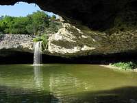 Inside a half-cave Inside a half-cave |