
|
|
Area/Range |
|---|---|
|
|
29.00000°N / 96.00000°E |
|
|
Hiking, Mountaineering, Skiing |
|
|
Spring, Summer, Fall, Winter |
|
|
The Kangri Karpo Range
The Kangri Karpo mountain range stretches about 280 km from nortwest to southeast. It is situated in East Tibet between the Parlung Tsangpo in the north and the Lohit Chu and Kangri Karpo Chu in the south. The eastern end of the range forms a high plateau, while the western end leads into the valley of the Parlung Tsangpo which becomes a forested deep gorge. In the southern side of the range, the valleys are extremely eroded, and towards the north topography is rather complicated with glaciated valleys. Kangri Karpo Range
 Ice on Lhagu Co
Kangri Karop range several peaks over 6000m, the majority of them are still unclimbed. The highest peak is Chombo (Chinese names: Ruoni or Bairiga) reaching an altitude of 6882m. It is located in the southeast of the range. The most prominent peaks in the western part of the Kangri Karpo range is a group of five peaks over 6000m around Kone Kangri (6347m).
History of Exploration
The first information about Kangri Karpo range was brought to the Western world by the Pandit A-K. In 1882 he had traveled from Zayul up the river Kangri Karpo Chu and crossed the Ata Kang La (4610m) and proceeded to Rawok and on to the Tibetan High Plateau. one of the Kone Kangri peaks
In 1933 the botanist Francis Kingdon-Ward set off from Sadiya of Assam with Ronald Kaulback and traced A-K’s footstep to Ata Kang La. Kingdon-Ward continued his trip northwards to Rawok and went further to the north to search for the upper Salween River. Kingdon-Ward made a preliminary survey of Ata Glacier and for the first time recognized the highest peak, Chomo (6882m, Chinese names: Ruoni or Bairiga).
In 1935 Ronald Kaulback accompanied by J Hanbury-Tracy came back to explore yet undiscovered regions in Salween upper basin. After they had explored the
southeastern side of Kagri Karpo range, Kaulback traveled along Kangri Karpo Chu
Qu and Tracy went down along Parlung Tsangpo.
The Chinese Academy of Science had carried out a series of scientific surveys of the eastern part of the Kangri Karpo range in the 1970s. Ata Glacier and Lhagu Glacier were scaled in this context. In 1989 and 1990 the Chinese investigated Medoi valley in the central part of the range not far from Rawok.
Today, major peaks of the Kangri Karpo mountain range are still unexplored and unclimbed. Japanese climbers have carried out a number of reconnaissance expeditions in the 1990s and early 2000s to Lhagu Glacier, Ata Glacier and within sight of Bairiga, the higest peak. Japanese climbers also have carried out reconnaissance expeditions to the Kone Kangri peaks, but all peaks still remain unclimbed.
Getting There
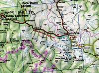 Kangri Karpo Range
External Links
High Asia, a commercial operator offering custom expeditions in the area (the link is just for information, I have NO experience with the company).
 Unknown peak Unknown peak |
 Another unknown peak Another unknown peak |
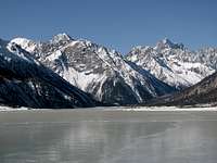 Rawok Co and mountains Rawok Co and mountains |