
Comments
No comments posted yet.
August 9, 2014
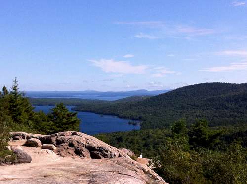
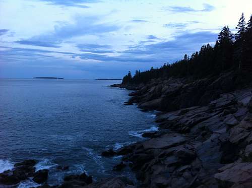
We arrived at Acadia NP last night, and it has been a beautiful experience so far. We drove the park loop road today, stopping for a hike up the South Bubble. We also took a drive up Cadillac Mtn, a nature walk in the demonstration gardens, and a quick dip in the cold(!) North Atlantic. We spent the afternoon searching the tidal pools along the rocks of Otter Point and Western Point.
On the way out East, we spent a lot of time cooped up in the car, and spent a kind of icky night in a kind of icky motel in Holiday City, OH. Seriously--it was like something out of a Cormack McCarthy novel. The second night out, our sleeping accommodations were at the lovely campground in Thompson's Lake SP just outside of Albany. In two days, we light out for Katahdin and the first highpoint of the trip.
Came up from Acadia to Baxter SP today. It was an easier drive than we expected, and we arrived at the Abol campground at about 1:30 pm. I had received notice about the Abol trail being closed due to "risk of significant downslope movement of boulders". I guess they didn't want to say "avalanche" or "rockslide"! Due to the trail being closed, I will hike the Hunt trail tomorrow morning. It will be fun to be on the A.T. again, even if only for the last 5 miles of it, but I'm not looking forward to sharing the trail with quite so many people. The weather is supposed to be great, though, so I'll just put one foot in front of the other and hope for the best.
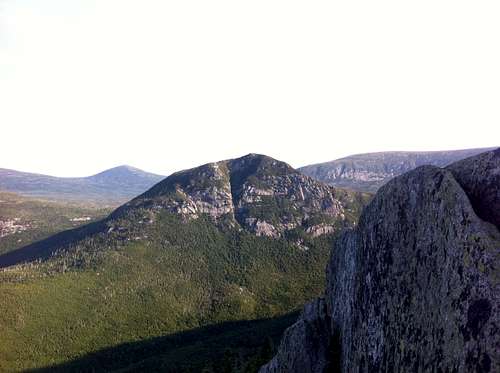
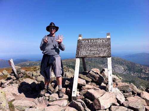
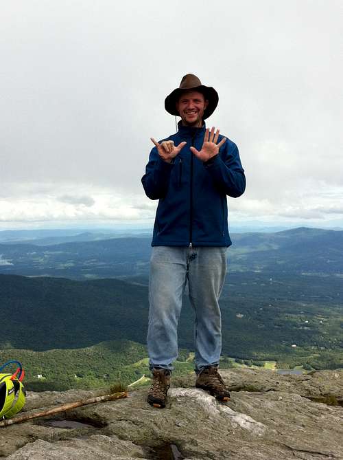
I summited Katahdin at about 9:50 this morning following a demanding hike of just under 4 hours. I was not expecting that trail to be so steep and rocky! The Hunt trail started to grow teeth soon after passing the Katahdin stream waterfall, and steps turned into many rocks with occasional bouldering, which in turn became fun scrambling and bouldering on the ridge with some great views. After climbing that beastly slope, the alpine plateau and gentler slope leading to the summit were a welcome change. Like most people on the trail, I mistook the peak on the East side for the summit (it sure looks higher!) and was taken by surprise to arrive at the actual summit.
After snacking, resting, taking pictures, and watching about a dozen A.T. completers celebrate their achievement, I headed down. As usual, the climb down was more strenuous than the climb up. By the time I got down into the larger trees, my whole body ached from the effort of lowering myself down rocks over and over. I took precious few breaks on the way down, and it still took three hours and left me soaking in my own sweat. The day was picture-perfect, though, and my "pit crew" was waiting for me at trails end.
Tomorrow will be a day in the car to get to New Hampshire, with the Mt. Washington auto road scheduled along the way. Hopefully, the road will allow us to access the summit, and the forecasted rain will keep the crowds down a little bit. Maine is in the books!
As expected, the rain and storms hit New Hampshire hard today, and also as I expected, the Mt. Washington auto road was also closed due to the weather conditions. When we got to Mt. Washington, the summit conditions were 45 degrees with a 75 mph wind and heavy rain. The conditions deteriorated as we drove to Crawford Notch, and by the time we set up the tent, the rain was coming down in sheets and the lightning was nearly constant.
We tried to wait out the storm by doing laundry at the campground, but ended up ditching the tent in the rain and heading to a (nice!) hotel in St. Johnsbury Vermont. I made use of the guest laundry at the hotel to dry the soaking wet tent and rain fly, and we will use them at the base of Mt. Mansfield tomorrow night. Hopefully, the weather will improve. Some day, when I come back to accursed New Hampshire for Mt. Washington, I will be able to summit.
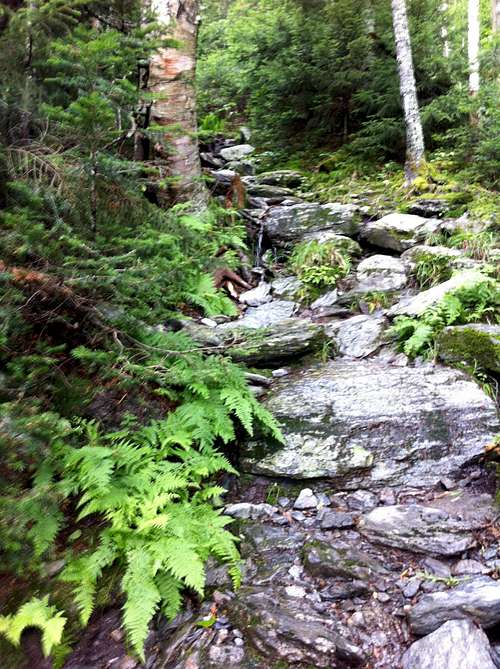
The weather was cool today with some scattered showers, and the drive over to Underhill SP was quick and easy. We had camp set up by noon, and I had a nice meal of mac & cheese before starting the hike up the Laura Cowles trail. I started at about 1:10 pm, and soon discovered that the trail was mostly water (as in a stream!) running down the mountainside. It was very beautiful, though, with the water running over the mica and quartz rocks and under the fern fronds. I think that perhaps the Smurfs live near there! After about 90 minutes, I reached the end of the stunted trees, and the views across Lake Champlain to the Adirondaks were spectacular. The summit was reached at about 3:00, and I spent some time taking pictures and trying to ignore the brats that came up the toll road with their parents.
I descended by the Sunset Ridge trail, which had fantastic views for a long time, and far less water on the trail than the ascent. I arrived back at camp at a little afer 5:00, making the 6-mile loop in around four hours. Tomorrow we will toodle over to the Adirondaks and I will make my attempt on Mt. Marcy on Saturday.
We came across Lake Champlain after partaking in some tourist-type activities in western Vermont. There was little trouble finding the Adirondak Loj campground, and the trailhead for early tomorrow morning has been scouted out. The cool, drizzly weather is forecast to lessen a bit for tomorrow's hiAke.
The weather didn't break entirely, but it wasn't too bad to have some rainless clouds and a breeze during the hike up Marcy. Starting at 6:10 am, I moved quickly for the first several miles of the trail, past Marcy Dam. The trail was fairly muddy, rocky, and root-covered, but was not too steep until after Indian Falls. Even then, I was able to keep up a good pace and still see many of the interesting forest features.
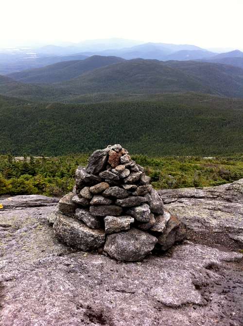
I met the Summit Steward a couple of miles below the summit as she was clearing downed spruce from the trail. A few hard-core trail runners passed me on the way to the summit (and would pass me again on their way down), but I scrambled up the rock faces below the summit and enjoyed the top of New York state at a little after 10:00 am. I didn't linger too long at the top due to the cooler temps and especially the 60+ mph whistling winds! The only place that was at all bearable (even in stocking hat, coat, and gloves) was on the lee side of the summit block. I spent a few minutes reveling in the solitude of being the only person on a state summit--the first time in my travels that has happened--and then I headed down.
On the way down, I went past hundreds of hikers headed for the summit; many with seemingly more muscles than brains. The volume of hikers had churned the muddy trail into a quagmire that was impossible to get through unscathed by mud. I was glad that my wool socks kept my feet nice and toasty, if not bone dry. I stopped at the falls to eat lunch (jerky, fruit snacks, applesauce, etc.) on my way down and arrived back at camp at 2:15--a surprisingly early arrival. With this hike, I am most likely done until next spring, when some high points in the deep south might be added to the list.