
|
|
Mountain/Rock |
|---|---|
|
|
29.81680°N / 84.63040°E |
|
|
Mountaineering |
|
|
23277 ft / 7095 m |
|
|
Overview
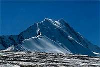 South ridge
Loinbo Kangri is the highest peak in the over 1000km-long range which separates the Yarlung Valley from the Chang Tang.
Sven Hedin, the Swedish explorer baptized the range "Transhimalaya" and the name has lived on until present times. Nowadayas most people call the range Gangdise Shan and in popular terms it's sometimes referred to as "The Kailas Range", due to the fact that Mt Kailas (Kangrinboqe Feng) is the most well-known peak in the range.
In the west Gangdise Shan connects with the Kunlun Shan and in the east it becomes the Nyangchen Tangla Shan.
To be 100% correct, it should be said that Loinbo Kangri is part of the Lunggar Shan mountain range, a sub-range to Gangdise, in which it's the most southernmost peak.
Most peaks in the Gangdise Shan are granite peaks and many of them are sharp edged, steep and "hard-to-climb-looking". Loinbo Kangri is not an exception with its narrow ridges and impressive faces. What may strike you as a bit odd, is that the surrounding hills are round in shape and mostly looks like big piles of sand. In the midst of this rolling landscape you find the Loinbo Kangri Massif in splendid isolation.
Loinbo Kangri was climbed in 1996 when Koreans Cha Jin Chol, You Seok Jae and Bang Jung Il made it to the summit. They were members of the expedition which also made a first ascent of Qungmoganze two weeks earlier.
Getting There
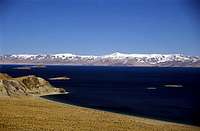
 Super saline lake
If you're acclimatized, you can reach the peak in three days from Lhasa, the provincial capital of Tibet. It's a pretty straight forward journey on good asphalt roads to Shigatze, Tibet's second largest city and an ok ride on partly unsealed roads to Lhatze.
After this junction town (left to Kathmandu and right to western Tibet) the road conditions drops in quality and the topography gets tougher. Seven passes later you are in Saga, the last city of any size. Continue to a small village called Pasakuke and take a right into the real wilderness. A valley with a small river takes you through rolling hills and beautiful rock formations and approximately two hours later you'll have the first stunning views of Loinbo Kangri.
A company which has arranged expeditions to the area before is Shigatse travels, which is to be found in The Yak Hotel in central Lhasa.
Mountain Conditions
 North face
Loinbo Kangri is the only high mountain in the area and therefore the clouds are attracted to the peak. Even if there is blue sky anywhere you look, the peak may be in clouds.
It's a windy place and it's one of those places where you can feel hard winds coming from two directions at the same time. You can get a good feel of this phenomena, visiting the high pass (5500m) which separates the Taro Tso Valley and the valley leading down to Pasakuke. The pass is on the main "road" (read: jeep track) which you travel on to the foot of the mountain.
As most of the peaks has steep faces and quite a lot of cornices, the avalanche risk is to be reckoned with.
The area is famous for having one of the highest snowline in the world - 5800m is not uncommon.
Camping
 Lunggar Tso
The mountain is far away from any type of civilisation and you can pitch your tent anywhere. There are plenty of small streams, fed by the glaciers and natural springs, so it's easy to find one of those camp spots which looks like they are custom made for the purpose.
Ravens destroy or steal basically anything that's left outside the tent, one even tried to nick my Therm'a'rest bag.
When To Climb
 Central ridge
The "normal" Himalayan rules apply: Best seasons are pre-, and post-monsoon. The area is not that much affected by the monsoon as the peaks in the central Himalayan range and therefore you can attempt the peaks at basically any time.
In the fall season the weather is usually quite stable, but colder than in the spring season. During the monsoon, especially the late part in August and early september mud and flooding of the roads can be a problem.
Wildlife
The mountain is within a nature preserve with a lot of wildlife. Big herds of wild donkeys (Kiyang) and Tibetan Gazelles roam the area. You'll see wolves on a daily basis and Taro Tso, a huge lake two hours away is a paradise for ornitologists. Tibetan snow cock, black necked crane and lots of bird of prey are common.Red Tape & logistics
 The north side from far
A permit is required. The fee for Loinbo Kangri main peak is 1080$ (12 persons). The peaks over 6000m in the area go for $2000 if unclimbed and $700 if climbed before. Below 6000m it's usually free of charge or less than $100.
You need an "alien's travel permit" for the area, even if you don't plan to climb Loinbo Kangri. The easiest way to get it is to apply for it in the PSB (Public Security Bureau) office in Lhasa. It costs $10.
There are no public transport further than Pasakuke and either you have to hitch a ride or if you plan to climb or stay for a longer time, you have to rent a vehicle to bring in provisions. A guide and a driver is always attached to the vehicle and costs varies a lot depending on which company you ask. In this case the CTMA (Chinese Tibetan Mountaineering Asociation) gives you outrageous prices and any trekking/touring company will give you a better deal.
See above for a recommended one.
All provisions can be bought in Lhasa, even if "high-tech" mountaineering food only can be found in a few outdoor shops and it's a matter of luck if you find any there at all. Most of what may be available are left-overs from Himalayan expeditions and is sometimes long past expiry date.
If you forgot to buy anything in Lhasa, last chance is Saga and only basic food (noodles etc.) and snacks are to be found there.
Peaks climbed in the range
| Peak | Route | Year |
| P6340 | E Ridge | 1994 |
| Loinbo Kangri | NE Ridge | 1996 |
| P6263 | E Face | 1999 |
| P6202 | NE Ridge | 1999 |
| P6000 | Unknown | 1999 |
| Gopalho S (6100m) | Unknown | 1999 |
| Chomogan/Kangbulu (P6655) | SE Face/E Ridge | 2006 |
| P xxxx | E Ridge | 2006 |
| P yyyy | NW Ridge | 2006 |
| P yyyy | E Ridge | 2006 |
| P zzzz | W Ridge | 2006 |
| Phola Kyang | SE Face/E Ridge | 2006 |
| P 6355 | N Face/NE Ridge | 2006 |
| P 6355 | S/SE Face | 2006 |
| P zzzz | S Face | 2006 |
| P wwww | S Face | 2006 |
| Gopalho (P 6450) | E Face | 2006 |
| Pxxxx | 29 deg 48.327'N 084 deg 38.456'E | 6200m |
| Pyyyy | 29 deg 48.186'N 084 deg 38.872'E | 6289m |
| Pzzzz (Summit 1) | 29 deg 48.221'N 084 deg 39.102'E | 6237m |
| Pzzzz (Summit 2) | 29 deg 48.128'N 084 deg 39.252'E | 6240m |
| Pwwww | 29 deg 55.216'N 084 deg 50.946'E | 6044m |
Heights are predominantly from the Chinese map. The peak named Chomogan
on the Russian map is called Kangbulu, but its quoted height is from
the Russian map. Pxxxx, Pyyyy, Pzzzz, P6355 and P6202 are from west to
east the 5 tops on the ridge south of the Qulunggam Glacier. Pwwww is
located to the northeast of the Loinbo Kangri group.
Reference maps
The left map is Russian. 1:200 000. The right is Chinese 1:100 000  |  |
General Maps
 The range
It's hard to find correct maps for the area. I had to navigate with the help of TPC (Tactical Pilotage Chart) 1:500 000.
Gizi's Tibetan map is not bad, even if there are a lot of shortcomings when it comes to the more remote areas. It's the best I've found for an overview of the area.