
|
|
Custom Object |
|---|---|
|
|
42.11834°N / 90.77818°W |
|
|
Cave |
|
|
Jackson |
A Look Around...

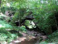 Natural Bridge
Maquoketa Caves was one of those rare places where I started out with rather low expectations and by the end found myself strolling along in stunned silence recounting all the amazing sights I had just encountered. Located southwest of Dubuque, Iowa outside the town of Maquoketa, Maquoketa Caves State Park is quite well known locally, but is otherwise unheard of. I DON"T KNOW WHY THIS IS!!! The tiny Raccoon Creek has dug a deep, and I mean deep, gash in the limestone of northeastern Iowa. In places, sheer rock walls rise nearly 200' out of the creek bed. Interspersed along the walls of the gorge are some 14 named caves which are open for public exploration. Not expecting to find any 'real' caves, I didn't bring any spelunking equipment (meaning I had no flashlight and generally don’t ‘spelunk’ anyway). This limited me to fooling around in a couple of the more shallow caverns as I wandered the four-ish miles of trail within the gorge. For the prepared explorer there are much more interesting places to get oneself into, however...
Directions...
Maquoketa Caves State Park is about an hour north of the Quad Cities. The park is quite simple to find. Just take US-61 north from I-80 to the town of Maquoketa and turn left (west) onto Caves Road and drive the 7-ish miles to the park entrance. There is an interpretive center at the entrance. A mile or so in is the large and obvious parking area at the trailhead.A Brief History...
 Coneflower
The caves themselves are located in the Driftless Region of northeastern Iowa. This means that while many locales to the east and west were scraped clean of major landforms during the last Ice Age the Driftless Region was allowed to evolve and erode naturally for a hundred or so millennia. Over hundreds of thousands of year groundwater has worked to dissolve much of the underlying limestone, creating the numerous small caverns and sinkholes found in the area. At the same time, the diminutive Raccoon Creek has added its slow work to carve an impressive little canyon which has exposed these caverns to the outside world.
The caves were first discovered by white men in the 1830’s but the caves have been of interest to humans for quite some time. Native American artifacts such as stone tools and weapons, found in and around the caves, date back many thousands of years. The area gained park status in 1921 and many of the early facilities at the park were constructed by the Civilian Conservation Corps. Today, as the 323-acre Maquoketa State Park, the facilities include a small campground, picnic shelters, and a stone lodge.
The Caves & Natural Features...
The Caves...
 Rainy Day
Barbell – Two visible openings but left one is impassible. Boost yourself into hole on right and shimmy to back of cave where it opens up big enough for two people.
Bat Passage – Access hole is near Upper Entrance of Dancehall Cave several feet off the ground. Narrow passage ends up 10’ above Dancehall Cave floor.
Dancehall – The big one. 1100’ long and is only developed cave in park. Raccoon Creek flows directly through it.
Dug Out – Little more than a shelter dug out of the natural bridge., accessed by climbing up the rocks.
Hernando’s Hideaway – A fairly good climb from the path to the entrance. Belly crawling and slithering needed to get to the back.
Icy – Two Rooms 20’ above a stream, with cold air that filters in from above.
 Window
Match – Two passages w/in the cave; the largest is 30’ long. Belly crawling is necessary.
Rainy Day – Two rooms; one large, the other smaller and is home to source of Raccoon Creek.
Shinbone – Access is to the right of the larger hole. Crawl 75’ back to interconnected space between the boulders.
Steel Gate Passage – Most difficult cave to explore. Accessed from Upper Dancehall Cave. Over 800’ of tunnels to explore. Quite rugged.
Twin Arch – A rock shelter w/in the limestone bluff.
Up-N-Down – An opening several feet off the ground which you have to go up into after which you descend into the 27’ cave.
Wide Mouth – A large gash in the bluff which leads back 100’ to 3 rooms.
Window – A small crevice in the limestone bluff.
Wye – Begins in the debris of a large sinkhole. Drop 6’ into a small hole on right side of cavern face. Route plummets in depth and divides with the left one becoming the main one. There are more passages farther along but it is very narrow. Some 500’ long.
 Match
MatchA walk through Dancehall Cave...
Other Natural Features...
Balanced Rock – 17 ton boulder located along stairway adjacent to Natural Bridge.
Natural Bridge – A giant (for Iowa) 60’ arch that spans at least 100’ across Raccoon Creek.
Additional Info...

Maquoketa State Park - Official Iowa DNR page.
Hiking Iowa Excerpt - Amazon.com offers a free 'Look Inside' the Hiking Iowa guidebook and guess what? Maquoketa Caves is one of the free pages!
dwHike's Adventures - Shameless self-promotion. You can check out the rest of the pics from my hike here.
