
|
|
Mountain/Rock |
|---|---|
|
|
35.79730°N / 82.9571°W |
|
|
4629 ft / 1411 m |
|
|
Overview
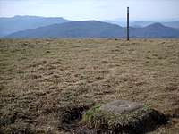
Max Patch Summit
Max Patch is a local favorite in the south-west mountains of North Carolina. It is not nearly the highest peak in the area. In a region home to almost 40 peaks over 6000 feet, Max Patch stands a humble 4629'. Regardless, it is one of the most-visited peaks in the area. What makes Max Patch so unique and popular is its 300+ acres of grassy bald that is easily accessible to most anyone.
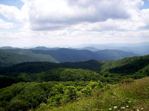
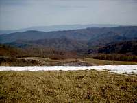
Max Patch sits in northern Haywood County, North Carolina less than a mile from the Tennessee state line. It's location gives Max Patch sweeping vistas in all directions. The Great Smoky Mountains, only 20 miles away, dominate the southwest horizon. To the west the terrain drops over 3600 feet into the flatlands of eastern Tennessee. To the east, 50 miles distant, rises the dark ridgeline of the Black Mountains. Endless ridges and peaks fill in the panorama everywhere else.
History
Summit Lawn
The open grassy fields of Max Patch are not a natural occurance as you can plainly see upon arriving at the peak. In the summer time you can see the Forest Service tractor that is used to maintain the summit lawn.
Forested Max Patch was first cleared in the 1800's and used as pasture for sheep and cattle. Later on, in the 1920's, the peak even served as a landing strip for pilots who gave air tours of the peak and surrounding area. Now, the National Forest Service maintains the peak. Without this maintainence the summit would soon be overgrown with shrubs and then once again, trees.
Getting There
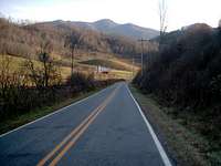
NC-209
Numerous trail roads criss-cross the Max Patch area and the mountain is accessible from almost any direction. Unless you are a local or own a very good map your best bet is to access the peak from Interstate 40 however.
From the east or west take Exit 7 (Harmon's Den). Head north and the road almost immediately becomes gravel. You are on FR-148. This usually well-graded road climbs steadily but never steeply 6.2 miles to SR-1182 (Max Patch Rd). Turn left on SR-1182 and drive 1.5 miles to the Max Patch parking area on the right. You can't miss it.
Trails

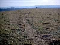
Loop Trail
The Appalachian Trail crosses Max Patch from south to north or vise-versa. The nearest major access points for the Appalachian Trail are:
From the South: Big Pigeon River Bridge, I-40 Exit 451 (TN); 14.4 miles
From the North: Hot Springs, NC; 19.4 miles

The AT
The vast majority of the people who visit Max Patch hike the 2.6 mile loop trail that begins and ends at the Max Patch parking area. From the parking area you will climb over a small fence ladder and then have a choice of going left or right (the trail straight ahead is closed for rehabilitation). Heading left the trail follows an old logging road along the wooded west slope of Max Patch. As the trail makes its way around to the north side of the peak it breaks out into the open and soon jions the Appalachian Trail. From here follow the wood posts marked with white paint up the summit lawn. From the summit the trail heads off the east side of the summit and back into some high shrubs. The trail makes its way back around to the south side of the peak and the parking area.
Red Tape
Summer on Max Patch
Max Patch is part of the French Broad District of the Pisgah National Forest. It is free to access and visit. Fires and camping are prohibited however.
When To Climb
Max Patch can be and is climbed in all seasons. As with the other peaks in this area winter tends to be less busy but I doubt you will ever have the summit to yourself on a sunny day. Summer an fall are the busiest months when people from nearby communities come to escape the valley heat and catch a cool mountain breeze. The roads in the area are frequently snowcovered in the winter, especially in dark, north-facing valleys.
Camping
Camping is prohibited on Max Patch. There are numerous undeveloped campsites along the forest roads leading to the peak. Also, for backpackers, camping is allowed along the Appalachian Trail just not on the summit itself.
Mountain Conditions
The weather on Max Patch tends to not be as severe as higher nearby peaks. A good indicator of the temp on the summit is to look up the weather for Waynesville, North Carolina and subtract 5-10 degrees. In the winter months north-west winds bring prolonged periods of clouds and snow.
Check out the Purchase Knob webcam in the links section for the best view of current conditions. Purchase Knob is only about 15 miles southwest of Max Patch and about the same elevation.
Black Mountain View
Otherwise, contact the French Broad Ranger District office here:
APPALACIAN/FRENCH BROAD RANGER DISTRICT:
DISTRICT RANGER-USDA FOREST SERVICE
PO BOX 128
HOT SPRINGS, NC 28743
PHONE: 828-622-3202
External Links
- Purchase Knob Webcam
Located 15 miles from Max Patch at a similar elevation, this is a great place to see what current conditions are on the mountain. - North Carolina Hiking Page
Hands down the best comprehensive hiking page for the mountains of North Carolina. - National Geographic Trails Illusrated Maps
From this page you can browse National Geographics ever-growing series of excellent topo/trail maps. The French Broad and Nolichucky Rivers map (#782) is very helpful for finding your way around the Max Patch area. - National Forests in North Carolina
The official go-to page for info on Pisgah and other North Carolina National Forests.
DWhike's Adventures - Shameless self promotion...come visit my website for more pics of Max Patch and other places that I have wandered off to in recent years...
wolderiii - Apr 9, 2013 2:29 pm - Hasn't voted
exit numberharmon den exit off of I-40 in NC is exit 7, not exit 40
dwhike - Apr 9, 2013 3:03 pm - Hasn't voted
Re: exit numberThe whole page is due for a revamp...must have been a typo on my part, thx!