
-
 20454 Hits
-
 79.78% Score
-
 11 Votes
|
|
Area/Range |
|---|---|
|
|
44.59880°N / 108.8409°W |
|
|
Hiking, Scrambling |
|
|
Spring, Summer, Fall, Winter |
|
|
6547 ft / 1996 m |
|
|
Overview
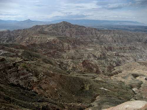
The McCullough Peak Badlands are a desolate but starkly beautiful area of wilderness in the Big Horn Basin near Cody, WY. Wild and unearthly landscapes are common in this place, which is home to a wide variety of wildlife, including deer, antelope, mountain lions, fox, rattlesnakes, a herd of wild horses, bald and golden eagles, sage grouse, merlins, and prairie falcons. The badlands are easily recognized by the distinctive red soil that makes up the area.

Common recreational activities in the McCullough Peaks include hiking, horseback riding, rockhounding, hunting, and ATV/dirtbike travel. The area is rich in fossils, thus making it an important site for paleontological study, and there are countless prehistoric and historic sites throughout the badlands, many of which are still undiscovered and uncatalogued.
The McCullough Peaks area is best known for its herd of wild horses, the members of which are believed to be descended from horses released from Buffalo Bill's Wild West Show over a century ago. Tours to go see and photograph the herd are very popular; a link for information on the tour can be found in the external links section of this page.

There are large reserves of natural gas beneath this area, and there is currently a lot of ongoing debate about whether or not to drill, how much to drill, and about how the drilling process might affect the environment; it remains to be seen how it will all work out.
Getting There
There are numerous ways to enter this area, which encompasses well over 100,000 acres east of Cody, WY, and south of Powell, WY. A good road to enter from the north is found by turning east onto Rd. 18 off of Highway 14 between Cody and Powell. The turn is approximately 3.5 miles southwest of the town of Ralston; after traveling less than a mile on Rd. 18, turn left on Lane 15 and follow it across the top of Corbett Dam and begin looking on the right for a red marker with the number 1647 on it. Turn right here and keep to the right, as there is a private drive with a residence to the left. Keep left at the next fork and look for the brown BLM information station. This entrance will give access to most of the roads on the north side, including the Deer Creek Trail. The are many forks in the road, and, given that there are over 300 miles of roads in this wilderness area, a good map of the area is essential! Road on northern side
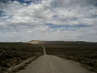 Road on southern side
The best access from the south is from McCullough Peaks Road. Head east from Cody towards Greybull on Highway 14/16/20 and begin marking miles where Highway 120 turns off towards Meeteetse; stay on 14/16/20 for 4.7 miles before turning left off of the highway onto McCullough Peaks Road. This road allows access to the communication towers on top of McCullough Peak in addition to connecting to all of the other roads on the south side, which are generally better than the ones on the north side.
Mountain List
Climbing in this area is mostly limited to hiking and scrambling, with a total of seven peaks with over 300 feet of prominence. The three main summits in the area include the McCullough Peaks Highpoint at 6547 feet and the McCullough Benchmark at 6513 feet, both of which can be reached almost completely by the road; the most interesting summit (Peak 6442) is on the west side overlooking Cody, and is reached via a longer hike and scramble over interesting terrain.Thanks to ListsofJohn.com for the prominence numbers.
| Mountain | Height in ft/m | Coordinates | Prominence (in feet) |
|---|---|---|---|
 McCullough Peak McCullough Peak |
6,547/1996 | 44.587203, -108.8531 | 1,277 |
 McCullough Benchmark McCullough Benchmark |
6513/1985 | 44.5747, -108.8267 | 403 |
 Peak 6442 Peak 6442 |
6442/1964 | 44.60630, -108.8952 | 632 |
 McCullough Peaks East McCullough Peaks East |
5941/1811 | 44.57551, -108.7761 | 431 |
 Peak 5616 Peak 5616 |
5616/1711 | 44.5613, -108.9116 | 306 |
 Peak 5138 Peak 5138 |
5138/1566 | 44.6570, -108.8144 | 308 |
 Peak 4890 Peak 4890 |
4890/1490 | 44.6423, -108.7198 | 300 |
Red Tape
There are no access fees to enter the McCullough Wilderness. The sign system marking access to roads was overhauled in 2004, and as a result, the roads are very clearly marked; there are more than 230 miles of roads marked with white arrows that are open to motorized travel, 20+ miles of roads open to ATV and non-motorized travel, 30 miles of administrative roads, and 60 miles of existing roads that are now permanently closed. Roads that enter this area from the south via Highway 14/16/20 are generally easy and don't require 4WD until you are several miles in, while the roads entering from the north from the Willwood District south of Powell need high clearance 4WD and very good judgment on the part of the driver to avoid getting into places where it is impossible to continue or turn around. The entire badlands area is prone to flash flooding which can quickly make travel impossible in places, so keep an eye on the canyon west of Cody to gauge the approach of any storms.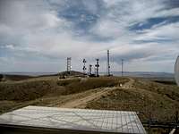
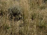 Rattlesnake in the sagebrush
All it takes is one look at this harsh rocky environment covered in sagebrush to know that this is prime rattlesnake country! They like to sunbathe on the rocks and curl up in the brush, so it is not uncommon to have close encounters with snakes that are on or next to the trail. Be extremely careful when hiking anywhere that is off of the road or trail because of the abundance of sagebrush; a slower pace will allow you to listen for the rattle, and will also give the snake a chance to leave as it senses your approach. Make sure you know how to look for them and how to act around these animals, in addition to knowing what to do if you are bitten by one (see link below).
Be sure to bring in enough water to drink, as suitable drinking water is not found in the badlands.

External Links
Information on the McCullough wild horse herd:http://www.blm.gov/wy/st/en/field_offices/Cody/wh.html
http://www.friendsofalegacy.org/mustangs.htm
Horse Tour Information:
http://www.wildmustangtours.com/index.cfm
What to do in case of a Rattlesnake bite:
http://www.whmentors.org/saf/snakes.html
Camping
Camping is allowed in the McCullough Wilderness, with a maximum stay of 14 days in any 28-day period. For more information, visit the BLM camping rules page at:http://www.blm.gov/pgdata/etc/medialib/blm/wy/information/docs.Par.1775.File.dat/wynf-0019.pdf