No comments posted yet.
-
 1178 Hits
-
 0% Score
-
 0 Votes
|
|
Trip Report |
|---|---|
|
|
May 31, 2006 |
|
|
Mountaineering, Trad Climbing, Scrambling |
|
|
Summer |
June 3, 2006
After an uneventful flight in on the 3rd, Cooper and I met up with Heath (a Memphis transplant to Denver) at his place in Denver, which would serve as the basecamp for the next four days of climbing. We took a drive around to catch up and grab a bite to eat in Morrison on the roof of a great little Mexican restaurant. Man, the Coloradoans really know Mexican food! After dinner, we took a quick ride through some of the I-70 corridor mountain roads connecting various little towns and old mining communities. But, not too late, we had to hit the sack. We were gonna get at it early the next day.
June 4, 2006
Cooper was anxious to get at least one 14er in the bag, and we were both anxious to climb some snow. After the recent warm spell, I thought a North Face couloir would provide the greatest protections from rapid daily warming of the snow (a hazard of wet snow avalanche). This led us to the Lost Rat couloir on Grays Peak.
We left Heath’s place at 2:30 AM, long before Heath got up for his work trip to Canada. We hauled ass West on I-70 to our exit. The on-ramp literally gets you off then goyses back over the interstate, then turns to gravel for the approach road. A few more miles up the bumpy grave road and we were at the trailhead at about 4AM.
After packing the packs, we were off on the well defined Grays trail, until we had to break off left to get into the main cirque for the snow climbing routes on Grays and Mount Edwards known as the Remarkables. Remarkable they are.
![Grays & Lost Rat]() Approach to Lost Rat
Approach to Lost Rat
The hike though the basin proved to be more time consuming than I had hoped due primarily to a little postholing in some portions of the snow on the trail. We got within a few hundred feet of the couloir at about sunrise, the cool air of the higher altitude made the snow a more firm, and it was smooth sailing from there on.
I put the trekking poles away and got out the axe for the first third of the couloir, and shortly after that stopped to lather on the sunscreen and strap on the crampons. Only another 600 more feet to go! I kicked the steps for the first 3/4th’s of the route, but then let Cooper polish it off, that really speed us up. I was surprised at how fast I could follow the kicked steps, Coop was a little surprised about how much more strenuous it was to be doing the kicking. Not long after Coop took over, we within 60’ of the East Ridge of Grays, the top of the route.
![Upper Lost Rat]() Upper Lost Rat
Upper Lost Rat
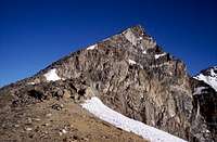
At this point we were faced with a lot of loose scree up the direct line to the ridge, but we chose to go left to gain a steeper face covered with alpine ice from being more shaded than the areas that had melted out. A SWEET pitch of the firm snow took us up to, and through the small cornice to the ridge. The 800+ foot Lost Rat was done!
![Upper Lost Rat]() Uppermost Exit
Uppermost Exit
Now we were well over 13,000’, so the quick rest we took on top of the ridge was much appreciated. We traversed the ridge up and West to the Summit of Grays, spotting many hikers and mountain goats on the way up the standard hiking route. I was seeing plenty of stars by this point as well, but they weren’t in the sky. Imagine squatting down, drinking a beer on an empty stomach, and then standing up…
![Summit Traverse]() Summit Traverse
Summit Traverse
Once we made the summit, we considered traversing over to the summit of another 14er, Torrey’s Peak. We scrambled down to the saddle between the two behemoths, and then decided that the second peak was gonna be more effort for a hiking route than we wanted to spend.
That turned out to be a good call. After we traversed a small snow field from the saddle back over to the Grays hiking route and made it back to the trailhead, we were TOTALLY whipped, out of water and had blistered feet. A good 8 hour day!
June 4, 2006
We had big plans for later in the week, specifically Skywalker couloir on South Arapaho, so we wanted to take it easy today. We set our sights on Baker’s Way (II 5.4) on the First Flatiron. Being on the GIANT east face of the First, we still wanted to get at it before it got too hot at the “low” elevation of about 9000’.
![Approaching the First Flatiron]() Approaching the First
Approaching the First
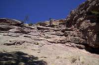
A quick hike from Chautauqua Park in Boulder put us at the base of the route…we thought. Up a rope stretching pitch from the base, I had to stop, belay myself of some sketch gear and let Cooper step up a few feet on the slab so that I’d have enough rope to make it to the belay. Good pitch, but seemed a little stiff for 5.4, but that was supposed to be the crux, only 600’ of easy climbing from there up. Coop followed uneventfully, and enjoyed the view down onto Boulder from the belay. The sun was up and cooking!
![First Pitch]() First Pitch
First Pitch
The terrain did not look like the descriptions of the route I’d read, so I took out the guidebook at the belay. That didn’t help as I wandered around on the terrain above the belay for a half hour or so of climbing up, then down, left and right. There was not much deliberation when I returned to the belay about rapping the 230’ to the base of the climb. This would be interesting with our 185’ rope. But I went off first and found another tree about halfway up the face below us. So two raps and we were back where we started, which I later discovered was at the base of another route called Kamikaze Roofs (II 5.7R).
![Which way???]() I'm Lost
I'm Lost
I wanted to get Coop to the top, but was a little sketched out, so we hiked up to the shortest route on the First, a 2-3 pitch 5.0 on called the Southwest Face. The route finding looked unclear, but after some discussion, off I went. The route came together well, with the first pitch traversing to a bowl just underneath the summit with a large eyebolt. While Cooper was following, a solo climber was downclimbing the route, he assured me it was solid climbing with good holds for the second pitch. He was right and within a half hour or so, Cooper and I were both on top, enjoying the spectacular views of Boulder, Denver, Longs Peak and the rest of the front range. Two raps and we were down the much shorter West face of the First, faced with another dragging hike back to the car. Damn it was hot. This was supposed to be our “easy” day. Although it was short, we were both whipped. That made two summits in two days.
We spent the rest of the day exploring the mountains near Nederland and Eudora making sure that we could find the trailhead efficiently the next day. While it was 95 degrees on the Flatirons, I estimate it was about 50 at the Fouth of July trailhead in the Indian Peaks wilderness that afternoon. We also stopped in Boulder canyon to check out Boulder Falls.
June 5, 2006
After a restless night deliberating on Skywalker (a very steep snow climbs) I had decided that we should carry the rope and pickets. The thought of carrying that extra weight on the approach into South Arapaho did not sound appealing, so I proposed leaving all that stuff in the car, and wearing the sneakers to climb up the Class 2 Grade II Southeast Ridge. I think Coop was feeling a little whipped too, and he liked the idea of going light, so we did.
![South Arapaho SE Ridge]() SE Ridge
SE Ridge
This part of the Indian Peaks is spectacular, and Skywalker will be on the menu for next year! The views were great, although the fist 3.5 miles of the 4 mile climb were a little boring for a climber. The last half mile provided many views from the high flank of South Arapaho. Although the route is class 2, with some route finding difficulty, our route provided a class 3 scramble to the summit. The views all over the Front Range of the Rockies were amazing. We could see Grays and the summit of the First Flatiron from the two previous days. The summit maker was placed in the 1928 and pointed out the prominent peaks and landmarks in every direction. A little snack, that I thought we were going to have to fight off a marmot for, and we were off back down the ridge, through the meadow and back to treeline and the trailhead. Thee summits in three days, not too bad.
![Summit]() My Partner on the Summit
My Partner on the Summit
I felt a little crappy for wussing out of Skywalker, and we were both agreeable to Wednesday off and just recuperating, so we had a few beers with dinner and planned on sleeping late.
June 6, 2006
Well sleeping in provided to be not as easy as we thought. Our body clocks were used to the early starts, and we were up around 6. As we started stirring I just started packing a light pack with the thoughts of a snow route called Little Italy on Pikes Peak on my mind. Worst case was we’d just play like the rest of the tourists and drive to the top. Coop followed my lead and we were hustling out to the gully that we had only read 3 lines about on the net.
We drove down to Colorado Springs, grabbed a quick bite and were at the USFS “park” entrance at 8AM, 1 hour after it opened.
We zipped up the Pikes Peak road for about a dozen miles to a little camp called Glen Cove and Little Italy was in pain view. We pulled off the road just a couple miles past Glen Cove and traversed over to the route. As beat as we were, I fully expected to climb the bottom portion of the route (the shoe portion of the “boot” of the Italy shaped gully), and turn around do to general fatigue or crappy snow conditions. So we went in hiking pants and short sleeves, but each carried a long sleeve shirt and a light shell jacket.
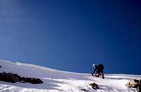
![Little Italy]() Little Italy
Little Italy
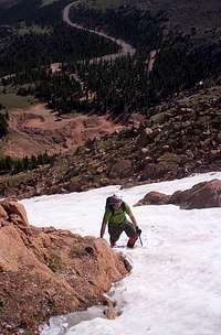
We got into the couloir and the snow was pretty crappy, but we could stay out of avalanche territory by staying right one the edge. Often with one hand and boot on the red granite and the other on snow. We turned the corner of the boot (looking up the “leg”) and the route just kept pulling us further and further up.
![Lower Little Italy]() Climbing Lower Little Italy
Climbing Lower Little Italy
![Looking up Little Italy]() Looking up Little Italy
Looking up Little Italy
![Upper Slope of Little Italy]() Topping Out
Topping Out
After 1100’ of snow climbing and occasionally rock scrambling, we made the ridge where the wind cooled us off significantly and we had to break out the shells. There was an obvious trail below us on the South side of the ridge, but I had no idea where it went. At this point I was kicking myself for not bringing a map, so we hustled along the ridge East toward the road. The whole time I was thinking about the worst case scenarios until we traversed one large bulge on the ridge and the road was just underneath us. As we popped out on the road, a family slowly cruising down the Pikes Peak road almost came to a stop as the looked at us (with our packs, ice axes and helmets) like we were aliens. They passed a friendly hi and a wave so I asked if the mind if we caught a ride. They said sure, and we hopped in the back of their pick-up for the 2.2 miles down the road back to our car. I asked them if I could give them a couple bucks, they refused but wanted to confirm their thoughts that we had climbed that gully, we assured them that we had, they left us with a “WOW”!
We made the slow drive up to the summit. Man, what a zoo. I bought a hamburger for $3 at above 14,000’. That place is nuts. I did jump down a couple rocks to check out one marker, and back came the 14k stars and headache. The summit has a cog railroad that ends at the summit as well. We hung out and took a few pics like real tourists, then headed down.
On the way out, we saw a sign for “Rock Climbing” at Glen Cove and went to check it out, where we spoke with a couple of guides from Pikes Peak Alpine School. I was surprised to see how much clean rock there was on this little sub-peak of Pikes and on the North Face we saw from the summit. These guys were manning a table just in front of some top-ropes they had set up. We talked about some of the routes in the area, and some of the other routes we had in common for a half hour or so, and we were on our way.
One more night at Heath’s place, and we’d be on our way back to Memphis… I can’t wait to go back.
After an uneventful flight in on the 3rd, Cooper and I met up with Heath (a Memphis transplant to Denver) at his place in Denver, which would serve as the basecamp for the next four days of climbing. We took a drive around to catch up and grab a bite to eat in Morrison on the roof of a great little Mexican restaurant. Man, the Coloradoans really know Mexican food! After dinner, we took a quick ride through some of the I-70 corridor mountain roads connecting various little towns and old mining communities. But, not too late, we had to hit the sack. We were gonna get at it early the next day.
June 4, 2006
Cooper was anxious to get at least one 14er in the bag, and we were both anxious to climb some snow. After the recent warm spell, I thought a North Face couloir would provide the greatest protections from rapid daily warming of the snow (a hazard of wet snow avalanche). This led us to the Lost Rat couloir on Grays Peak.
We left Heath’s place at 2:30 AM, long before Heath got up for his work trip to Canada. We hauled ass West on I-70 to our exit. The on-ramp literally gets you off then goyses back over the interstate, then turns to gravel for the approach road. A few more miles up the bumpy grave road and we were at the trailhead at about 4AM.
After packing the packs, we were off on the well defined Grays trail, until we had to break off left to get into the main cirque for the snow climbing routes on Grays and Mount Edwards known as the Remarkables. Remarkable they are.
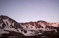 Approach to Lost Rat
The hike though the basin proved to be more time consuming than I had hoped due primarily to a little postholing in some portions of the snow on the trail. We got within a few hundred feet of the couloir at about sunrise, the cool air of the higher altitude made the snow a more firm, and it was smooth sailing from there on.
I put the trekking poles away and got out the axe for the first third of the couloir, and shortly after that stopped to lather on the sunscreen and strap on the crampons. Only another 600 more feet to go! I kicked the steps for the first 3/4th’s of the route, but then let Cooper polish it off, that really speed us up. I was surprised at how fast I could follow the kicked steps, Coop was a little surprised about how much more strenuous it was to be doing the kicking. Not long after Coop took over, we within 60’ of the East Ridge of Grays, the top of the route.
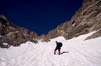 Upper Lost Rat
At this point we were faced with a lot of loose scree up the direct line to the ridge, but we chose to go left to gain a steeper face covered with alpine ice from being more shaded than the areas that had melted out. A SWEET pitch of the firm snow took us up to, and through the small cornice to the ridge. The 800+ foot Lost Rat was done!
 Uppermost Exit
Now we were well over 13,000’, so the quick rest we took on top of the ridge was much appreciated. We traversed the ridge up and West to the Summit of Grays, spotting many hikers and mountain goats on the way up the standard hiking route. I was seeing plenty of stars by this point as well, but they weren’t in the sky. Imagine squatting down, drinking a beer on an empty stomach, and then standing up…
 Summit Traverse
Once we made the summit, we considered traversing over to the summit of another 14er, Torrey’s Peak. We scrambled down to the saddle between the two behemoths, and then decided that the second peak was gonna be more effort for a hiking route than we wanted to spend.
That turned out to be a good call. After we traversed a small snow field from the saddle back over to the Grays hiking route and made it back to the trailhead, we were TOTALLY whipped, out of water and had blistered feet. A good 8 hour day!
June 4, 2006
We had big plans for later in the week, specifically Skywalker couloir on South Arapaho, so we wanted to take it easy today. We set our sights on Baker’s Way (II 5.4) on the First Flatiron. Being on the GIANT east face of the First, we still wanted to get at it before it got too hot at the “low” elevation of about 9000’.
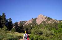 Approaching the First
A quick hike from Chautauqua Park in Boulder put us at the base of the route…we thought. Up a rope stretching pitch from the base, I had to stop, belay myself of some sketch gear and let Cooper step up a few feet on the slab so that I’d have enough rope to make it to the belay. Good pitch, but seemed a little stiff for 5.4, but that was supposed to be the crux, only 600’ of easy climbing from there up. Coop followed uneventfully, and enjoyed the view down onto Boulder from the belay. The sun was up and cooking!
 First Pitch
The terrain did not look like the descriptions of the route I’d read, so I took out the guidebook at the belay. That didn’t help as I wandered around on the terrain above the belay for a half hour or so of climbing up, then down, left and right. There was not much deliberation when I returned to the belay about rapping the 230’ to the base of the climb. This would be interesting with our 185’ rope. But I went off first and found another tree about halfway up the face below us. So two raps and we were back where we started, which I later discovered was at the base of another route called Kamikaze Roofs (II 5.7R).
 I'm Lost
I wanted to get Coop to the top, but was a little sketched out, so we hiked up to the shortest route on the First, a 2-3 pitch 5.0 on called the Southwest Face. The route finding looked unclear, but after some discussion, off I went. The route came together well, with the first pitch traversing to a bowl just underneath the summit with a large eyebolt. While Cooper was following, a solo climber was downclimbing the route, he assured me it was solid climbing with good holds for the second pitch. He was right and within a half hour or so, Cooper and I were both on top, enjoying the spectacular views of Boulder, Denver, Longs Peak and the rest of the front range. Two raps and we were down the much shorter West face of the First, faced with another dragging hike back to the car. Damn it was hot. This was supposed to be our “easy” day. Although it was short, we were both whipped. That made two summits in two days.
We spent the rest of the day exploring the mountains near Nederland and Eudora making sure that we could find the trailhead efficiently the next day. While it was 95 degrees on the Flatirons, I estimate it was about 50 at the Fouth of July trailhead in the Indian Peaks wilderness that afternoon. We also stopped in Boulder canyon to check out Boulder Falls.
June 5, 2006
After a restless night deliberating on Skywalker (a very steep snow climbs) I had decided that we should carry the rope and pickets. The thought of carrying that extra weight on the approach into South Arapaho did not sound appealing, so I proposed leaving all that stuff in the car, and wearing the sneakers to climb up the Class 2 Grade II Southeast Ridge. I think Coop was feeling a little whipped too, and he liked the idea of going light, so we did.
 SE Ridge
This part of the Indian Peaks is spectacular, and Skywalker will be on the menu for next year! The views were great, although the fist 3.5 miles of the 4 mile climb were a little boring for a climber. The last half mile provided many views from the high flank of South Arapaho. Although the route is class 2, with some route finding difficulty, our route provided a class 3 scramble to the summit. The views all over the Front Range of the Rockies were amazing. We could see Grays and the summit of the First Flatiron from the two previous days. The summit maker was placed in the 1928 and pointed out the prominent peaks and landmarks in every direction. A little snack, that I thought we were going to have to fight off a marmot for, and we were off back down the ridge, through the meadow and back to treeline and the trailhead. Thee summits in three days, not too bad.
 My Partner on the Summit
I felt a little crappy for wussing out of Skywalker, and we were both agreeable to Wednesday off and just recuperating, so we had a few beers with dinner and planned on sleeping late.
June 6, 2006
Well sleeping in provided to be not as easy as we thought. Our body clocks were used to the early starts, and we were up around 6. As we started stirring I just started packing a light pack with the thoughts of a snow route called Little Italy on Pikes Peak on my mind. Worst case was we’d just play like the rest of the tourists and drive to the top. Coop followed my lead and we were hustling out to the gully that we had only read 3 lines about on the net.
We drove down to Colorado Springs, grabbed a quick bite and were at the USFS “park” entrance at 8AM, 1 hour after it opened.
We zipped up the Pikes Peak road for about a dozen miles to a little camp called Glen Cove and Little Italy was in pain view. We pulled off the road just a couple miles past Glen Cove and traversed over to the route. As beat as we were, I fully expected to climb the bottom portion of the route (the shoe portion of the “boot” of the Italy shaped gully), and turn around do to general fatigue or crappy snow conditions. So we went in hiking pants and short sleeves, but each carried a long sleeve shirt and a light shell jacket.
 Little Italy
We got into the couloir and the snow was pretty crappy, but we could stay out of avalanche territory by staying right one the edge. Often with one hand and boot on the red granite and the other on snow. We turned the corner of the boot (looking up the “leg”) and the route just kept pulling us further and further up.
 Climbing Lower Little Italy
 Looking up Little Italy
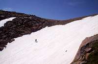 Topping Out
After 1100’ of snow climbing and occasionally rock scrambling, we made the ridge where the wind cooled us off significantly and we had to break out the shells. There was an obvious trail below us on the South side of the ridge, but I had no idea where it went. At this point I was kicking myself for not bringing a map, so we hustled along the ridge East toward the road. The whole time I was thinking about the worst case scenarios until we traversed one large bulge on the ridge and the road was just underneath us. As we popped out on the road, a family slowly cruising down the Pikes Peak road almost came to a stop as the looked at us (with our packs, ice axes and helmets) like we were aliens. They passed a friendly hi and a wave so I asked if the mind if we caught a ride. They said sure, and we hopped in the back of their pick-up for the 2.2 miles down the road back to our car. I asked them if I could give them a couple bucks, they refused but wanted to confirm their thoughts that we had climbed that gully, we assured them that we had, they left us with a “WOW”!
We made the slow drive up to the summit. Man, what a zoo. I bought a hamburger for $3 at above 14,000’. That place is nuts. I did jump down a couple rocks to check out one marker, and back came the 14k stars and headache. The summit has a cog railroad that ends at the summit as well. We hung out and took a few pics like real tourists, then headed down.
On the way out, we saw a sign for “Rock Climbing” at Glen Cove and went to check it out, where we spoke with a couple of guides from Pikes Peak Alpine School. I was surprised to see how much clean rock there was on this little sub-peak of Pikes and on the North Face we saw from the summit. These guys were manning a table just in front of some top-ropes they had set up. We talked about some of the routes in the area, and some of the other routes we had in common for a half hour or so, and we were on our way.
One more night at Heath’s place, and we’d be on our way back to Memphis… I can’t wait to go back.