Misc. State Highpoints
Highpoints trip of October, 2007
10/17/07 – Flew to Dayton, OH and rented a Chevy Cobalt at National
10/18/07 – Started about 0430 driving to Charles Mound, IL. Called land owner who stated access is only permitted first weekends of June - Sept ; Continued driving to Timm’s Hill, WI
![Timm s Hill, WI]() Timm's Hill, WI
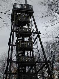
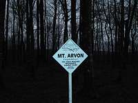
Timm's Hill, WI and hiked short distance to summit; Drove on toward Mt Arvon, MI (1,979’) and slept in car at a rest stop since it was raining.
![Mt Arvon, MI]() Mt Arvon, MI
Mt Arvon, MI
10/19/07 – Drove into L’Anse, MI before dawn and drove through maze that leads to the trailhead (Road has been improved and goes all the way to summit now!) Hiked up road to summit ~ 1 mi RT; Drove back to L’Anse getting lost after a wrong turn in the maze; Continued driving to Grand Marais, MN ; Stopped in visitor center for help finding county road 12 and drove to trailhead ; Although late afternoon, decided to hike to Eagle Mtn, MN (2,301’) that same day; On the trail, I met a scout troop heading back after encountering high waters across trail; Continued and forded several sections 100 – 200’ long that were flooded knee high removing boots and socks four times during the 7 mile roundtrip. Eagle Mtn is located about 17 mi NW of Grand Marais in the Boundary Waters Canoe Area Wilderness of Superior National Forest.
![Eagle Mtn, MN]() Eagle Mtn, MN
Eagle Mtn, MN Self-issue day use permits are available at the trailhead for no fee. One-third of the 3 million acre Superior National Forest is the Boundary Waters Canoe Area Wilderness. Over 445,000 acres of the forest is surface water with more than 1,300 miles of cold-water streams and 950 miles of warm-water streams within the boundaries of the national forest.
10/20/07 – Drove toward Hawkeye Point, IA (1,670’)
![Hawkeye Pt, IA]() Hawkeye Pt, IA
Hawkeye Pt, IA about 5 miles NNE of Sibley, IA, after sleeping in car at rest areas along highway; when I got to Minneapolis, I got lost downtown due to the collapsed I 35 bridge and poor signage! Called highpoint owners for permission to visit, but no longer a working # ; (For sale sign on property, and no sign of anyone around premises as I did the highpoint) ; Drove on toward Taum Sauk Mtn, MO (1,772’) about 6 miles WSW of Ironton, MO, after spending the night in a motel near St Louis
![Taum Sauk Mtn, MO]() Taum Sauk Mtn, MO
Taum Sauk Mtn, MO
10/21/07 – Continued driving in am, arriving at the highpoint around noon ; Looked around for highpoint which was right beside the parking lot by a lookout tower! ; Drove to Magazine Mtn, AR (2,753’) arriving just before dark and had good nights sleep in my tent which I set up in the overflow camping area at Cameron Bluff state park used for picnics during the day
![Magazine Mtn, AR]() Magazine Mtn, AR
Magazine Mtn, AR
10/22/07 – Got up before dawn and heated oatmeal and coffee before hiking to the summit at first light; The trail was really nice and is about 1 mile RT ; Drove to Woodall Mtn, MS (806’) about 3 miles South of Iuka, MS, in a light drizzle. During the Civil War some bloody battles were fought nearby.
![Woodall Mtn, MS]() Woodall Mtn, MS
Woodall Mtn, MS In the battle of Iuka, MS, nearly 1/3 of those engaged fell. There is a former fire lookout tower at the highpoint ; Headed southwest toward the Naches Trace Parkway which was a beautiful stretch of highway without signs, towns, lights, etc…just a raised 2 lane boulevard through the state with a 50 mph speed limit ; Picked up I 40 west at Jackson, MS and drove to a rest area where I tried to get some sleep in the back seat ;
10/23/07 – Tried to find hwy 147 S at Arcadia, LA which is about 10 miles N of the highpoint and asked a city policeman, who didn’t know where it was! He directed me to an all night gas station which did have knowledge of how to get there ; Parked in old church parking lot and slept several hours before dawn when I started hiking 1.8 mi RT to Driskill Mtn, LA (535’) over muddy logging trails ;
![Driskill Mtn, LA]() Driskill Mtn, LA
Driskill Mtn, LA Met a logger in a dualie who was slip-sliding down the ruts and helped me get back on the right track after a wrong turn; Reached the highpoint in a light drizzle ; Returned to the car and bagged my muddy boots for later cleanup in a rest area sink ; Headed east on I 40 toward Lakewood Park, FL (345’) in a steady light rain passing through Gulfport, Biloxi, Mobile, Pensacola and Ft Walton Beach
![Lakewood Park, FL]() Lakewood Park, FL
Lakewood Park, FL before reaching Florala on the border between FL and AL where a local directed me to the highpoint ; Continued driving toward Brasstown Bald, GA (4,784’)which is about 12 miles E of Blairsville, GA, looking for a rest area on the interstate to Atlanta ; Finding none, continued north and finally stopped in a small rural village for a couple hours of sleep before driving to the parking area for the highpoint.
![Brasstown Bald, GA]() Brasstown Bald, GA
Brasstown Bald, GA 10/24/07 - I slept several more hours until dawn when I hiked up the nice trail 1 mile RT; Drove toward Sassafras Mtn, SC (3,560’) about 14 miles N of Pickens, SC; a rural mail carrier delivering near the cutoff to the summit gave me advice on how to find the highpoint which did not have any signage visible
![Sassafras Mtn, SC]() Sassafras Mtn, SC
Sassafras Mtn, SC; Continued driving to Mt Mitchell, NC (6,684’) which is located along the Blue Ridge Parkway about 30 miles NE of Asheville, NC; the parkway is a similar road to the Natchez Trace Parkway in MS ; It was raining along the way, but when the clouds lifted for brief periods the fall foliage was fantastic ; When I reached the trailhead for the highpoint, it was muddy and blocked with yellow tape; After poking around, I found a way to bushwhack around the normal route and eventually reached the summit ; The Observation tower that used to be there has been removed and is being replaced.
![Mt Mitchell, NC]() Mt Mitchell, NC
Mt Mitchell, NC This is the highest point East of the Mississippi river. From there, I continued on the Blue Ridge Parkway for another 40 – 50 miles before heading off in search of Mt Rodgers, VA (5,729’) which is near Mouth of Wilson, VA ; After great difficulty, I finally navigated to the trailhead in steady rain and watched the dusk turn to night ; I once again slept in the car due to heavy rains
![Mt Rogers, VA]() Mt Rogers, VA
Mt Rogers, VA
10/25/07 - I waited until first light to head up the Rhododendron Trail in my goretex jacket to the Appalachian trail which goes very near the highpoint ; It rained most of the way in and out on the 8.5 mile hike which gains about 1,500’ and I had the whole area to myself ; After returning to the car, I stopped at the Grayson Highlands State Park HQ and took a sink bath in warm water and replaced my soaked clothing with clean dry items ; I drove on looking for Black Mtn, KY (4,139’) having more trouble finding road signs until I finally reached Norton, VA and shortly thereafter found Cumberland, VA and a sign for Hwy 160 E which corkscrewed up the mountain to the state line of KY; There I found the lane that leads up to the summit (Hwy 160 is quite a stretch of highway which in some ways reminded me of Going to the Sun Hwy in Glacier Park…It is very narrow, steeply climbing and winds its way to the pass near the summit of Black Mtn for miles through the forest) This highpoint is owned by Penn Virginia Coal Company and they require that you sign a waiver prior to visiting due to concern that one of the numerous tunnels under the mountain may collapse.
![Black Mtn, KY]() Black Mtn, KY
Black Mtn, KY After taking several photos, I continued on into Lynch, KY which is coal mining country big time with huge piles of coal and large trucks hauling it as well as trains and from there headed to I 75 N to return to Fairborn, OH where my journey had started the previous week ; I arrived around 2030 hrs and was greeted with a great meal prepared by my Mom after topping off the car at $2.69/ gal (The next morning the price had been raised to $2.89!)
Trip Summary:
8 days
5,500 miles
21 miles hiked
3,475’ elevation gained
14 state highpoints
I decided to forget about NJ and DE highpoints since IL had been denied and since they do not require any hiking, but rather just driving through the congestion of the east coast metro areas. Thus, my highpointing has reached a satisfactory conclusion with 46 states and only Alaska remaining as a significant challenge should I decide to try it. At this time that seems unlikely due to the significant cost of time, energy and resources that would be required. I have never had a great desire to engage in an expedition style assault on a mountain which goes against my preference for fair weather enjoyment.
This group of 14 high points entailed 5,500 miles of driving which was spread over 8 days during the most beautiful time of the year with regard to temps and colors. I was hit with lots of rain during the trip, but that was a nice change from the desert climate I live in. The combined driving and hiking was at least as difficult as my recent rim to rim to rim hike at the Grand Canyon over the weekend of 10/13 and 14 with the luxury of a night sleeping in a cabin on the North rim between crossings. The Chevy Cobalt performed well giving me about 38 mpg for the trip. All in all, it was another great adventure which I recommend to anyone with an interest in seeing our great country and enjoying some interesting hikes along the way.


Comments
Post a Comment