
|
|
Route |
|---|---|
|
|
46.36088°N / 14.54311°E |
|
|
Hiking, Scrambling |
|
|
Summer, Fall |
|
|
Less than two hours |
|
|
undemanding to very demanding |
|
|
Overview
Mlinarsko Sedlo is the saddle between Grintovec to the W and Dolgi hrbet to the E. This is the pass between the Ravenska Kocna valley to the N, and Veliki Podi, the big grounds on the S side of the range.The blue lines on the map below are the three routes leaving Mlinarsko Sedlo eastward or south-eastward. These three marked and secured routes rejoin the Skuta standard (yellow line on the map).
Getting There
Reach Mlinarsko sedlo from the Ceška koča Hut along this route, or upon descending from Grintovec, or of course by reversing one of the further described routes, upon descending or ascending along the Skuta standard.Route Descriptions
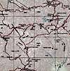
* The route due southmost, signposted Cojzova koča, is an undemanding marked and secured mountain-hiking path, which gently goes down and rejoins the Skuta standard route (the yellow line on the map) in the middle of Veliki Podi (the Big grounds).
* The undemanding and marked route leaving Mlinarsko Sedlo SE-wards, traversing below the Dolgi Hrbet S face is signposted Skuta (the middle blue line on the map). It rejoins the Skuta standard (yellow line on the map) just below the secured scramble up a short wall (see the Skuta standard description).
* A route signposted Dolgi Hrbet steeply leaves Mlinarsko Sedlo eastwards (the top blue line on the map). This very demanding marked and secured mountain-hiking path called Crossing Dolgi hrbet (check the primary image) is the most famous ridge-crossing-of-the-like in the range. If we stick to the aid (pegs and metal wires -possible use of via-ferrata self-protection devices), favour gymnastics, and do not fear exposition, the route is just perfect (wind conditions allowing). The route rejoins the Skuta standard at Škrbina, the notch between Dolgi Hrbet and Štruca.
Essential Gear
A map, a whistle, a head lamp, rain and wind clothing.Possible use of via-ferrata type self protection on the secured sections.