This great imposing vallon is actually a gorge underlying the Mont Père Laurent
(2.625m) and above the Municipality of Grand Brissogne
(906m), located in the Southern Sore of Middle and Central Aosta Valley. From the slopes of
Monte Emilius (3.559m) fact falls to the South along the Vallon of the Arpisson on the Western shore and that of Brissogne / Les Laures on the Eastern side, that long buttress which, after having formed the Testa Blantsette (Whitish Head from the toponym of the adjacent glacier below the East Wall of Monte Emilius), the Col Peccoz or Peckoz, the Becca di Seneva with the keep nicknamed
"Lo Cordagnë or Cordagnì" (The shoemaker, because, when he is enveloped by the clouds, he appears, coming out on top of them, in this folded garment as well as intent on his work), he ends with the grandiose bastion of Mont Père Saint Laurent
(2.625m). A mammoth mountain that overlooks the towns of Grand Brissogne (to the North-east and north) and Pollein (towards North and north-west), taking away most of their light from these two municipalities and dominating them with its large and almost rounded mass. With a good-natured appearance, if observed from the North where it pushes a radial series of gullies to the bottom, it drops vertical walls to the East and Northwest (
"Paé Tzana" in patois language or Yellow Wall; on which in the channel alongside the good as well as strong Pollein Mountain Guide, Ezio Marlier, has opened an waterfall ice route in piolet-traction into the same gully). Its gullies (half a dozen from East to West) look bleak and blackish in summer and loom over the inhabited areas, but, when the snow arrives, they seem to become smiling and inviting, giving the mountain the appearance of a peaceful snowman. Nothing could be more false, because, at least I who have my son and my grandson who live below their in that of Grand Pollein, sometimes look at them with great apprehension, because they go up, up almost to the plateau of the Vetta. If there was a huge snowfall, I wonder, or a flood like in 2000 what could happen.
So I decided to go and have a little look around there ...
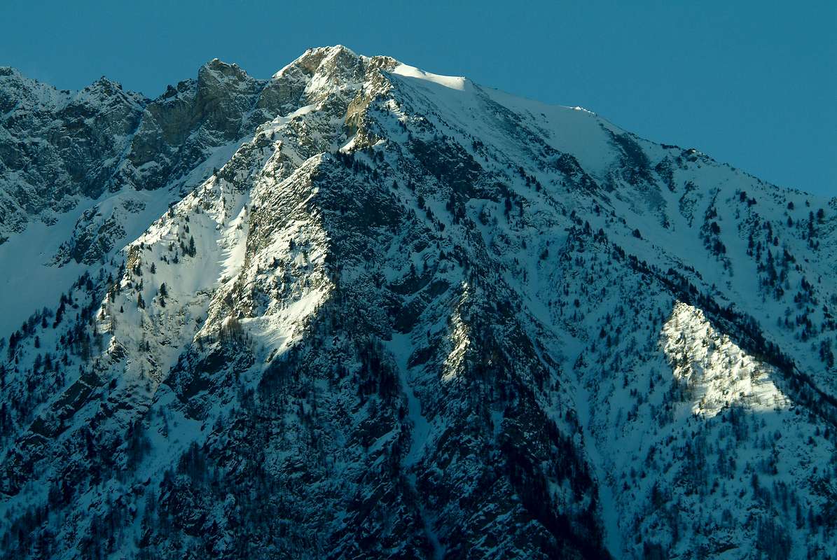
![]() Highest sector of Mont Père Laurent (2.625m), just below the "Emilius's Sources" by Ar pisson Glaciers
by Antonio 2010
Questo vallone in realtà é una gorgia sottostante il Mont Père Laurent (2.625 m), nonché al di sopra dell'abitato del Comune di Grand Brissogne (906 m), situato sulla sponda Meridionale della Media Valle d'Aosta.
Highest sector of Mont Père Laurent (2.625m), just below the "Emilius's Sources" by Ar pisson Glaciers
by Antonio 2010
Questo vallone in realtà é una gorgia sottostante il Mont Père Laurent (2.625 m), nonché al di sopra dell'abitato del Comune di Grand Brissogne (906 m), situato sulla sponda Meridionale della Media Valle d'Aosta. Dalle pendici del
Monte Emilius (3.559 m) scende infatti, verso Sud il lungo Vallone dell'Arpisson sulla sponda Occidentale e quello di Brissogne / Les Laures sul lato Orientale, quel lungo contrafforte che, dopo aver formato la Testa Blantsette (dal toponimo dell'adiacente ghiacciaio sottostante la Parete Est dell'Emilius), il Col Peccoz oppure Peckoz, la Becca di Seneva con il torrione soprannominato
"Lo Cordagnë oppure Cordagnì" (Il calzolaio, perchè, allorché viene avvolto dalle nubi, appare, uscendone in sommo alle medesime, in questa veste piegato nonché intento nel suo lavoro), si esaurisce con il grandioso bastione del Mont Père Saint Laurent
(2.625 m). Una mastodontica montagna che sovrasta gli abitati di Grand Brissogne (a Nordest e Nord) e di Pollein (a Nord e Nordovest) togliendo a questi due comuni gran parte della loro luce e sovrastando i medesimi con la sua grande e quasi tondeggiante massa. Dall'aspetto bonario, se osservato da Settentrione dove spinge sul fondo una serie a raggiera di canaloni, lascia cadere pareti verticali ad Oriente ed a Nordovest (
"Paé Tzana" o Parete Gialla; sulla quale nel canale affianco la brava nonché forte Guida Alpina di Pollein, Ezio Marlier, ha aperto una via glaciale in piolet-traction nella cascata di ghiaccio formantesi nel canalone medesimo). I suoi canaloni (una mezza dozzina da Est ad Ovest) hanno un aspetto tetro in estate ed incombono sugli abitati, ma, quando arriva la neve, paiono diventare sorridenti ed invitanti, dando alla montagna l'aspetto di un tranquillo pupazzo di neve. Nulla di più falso, perché, almeno io che ho mio figlio e mio nipotino che vi abiatano al di sotto in quel di Grand Pollei, a volte li guardo con grande apprensione, perché vanno in sù, sù fino quasi al plateau della Vetta. Se venisse una enorme nevicata, mi chiedo, oppure un alluvione come nel 2000 chissà che cosa potrebbe succedere.
Così mi sono deciso ad andare a dare un'occhiatina per di là ...
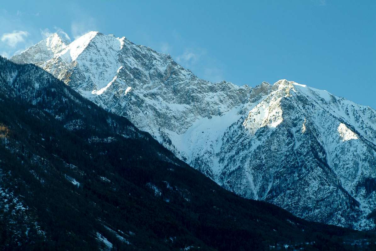
![]() The long ridge from Monte Emilius towards Becca di Seneva, Cordagnë or Cordagnì and Mont Père Laurent
by Emilio Bertona aka emilius Januarius 2004
The long ridge from Monte Emilius towards Becca di Seneva, Cordagnë or Cordagnì and Mont Père Laurent
by Emilio Bertona aka emilius Januarius 2004
Getting There
By car:
- From TORINO, MILANO, etc: Motorway A5. Exit at IVREA or Quincinetto (PIEDMONT)
From IVREA Town: in West (Northern side) towards Pont Saint Martin, Donnas, Bard, Arnad, Champdepraz, Saint Vincent, Châtillon, Nus and Quart; also in Southern side in respect to the Dora Baltea Stream: Pontey, Fénis, Saint Marcel, Grand Brissogne Municipalities.
From Courmayeur Resort: in East and in Norhern side respect to Baltea towards: Pré St. Didier, Morgex, La Salle, Arvier, Villeneuve, Saint Pierre, Sarre, Aosta Municipalities.
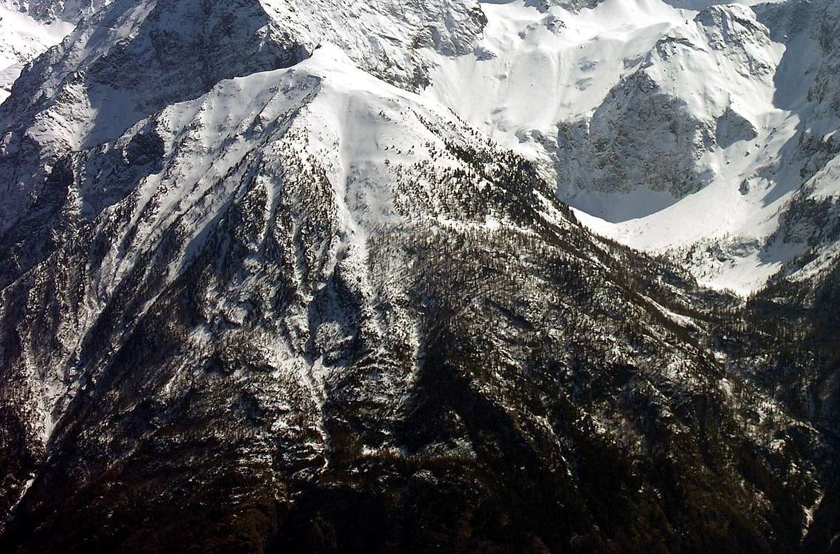
![]() Les Laures Lower part above Grand Brissogne
From Aosta Town or by Châtillon/Nus towards Grand Brissogne Commons
From Grand Brissogne (827m) to L'Arp, dirt road, Les Laures small Valley-Ernesto Ménabreaz Shelter at Lower Laures Lake (2546m), path-muletrack.
Les Laures Lower part above Grand Brissogne
From Aosta Town or by Châtillon/Nus towards Grand Brissogne Commons
From Grand Brissogne (827m) to L'Arp, dirt road, Les Laures small Valley-Ernesto Ménabreaz Shelter at Lower Laures Lake (2546m), path-muletrack.
- From FRANCE: through the Mont Blanc Tunnel to Entrèves-crossroads to Vény/Ferret Valleys - Mountain Guides of Courmayeur - La Saxe Rock Gym - Courmayeur. By Little Saint Bernard Pass, closed since November until half May to La Thuile Valley - Pré Saint Didier - Courmayeur.
- From FRANCE: through the Mont Blanc Tunnel to Entrèves-crossroads to Vény/Ferret Valleys - Mountain Guides of Courmayeur - La Saxe Rock Gym - Courmayeur. By Little Saint Bernard Pass, closed since November until half May to La Thuile Valley - Pré Saint Didier - Courmayeur.
It is not necessary to take Motorway A5: you can drive on State Road n° 26, in the direction of AOSTA - IVREA - TURIN.
By plane:
- Aeroporto Internazionale "Corrado Gex" Saint Christophe (Aosta)
The WANDERING & SCRAMBLING trails
To reach this canyon, from Primaz, a hamlet of Grand Brissogne (879m), continue on the asphalted road heading West until you reach the capital (906m; before a Church and after the seat of Municipality, fountain). From this continue Eastwards at the sign with the directions for the Hamlet of Luin (to the East) and the Laures's Valley (to the North), leave the asphalt road to Luin on the left and continue to the right (always South) on the one that leads to the Laures. After a few more farms, After a short time the road, still in asphalt, first turns to the SW and then to the SE and then again to the West until it reaches the sign with the indications for Vallone delle Laures and the Ernesto Menabreaz Refuge. From this point two farm roads in earth appear (with prohibition to unauthorized vehicles) which proceed towards the SE, concurrently with path
n ° 1, towards the Laures and with path
n ° 11 towards W-SW in the direction, first, of a stream which descends from the Bois de Monseret (leaving at the bottom on the right a barrier with a wood pile that prevents entry into the meadows inside the forest) and then the stream coming from the gorge of Mont Père Saint Laurent. With a circular hairpin bend to overcome it and, after a short ascent, arrive at Alpe Pison or Peuson (
1.053m; that pisses or where the waters drain from above, as for Mont Pisonet in Saint Barthélemy or the Torrent Peisson in Champorcher on the Royal Road to Dondena). From here, again as path
n ° 11, the climb begins through the dense forest that leads towards S-SW at a crossroads at an altitude of
1.616 m:
a) - the left branch (East) crosses the Bois de Monseret reaching the Gramonenche Pasture
(1.112/5m) at the entrance to the Vallone delle Laures. The one on the right
b) - continues towards SW as trail
n° 11A reaching path
n ° 13 (going up from Pollein Municipality) just before Alpe Arpisson Inferiore
(2005m) circumnavigating the Père Laurent and so bypassing all its other Northerner canyons iè the third or Northern (the greatest) and the fourt or North-northwesterner before, then Northener. This visit to the base of the canyon deserves a longer excursion upwards, choosing an intermediate or final destination, first reaching the water intake and then the two Arpisson Alps (Lower
1.916m and Superiore
2010m), facing the spectacular North Face of the Emilius with the Triangolo Nero
(Black Triangle; 3.378m) on the left extreme side. If you want to get views of the canyon, it is sufficient to take the first part of the path
n ° 11 at least up to the junction for the "Bois de Monseret"
(Monseret's Wood; 1.74m) leaving on the left (East) the two streams (
Torrent du Grand - Avon and
Torrent du Grand - Val) which, are crossed by the path
n ° 10 at an altitude of
1.616 meters, and that join itsel just above Alpe Pison or Peuson. Instead, if you want to go along the same route, you can expect a nice Canyoneering adventure with an exploration similar to that of the route into the Gorgia del Dard below the North Face of Becca di Nona
(2.142m) . An exciting adventure that we offer to those young people still eager to discover something new.
In the middle of Nature, beautiful, wild and unspoiled ...
Per raggiungere questo canyon, da Primaz frazione di Grand Brissogne (879 m) continuare in strada asfaltata con direzione Ovest raggiungendo il Capoluogo (906 m; chiesa nonché, dopo il Municipio, fontana).
Da questo continuare verso Est al cartello con le direzioni per la Frazione di Luin (ad Oriente) e per il Vallone delle Laures (a Meridione). Lasciare sulla sinistra la strada in asfalto per Luin e continuare verso destra (sempre a Sud) su quella che si indirizza alle Laures. Passata ancora qualche fattoria, dopo breve tempo la strada, ancora in asfalto, volge dapprima a SO e poi a SE e quindi ancora ad Ovest fino ad arrivare al cartello con le indicazioni per il Vallone delle Laures ed il Rifugio Ernesto Menabreaz. Da questo punto partono due strade poderali (con divieto ai mezzi non autorizzati) che procedono verso SE, in concomitanza al sentiero n° 1, verso le Laures e con il sentiero n° 11 verso O-SO in direzione, dapprima (lasciando in basso sulla destra uno sbarramento con catasta in legna che impedisce l'ingresso verso i prati internamente al bosco), di un rigagnolo che scende dal Bois de Monseret e poi del torrente proveniente dalla gorgia del Mont Père Saint Laurent. Con un tornante circolare superare il medesimo e, dopo breve risalita, arrivare all'Alpe Pison o Peuson (1.053 m; che piscia ovvero dove scolano le acque dallo alto, come per il Mont Pisonet a Saint Barthélemy o il Torrent Peisson a Champorcher sulla Strada Reale per Dondena). Da qui, sempre come sentiero n° 11, inizia la salita tra il fitto bosco che conduce verso S-SO ad un bivio: a)- il ramo di sinistra (Est) attraversa il Bois de Monseret raggiungendo l'Alpeggio di Gramonenche (1.112/5 m) all'imbocco del Vallone delle Laures. Quello di destra b)-continua verso SO come sentiero n° 11A raggiungendo il sentiero n° 13, (risalente dal Comune di Pollein) appena prima dell'Alpe Arpisson Inferiore (2.005 m) circumnavigando il Père Laurent e così oltrepassando tutti gli altri suoi canyons Settentrionali cioé Il terzo o Settentrionale (il più grande) nonché il quarto od Ovest-nordovest dapprima e poi Nord. Questa visita alla base del canyon merita un'escursione più lunga verso l'alto, scegliendo una meta intermedia oppure finale raggiungendo dapprima la presa dell'acqua e poi le due Alpi dell'Arpisson (Inferiore 1.916 m e Superiore 2.010 m), con di fronte la spettacolare Parete Nord dell'Emilius con sulla sinistra il Triangolo Nero (3.378 m). Volendo ottenere delle vedute sul canyon, é sufficiente percorrere la prima parte del sentiero n ° 11 all'altitudine di 1.616 m almeno fino al bivio per il "Bois de Monseret" (1.741 m) lasciando sulla sinistra (Est) proprio i due torrenti (Torrent du Grand - Avon e Torrent du Grand - Val) che attraversati dal sentiero n ° 10 a quota 1.616 m, vanno a congiungersi appena sopral'Alpe Pison o Peuson. Volendo invece percorrere il medesimo, c'é da aspettarsi una bella avventura di Canyoneering con un'esplorazione similare a quella del percorso della Gorgia del Dard al di sotto della Parete Nord della Becca di Nona (2.142 m). Avventura eccitante che proponiamo a quei giovani ancora desiderosi di scoprire qualcosa di nuovo. INel mezzo della Natura, bella, selvaggia ed incontaminata ...
VIEWS from the CANYON
![]() To the North Tsaat à l'Etsena small subgroup above Senevé or Cénevé Comba
To the North Tsaat à l'Etsena small subgroup above Senevé or Cénevé Comba

 1505 Hits
 80.49% Score
 12 Votes