
-
 5515 Hits
-
 72.24% Score
-
 4 Votes
|
|
Mountain/Rock |
|---|---|
|
|
59.37750°N / 135.69333°W |
|
|
Haines |
|
|
Mountaineering |
|
|
Spring |
|
|
5670 ft / 1728 m |
|
|
Overview

The route I climbed was straight up the southwest face to a chute about 400-500 feet below the summit. The views just below and on the summit are spectacular! Peaks in the Chilkat and Takinsha ranges can be seen including Mt. Emmerich(Cathedral peak)and on a clear day the Eastern boundry of the Fairweather Range. To the East/Southeast Lutak inlet, and Haluta ridge and Chilkoot inlet are in view.
Route
 Our route on the SW face
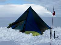
Camping
External Links
HEREGear used
Rope, pickets, ice axe, crampons, glacier gear(for approach to base of climb).
Getting There
There is a way to access this area via a trailhead called 7 mile saddle (from haines highway)and hiking through 3 mountain passes for a total of about 6 miles. This approach could add 2-3 days onto the trip(one way) depending on weather and fitness level of group. Clear sunny weather could turn into whiteout conditions in a very short time.The best way to access this beautiful area is via a 15 minute ski-plane flight from Haines airport. Besides, the views of Tukgahgo mountain and Peak 3920 are great! I would recommend pilot Drake Olson-flydrake.com for a flight to the area.
realdeal577 - Oct 14, 2010 1:49 pm - Hasn't voted
I knowHad it listed as west, came up on the page as east
realdeal577 - Oct 14, 2010 2:06 pm - Hasn't voted
Thanks!I don't know why it keeps happening, I fixed it.
Steve Gruhn - Oct 15, 2010 1:59 pm - Hasn't voted
"Peak 3920"Peak 3920 is known as Shakuseyi Peak on bivouac.com. http://www.bivouac.com/MtnPg.asp?MtnId=26998
realdeal577 - Nov 6, 2010 3:03 pm - Hasn't voted
Re:Thanks for the info Steve.