

lcarreau - Mar 22, 2009 2:40 pm - Hasn't voted
Sorry ...Nice photo of the Pendleton area, but you
can't see Mt. Rainier from Pendleton.
This can only be Mount Adams.

Iron Hiker - Mar 28, 2009 3:03 pm - Voted 10/10
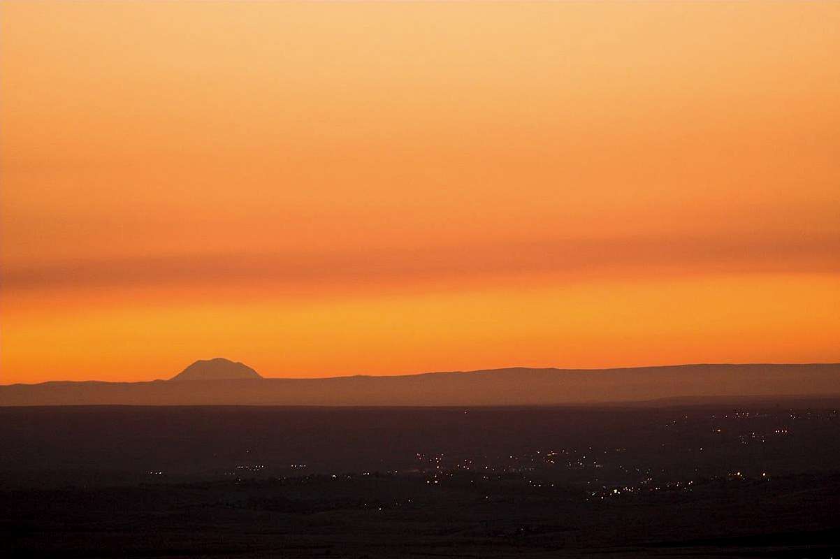
It CAN be Rainier.....According to my research, Rainier is 175 miles from the top of a hill on I-84 east of Pendleton. www.heywhatsthat.com clearly shows in its visibility cloak that Rainier is indeed visible from that location. You can't see Rainier itself from the actual town, however (in a valley).....

calebEOC - Mar 28, 2009 11:51 pm - Voted 10/10
Re: It CAN be Rainier.....Agreed, you can see adams, hood and rainier from the blue mountains when conditions are right. I've seen all 3 from Indian Rock near Austin Junction, which I know is further away than this pendleton shot is.
Iron Hiker - Mar 31, 2009 9:16 pm - Voted 10/10
Rainier it isJust checked Google Earth's 3D, and I pretty much can conclusively say it's Rainier. Point Success and Liberty Cap are clearly visible at both ends, and Adams doesn't have anything like Liberty Cap, a "little hump" at the right end of the summit area. Rainier is also a bit steeper than Adams, and that shows up well in this photo....

Ski Mountaineer - Apr 1, 2009 3:40 am - Hasn't voted
Re: Rainier it isagreed!

Bob Bolton - Apr 23, 2009 12:35 pm - Hasn't voted
Re: Rainier it isI can't agree with your arguments because Adams does look like this from the east if my memory serves. It does indeed have a central hump. The Adams equivalent of Point Success is called "Pikers Peak". I can't look now, but I believe the north ridge has a hump at the top too, much like Liberty Cap. If anything, it seems to me that Rainier should be steeper than this as well. So I can't rule out either one without knowing the angle. Interesting...
Bob Bolton - Apr 27, 2009 9:13 pm - Hasn't voted
Re: Rainier it isAfter further review, I do agree that this is Rainier. There is no point at the top of the Adams north ridge, and indeed this does look steeper than Adams.

billisfree - Feb 14, 2010 2:04 am - Hasn't voted
It's AdamsNope - it's Adams for sure.
http://i46.tinypic.com/2jcykyd.jpg
http://tinypic.com/m/91075k/1
I generated these images with my topographical program.
Adams has a "rounded" N. slope, while Rainier has a "straight" N. slope.
Adams has 3 "humps" on top, while Rainier has two.
The Rainier picture is missing Mt. Tahoma, which should reasonably be present in the picture.
The "hump" on the south side of Mt. Adams is Piker's Peak, not Rainier's "Point Success".
And again, the leveler slope on the south is consistant with Mt. Adams south approach. Mt. Rainer doesn't have this feature.
Iron Hiker - Feb 26, 2010 9:31 pm - Voted 10/10
I stick with RainierIt is clear that if you get a 3D image of Rainier from the ESE (i.e. via Google Earth), there ARE three humps - Point Success, Columbia Crest, and Liberty Cap. Your 3D image was taken too close to the mountain - when it's 175 miles away it will look quite different. Little Tahoma therefore is not able to stand out in profile since it's that much lower than the summit of Rainier. Just look at the GE 3D from an ESE perspective at about 12,000 feet and the shape of Rainier as shown in the photo will look pretty apparent.

Day Hiker - Feb 27, 2010 4:54 am - Hasn't voted
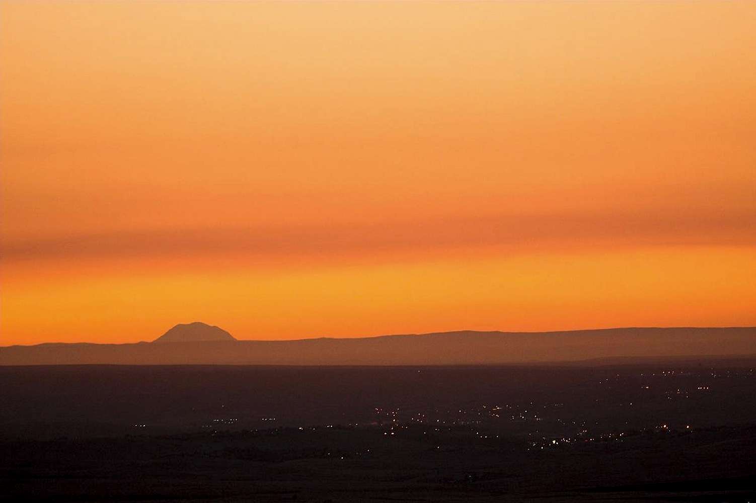
It is RainerI used my program to generate images of both Adams and Rainier from the Pendleton/I84 location described in the photo caption.
Compare the shapes. (Click for larger image.):

(link to thread with more description)
billisfree - Mar 5, 2010 5:41 am - Hasn't voted
You winOK, it's Rainier. Fun discussion.


Comments
Post a Comment