First True Class3 and a great introduction.
South Ridge Rt. via Montgomery Res. TH 9 miles RT 3,000' elevation gain Wheeler Mountain 13,690' Labor Day 2007
the road up to wheeler lake is rough...very very rough. there is absolutely no way any car with less than one foot clearance would make it and you can figure that out about 2 minutes in to the drive, so we being in a subaru hiked up the jeep trail to reach wheeler lake. started around 6:40 a.m. after getting a little bit lost in the early morning. there are two turns for CR4 off of hoosier pass depending on which way you are going, going south you'll turn right, north you'll turn left. if you are going north you will need your second left CR4 and if you are going south you will need your first right CR4. we missed it and ended up taking the second right CR4. it still all connects, just needed to address the map and it tacked on an extra 20 minutes or so as the roads were all dirt and a little bit slower of a go.
sunrise
(photo 1 and 2)
hike up the jeep road, looked a lot like this....but most parts had a lot of larger rocks...
(photo 3)
we got to wheeler lake (12,168') around 8 a.m. and hung out for a bit, it was very beautiful and there wasn't a soul around except for some marmots, deer, pica and a few fish feeding in the lake, oh and bugs..yes there were some bugs.
here is a picture...i drew the rest of the route out in blue. once we hit saddle at 13,350' we ducked off of the south ridge just slightly to the west so you cannot see the rest of our route. even thought the summit of wheeler is 1/4 of a mile away from it's connecting saddle it is a roller coaster of up and down all the way to the summit. i put two small blue dots on the top of wheeler...i believe the summit to be somewhere in between there. my boyfriend insisted that you could not see the summit from wheeler lake, i thought you could..either way, we definitely made it. more to come.
(photo 4)
this is what most of the hike from wheeler lake (12,168') to unnamed lake (12,510') was like...
(photo 5)
here is unnamed lake (12,510')
(photo 6)
so now it was time to work our way up to the saddle (13,350') where we would meet up with the south ridge leading to the summit of wheeler. (about an 840' elevation gain in 3/4 of a mile.) there was a very faint trail but we would lose it and regain it and lose it and regain it etc. etc. at times i would just go over large ribs of rocks to avoid the loose dirt/scree. there as evidence of old mines everywhere and i found my mind wandering (and peaking over to) the democrat/bross/lincoln trio that is closed due to old mine shaft dangers. then my boyfriend said something along the lines of 'i heard on the news that 2 girls who were mountain biking fell down an old covered up mine shaft and died'...we talked about that while we slogged away elevation.
this is what the part up to the saddle mostly looked like. there were very steep parts. my boyfriend twisted his knee on some loose rocks.
(photo 7)
finally the saddle was gained around 9:00 a.m...the fun was about to begin.
(photo 8)
![south ridge]()
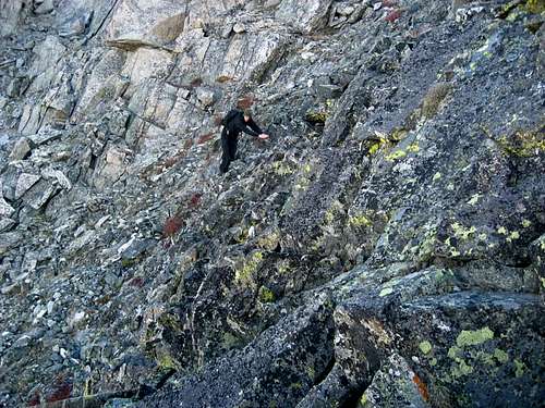
i basically took all of the photos on this trip except the very few i am in. on the way to the summit my boyfriend had the camera and honestly we were trying very hard to concentrate. the rock was very loose and untrustworthy. even giant rocks that seemed to be very sturdy would suddenly give out. certain areas were extremely exposed and there were also areas where a fall, a slip or a loose rock would have ended terribly. i loved every minute of it. cairns did mark the way but it wasn't too difficult to figure out where we needed to go..however, there really was no 'trail'. i got the feeling this mountain was not one traveled on much. i found myself flying through these difficult sections one after the other, with ease and grace. so so much different than the long slog up quandary peak where every minute felt like an hour. my boyfriend is excellent at just slogging up hill...i am terrible at it. but in this class three carnival i was the one leading, i was the one breezing through it. he was slightly nervous and it showed. i am in no way saying he struggled he was just not as 'pretty' at it as i was. this was my first real time in class 3 terrain. it really did require my full attention and i'm not going to lie there were a few spots when i was like 'holy crapoly'. it was also a roller coaster of up and down up and down. the pictures really won't do this ridge justice. if you really want to know what it's like, i suggest climbing it..it's a great secluded mountain and a great introduction to class 3.
here is a photo of me scrambling on the ridge going up
(photo 9)
here is the final summit pitch. i will try and explain this the best i can. the red arrow is pointing to a white 'Y' in the rock..this is natures way of telling us where the summit is! right above the 'Y'. woo hoo...otherwise it would be so hard to find. the dashed blue line is one route up (the easier of the two), the solid blue line is the route we chose to take up (the more difficult of the two. when we were standing in the bottom right of that photo looking up at it, the solid blue line route looked to be easier (more on this in a moment) but our guidebook said it was harder. the dashed blue line route was a steep gully full of obviously loose rock. so we decided, very sick of loose rock, we'd take the more difficult route which looked to be more solid and find out for ourselves why it was more difficult.
(photo 10)
it was more difficult because the final move that you have to make to gain the summit is totally and completely exposed, a fall or slip or miscalculation would mean death. however, there is good footing and holds. my boyfriend was flipping out as i went for it. after i pulled myself out of it i was on this tiny narrow platform of a rock. we then negotiated across a small narrow catwalk with very steep drops on either size to the tiny little itty bitty summit of wheeler mountain. it was 10:30 a.m. we signed the register and took some photos.
summit photo:
(photo 11)
this picture is from the summit looking back on the ridge...we came up on the left side of this, that's where the tough move is located. i should have marked it off with some blue paint in paint editor, but i didn't. i will leave it up to the imagination.
(photo 12)
we then proceeded to go down the dotted line route as we knew that that one move we had to make going up would be even more sketchy going down.
on the way down i led the whole way. there were points i was very far ahead of my boyfriend, something that never happens when we go do this sort of activity. i had the camera and took some pictures of him going down. these will give an idea of what this ridge was like. there was one move going down that was really scary. i will point it out in the pictures i am about to post.
(photos 13-16)
my boyfriend looks like a rock in this photo..he also looks like he's jumping VVV
(photo 14)
below is the move that really scared me on the way down. my boyfriend is taller than me so it was a bit easier for him. i had to put a lot of faith in to some scree below. i thought i was going for a long slide, but i worked it out.
(photo 17)
i thought these rocks looked neat..the one on the right was pretty much balancing there, it looked like a swift wind would blow it right off, but i imagined it had been there for decades.
(photo 18)
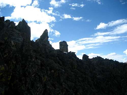
this is the first serious scrambling we did once gaining the ridge and the last bit on the way back to the saddle:
(photo 19)
the walk down was fairly uneventful, i was very excited that i had handled myself so well in a decent scramble. i felt this answered a lot of the questions that i had about my 'ability level' and how much more difficult i could go and how i didn't really want to do anything easier from this point forward. the hike down consisted of us going way off course and having to navigate down a fairly large rock band in to some lovely stinging plants which poked and pricked me all over the place.
once we got back to the unnamed lake i ate a pb&j sandwich while my boyfriend grabbed his fly rod that he had stashed on the way up and made a couple of casts. we then proceeded to head back down to wheeler lake which again consisted of sloppy boulder jumping and being stung by these evil plants.
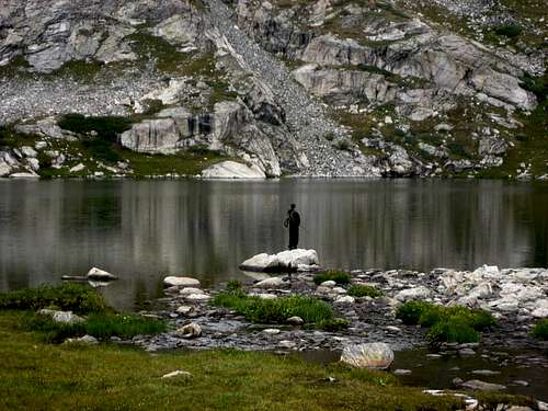
when we got down to wheeler lake i rested on a rock while my boyfriend fished.
(photo 20)
i took some photos of this waterfall
(photo 21)
my boyfriend caught a small brook trout and i got excited and ran down to the edge of the lake to see. he let it go and we then noticed that the fish were going crazy in the lake in some sort of feeding frenzy? but they weren't. it was raining? no, we didn't feel anything and the sun was out, it was so nice. there were a couple of rouge clouds, but nothing serious. it then starting puking out hail. out of know where. pelting us. the largest of the pieces were only about the size of a pencil eraser but it was coming down. and it was so random. what was not so great was the two hikers we had seen and heard (voices travel well in natural amphitheaters)going up i believe to north star mountain. what a late start!!! and they were only maybe shy of 1/2 way up with the steepest parts still ahead of them.
we decided to take off back down the jeep trail.
hail:
(photo 22)
end our solitude.
on the way down we saw many people, none hiking. just caravans of jeeps and other high clearance 4X4 vehicles heading up to probably trash wheeler lake. (i picked up SO much trash on this hike)..so much i couldn't pick it all up because i filled my pack and pockets.
the hail stopped but we kept looking behind us and noticing this storm building. we heard some rumbles of thunder right over wheeler mountain where we had just been. we were so glad we timed it right. not a place i would want to be in a hail/lightning storm. soon the storm had engulfed south platte gulch where we just had been.
almost back to our car we ran in to yet another caravan wielding children, dogs, beer and plenty of testosterone.
(photo 23)
we got back to our car around 2:30 and the storm had totally filled in and conjoined with other storms and finally caught up to us and unleashed.
we again thought of the two hikers in the middle of this storm that did blow up pretty quickly and hoped they had decided to turn around.
i loved this hike/scramble and i highly recommend it to anyone who likes a good scramble in solitude. and it's a good thing there were not any other hikers, rocks fly on this route.
the end.
H2 TEXT HERE
Comments
No comments posted yet.